The Younger Dryas Stadial: Ending of the Earth… Beginning of the World 

This writer’s interest in the Younger Dryas event is relatively recent during thirty years of research and thanks in the main to the investigative journalism of Graham Hancock. Consider this article a continuation of two previous articles: Monoliths of the Nephilim and Antartica: Secrets of the Lost Continent of Atlantis. Two chapters of The Noachian Legacy which dovetail with the subject matter and may be of interest to new readers seeking further discussion are: Chapter I Noah Antecessor Nulla and Chapter XXII Alpha & Omega. Of course, mention either Atlantis or the Nephilim and one’s credibility in mainstream academia and the orthodox scientific community drops to zero.

How ironic then, that a true understanding and accurate interpretation of mankind’s arcane past is only possible when incorporating the all persistent fairy tales of an advanced civilisation represented by Atlantis and its fall; coupled with and influenced by a pantheon of gods and a race of giant demigods – the Titans of mythology – Articles: Nephilim & Elioud Giants I & II. This pantheon of gods is deserving of a future article, though they have been introduced previously – refer articles: Principalities & Potentates: What they want… Who they are; Thoth; and Chapter XXII Alpha & Omega

On a personal note, I would not normally endorse another researcher or advocate to support them, but a question on the internet platform Quora, compelled me to defend his work. The reason being, that I find little fault in his theories and conclusions. The question and my answer are reproduced in their entirety for it serves as an appropriate introduction. 

Question: “Graham Hancock claims there is a mountain of undeniable evidence for a civilization that existed before ours. Is there any truth to this?” 

Answer: ‘Graham Hancock is correct and he is a brave soul for going up against the inflexible establishment of orthodox academia and scientists who either have an agenda to continue swimming in error and promulgate falsehood to the masses in keeping them in the dark; or who are genuinely blinded by their own intellectual vanity and self-importance. 

He is the visible focus point for all iconoclasts and contrarians in ancient history for both the Earth and its early civilisations. Worldwide ancient legends, archaeology, the geological record and even an accurate interpretation of the Bible, all support Hancock and the growing number of people with similar understanding. 

It is just a matter of time for all the pieces of the jig-saw puzzle on this subject to be discovered and put together. As with all debates and matters of disagreement, there are two sides. Only one is ever right. Yet invariably, it is the one which is incorrect who disdainfully looks down on the other as ignorant, simple minded and obtuse. But, when the truth is finally revealed, one side will be far more surprised (and embarrassed) than the other.’ 

A passionate response perhaps, yet hardly surprising considering the immense wall of obstruction put up against Hancock, his theories and his conclusions by a threatened and intimidated Establishment whom are not ready to acknowledge the ramifications and validity of the growing evidence, or to re-write humanities early history as a result. Admitting they have been in error regarding humankind’s evolution as not a gradual upward curve at all but an undulating one instead, is abhorrent and unthinkable. In response, the insults directed at Hancock whether based professionally or personally have plummeted to new lows in their degradation towards the intrepid investigator. But, history shows all new ideas and theories which are correct, eventually win out, no matter how many decades of denial persist. 

Graham Bruce Hancock was born August 2, 1950 in Edinburgh and is a British writer who opponents claim promotes pseudoscientific theories – because they challenge mainstream science – involving ancient civilisations and hypothetical lost lands. Hancock’s premise is that an advanced ice age civilisation was destroyed in a global cataclysm and its survivors preserved their knowledge regarding agriculture; monumental architecture; and astronomy to hunter-gatherers around the world; which in turn gave rise to the early civilisations and cultures in Egypt, Mesopotamia and Mesoamerica. 

Online Encyclopaedia: ‘Reviews of Hancock’s interpretations of archaeological evidence and historic documents have identified them as a form of pseudoarchaeology or pseudohistory containing confirmation bias supporting preconceived conclusions by ignoring context, cherry picking, or misinterpreting evidence, and withholding critical countervailing data. His writings have neither undergone scholarly peer review nor been published in academic journals.’ 

This is merely the opinion of his detractors in the scientific community who maintain closed ranks over a conspiracy like agenda to misinform the populace and not of the millions of civilians who think for themselves and recognise the fundamental flaws in the established evolutionary view of humankind’s supposed technical progression. Plus, scientists hold high value in the dates they propose, yet these are open to serious question, for carbon dating is often seriously skewed beyond four thousand years ago, while other dating is influenced by the desire to uphold evolution lasting millions of years, when in reality it is only tens of thousands of years in length – Appendix IV An Unconventional Chronology

Hancock has brought the concept of mankind’s widespread amnesia about a global catastrophe almost wiping out humanity during the Younger Dryas to a wider audience through the 2022 documentary released by Netflix, Ancient Apocalypse. Of the eight episodes, the fifth one, Legacy of the Sages about Gobekli Tepe and Karahan Tepe was of special interest. Of which it was included in a previous article: Monoliths of the Nephilim. The other episode of specific interest was the last one and we will discuss its contents in due course as well as Hancock’s thoughts and conclusions on the Younger Dryas event. 

Opponents are quick to point out the coincidence of Hancock’s son Sean, being ‘senior manager of unscripted originals’, which has no bearing on the content of the program. The series concentrates on megalithic sites around the world and how they are evidence of his central premise. At the same time claiming that ‘archaeologists are ignoring or covering-up this alleged evidence. It incorporates ideas from the Comet Research Group (CRG), including the controversial Younger Dryas impact hypothesis, which… attributes climate change at the end of the Pleistocene to a massive meteor bombardment. Archaeologists and other experts have described the theories presented in the series as lacking in evidence and easily disproven. It has been criticised for failing to present alternative hypotheses or contradicting evidence, and for unfounded accusations that “mainstream archaeology” conspires against Hancock’s ideas.’ 

The ultimate low blow – as can be directed at research which claims to identity the origins of people or which supports any kind of platform supporting racial theories for instance – is that ‘Archaeologists have linked Hancock’s claims to “racist” and “white supremacist” ideologies from the 19th century, which they say are insulting to the ancestors of indigenous peoples who built the monuments.’ Constant readers will realise that it is a matter of perspective regarding who built megalithic monuments and who is actually being forgotten or insulted – refer articles: Monoliths of the Nephilim; and Antartica: Secrets of the Lost Continent of Atlantis.

‘The Society for American Archaeology (SAA) objected to the classification of the series as a documentary and requested that Netflix reclassify it as science fiction.’ This laughable finger pointing by the very ones who have been spinning a yarn for decades. ‘The SAA also stated that the series: “Repeatedly and vigorously dismisses archaeologists and the practice of archaeology with aggressive rhetoric, willfully seeking to cause harm to our membership and our profession in the public eye… the theory it presents has a long-standing association with racist, white supremacist ideologies; does injustice to Indigenous peoples; and emboldens extremists.”

One irony being that nearly all the megalithic monuments in question were not built by either Native Indigenous people, or by ancestors of White Europeans. Rather, a race of formidable Elioud giants descended from the Nephilim are responsible and so would that not be racist and insulting against them? – refer articles: Nephilim & Elioud Giants I & II; Chapter XXII Alpha & Omega; and Chapter XXI The Incredible Identity, Origin & Destiny of Nimrod.

It was during independent research, that this writer became convinced how the Last Glacial Maximum from 27,000 to 20,000 years ago – preceded the global cataclysm which destroyed all human life, all animal, all insect and all bird life, save on the Ark, as described in the Bible during the Flood – Genesis 6:7. 

It was discovered that dating for the pre-flood patriarchs incorrectly based on a decimal system instead of a sexagesimal count; as well as inadvertently adhering to an inaccurate post-flood chronology, altered through editing was an error. Using an unconventional chronology to re-align the biblical account with scientific data, resulted in the date of 10,837 BCE for the great deluge. Imagine the surprise and satisfaction to learn that the beginning of the Younger Dryas Stadial is dated to precisely the same time frame.

What is the Younger Dryas event exactly? The Younger Dryas was the last cool interval occurring  approximately between 12,900 and 11,600 years ago – remarkably, 10,875 to 9575 BCE – which disrupted the prevailing warming trend occurring at the end of the Pleistocene and preceded the beginning of the current, warmer Holocene epoch. Various researchers believe that this is what caused the worldwide Mega Fauna Extinction Event that occurred at the same time.

dryas octopetala

The event is named after the Dryas, an alpine-tundra wildflower that grows around the Artic Circle and whose leaves thrive in the cold, It is abundant in certain sedimentary deposits dated to this epoch, when it became common. In determining how much pollen is found in annual layers of lake sediment called varves, researchers have estimated where the boundary of the Arctic Circle was during a given time. The further south, the greater the glaciation. The further north, the greater the warming. 

It is the contention of this writer that the Younger Dryas was an epochal transformation event which decimated the Adamic Age, ending it dramatically and in turn, ushering in the legacy of the Noachian world we live in today. Thus, the Younger Dryas Stadial was at once a sudden yet protracted process that brought about a major and abrupt change of the world climate over the course of about 1,300 years. The temperature drop was massive, with the globe entering into a near-glacial period where it was extremely cold and windy. This occurred almost immediately after there was an increase of temperatures following the previous glacial period about, 14,500 years ago and lead to a sudden warming which put an end to the Ice Age period which had lasted thousands of years. 

Encyclopaedia: ‘The Younger Dryas was the most severe and longest lasting of several interruptions to the warming of the Earth’s climate, and it was preceded by the Late Glacial Interstadial (also called the Bølling-Allerød interstadial), an interval of relative warmth that lasted from 14,670 to 12,900 BP.’

According to World Atlas: ‘[This] warming led to the melting of massive ice deposits in North America and Europe…’ The conditions changed again soon after entering the Younger Dryas period and ended over a thousand years later when the climate warmed again with Greenland recording a 10°C temperature increase in a decade. The Younger Dryas is a stand out event in history and the manner in which it ended abruptly confounds scientists. The question as to what caused the Younger Dryas is hotly debated and has led to numerous explanations being put forward to explain the event, with no unified agreement being reached. 

The Younger Dryas event was unlike any normal climate change and was bound to have unique repercussions on the world. Temperature fluctuations not only occurred before and after but also during the phenomenon. The change was relatively sudden, took place over decades and resulted in advances of glaciers and drier conditions over much of the temperate Northern Hemisphere. In England, glaciers began to form, caused by extremely low temperatures. While in the Netherlands, the temperatures fell below -20°C during the winter season. Of all the regions affected by the Younger Dryas, it was in Greenland that the effects were the worst, with the ice cores recording a temperature drop of 15°C. Trees were affected the most in Europe, with alpines and tundra becoming dominant after the original trees had retreated. 

Scientists have long been aware of the presence of a distinct cold period at the end of the Last Glacial Maximum. ‘Paleobotanical and lithostratigraphic studies of Swedish and danish bog and lake sites, as in the Allerod clay pit in Denmark, first recognized and described the Younger Dryas. The Younger Dryas is the youngest and longest of three stadials, which resulted from typically abrupt climatic changes… the prefix “Younger” refers to the recognition that this original “Dryas” period was preceded by a warmer stage, the Allerod oscillation, which, in turn, was preceded by the Older Dryas, around 14,000 calibrated years BP… [and] generally accepted to have lasted around 200 years. 

In northern Scotland, the glaciers were thicker and more extensive than during the Younger Dryas. The Older Dryas, in turn, was preceded by another warmer stage, the Bolling oscillation, that separated it from a third and even older stadial, often known as the Oldest Dryas. The Oldest Dryas occurred about 1,770 calibrated years before the Younger Dryas and lasted about 400 years. According to the GISP2 ice core from Greenland, the Oldest Dryas occurred between about 15,070 and 14,670 calibrated years BP.’

‘In Ireland, the Younger Dryas has also been known as the Nahanagan Stadial, and in Great Britain it has been called the Loch Lomond Stadial. In the Greenland Summit ice core chronology, the Younger Dryas corresponds to Greenland Stadial 1 (GS-1). The preceding Allerød warm period (interstadial) is subdivided into three events: Greenland Interstadial-1c to 1a (GI-1c to GI-1a). 

Analyses of stable isotopes from Greenland ice cores provide estimates for the start and end of the Younger Dryas. The analysis of Greenland Summit ice cores, as part of the Greenland Ice Sheet Project 2 and Greenland Icecore Project, estimated that the Younger Dryas started about 12,800 ice (calibrated) years BP. More recent work with stalagmites strongly suggests a start date of 12,870 ± 30 years BP, consistent with the more recent North Greenland Ice core Project (NGRIP) ice core data.’ 

This is of immense importance and interest, as an unconventional chronology supports a global cataclysm occurring in the year 10,837 BCE. When this writer began researching, little did they realise that stalagmites would corroborate these findings and offer a date of 10,846 BCE +/- 30 years. Thus, a mere nine years separates the two dates, which is within the mean of 30 years and so the dates actually synchronise. Perhaps Noah’s flood, recorded in a book of fanciful fables, may have been a reality which transpired after all? – Chapter I Noah Antecessor Nulla. 

Encyclopaedia: ‘Depending on the specific ice core analysis consulted, the Younger Dryas is estimated to have lasted 1,150-1,300 years. Measurements of oxygen isotopes from the GISP2 ice core suggest the ending of the Younger Dryas took place over a period of about 50 years. Other proxy data, such as dust concentration and snow accumulation, suggest an even more rapid transition, lasting for 30 years or less, potentially as rapid as less than 20 years. Greenland experienced about 7 °C (13 °F) of warming in just half a century. Total warming in Greenland was 10 ± 4 °C (18 ± 7 °F). The end of the Younger Dryas has been dated to around 11,550 years ago, occurring at 10,000 BP… The International Commission on Stratigraphy put the start of the Greenlandian stage, and implicitly the end of the Younger Dryas, at 11,700 years before 2000 [or 9700 BCE].’

There are three main theories on the cause of the cataclysm during the Younger Dryas, yet the answer may lay in all three being contributing factors. The incredible worldwide devastation caused during this monumental earth-changing event is discussed in a previous chapter – Chapter I Noah Antecessor Nulla

The hypothesis historically most supported and accepted by scientists was the premise that the Atlantic Meridional Overturning Circulation (AMOC), which transports warm water from the Equator towards the North Pole, was interrupted by an influx of fresh, cold water from North America into the Atlantic. This intrusion of water is said to have originated from Lake Agassiz which broke its bank and released freshwater into the Labrador Sea, in turn floating on the salty water. This then blocked the AMOC current which transports heat to the north using its warm waters – in essence a shutdown of the North Atlantic conveyor. This blockade led to Northern Europe freezing. This is also known as the Thermohaline Circulation (THC) disruption where the North Atlantic froze while the South Atlantic warmed. For research shows that if the THC was disrupted, less heat would reach the north from the south. 

However, some discredit this explanation as research also shows a similar water release happened after the end of the Younger Dryas. This raises questions as to why the climate was not affected in the same way. There are in fact several issues relating to the hypothesis, one of which is the ‘lack of a clear geomorphological route for the meltwater. In fact, the originator of the meltwater hypothesis, Wallace Broecker, stated in 2010 that “The long-held scenario that the Younger Dryas was a one-time outlier triggered by a flood of water stored in proglacial Lake Agassiz has fallen from favor due to lack of a clear geomorphic signature at the correct time and place on the landscape.”

Encyclopaedia: ‘The lack of geological evidence for such an event…’ or a ‘consensus… on the precise source of the freshwater… [means] the freshwater pulse hypothesis has… been called into question… originally the freshwater pathway was believed to be the Saint Lawrence Seaway, [but] the lack of evidence for this route has led researchers to suggest alternative sources for the freshwater’ including: a pathway along the Mackenzie River: de-glacial water coming off of Scandinavia; the melting of sea ice; increased rainfall; or increased snowfall across the North Atlantic. 

It perhaps could be viewed that any disruptions to the AMOC and THC are results of the cataclysm and not necessarily its cause. Another plausible theory is that the reason why the water stream changed its course and went northward was caused as a consequence of deglaciation (melting ice sheet) in North America. This, in turn, led to an increased amount of rain in the North Atlantic which sufficed to disrupt the THC.

A further related explanation is that the El Nino-Southern Oscillation was affected in response to changes which occurred in Earth orbital patterns. This explanation is discredited because it cannot explain how such an event affects regions far from the tropics. Yet it raises an important question in what could cause a change in Earth’s orbital pattern? A passing cosmic body, such as a comet, meteors or even another planet perhaps? 

‘The global climate would then have become locked into the new state until freezing removed the fresh water “lid” from the North Atlantic.’ Simulations indicate that a ‘one-time-flood’ is unlikely to have caused the ‘new state to be locked for 1,000 years. Once the flood ceased, the AMOC would recover and the Younger Dryas would stop in less than 100 years. Therefore, continuous freshwater input would be necessary to maintain a weak AMOC for more than 1,000 years. A 2018 study proposed that the snowfall could be a source of continuous freshwater resulting in a prolonged weakened state of the AMOC. The lack of consensus regarding the origin of the freshwater, combined with the lack of evidence for sea level rise during the Younger Dryas, are problematic for any hypothesis where the Younger Dryas was triggered by floodwater.’ 

Theses two points are not issues unless one make them so. First, the cataclysm which afflicted the Earth, caused global flooding from a combination of sources, including eruptions of springs from under the oceans and the falling of the canopy in the atmosphere above – not just from lakes and rivers – Chapter I Noah Antecessor Nulla. Second, whether the sea level rose or not – and it would have – is secondary to the violence of the earthquakes and tidal waves which ripped across the world’s oceans and landmasses in their path. 

The second – and increasingly well-supported – alternative to the meltwater trigger, is that the Younger Dryas calamity was the result of volcanic activity. The ‘presence of anomalously high levels of volcanism immediately preceding the onset of the Younger Dryas has been confirmed in both ice cores and cave deposits.’ In fact ‘numerous papers now confidently link volcanism to a variety of cold events… and in particular several note the ability of volcanic eruptions to trigger climate change lasting for centuries to millennia.’ 

Encyclopaedia: It has been ‘proposed that a high latitude volcanic eruption could have shifted atmospheric circulation sufficiently to increase North Atlantic sea ice growth and slow down AMOC, subsequently leading to a positive cooling feedback and initiating the Younger Dryas.  

Particularly strong support comes from sulphur data from Greenland ice cores showing that the radiative forcing associated with the cluster of eruptions immediately preceding the Younger Dryas initiation “exceeds the most volcanically active periods during the Common Era, which experienced notable multidecadal scale cooling commonly attributed to volcanic effects”. Notably, the sulphur data strongly suggest that a very large and high latitude northern hemisphere eruption occurred 12,870 [10,846 BCE] years ago, a date indistinguishable from the stalagmite-derived onset of the Younger Dryas event. 

It is unclear which eruption was responsible for this sulphur spike, but the characteristics are consistent with the Laacher See eruption [located in Rhineland-Palatinate, Germany], as the source. The eruption was dated to 12,880 ± 40 years BP [10,856 BCE (+/- 40 years), offers a mere nineteen years separating this date with the unconventional chronology date of 10,837 BCE for the flood], by varve counting sediment in a German lake and to 12,900 ± 560 years by 40Ar/39Ar dating, both of which are within dating uncertainties of the sulphur spike at 12,870 years BP, and make the Laacher See eruption a possible trigger for the Younger Dryas.’ 

A ‘new radiocarbon date [challenged] the previous dating for the Laacher See eruption, moving it back to 13,006 years BP, but this date itself has been challenged as potentially having been affected by radiocarbon ‘dead’ magmatic carbon dioxide, which was not accounted for and made the date appear older than it was. Regardless of the ambiguity surrounding the date for the Laacher See eruption, it almost certainly caused substantial cooling either immediately before the Younger Dryas event or as one of the several eruptions which clustered in the ~100 years preceding the event [during the Older Dryas]. A volcanic trigger for the Younger Dryas event also explains why there was little sea level change at the beginning of the event. Furthermore, it is also consistent with previous work that links volcanism with [Dansgaard-Oeschger] events and with the perspective that the Younger Dryas is simply the most recent D-O event.’ 

Another theory is that a solar flare might have been responsible for the megafaunal extinction which occurred during the Younger Dryas, but this alone cannot account for the apparent variability in the timing of the extinction across all the continents. 

The third cause for the Younger Dryas event is the impact hypothesis [or Clovis comet hypothesis], which attributes the cooling that occurred to the cosmic ‘impact of a disintegrating comet or asteroid.’ An impact of this type would have left a ‘lot of debris that cooled the climate fast and in turn [eliminated] certain species’ due to the extreme conditions. Interestingly, this ‘idea is rejected by most experts though it is promoted by pseudoscientific archaeology television.’

A dig here – no pun intended – at all those who advocate this theory such as Graham Hancock. One can’t help but wonder if scientists deliberately support volcanism as the trigger for the Younger Dryas period, in their effort to distance themselves from a Great Flood as described in myriad myths world-wide. And what would cause a global flood perchance? A cosmic impact certainly would. 

An increase in volcanic eruptions preceding a comet strike for instance, could have been symptomatic of the beginning of lethal activity preceding the foretold disaster. The molten layers of lava beneath the Earth’s crust could well have been heating to dangerous levels, becoming less viscous and allowing the movement of the Earth’s crust to become volatile, which would then facilitate the destructive power of earthquakes and seismic shifts in the continual landmasses when a comet, asteroid or meteors struck in 10,837 BCE. 

Online Encyclopaedia: ‘It is worth noting that of the proposed Younger Dryas triggers, the volcanic trigger is the only one with evidence that is almost universally accepted as reflecting the actual occurrence of the trigger. No consensus exists that a meltwater pulse happened, or that a bolide impact occurred prior to the Younger Dryas, whereas the evidence of anomalously strong volcanism prior to the Younger Dryas event is now very strong.’ Even so ‘outstanding questions include whether a short-lived volcanic forcing can trigger 1,300 years of cooling, and how background climate conditions affect the climate response to volcanism.’ 

The end of the Younger Dryas was caused by an increase in carbon dioxide levels and a shift in the Atlantic Meridional Overturning Circulation. There are other examples of climate fluctuations similar to the Younger Dryas over the past 50,000 years like the Heinrich event; the Dansgaard-Oeschger phenomenon; and the Akkadian Collapse. 

A Heinrich event is a natural phenomenon, where a prodigious volume of icebergs break off from the Laurentide Ice Sheet, traversing the Hudson Strait into the North Atlantic. It was first described by marine geologist Hartmut Heinrich. Dansgaard-Oeschger events (D-O) – named after palaeoclimatologists, Willi Dansgaard and Hans Oeschger – are rapid climate fluctuations that have occurred 25 times during the last glacial period.

It is often noted that the Younger Dryas is merely the last of these major climate D-O events over the past 120,000 years. ‘These episodes are characterized by abrupt beginnings and endings (with changes taking place on timescales of decades or centuries). The Younger Dryas is the best known and best understood because it is the most recent… [of the] cold phases…’ yet fundamentally different, due to the violence which destroyed nearly all life on Earth. 

Abrupt Climate Change During the Last Ice Age, Matthew W Schmidt & Jennifer E Hertzberg (Department of Oceanography, Texas A&M University), 2011:

‘Unlike the relatively stable climate Earth has experienced over the last 10,000 years, Earth’s climate system underwent a series of abrupt oscillations and reorganizations during the last ice age between 18,000 and 80,000 years ago (Dansgaard 1984, Bond et al. 1997, 1999). These climate fluctuations were first discovered when scientists reconstructed past temperature variability over Greenland by analyzing tiny changes in the relative abundance of the oxygen-16 isotope versus the oxygen-18 isotope (noted as δ18O and reported in parts per thousand) in ice cores recovered from Greenland glaciers. 

Each successively deeper ice layer represents a snapshot of Earth’s climate history from the past, and together, the oxygen isotope record told a story of abrupt, millennial-scale climate shifts in air temperatures over Greenland between extremely cold stadial conditions and relatively mild interstadial periods during the last ice age (Alley 2000, Alley et al. 2003). There are twenty-five of these distinct warming-cooling oscillations (Dansgaard 1984) which are now commonly referred to as Dansgaard-Oeschger cycles, or D-O cycles. One of the most surprising findings was that the shifts from cold stadials to the warm interstadial intervals occurred in a matter of decades, with air temperatures over Greenland rapidly warming 8 to 15°C (Huber et al. 2006). Furthermore, the cooling occurred much more gradually, giving these events a saw-tooth shape in climate records from most of the Northern Hemisphere.’ 

The current conviction is that volcano activity initiated the Younger Dryas – while being a precursor or result of an extraterrestrial mechanism is not considered. In the process displacing the theory of massive meteor impacts. Ivan Petricevic, August 2, 2020, says ‘… unprecedented volcanic activity was previously confused with extraterrestrial impacts…’ and that ‘…the geochemical signature [presumably from volcanic activity] associated with the cooling event is not unique but occurred at least four times between 9,000 and 15,000 years ago [13,000 to 7000 BCE]. Alan Brandon, professor of geosciences at the University of Houston, revealed in a statement that… Previous geochemical evidence of a large meteorite exploding in the atmosphere reflects a period of major volcanic eruptions… the cooling episode, scientifically known as the “Younger Dryas” was caused by numerous coincident Earth-based processes, not by an extraterrestrial impact.’ 

Thus geochemical evidence of meteorites has switched to now reflecting volcanic eruptions. Convenient, as it deflects from the unpalatable truth of a flood caused by a cosmic impact. The period after the Flood saw an unstable world, where it took centuries to dry out, to become farmable, and millennia to settle into rhythmic patterns of weather and a stable settlement of the Earth’s crust. Therefore, earthquakes, volcanic eruptions and severe regional flooding such as in the Black Sea region circa 6700 BCE is not a surprise. 

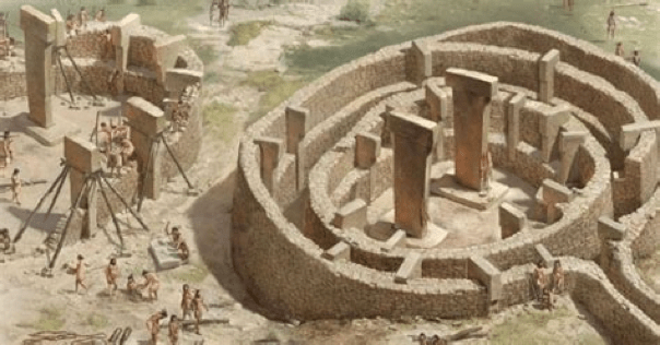
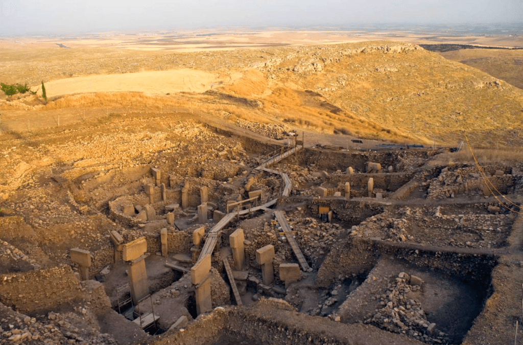
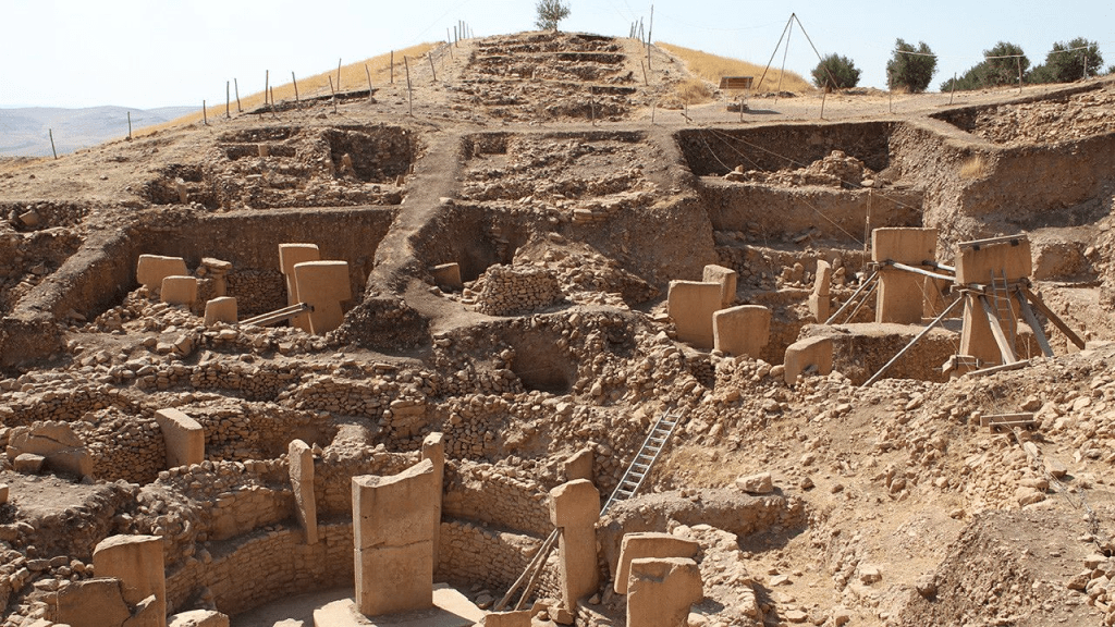
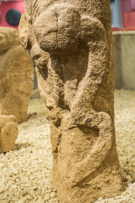
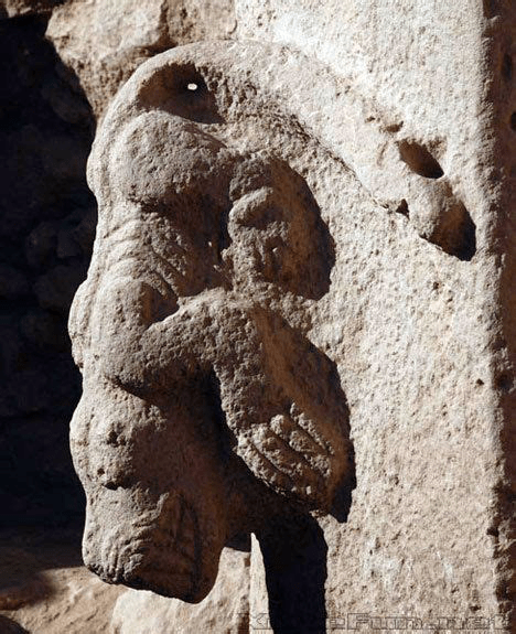
We were introduced to Martin B Sweatman, a Reader (Associate Professor) at the University of Edinburgh in the article, Monoliths of the Nephilim. ‘His research, involving the statistical analysis of the motion of atoms and molecules (statistical mechanics and molecular thermodynamics) has helped him solve one of the world’s greatest puzzles – the meaning of ancient animal symbols found in Palaeolithic caves, and [Pillar 43] at Gobekli Tepe… This breakthrough enables the dating of prehistoric artworks using an entirely new method – zodiacal dating. 

His article, Volcanic or cosmic impact origin of the YD mini ice-age? New evidence from Hall’s Cave, Texas, August 6, 2020, is in response to the switch in thinking about the cause of the Younger Dryas. Sweatman: ‘Until now, over 60 primary peer-reviewed journal papers together with dozens of supporting responses all agree the Younger Dryas event was caused by Earth’s collision with debris from a disintegrating comet. Only one paper has previously suggested it was caused by the Laacher See volcanic explosion – and that paper was thoroughly refuted only a year later.

… the sediment of Hall’s Cave, Texas… has accumulated over tens of thousands of years, providing a convenient record of environmental conditions near the cave over this time. An easily visible transition in the colour of the sediment at a depth around 1.51 m signifies a dramatic change in climate, and has been suggested to indicate the onset of the Younger Dryas climate anomaly when the Northern Hemisphere experienced a sudden return to near ice-age conditions for over 1000 years.’ 

‘This view is supported by the discovery in this boundary layer of the same kinds of microscopic impact debris found at many other Younger Dryas boundary sites across four continents. So, it appears that Hall’s Cave is yet another record of this most dramatic and important cosmic impact event, thought to have reset human Cultures and extinguished many species of large animal across the globe. An event that is probably remembered by numerous extant religions, and might even have helped trigger the rise of our own civilisation.’

Younger Dryas Boundary Field – Graphic from Kinzie, Firestone, Kennett et al. “Nanodiamond-Rich Layer across Three Continents Consistent with Major Cosmic Impact at 12,800 Cal BP”, The Journal of Geology, 2014, volume 122, pages 475 – 506

‘… the dinosaur-killing Chicxulub impactor was particularly rich in iridium, and coated Earth in an iridium-rich layer of dust and debris. However, we know from analysis of the GISP2 ice core in Greenland, that the Younger Dryas impactor was instead rich in platinum. Since that discovery peaks in platinum concentration within sediments have been used to locate the Younger Dryas boundary accurately at many other sites… asteroids – that originate from the asteroid belt in the inner solar system – tend to be rich in osmium, and osmium enhancement is therefore a good indicator of an asteroid strike, the same is not known to be generally true for comets. Yet the prevailing model of the Younger Dryas impact involves a highly fragmented comet, not an asteroid.

… volcanic eruptions can also produce abundances of platinum group metals, since these metals are more highly concentrated in Earth’s interior than its crust… osmium by itself cannot be used to distinguish between a volcanic eruption and a cosmic impact, especially if caused by a comet… there are far better indicators and proxies for these very different events that can easily discriminate between them. Sulphates are known to be excellent in this respect, with a strong sulphate abundance clearly indicating a volcanic eruption. We know from high-resolution analysis of the GISP2 ice core that there is no significant sulphate signal at the onset of the Younger Dryas cooling. Moreover, a strong sulphate spike in the GISP2 ice-core, thought to signify the Laacher See eruption, precedes the Younger Dryas climate transition by around 100 years and is not associated with any significant cooling.’ 

Thus supporting, with the Laacher See eruption at least during the Older Dryas, that it was a precursor to the Younger Dryas and not the ignition of it.  ‘As the GISP2 ice core is sampled at roughly 3-year intervals, it is a much better record than Hall’s Cave, which is effectively sampled at 50 to 100 year intervals… abundances of magnetic microspherules, containing over 85% iron, have been found at the Younger Dryas boundary layer in various locations, strongly indicating a cosmic impact and contra-indicating a volcanic eruption. Quite simply, it is impossible for a volcanic eruption to produce these iron-rich particles. The Laacher See eruption is therefore unequivocally ruled out as the cause of the Younger Dryas boundary layer. Clearly, then, the focus on osmium by Sun et al., by itself a poor discriminator of a comet impact versus a volcanic eruption, is not useful in this debate.’ 

Sweatman’s analysis and critique of Sun et al. paper in Science Advances, July 31, 2020 can be found at the following link:

A further point of interest aside from Martin Sweatman’s article, were comments supporting this writer’s research on the time frame of the Younger Dryas and specifically the flood cataclysm. One comment confirmed that a ‘cosmic impact of the proposed magnitude would induce volcanic activity, among other seismic events. They’re clearly not mutually exclusive events.’ 

An anonymous comment claimed the following:

‘For the record, I was the first to discover and publicly claim on the Cosmic Tusk site (in the comments) that the Laacher See eruption was caused by an impact… on a volcanic field which resulted in subsequent eruption. In Laacher See tephra, all 14 rare earth elements have enhanced abundances by the factor of 20-30, and there are other anomalies which make this eruption quite unique. It is the only known impact caused eruption. The event happened on June 29, 10,961 BC, Gregorian calendar, and it is the year marked on the Göbekli Tepe’s Pillar 43. Sweatman’s claim of 10,950 BC +/- 250 for this I reduced to 10,961 BC +/- 0 years…’ 

This date, 10,961 BC, is 124 years before the flood in 10,837 BCE and fits with the volcanic activity beginning approximately one hundred years before the Younger Dryas cataclysm – Genesis 6:3. The significance of this time frame has biblical support. Though it does not concur with the dating of Pillar 43 being 10,961 BC.

Ronald Sechler adds: 

‘The earth is growing and expanding, because it has a fission core [equivalent of a nuclear reactor]’ – Article: Nuclear Nefariousness. ‘The growing and expanding causes the earth to go out of balance over time. Asteroid or comet impacts send shock waves through the crust and mantle of the earth, causing the crust to crack and break allowing mantle material to flow out over the crust. As balance is quickly lost the earth experiences an extreme wobble. All… major mass extinction events are [caused] by the growing and expanding earth.’

Ad Roest states: 

‘When will researchers accept the fact that the earth is suffering from a regular recurring “space impact”. A real impact does not return regularly so the cause of this is not a comet. Ancient books tell us that this must be caused by a heavenly body that causes a cycle of seven natural disasters. The only cause of such a cycle is a ninth planet [aka Planet X or Nibiru] in our solar system’ – Chapter XXII Alpha & Omega. ‘That exists says NASA but they don’t see it. Ancient sources know about an invisible ‘star’. I reconstructed our history using many ancient sources including the bible. The most recent worst “space impact” occurred in the year 10,844 BC.’ 

This comment was of particular interest. A collision with a planetary body has happened to the Earth before about 35,000 years ago. This same body may well have hit and gouged Mars 13,000 years ago and at the same time either scraped our globe or passed close enough for its accompanying trailing comet(s) and its meteor fragments, to rain down upon the Earth. The date given of 10,844 BC is exceptionally accurate in this writer’s estimation and within seven years of their own calculation: 10,837 BCE. It relays confidence in the accuracy of the two dates after weighing together available data and information.  

While this writer personally subscribes to a ninth planet theory – with volcanism and flooding byproducts or side affects – lets go with a comet impact hypothesis for the sake of simplicity. Graham Hancock endorses a book which solidly combats the opponents of a comet strike as the cause of the Younger Dryas, where he states: 

‘Did impacts and airbursts from multiple fragments of a disintegrating comet cause the onset of the Younger Dryas global cataclysm 12,800 years ago? After more than a decade of acrimonious scientific controversy around the Younger Dryas Impact Hypothesis (YDIH), an important new book by eminent geologist Dr James L. Powell answers this question in great depth and sets the record straight with a resounding YES. Titled “Deadly Voyager: The Ancient Comet Strike That Changed Earth and Human History”, this thoroughly researched… study systematically demolishes all the criticisms of the YDIH that have been made… by scientific opponents. 

What makes Powell’s book so significant, however… is its thorough documentation of how solidly-based on compelling geological evidence the YDIH really is, and the rational and balanced way in which it reveals the flaws of the scientific process – the personal grudges, the vested interests in the orthodox paradigm, and the axes to grind – that for so long were allowed to mislead the public about the truth of the matter. It is sadly the case, as Powell does not hesitate to remind us, that some scientists are willing to use “sleight-of-hand… to ward off a theory that they have long denied. But evidence always wins out, and all such scientists accomplish is first, to delay scientific progress and second, to besmirch their reputation in history.”

The notion that a comet struck North America at the end of the last ice age was initially proposed as a ‘speculative premise’ by the American congressman and alternative historian, Ignatius Donnelly in 1883 – refer Donnelly, article: Antartica: Secrets of the Lost Continent of Atlantis. He suggested it formed the Great Lakes, causing a sudden extreme cold period, which devastated animal and human populations. After a long hiatus, it has since gained widespread attention, when this hypothesis entered widespread scientific discussions at the May, 2007 meeting of the American Geophysical Union in Acapulco, Mexico. Even though the YDIH was formally debuted in 2007, a version of the hypothesis first appeared from Firestone and Topping in 2001, followed by substantial elaboration in the Firestone, West, and Warwick-Smith book of 2006. 

From The Cosmic Tusk, a lesser known essay by Graham Hancock on the YDIH is the rather lengthy quote which follows – emphasis and bold mine. Though not reproduced in its entirety, the salient points were deemed important to include.

‘The epoch which geologists call the Younger Dryas has… been recognized as mysterious and tumultuous. When it began 12,800 years ago the earth had been emerging from the Ice Age for roughly 10,000 years, global temperatures were rising steadily and the ice caps were melting. Then there was a sudden dramatic return to colder conditions – nearly as cold as at the peak of the Ice Age 21,000 years ago [in 19,000 BCE]. This short, sharp deep freeze lasted for 1,200 years [Genesis 6:3] until 11,600 years ago [9600 BCE] when the warming trend resumed with incredible rapidity, global temperatures shot up again and the remaining ice caps quite quickly melted away, dumping all the water they contained into the oceans and raising sea level significantly all around the world. 

The Younger Dryas Impact Hypothesis is… the work of highly-qualified scientists from universities in countries, collaborating as the Comet Research Group. Members include nuclear analytical chemist Richard Firestone – a nuclear analytical chemist – of the Lawrence Berkeley National Laboratory, world-renowned oceanographer Jim Kennett of the University of California, Wendy Wollbach Professor of Inorganic Chemistry and Geochemistry at DePaul University, Albert Goodyear, Professor of Archaeology at the University of South Carolina, Geophysicist Allen West, Astrophysicist Malcolm Le Compte, Geologists James Teller and Ted Bunch – and more than 50 other leading researchers from a wide range of disciplines. 

“Probed as to why no crater had yet been identified with this hypothetical impact 12,900 years ago… Arizona-based geophysicist Allen West, suggested that smaller, low-density parts of the comet would have exploded in the atmosphere, while larger fragments might have crashed into the mile deep ice cap that covered North America at that time. ‘Such craters,’ West observed, ‘would have been ice-walled and basically melted away at the end of the last ice age’, leaving few traces.

… the sediment samples the team’s evidence focussed on contained several different types of debris that could only have come from an extraterrestrial source, such as a comet or an asteroid. The debris included nanodiamonds, created by the shock and heat of impacts, tiny carbon spherules that form when molten droplets cool rapidly in air, and carbon molecules containing the rare isotope helium-3, far more abundant in the cosmos than on Earth. “You might find some other explanation for these individually,” says Firestone, “but taken together, it’s pretty clear that there was an impact.” The team says the agent of destruction was probably a comet, since the key sediment layer lacks both the high nickel and iridium levels characteristic of asteroid impacts.” 

Last but not least, the New Scientist article confirmed, all the evidence pointed to North America as the epicentre of the disaster: “Levels of the apparent extraterrestrial debris, for example, are highest at the Gainey archaeological site in Michigan, just beyond the southern reach of North America’s primary ice sheet 12,900 years ago. Moreover, levels decrease the further you go from Gainey, suggesting that the comet blew up largely over Canada…” In other words, largely over the ice cap that covered the northern half of North America during the Ice Age – the source of all the meltwater that scarred and hacked the scablands of Washington State… 

…the Comet Research Group published a detailed paper on their findings. It appeared in the prestigious Proceedings of the National Academy of Sciences (PNAS) on 9 October 2007.’

“EVIDENCE FOR AN EXTRATERRESTRIAL IMPACT 12,900 YEARS AGO THAT CONTRIBUTED TO THE MEGAFAUNAL EXTINCTIONS AND THE YOUNGER DRYAS COOLING.”

‘A carbon-rich layer’… “dating to around 12,900 years ago, has been previously identified at Clovis-age sites across North America and appears contemporaneous with the abrupt onset of the Younger Dryas (YD) cooling. The in situ bones of extinct Pleistocene megafauna, along with Clovis tool assemblages, occur below this black layer but not within or above it. In this paper, we provide evidence for an extraterrestrial (ET) impact event close to 12,900 years ago, which we hypothesize caused abrupt environmental changes that contributed to YD cooling, major ecological reorganization, broad-scale extinctions, and rapid human behavioural shifts at the end of the Clovis Period. 

Clovis-age sites in North America are overlain by a thin, discrete layer with varying peak abundances of (i) magnetic grains with iridium, (ii) magnetic microspherules, (iii) charcoal, (iv) soot, (v) carbon spherules, (vi) glass-like carbon containing nanodiamonds, and (vii) fullerenes with ET helium, all of which are evidence for an ET impact and associated biomass burning circa 12,900 years ago… We propose that one or more large, low-density ET objects exploded over northern North America, partially destabilizing the Laurentide Ice Sheet and triggering YD cooling.”

“The shock wave, thermal pulse, and event-related environmental effects (e.g., extensive biomass burning and food limitations) contributed to megafaunal extinctions…” ‘Nor were the mammoths, mastodons, ground sloths, horses, camels, giant beaver and other megafauna alone. In total, it is particularly striking that no less than thirty-five genera of mammals (with each genus consisting of several species) became extinct in North America between 12,900 and 11,600 years ago, i.e. precisely during the mysterious Younger Dryas cold event. 

… Firestone, Kennett and West’s proposal for their comet was that it was a conglomeration of impactors including one that might have been as much as 4 kilometers (2.5 miles) in diameter. Furthermore, that four-kilometer object would itself have been just one amongst multiple fragments resulting from the earlier disintegration – while still in orbit – of a giant comet up to 100 kilometers or more in diameter. Many of the fragments of the parent comet remained in orbit. Those that hit the earth at the onset of the Younger Dryas underwent further explosive fragmentation (accompanied by powerful airbursts that would themselves have had cataclysmic effects), as they entered the atmosphere over Canada. 

Nonetheless, the authors thought it likely that a number of large impactors, up to two kilometers in diameter, would have remained intact to collide with the ice-cap. There, as West had earlier told New Scientist, any craters would have been transient, leaving few permanent traces on the ground after the ice had melted. “Lasting evidence,” the PNAS paper added, “may have been limited to enigmatic depressions or disturbances in the Canadian Shield, e.g. under the Great Lakes, or Hudson Bay.” 

Summarising the damage, the authors envisaged: “a devastating, high-temperature shock wave with extreme overpressure, followed by underpressure, resulting in intense winds travelling across North America at hundreds of kilometers an hour, accompanied by powerful, impact-generated vortices. In addition, whether single or multiple objects collided with the earth, a hot fireball would have immersed the region near the impacts… At greater distances the re-entry of high-speed, superheated ejecta would have induced extreme wildfires which would have decimated forests and grasslands, destroying the food supplies of herbivores and producing charcoal, soot, toxic fumes and ash.”

‘… how might all this have caused the dramatic cooling of the Younger Dryas? The authors offered many mechanisms operating together, amongst the most prominent of these being the huge plume of water vapour from the melted ice cap that would have been cast into the upper atmosphere, combined with immense quantities of dust and debris “composed of the impactor, ice-sheet detritus, and the underlying crust” as well as the smoke and soot from continent-wide wildfires. Taken in sum, it’s quite easy to understand how so much lofted debris could, as the authors propose, “have led to cooling by blockage of sunlight”; meanwhile the water vapour, smoke, soot and ice would have promoted the growth of “persistent cloudiness and noctilucent clouds, leading to reduced sunlight and surface cooling… (thus reducing) the solar insolation at high latitudes, increasing snow accumulation and causing further cooling in the feedback loop.” 

‘Severe and devastating enough in themselves, these factors nonetheless pale into insignificance when compared with the consequences of the hypothesized impacts on the ice cap: 

“The largest potential effect would have been impact-related partial destabilization and/or melting of the ice-sheet. In the short term this would have suddenly released meltwater and rafts of ice into the North Atlantic and Arctic Oceans, lowering ocean salinity with consequent surface cooling. The longer-term cooling effects would have resulted largely from the consequent weakening of thermohaline circulation in the northern Atlantic, sustaining YD cooling for (more than) 1,000 years until the feedback mechanisms restored ocean circulation.” 

‘What was envisaged here, clearly, was a cataclysm – a debacle! – on a truly massive scale. But what struck me most forcefully in the paragraph quoted above was that the authors had only considered the consequences of the huge quantities of icebergs and meltwater dumped into the oceans north, west and east of the North American epicenter of their proposed comet impacts. They did not consider the effects of that gigantic icy flood on the lands lying immediately south of the ice cap – which most certainly would not have been spared.

… if their calculations are correct the explosive power of the Younger Dryas comet would have been of the order of ten million megatons. That makes it two million times greater in its effects than the former USSR’s Tsar Bomba, the largest nuclear weapon ever tested, and a thousand times greater than the estimated explosive power (10,000 megatons) of all nuclear devices stockpiled in the world today. 

A global disaster of such magnitude at exactly the time I suggested in my 1995 book Fingerprints of the Gods does not prove the existence of a lost civilization of the Ice Age but does at least provide us with a mechanism large enough – if such a civilization did exist – to have obliterated it almost entirely from human memory. 

The results, published in PNAS on 4 June 2013, took advantage of recent advances in radiocarbon technology to refine the date of the Younger Dryas impact from 12,900 to 12,800 [10,800 BCE] years ago and enabled a much more detailed map of the YDB field to be drawn up, covering close to 50 million square kilometres of North, Central and South America, a large segment of the Atlantic Ocean, and most of Europe, North Africa and the Middle East. 

Calculations indicate that the impact deposited around ten million tonnes of spherules across this vast strewn field.’

Science Direct: “Spherules are small spherical or non-spherical particles formed from the rapid cooling of molten silicate droplets. They can be found in discrete layers in sedimentary rocks, especially after impact events, and have various shapes, sizes and textures.”

‘Nor, was there any doubt in the researchers’ minds that an impact had been at the heart of the matter: “The analyses of 771 YDB objects presented in this paper strongly support a major cosmic impact at 12,800 years ago… Spherules… are (i) widespread at 18 sites on four continents; (ii) display large abundance peaks only at the YD onset at around 12,800 years ago; (iii) are rarely found above or below the YDB, indicating a rare event; and (iv) amount to an estimated 10 million tonnes of materials distributed across around 50 million square kilometres of several continents, thus precluding a small, local event.” 

‘In Killer Comet, a book published in 2016, Zamora elaborates on the extent and true horror of the Younger Dryas cataclysm. He considers how the effects of the primary impact over Michigan would have been massively compounded by the secondary impacts of glacier ice boulders across the Carolinas. It’s instructive to spend a few moments with the disturbing scenario that follows: 

“All living things within 100 kilometers of the (Michigan) impact died instantly. They were either burned by the heat blast or killed by the shock wave. (In the Carolinas), 1000 kilometers from the impact zone, the blinding flash on the horizon was followed by a sky that darkened ominously as it filled with the giant ice boulders ejected by the impact. Three minutes after the flash, the dark sky advanced relentlessly, and the ground shook as the first seismic waves from the extraterrestrial impact site arrived travelling at 5 km/sec.”

“By this time, all animals and humans were aware that something terrible was happening. The sky continued to darken, and then filled with bright streaks as the ice boulders in suborbital flights re-entered the atmosphere at speeds of 3 to 4 km/sec… (As) the giant ice boulders started falling… the thumping of the impacts sent shock waves through the ground that travelled at 5 to 8 km/sec… The shaking ground started to liquefy, trapping everyone. The ground had turned to quicksand, making it impossible to walk or run… At the peak of intensity, a hail of glacier ice chunks, many as big as a baseball stadium, left steam trails in the sky as they re-entered the atmosphere at supersonic speeds and crashed into the liquefied ground accompanied by the thunder of sonic booms. The impacts created oblique, muddy, conical craters… with diameters of one to two kilometers…that swallowed whole villages and buried all the vegetation. The vibration of the ground quickly reduced the depth of the conical craters and turned them into (the) shallow depressions (that we know today as the Carolina Bays)…” 

“The comet itself had not killed the megafauna. The saturation bombardment by the ice boulders that were ejected when the comet struck the Laurentide ice sheet caused the extinction event… The landscape of the Eastern Seaboard had been transformed into a barren wasteland full of huge, shallow mud holes… The Carolina Bays have remained as evidence of the glacier ice impacts on the soft, sandy soil of the East Coast. No such evidence remains of the ice chunks that must have fallen on harder ground, but the ice impacts in the central and Midwestern states were equally merciless. When the colossal chunks of glacier ice hit the hard terrain, they shattered and sent out ice fragments at high speed. Any creature or vegetation in the path of the fast-moving ice shards was destroyed. 

When the ice finally came to rest, the ejecta blanket had covered one-half of the contiguous United States with a thick layer of crushed ice… that increased the albedo of the Earth and reflected a significant portion of the dimmer light from the Sun back into space. The combined effect of the increased ice cover and the orbiting ice crystals would make the land cold and inhospitable for many years… The buried vegetation would freeze or remain dormant under the ice. Grazing animals that had survived the glacier ice bombardment had no access to their normal food sources and would soon starve. Predators that were still alive would also soon die without their herbivorous prey… Eventually, North America would be repopulated by new land animals and new humans, but the megafauna, and the ingenious Clovis people… were gone forever.” 

‘To this apocalyptic picture, which traces the origin of the Carolina Bays to a large fragment of the disintegrated Younger Dryas comet hitting the North American icecap over what is now Saginaw Bay and throwing out a devastating barrage of ice boulders, must be added the implications of primary impacts by other fragments of the same comet at other points across the icecap. Zamora’s research does not consider these. 

The reader will recall… that the scientists of the Comet Research Group calculate there may have been as many as four such impacts… it is highly plausible that at least one of these other impacts was responsible for the radical destabilization of the “Cordilleran” segment of the ice sheet above Spokane unleashing the single, cataclysmic flood that… created the channeled scablands. The single largest flood the earth has ever seen… An icy bombardment… Darkened skies… Plunging global temperatures… Mass extinctions… 

Extraterrestrial platinum [is found] at the Younger Dryas Boundary not only in the Greenland ice cores but also… across North America… the Younger Dryas cataclysm was not a single event but an epoch with two pronounced nodes of disaster the first, 12,800 years ago, accompanied by a humungous flood and abrupt, extreme global cooling, the second, 11,600 years ago, again accompanied by another humungous flood and this time by abrupt, extreme global warming.’

This is noteworthy as the scriptures describe the flood from its beginning when Noah entered the Ark, to when he disembarked on dry land, lasting for just over a year – Genesis 7:11; 8:14-16 (Chapter I Noah Antecessor Nulla). Squaring up a second flood, when the Bible says the ‘waters had subsided from the earth’ is an anomaly – Genesis 8:11. Unless, the secondary* flooding were a residue of water which spilled or erupted primarily in the northern (or northwestern) hemisphere.

Hancock addresses the synchronicities of the timing for the Younger Dryas. ‘There are several distinct and compelling curiosities about the terminal Younger Dryas event and the global warming and flooding that accompanied it. First, just as was the case 12,800 years ago, and as noted above, the date of 11,600 years ago coincides with an immense episode of global flooding – nominated by geologists as Meltwater Pulse 1B – as the remnant ice caps in North America and northern Europe collapsed simultaneously amidst worldwide global warming. The late Cesare Emiliani, Professor in the Department of Geological Sciences at the University of Miami, carried out isotopic analysis of deep-sea sediments that produced hard evidence of cataclysmic global flooding “between 12,000 and 11,000 years ago.” 

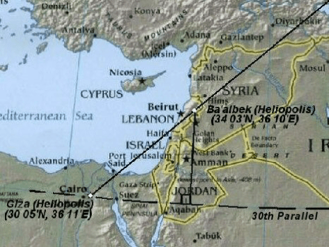
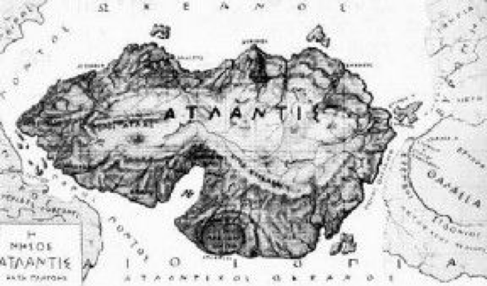
‘Secondly, and rather strikingly, The Greek lawmaker Solon visited Egypt around the year 600 BC and there he was told a very remarkable story by the priests at the Temple of Sais in the Nile Delta – a story that was eventually handed down to his more famous descendant Plato, who in due course shared it with the world in his Dialogues of Timaeus and Critias. It is, of course, the story of the great lost civilization of Atlantis swallowed up by flood and earthquake in a single terrible day and night nine thousand years before Solon’s visit to Egypt – in other words in 9,600 BC, or 11,600 years before the present’ – refer article: Antartica: Secrets of the Lost Continent of Atlantis

‘Since that date (give or take a margin of error of a few decades) coincides with Meltwater Pulse 1B and is accepted by geologists as the “official” end of the last Ice Age – the end of the “Pleistocene” epoch and the beginning of our current epoch, the “Holocene” – it is intriguing, to say the least, that it coincides so precisely with the date that Plato gives us for the destruction, and submergence beneath the sea, of the lost civilization of Atlantis. Also striking is the fact that 9600 BC is the date established by the German Archaeological Institute for the foundation of the truly extraordinary megalithic site of Gobekli Tepe in Turkey’ – refer article: Monoliths of the Nephilim. ‘For the full significance of Gobekli Tepe see Graham Hancock’s book Magicians of the Gods. 

While the impact of comet fragments on the North American ice cap 12,800 years ago is now strongly supported by the mass of evidence reviewed in this article as the cause of the beginning of the Younger Dryas, there is much less clarity over what caused the end of the cold interval and the renewed flooding and warming of 11,600 years ago… very radical climate changes occurred at both the onset and the termination of the Younger Dryas. In both cases these changes were global and were accomplished within the span of a human generation… the comet hypothesis helps to make sense of this. 

The estimated combined explosive force of the impacts would have lofted sufficient ejecta into the atmosphere 12,800 years ago to plunge the earth into a long, sustained twilight, akin to a nuclear winter – the “time of darkness” that so many ancient myths speak of – capable of reducing solar radiation for more than 1,000 years. The dramatic warming that began 11,600 years ago would then be explained by the final dissipation of the ejecta cloud coupled with an end to the system-wide inertia that had beset thermohaline circulation in the North Atlantic. 

Another possibility, not necessarily mutually contradictory with any of the above mechanisms, is that 11,600 years ago the earth interacted for a second* time with the debris stream of the same fragmenting comet that had caused the beginning of the Younger Dryas 12,800 years ago. This is by no means implausible since the earth still passes through that debris stream twice a year.

It is the well-known Taurid meteor stream, now 30 million kilometers wide. Travelling at around 2.5 million kilometers a day on its orbital path, our planet passes through the Taurid stream for around 12 days at the end of June and again for 12 days in late October and early November. At both transits, meteorites – “shooting stars” – in huge numbers enter and are usually small enough to burn up in our atmosphere (in October/November they are often referred to as the “Halloween Fireworks”). 

That sounds harmless enough but, as long ago as 1990, before any of the physical, geological evidence for the Younger Dryas comet impacts had been discovered, astrophysicist Victor Clube and astronomer Bill Napier warned of the view: “that treats the cosmos as a harmless backdrop to human affairs, a view which Academe now often regards as its business to uphold and to which Church and State are only too glad to subscribe.” Such a view, in Clube and Napier’s prescient 1990 opinion, is dangerous in that its effect is to “place the human species a little higher than the ostrich, awaiting the fate of the dinosaur.” 

As can be seen from the reactions of some members of “Academe” to the Younger Dryas impact hypothesis, this view, and what Clube and Napier call the “great illusion of cosmic security” that it engenders, are still powerful forces in the world today. Much more than the truth about our own past is at stake, however, for there is a chilling convergence between Clube and Napier’s findings on the one hand, and the findings of Kennett, West and Firestone on the other, as to what the Younger Dryas comet really means for humanity. 

To understand the implications of this convergence properly it will be necessary to review some of the discoveries made by Clube, Napier and others in the 1980’s and 1990’s – discoveries… that are completely independent of the later work of the Kennett/West/Firestone team on the Younger Dryas impacts… the burden of these discoveries is that it is possible – indeed highly probable – that we are not yet done with the comet that changed the face of the earth 12,800 years ago.

Clube and Napier’s work, with important contributions also from the late Sir Fred Hoyle, and from mathematician Emilio Spedicato and astronomer Professor Chandra Wickramsinghe, obliges us to consider the chilling possibility that the Younger Dryas comet was itself only a fragment of a much larger, giant comet – once perhaps as much as 100 kilometers in diameter – which entered the inner solar system about 30,000 years ago and was captured by the sun and flung into an earth-crossing orbit.’ 

Or as is even just as probable, comet fragments trailing a ninth planet. A planet which traverses a 3,600 year elliptical orbit around the Earth – refer Chapter XXII Alpha & Omega; and article: The Pyramid Perplexity. The role of the mysterious Nibiru as enumerated in Sumerian texts and latterly labelled Planet X by astronomers, will hopefully be the subject of a future article. 

‘It remained relatively intact for the next 10,000 years. Then around 20,000 years ago it underwent a massive “fragmentation event” somewhere along its orbit that transformed it from a single deadly and potentially world-killing object into multiple objects grading down from 5 kilometers to 1 kilometer or less in diameter, each and every one of which would still, in its own right, be capable of causing a global cataclysm. The astronomers believe it was several fragments on this scale that hit the earth 12,800 years ago, causing the Younger Dryas, and that we can expect further encounters with the remaining fragments in the future. “This unique complex of debris,” write Clube and Napier, “is undoubtedly the greatest collision hazard facing the Earth at the present time.” 

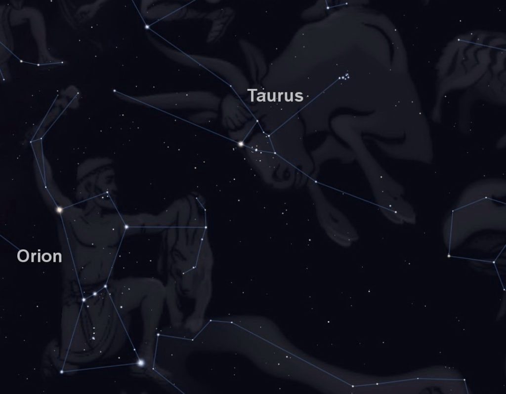
‘The Taurid meteor stream, so called because its showers of “shooting stars” look to observers on the ground as though they originate in the constellation of Taurus, is the most familiar and best-known product of the ongoing fragmentation of the original giant comet’ – refer Chapter XV The Philistines: Latino-Hispano America; and article: The Calendar Conspiracy.

‘As Clube, Napier, Hoyle and Wickramsinghe have demonstrated, however, the Taurid stream also contains other much more massive material, sometimes visible, sometimes shrouded in clouds of dust, and all of it flying through space at tremendous velocities and intersecting the Earth’s orbit twice a year, regular as clockwork, year in year out. Amongst these massive, deadly members of the Taurid family are Comet Encke, which is estimated to have a diameter of around five kilometers. But Comet Encke is not alone.’

‘According to Clube and Napier there are also: “between one and two hundred asteroids of more than a kilometer diameter orbiting within the Taurid meteor stream. It seems clear that we are looking at the debris from the breakup of an extremely large object. The disintegration, or sequence of disintegrations, must have taken place within the last twenty or thirty thousand years, as otherwise the asteroids would have spread around the inner planetary system and be no longer recognizsable as a stream.”

‘In addition to Comet Encke, there are at least two other comets in the stream – Rudnicki, also thought to be about five kilometers in diameter, and a mysterious object named Oljiato, which has a diameter of about 1.5 kilometers. Initially believed to be an asteroid, this extremely dark, Earth-crossing projectile sometimes shows signs, visible in the telescope, of volatility and outgassing and most astronomers now regard it as an inert comet that is in the process of waking up. Comet Encke itself is known to have been inert for a long period, until it suddenly flared into life and was first seen by astronomers in 1876. It is now understood to alternate regularly, in extended cycles, between its inert and volatile states.

Clube and Napier’s research had convinced them that an as yet undetected companion to Comet Encke is orbiting amidst clouds of harmless dust at the very heart of the Taurid meteor stream. They believe that this object is of exceptional size, that it is a comet, and that like Encke and Oljiato it sometimes – for very long periods – shuts itself down. This happens when pitch-like tars that seethes up continuously from its interior during episodes of outgassing become so copious that they coat the entire outer surface of the nucleus in a thick, hardening shell and seal it off completely – perhaps for millennia. On the outside all falls silent after the incandescent “coma” and tail have faded away and the seemingly inert object tears silently through space at a speed of tens of kilometers per second. But, at the center of the nucleus, activity continues, gradually building up pressure. Like an overheated boiler with no release valve, the comet eventually explodes from within, breaking up into fragments that can become individual comets every one of which threatens the Earth.

Calculations indicate that this presently invisible object at the heart of the Taurid stream might be as much as 30 kilometers in diameter. Moreover, it is thought likely that other large fragments accompany it. According to Professor Emilio Spedicato of the University of Bergamo: “Tentative orbital parameters which could lead to its observation are estimated. It is predicted that in the near future (around the year 2030) the Earth will cross again that part of (the Taurid meteor stream) that contains the fragments, an encounter that in the past has dramatically affected mankind” – Article: The Great Reset & the Fourth Industrial Revolution.

‘With this warning that an ancient enemy poses a real and present danger to the near and immediate future of civilization, let us return to the Younger Dryas and the possibility, after the first encounter 12,800 years ago, that the earth interacted for a second time with some large and dangerous comet fragments orbiting in the Taurid stream. On this hypothetical second occasion, however, the scenario proposed by the astronomers suggests that the primary impacts were not on land, or onto ice, but into the world’s oceans throwing up vast plumes of water vapour and creating a “greenhouse effect” that caused global warming rather than global cooling.’ 

This is a plausible explanation for the secondary flooding. The invisible object of exceptional size within the Taurid meteor stream may well turn out to be Planet X and its trailing comets and meteors the initial cause of the Younger Dryas epoch. The threat ascribed to the Taurid stream is real and may well have a role in a future impact event – articles: Antartica: Secrets of the Lost Continent of Atlantis; The Pyramid Perplexity; and Chapter XXII Alpha & Omega

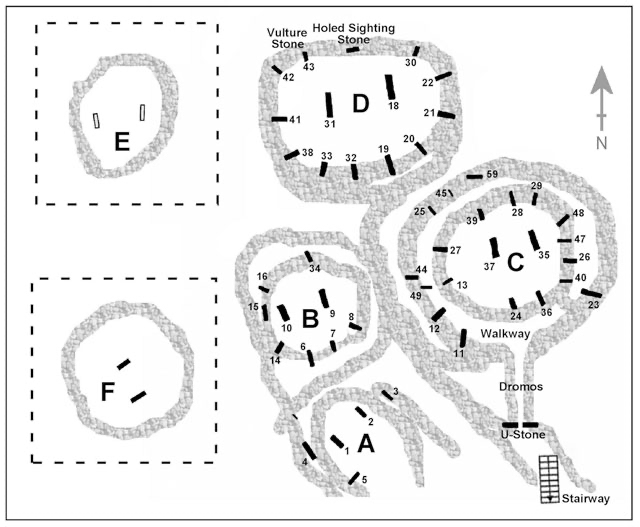
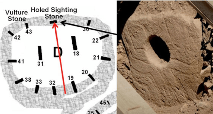
With that in mind, Martin Sweatman quoted earlier, refers to Pillar 43 at Gobekli Tepe and its association with the Taurid meteor stream – Decoding GÖBEKLI TEPE with Archaeoastronomy: What does the Fox say? Martin B Sweatman and D Tsikritsis (pages 233-250):

‘We have interpreted much of the symbolism of Göbekli Tepe in terms of astronomical events. By matching low-relief carvings on some of the pillars at Göbekli Tepe to star asterisms we find compelling evidence that the famous ‘Vulture Stone’ is a date stamp for 10950 BC ± 250 yrs, which corresponds closely to the proposed Younger Dryas event, estimated at 10890 BC. We also find evidence that a key function of Göbekli Tepe was to observe meteor showers and record cometary encounters. Indeed, the people of Göbekli Tepe appear to have had a special interest in the Taurid meteor stream, the same meteor stream that is proposed as responsible for the Younger-Dryas event. Is Göbekli Tepe the ‘smoking gun’ for the Younger-Dryas cometary encounter, and hence for coherent catastrophism?’ – refer article: Monoliths of the Nephililm.

Allied with a comet strike in North America, is an alternative explanation of one in adjacent Greenland. A massive crater hides beneath Greenland’s ice, Carolyn Gramling, November 14, 2018: ‘Whether the impact is related to a period of cooling called the Younger Dryas is unknown. There’s something big lurking beneath Greenland’s ice. Using airborne ice-penetrating radar, scientists have discovered a 31-kilometer-wide crater – larger than the city of Paris – buried under as much as 930 meters of ice in northwest Greenland. The meteorite that slammed into Earth and formed the pit would have been about 1.5 kilometers across… That’s large enough to have caused significant environmental damage across the Northern Hemisphere, a team led by glaciologist Kurt Kjær of the University of Copenhagen reports November 14 in Science Advances

Although the crater has not been dated, data from glacial debris as well as ice-flow simulations suggest that the impact may have happened during the Pleistocene Epoch, between 2.6 million and 11,700 years ago. The discovery could breathe new life into a controversial hypothesis that suggests that an impact about 13,000 years ago triggered a mysterious 1,000-year cold snap known as the Younger Dryas.

Members of the research team first spotted a curiously rounded shape at the edge of Hiawatha Glacier in northwest Greenland in 2015, during a scan of the region by NASA’s Operation IceBridge… it is not only the first crater found in Greenland, but also one of the 25 or so largest craters yet spotted on Earth. And it has held its shape… from its elevated rim to its bowl-shaped depression. “It’s so conspicuous in the satellite imagery now,” says John Paden, an electrical engineer at the University of Kansas in Lawrence and a member of the team. “There’s not another good explanation.”

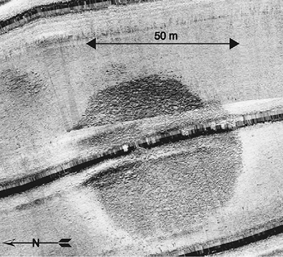
The image above shows the topography under the site at Hiawatha glacier, mapped with airborne radar data. Black triangles and purple circles are elevated peaks around the rim and centre. Dotted red lines and black circles show locations of additional sampling.

‘On the ground, the team hunted for geochemical and geologic signatures of an asteroid impact within nearby sediments. Sampling from within the crater itself was impossible, as it remains covered by ice. But just beyond the edge of the ice, meltwater from the base of the glacier had, over the years, deposited sediment. The scientists collected a sediment sample from within that glacial outwash and several from just outside of it. The outwash sample contained several telltale signs of an impact: “shocked” quartz grains with deformed crystal lattices and glassy grains that may represent flash-melted rock. The sample also contained elevated concentrations of certain elements, including nickel, cobalt, platinum and gold, relative to what’s normally found in Earth’s crust. That elemental profile points not only to an asteroid impact, the researchers say, but also suggests that the impactor was a relatively rare iron meteorite. 

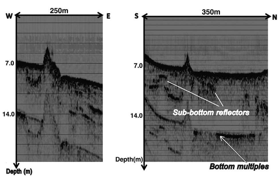
The ice-penetrating radar data revealed that the crater bowl itself contains several distinct layers of ice. The topmost layer shows a clear, continuous sequence of smaller layers of ice, representing the gradual deposits of snow and ice through the most recent 11,700 years of Earth’s history, known as the Holocene. At the base of that “well-behaved” layer is a distinct, debris-rich layer that has been seen elsewhere in Greenland ice cores, and is thought to represent the Younger Dryas cold period, which spanned from about 12,800 to 11,700 years ago. Beneath that Younger Dryas layer is another large layer – but unlike the Holocene layer, this one is jumbled and rough, with undulating rather than smooth, nearly flat smaller layers.’ 

“You see folding and strong disturbances,” says study coauthor Joseph MacGregor, a glaciologist with Operation IceBridge. “And below that, we see yet deeper, complex basal ice.” Radar images of that bottommost ice layer within the crater show several curious peaks, which MacGregor says could represent material from the ground that got incorporated into the ice. “Putting that all together, what you have is a snapshot of an ice sheet that looked fairly normal during the Holocene, but was quite disturbed before that.” 

‘Those data clearly suggest that the impact is at least 11,700 years old… And the rim of the crater appears to cut through a preexisting ancient river channel that must have flowed across the land before Greenland became covered with ice… That time span – essentially, the entire Pleistocene Epoch – is a large range. The team is working on further narrowing the possible date range, with more sediment samples, simulations of the rate of ice flow and possibly cores collected from within the crater. The date range does include the possibility that the impact occurred near the onset of the Younger Dryas. “It’s the woolly mammoth in the room,” MacGregor says.’ 

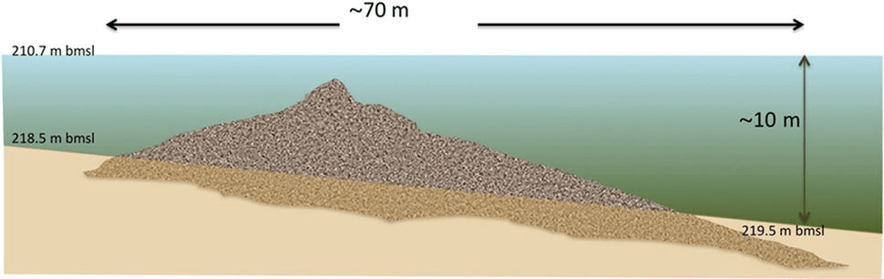
In a followup article entitled: Greenland may have another massive crater hiding under its ice, February 12, 2019, Carolyn Gramling states: ‘Greenland’s ice may be hiding more than one crater left by long-ago meteorite impacts. An analysis of satellite and airborne images of the topography beneath the ice sheet has revealed a large, craterlike structure buried beneath two kilometers of ice. It’s just 183 kilometers southeast of Hiawatha… The newfound bowl-shaped object is about 36.5 kilometers across, slightly larger than the 31-kilometer-wide Hiawatha depression, researchers report online February 11 in Geophysical Research Letters

Like Hiawatha, the new feature consists of a ring-shaped rim surrounding a depression with a peak at its center – consistent with a crater carved out by the impact of a large meteorite, says coauthor Joseph MacGregor, a glaciologist with NASA’s Operation IceBridge. Without more direct geologic data, scientists can’t… determine whether the two might be related to the same event. “It’s simply not that unusual,” says coauthor William Bottke, a planetary scientist at the Southwest Research Institute in Boulder, Colorado. Scientists already know of two such pairs – one in Ukraine and another in Canada – but, statistically, a third pair is plausible too, Bottke says.’ 

As Above So Below: Do the Giza Monuments encode the date of the Younger Dryas comet impact? Graham Hancock, December 10, 2014: ‘… it is possible that some fragments may have hit Egypt and this raises an intriguing speculation concerning the ancient Egyptian cult of the Benben stone. As long ago as 1989 my friend and colleague Robert Bauval proposed in the academic journal “Discussions in Egyptology” that the original Benben stone might have been an oriented iron meteorite… it is worth re-opening this discussion… whether the mysterious object worshipped in the Mansion of the Phoenix in Heliopolis might in fact have been a fragment of the Younger Dryas comet that caused the global cataclysm of 12,800 years ago’ – refer article: Monoliths of the Nephilim. ‘Like the Phoenix, comets are objects that return again and again to our skies and it is conceivable that some fragments of the Younger Dryas comet remain in orbit and might even threaten us today.’

Such speculations add new light to the strange correlation of sky and ground that memorialises the sky of 12,800 years ago in the giant monuments of Egypt’s Giza plateau where the priesthood of Heliopolis practised their star religion. I propose that this religion – the title of the High Priest of Heliopolis was “Chief of the Astronomers” – had its origins in a lost civilisation destroyed during the Younger Dryas cataclysm, and that survivors of that civilisation settled in Egypt and created a message to the future written in the language of astronomy and monumental architecture that was designed to draw attention to the exact epoch of the comet impact. 

The ancient Egyptians called the Milky Way the “Winding Waterway”. The constellation of Orion was seen as the celestial image of the god Osiris, said to have brought the gifts of civilisation to Egypt in the remote past in the epoch called Zep Tepi, “the First Time.”

‘The graphic [above] indicates the sky over Giza as it would looked early in the precessional “Age of Leo” (the period of roughly 2,160 years – between approximately 12,970 years ago and 10,810 years ago) when the constellation of Leo “housed” the sun on the Spring Equinox. Because of the phenomenon known as the precession of the equinoxes, each of the 12 zodiacal constellations takes it’s turn to house the sun during the course of “Great Year” which lasts a total of 12 X 2,160 years, i.e. 25,920 years. The alignment indicated in the graphic therefore only recurs every 25,920 years.’ 

The likelihood of a rogue planet within our Solar System and a trailing retinue of perhaps more than one comet and accompanying meteors being responsible for igniting the Younger Dryas, is in this writer’s view a persuasive argument. What may be quite astonishing is to learn the possible identity of the mysterious comet in question. Immanuel Velikovsky discusses an unintentional solution in his book Worlds in Collision, first published in 1950. 

His premise: that the second planet from the Sun Venus, began its life as a moon of Jupiter. It was deviated away from the gravitational pull of the biggest planet in our Solar System by another large, though not as big, planetary body as it hurtled past in close range. Venus became an unwitting comet and after a dangerous encounter with planet Earth – which he believed to be at the time of the Exodus from Egypt- finally rested in its current orbit between Mercury and Earth. This then would explain – what still alludes scientists – the reason for why Venus spins on its axis from east to west (that is, backwards or clockwise) and not from west to east like every other planet, excepting Uranus – refer Chapter XXII Alpha & Omega

Velikovsky says when Venus positioned itself in our Solar System it possessed a tail and moved on a not yet circular orbit, acting more like a comet than a planet. It was called a “smoking star” by the ancient Mexicans. He states: ‘The tails of comets are composed mainly of carbon and hydrogen gases. Lacking oxygen, they do not burn in flight, but the inflammable gases, passing through an atmosphere containing oxygen, will be set on fire. If carbon and hydrogen gases, or vapor of a composition of these two elements, enter the atmosphere in huge masses, a part of them will burn, binding all the oxygen available at the moment…’ Velikovsky provides considerable information regarding Venus, which ties in with information we have covered previously – refer article: Monoliths of the Nephilim; and Chapter XXII Alpha & Omega. It is relevant towards its role as a comet possibly around 13,000 years ago. 

‘When Venus had a coma, the horns of its crescent must have been extended by the illuminated portions of the coma. It thus had two long appendages and looked like a bull’s head. Sanchoniathon says that Astarte (Venus) had a bull’s head. The planet was even called Ashteroth-Karnaim, or Astarte of the Horns, a name given to a city in Canaan in honor of this deity. The golden calf worshiped by Aaron and the people at the foot of Sinai was the image of the star’ – Article: The Calendar Conspiracy; and Chapter XXVII Abraham & Keturah – Benelux and Scandinavia

‘Rabbinical authorities say that “the devotion of Israel to this worship of the bull is in part explained by the circumstance that, while passing through the Red Sea, they beheld the celestial Throne, and most distinctly of the four creatures [Cherubim] about the Throne, they saw the ox.” The likeness of a calf was placed by Jeroboam in Dan, the great temple of the Northern Kingdom’ – Article: Monoliths of the Nephilim; and Chapter XXXIV Dan: The Invisible Tribe. ‘Tistrya of the Zend-Avesta, the star that attacks the planets, “the bright and glorious Tistrya mingles his shape with light moving in the shape of a golden-horned bull.” The Egyptians similarly pictured the planet and worshiped it in the effigy of a bull. The cult of a bull sprang up also in Mycenaean Greece. A golden cow head with a star on its brow was found in Mycenae, on the Greek mainland.’ 

It is worth mentioning in the book of Ezekiel, Cherubim are described, including their faces. Ezekiel 10:14, ESV: “And every one had four faces: the first face was the face of the cherub, and the second face was a human face, and the third the face of a lion, and the fourth the face of an eagle.” The Hebrew word for Cherub is H3742 – kruwb, meaning an ‘angelic being’ – Article: The Ark of God; and Chapter XXII Alpha & Omega. While most translations use the word cherub, angel or guardian, some use the word Ox or Bull. 

Velikovsky: ‘The long horns of Venus could have been seen without the aid of a telescopic lens. The horns were the illuminated portions of the coma of Venus, which stretched toward the earth. These horns could also have extended toward the sun as Venus approached the solar orb, since comets were repeatedly observed with projections in the direction of the sun, while the tails of the comets are regularly directed away from the sun. When Venus approached close to one of the planets, its horns grew longer: this is the phenomenon the astrologers of Babylon observed and described when Venus neared Mars. “It is well known that not a few passages in the cuneiform texts on astrology speak of the right or the left horn of Venus. It was deduced that the phases of Venus were observed already by the Babylonians and that Galileo, in the sixteenth century, was not the first to see them.” Schaumberger, “Die Homer der Venus” in Kugler…’

‘In every country of the ancient world we can trace cosmo-logical myths of the birth of the planet Venus. If we look for the god or goddess who represents the planet Venus, we must inquire which among the gods or goddesses did not exist from the beginning, but was born into the family. The mythologies of all peoples concern themselves with the birth only of Venus, not with that of Jupiter, Mars, or Saturn. Jupiter is described as heir to Saturn, but his birth is not a mythological subject. Horus of the Egyptians and Vishnu, born of Shiva, of the Hindus, were such newborn deities. Horus battled in the sky with the monster-serpent Seth; so did Vishnu. In Greece the goddess who suddenly appeared in the sky was Pallas Athene. She sprang from the head of Zeus-Jupiter. In another legend she was the daughter of a monster, Pallas-Typhon, who attacked her and whom she battled and killed. 

The slaying of the monster by a planet-god is the way in which the peoples perceived the convulsion of the pillar of smoke when the earth and the comet Venus disturbed each other in their orbits, and the head of the comet and its tail leaped against each other in violent electrical discharges. 

The Greek authors described the birth of Athene (planet Venus), saying she sprang from the head of Jupiter. “And mighty Olympus trembled fearfully… and the earth around shrieked fearfully, and the sea was stirred, troubled with its purple waves.” One or two authors thought that Athene was born of Cronus [Saturn]. But the consensus of ancient authors makes Athene-Venus the offspring of Jupiter: she sprang from his head, and this birth was accompanied by great disturbances in the celestial and terrestrial spheres. 

The comet rushed toward the earth, and it could not be very well distinguished whether the planet Jupiter or its offspring was approaching. I may divulge here something that belongs to the second book of this work; namely, that at an earlier time, Jupiter had already caused havoc in the planetary family, the earth included, and it was therefore only natural to see in the approaching body the planet Jupiter. 

… modern theory… ascribes the birth of the terrestrial planets to the process of expulsion by larger ones. This appears to be true in the case of Venus. The other modern theory, which ascribes the origin of comets of short period to expulsion by large planets, is also correct: Venus was expelled as a comet and then changed to a planet after contact with a number of members of the solar system. Venus, being an offspring of Jupiter, bore all the characteristics known to men from early cataclysmic encounters. When a ball of fire tore the pillar of cloud and pelted the pillar with thunderbolts, the imagination of the people saw in this the planet-god Jupiter-Marduk rushing to save the earth by killing the serpent-monster Typhon-Tiamat.  

It is not strange, therefore, that, in places as remote from Greece as the islands of Polynesia, it is related that “the planet Jupiter suppressed the tail of the great storm.” But we are told that in the same places, notably on the Harvey Islands, “Jupiter was often mistaken for the Morning Star.” On other islands of Polynesia, “the planets Venus and Jupiter seem to have been confused with each other.” Explorers found “that the name Fauma or Paupiti was given to Venus… and that the same names were given to Jupiter.” 

‘Early astronomy shared Ptolemy’s opinion that “Venus has the same powers” and also the nature of Jupiter [as a former moon of Jupiter], an opinion reflected also in the astrological belief that “Venus, when she becomes sole ruler of the event, in general brings about results similar to those of Jupiter.” In one local cult in Egypt the name of Isis… originally belonged to Jupiter, Osiris being Saturn. In another local cult Amon was the name for Jupiter. Horus originally was also Jupiter. But when a new planet was born of Jupiter and became supreme in the sky, the onlookers could not readily recognize the exact nature of this change. They gave the name of Isis to the planet Venus, and sometimes the name of Horus. This must have caused confusion. “One is confused by the various relations which exist between mother and son (Isis and Horus). Now he is her consort, now her brother; now a youth… now an infant fed at her breast.” 

“A noteworthy representation shows her in association with Horus as the Morning Star, and thus in a strange relation… which we cannot yet explain from the texts.” Also Ishtar of Assyria-Babylonia was in early times the name of the planet Jupiter; later it was transferred to Venus, Jupiter retaining the name of Mardulc. Baal, still another name for Jupiter, was an earlier name for Saturn, and later on became the name of Venus, sometimes the feminine form Baalath or Belith [of Sidon] being used. Ishtar, also, was at first a male planet, subsequently becoming a female planet’ – Articles: Lilith; The Calendar Conspiracy; and Monoliths of the Nephilim.

“Ishtar, the fearful dragon,” wrote Assur-banipal. The Morning Star of the Toltecs, Quetzal-cohuatl (Quetzal-coatl), also is represented as a great dragon or serpent: “cohuatl” in Nahuatl is “serpent,” and the name means “a feathered serpent.” The Morning Star of the Indians of the Chichimec tribe in Mexico is called “Serpent cloud”, a remarkable name because of its relation to the pillar of cloud and the clouds that covered the globe after the contact of the earth with Venus. When Quetzal-cohuatl, the lawgiver of the Toltecs, disappeared on the approach of a great catastrophe and the Morning Star that bore the same name rose for the first time in the sky, the Toltecs “regulated the reckoning of the days, the nights, and the hours according to the difference in the time.” 

The Morning-Evening Star Ishtar was called also “the star of lamentation.” The Persian Mithra, the same as Tistrya, descended from the heavens and “let a stream of fire flow toward the earth,” “signifying that a blazing star, becoming in some way present here below, filled our world with its devouring heat.” In Aphaca in Syria fire fell from the sky, and it was asserted that it fell from Venus: “by which one would think of fire that had fallen from the planet Venus.” The place became holy and was visited each year by pilgrims. The festivals of the planet Venus were held in the spring. “Our ancestors dedicated the month of April to Venus,” wrote Macrobius.’

‘Baal of the Canaanites and of the Northern Kingdom of Israel was worshiped in Dan, the city of the cult of the calf, and throngs visited there during the week of Passover. The cult of Venus spread to Judea also. According to II Kings (23:5), King Josiah in the seventh century “put down the idolatrous priests, whom the kings of Judah had ordained to burn incense in the high places in the cities of Judah, and in the places round about Jerusalem; them also that burned incense unto Baal, to the sun, and to the moon, and to the planets, and to all the host of heaven.” Baal, the sun, the moon, and the planets, is the division used also by Democritus: Venus, the sun, the moon, and the planets. In Babylonia the planet Venus was distinguished from other planets and worshiped as a member of a trinity: Venus [Ishtar (Lilith)], Moon [Ba’al (Samael)], and Sun [Apollos (Azazel)]’ – Articles: Arius, Alexander & Athanasius; and Monoliths of the Nephilim. ‘This triad became the Babylonian holy trinity in the fourteenth century before the present era.

In the Vedas the planet Venus is compared to a bull: “As a bull thou hurlest thy fire upon earth and heaven” … [Jezebel], wife of Ahab, made her the chief deity of the Northern Kingdom. The women of Jerusalem made cakes for the queen of heaven [actually Asherah and not Ishtar] and worshiped her from the roofs of their houses. 

On Cyprus it was neither Jupiter nor any other god but “Kypris Queen whom they with holy gifts were wont to appease… pouring libations out upon the ground of yellow honey.” Such libation, as already mentioned, was made in Athens in commemoration of the Flood of Deucalion.’ 

The story of Deucalion and Pyrrha is the Greek version of the biblical Flood and Noah’s Ark, as told in the Roman poet Ovid’s, The Metamorphoses. Zeus the king of the gods, resolved to destroy all of humanity and so Deucalion constructed an ark in which he and his wife rode out the flood and landed on Mount Parnassus. 

Velikovsky: ‘The planet Venus was Lux Divina, the Divine Light, in the worship of the Roman imperial colonies – Isaiah 14:12 [H1966 Heylel: ‘shining one, light-bearer, morning star, lucifer’]. In Babylonia, Venus was pictured as a six-pointed star – which is also the shape of David’s shield – or as a pentagram – a five-pointed star (seal of Solomon) – and sometimes as a cross; as a cross it was pictured in Mexico, too. 

The attributes and deeds of the Morning Star were not invented by the peoples of the world: this star shattered mountains, shook the globe with such a violence that it looked as if the heavens were shaking, was a storm, a cloud, a fire, a heavenly dragon, a torch, and a blazing star, and it rained naphtha [a colourless, volatile petroleum distillate, usually an intermediate product between gasoline and benzine, used as a solvent or fuel] on the earth. Assurbanipal speaks of Ishtar-Venus, “who is clothed with fire and bears aloft a crown of awful splendor, (and who) rained fire over Arabia.”

‘In the attributes and in the deeds ascribed to the planet Venus  – Isis, Ishtar, Athene [Lilith]  – we recognize the attributes and deeds of the comet… Venus, of which it is said that “horns grew out of her head,” or… Venus cornuta, looked like the head of a horned animal; and since it moved the earth out of its place, like a bull with its horns, the planet Venus was pictured as a bull. The worship of a bullock was introduced by Aaron at the foot of Mount Sinai. The cult of Apis originated in Egypt in the days of the Hyksos, after the end of the Middle Kingdom, shortly after the Exodus. Apis, or the sacred bull, was very much venerated in Egypt; when a sacred bull died, its body was mummified and placed in a sarcophagus with royal honors, and memorial services were held.’ 

“All the coffins and everything excellent and profitable for this august god (the bull Apis)” were prepared by the Pharaoh, when “this god was conducted in peace to the necropolis, to let him assume his place in his temple.” The worship of a cow or bull was widespread in Minoan Crete and in Mycenaean Greece, for golden images of this animal with large horns were found in excavations’ – refer Chapter XV The Philistines: Latino-Hispano America. ‘Isis, the planet Venus, was represented as a human figure with two horns, like Astarte (Ishtar) of the horns; and sometimes it was fashioned in the likeness of a cow. In time, Ishtar changed from male to female, and in many places worship of the bull changed to worship of the cow. The main reason for this seems to have been the fall of manna which turned the rivers into streams of honey and milk. A horned planet that produced milk most closely resembled a cow. 

In the Hymns of the Aiharva-Veda, in which the ambrosia that falls from the sky is glorified, the god is exalted as the “great cow” which “drips with streams of milk”… A passage of the Ramayana about the “celestial cow” says: “Honey she gave, and roasted grain… and curled milk, and soup in lakes with sugared milk,” which is the Hindu version of “rivers of milk and honey.” The “celestial cow” or “the heavenly Surabhi” (“the fragrant”) was the daughter of the Creator: she “sprung from his mouth”; at the same time nectar and “excellent perfume” were spread, according to the Indian epic. This description of the birth of the daughter from the mouth of the Creator is a Hindu parallel of Athene [Venus (Lilith)] springing from the head of Zeus [Jupiter (Lucifer/Samael*)].

Down to the present day, the Brahmans worship the cow. Cows are regarded as daughters of the “heavenly cow” [Kali (Asherah)]. In India, as in other places, the worship of cows began in some period of recorded history. “We find in early Hindu literature sufficient information to establish the thesis that cows were once victimised at sacrifices and used at times as articles of food.” Then came the change. Cows became sacred animals, and ever since the religious law has forbidden the use of their meat for food. The Atharva-Veda repeatedly deprecates cow-killing as “the most heinous of crimes.” “All that kill, eat or permit the slaughter of cows rot in hell for as many years as there are hairs on the body of the cow slain.”

Capital punishment was prescribed for those who either stole, hurt, or killed a cow. “Whoever hurts or causes another to hurt, or steals or causes another to steal, a cow, should be slain.” Even cows’ urine and dung are sacred to the Brahmans. “All its excreta are hallowed. Not a particle ought to be thrown away as impure. On the contrary, the water it ejects ought to be preserved as the best of holy waters… Any spot which a cow has condescended to honour with the sacred deposit of her excrement is forever afterwards consecrated ground.” Sprinkled on a sinner, it “converts him into a saint.” 

‘The bull is sacred to Shiva, “the god of destruction in the Hindu Trinity” [otherwise known as the Storm god and Baal Hadad*]. “The consecration of the bulls and letting them loose as privileged beings to roam at their will and draw respect from all people is to be noted with particular interest… The freedom and privileges of the Brahman bull are inviolate.” Even when it is destructive, the bull must not be restrained. These quotations show the Apis cult preserved until our times. The “celestial cow” that gored the earth with its horns and turned rivers and lakes into honey and milk is still revered in the common cow and bull by hundreds of millions of the people of India. 

The beautiful Morning Star was related to Ahriman, Seth, [and] Lucifer… It was also Baal of the Canaanites and of the Northern Kingdom of the Ten Tribes, the god hated by the biblical prophets, also Beelzebub or Baal Zevuv, or Baal of the fly.’ 

These three titles – Lucifer, Baal and Beelzebub – are descriptions of a being who is not Satan, the Adversary… but rather, the Serpent who was in the Garden of Eden – refer Samael: Chapter XXII Alpha & Omega.

‘In the Pahlavi text of the Iranian book, the Bundahis, describing the catastrophes caused by celestial bodies, it is written that at the close of one of the world ages “the evil spirit (Ahriman) went toward the luminaries.” “He stood upon one-third [Revelation 12:4] of the inside of the sky, and he sprang, like a snake, out of the sky down to the earth.” It was the day of the vernal equinox [March 20/21]. “He rushed in at noon,” and “the sky was shattered and frightened.” “Like a fly, he rushed out upon the whole creation, and he injured the world and made it dark at midday as though it were in dark night.’

Revelation 8:12, JBP: “… a third-part of the sun, a third-part of the moon and a third of the stars were struck. A third-part of the light of each of them was darkened, so that light by day and light by night were both diminished by a third-part.”

‘And noxious creatures were diffused by him over the earth, biting and venomous, such as the snake, scorpion, frog, and lizard, so that not so much as the point of a needle remained free from noxious creatures [Revelation 9:3, 10, 19; 16:13-14]. Then the Bundahis proceeds: “The planets, with many demons (comets), dashed against the celestial sphere, and they mixed the constellations; and the whole creation was as disfigured as though fire disfigured every place and smoke arose over it…” 

‘It is significant that all around the world peoples have associated the planet Venus with flies. In Ekron, in the land of the Philistines, there was erected a magnificent temple to Baal Zevuv, the god of the fly.’ A more accurate translation for Beelzebub is ‘Lord of the Fliers’ or ‘Lord of those who fly’ – Matthew 12:24, Mark 3:22, Luke 11:15. Thus Baal is the lord of dark angels and demonic spirits. Likewise, Venus is really associated with these same entities and not merely literal flies. 

‘In the ninth century King Ahaziah of Jezreel, after he was injured in an accident, sent his emissaries to ask advice of this god at Ekron and not of the oracle at Jerusalem – 2 Kings 1:2. This Baal Zevuv is Beelzebub of the Gospels – Luke 11:18-19, Matthew 10:25. Ahriman, the god of darkness who battled with Ormuzd, the god of light, is compared in the Bundahis to a fly. Of the flies that filled the earth buried in gloom it is said: “His multitudes of flies [demons] scatter themselves over the world that is poisoned through and through.”

‘Ares (Mars) in the Iliad calls Athene [Venus**] “dog-fly” – Isis** (Lilith) is the Dog Star (Sirius); refer article: The Pyramid Perplexity. “The gods clashed with a mighty din, and the wide earth rang, and round about great heaven pealed as with a trumpet.” And Ares spoke to Athene: “Wherefore now again, thou dog-fly, art making gods to clash with gods in strife?” The people of Bororo in central Brazil call the planet Venus “the sand fly,” an appellation similar to that which Homer used for Athene. The Bantu tribes of central Africa relate that the “sand fly brought fire from the sky,” which appears to be a reference to the Promethean role of Beelzebub, the planet Venus.’ 

While Beelzebub, Baal and Lucifer can be symbolised singularly by the planet Venus… when in reference to a trinity of gods; Baal is specifically Jupiter and it is in fact Ishtar, otherwise known as Lilith, who is more accurately represented by Venus. The third member of this specific trinity is Apollo, the Sun god – refer Azazel – Chapter XXI The Incredible Identity, Origin & Destiny of Nimrod; Chapter XXII Alpha & Omega; and article Monoliths of the Nephilim.

‘(Darmesteter), refers to worm-stars that “fly between the earth and heaven,” and that supposedly signify the meteorites. Possibly it is a reference to their infesting property’ and corroborated in Revelation 8:10-11, ESV: “The third angel blew his trumpet, and a great star fell from heaven, blazing like a torch, and it fell on a third of the rivers and on the springs of water. The name of the star is Wormwood [G894 – apsinthos: ‘bitterness, calamity’]. A third of the waters became wormwood, and many people died from the water, because it had been made bitter” – Chapter XXII Alpha & Omega.

‘This idea of contaminating comets is found in a belief of the Mexicans described by Sahagun: “The Mexicans called the comet citlalin popoca which means a smoking star… These natives called the tail of such a star citlalin tlamina, exhalation of the comet; or, literally, ‘the star shoots a dart.’ They believed that when such a dart fell on a living organism, a hare, a rabbit, or any other animal, worms suddenly formed in the wound and made the animal unfit to serve as food. It was for this reason that they took great care to cover themselves during the night so as to protect themselves from this inflaming emanation.”

‘The Mexicans thus thought that larvae from the emanation of the comet fell on all living things. Sahagun says also that at the rising of the Morning Star, the Mexicans used to shut the chimneys and other apertures in order to prevent mishap from penetrating into the house together with the light of the star. The persistence with which the planet Venus is associated with a fly in the traditions of the peoples of both hemispheres, also the emblems carried by the Egyptian priests and the temple services conducted in honor of the planet-god “of the fly,” create the impression that the flies in the tail of Venus were not merely the earthly brood, swarming in heat like other vermin, but guests from another planet. 

There exists an extensive exegetic literature on… Mazzaroth, from which it can be concluded only that “the meaning of Mazzaroth is uncertain.” But the Vulgate (Latin) translation of the Bible has Lucifer for Mazzaroth. The (Greek) translation of the Seventy (Septuagint) reads: “Canst thou bring forth Mazzaroth in his season and guide the Evening Star by his long hair?” These words of the Septuagint seem very strange… the Greek word komet means “the long-haired one,” or a star with hair, a comet. In Latin, coma is “hair.” Mazzaroth means a comet… and… Mazzaroth means Venus and a hairy star.’ – refer articles: Lilith; and The Pyramid Perplexity.

‘Venus ceased to appear in its seasons. What… happened? Venus [became the] Morning Star… [and] has followed an orbit between Mercury and earth, which it has maintained ever since. It became the Morning and Evening Star. Seen from the earth, it is never removed more than 48 degrees (when at its eastern and western elongation) or three hours and a few minutes east or west of the sun. The dreaded comet became a tame planet. It has the most nearly circular orbit among the planets.’

‘Venus in the night sky to the left of Betelgeuse, a variable red supergiant star of the first magnitude and second brightest in the Orion constellation. Its designation is α Orionis (Latinised to Alpha Orionis), given by Johann Bayer in 1603. The traditional name Betelgeuse was derived from the Arabic Yad al-Jawzā’ or ‘the hand of al-Jawzā’, that is, Orion. The name Betelgeuse – pronounced ‘beetlejuice’ – is not far removed from Beelzebub [aka, Ba’al Zebub, Belzebuth and Beelzebul].

The end of the terror… was the inspiration for Isaiah when he said: “How art thou fallen from heaven, O Lucifer, son of the morning! how art thou cut down to the ground, which didst weaken the nations! For thou hast said in thine heart, I will ascend into heaven, I will exalt my throne above the stars of God.” What does it mean, that the Morning Star was assailing the heavens and rising high, and that it was cut down low to the horizon, and would weaken no more the nations? More than a hundred generations of commentators have occupied themselves with this passage, but have met with failure.

Why… should the beautiful Morning Star, called Lucifer, the Light Bearer, live in the imagination of peoples as an evil power, a fallen star? What is in this lovely planet that makes her name an equivalent of… the dark power? After a great struggle, Venus achieved a circular orbit and a permanent place in the family of planets. During the perturbations which brought about this metamorphosis, Venus also lost its cometary tail. In the valley of the Euphrates, “Venus then gives up her position as a great stellar divinity, equal with sun and moon, and joins the ranks of the other planets.” A comet became a planet.’ 

The role of the goddess Venus – as Lilith and Ishtar – has been discussed previously, as has the planet Venus, which has the fascinating history of once being a moon of Jupiter; a comet of Nibiru; and now a permeant resident of our Solar System. What hasn’t been considered until now, is Venus’s role as the initiator of the Younger Dryas Stadial; terminator of the antediluvian age; and herald of the post-flood epoch in which we currently live. 

A striking coincidence is the Bull symbolism of the planet Venus and the origin of the Taurid Meteor stream in the Taurus constellation. Or is it? 

A fascinating occurrence in early 2020, when Venus was transposed with the Taurus constellation  

Bulls are mentioned numerous times in the scriptures. “Reprimand the beasts in the tall grass, the herds of bulls that are with the people’s calves…” – Psalm 68:30, The Voice. “Wild oxen shall fall with them, and young steers with the mighty bulls…” – Isaiah 34:7, ESV.

It is ironic that the hot debate on the Younger Dryas, is what caused it and in so doing, deflects from the most important element of the Younger Dryas – whether an ancient advanced civilisation with technology superior to our twenty-first century world, was destroyed.

Ancient Code reported on a massive study which included twenty-four researchers and was published in two scientific papers. ‘The study titled Extraordinary Biomass-Burning Episode and Impact Winter Triggered by the Younger Dryas Cosmic Impact ~12,800 Years Ago, analyzed geochemical and isotopic markers and found that massive fires would have been responsible, in part, for the disappearance of large mammals.’ The paper is divided into Part I: Ice Cores and Glaciers and Part II, Lake, Marine and Terrestrial Sediments. “The study includes measurements made at more than 170 different sites around the world,” said Adrian Melott, Professor Emeritus of Physics and Astronomy at the University of Kansas and one of the authors of the research. 

“The hypothesis is that a massive comet fragmented and the pieces hit Earth, generating this disaster,” said Melott. This impact would have caused fires so large that the resulting dust clogged the sky and prevented sunlight from entering. “A number of different chemical signatures – carbon dioxide, nitrate, ammonia, and others – seem to indicate that an astounding 10% of the earth’s surface, or about 10 million square kilometers, was consumed by fires.”

This may be an important component in the Earth’s demise, prior to the global inundation of flood waters. Imagine powerful earthquakes, multiple volcanic eruptions and widespread fires afflicting the people around the world – all before the massive hundred foot tidal waves swept the globe. 

An intriguing discovery revealing an ancient past which directly contradicts mainstream history for humankind are the Ica Stones of Peru – much like the Inga Stone in Brazil – Article: Monoliths of the Nephilim. The Ica Stones consist of a collection of thousands of stones discovered in modern-day Peru. The Ica Stones ‘depict humans coexisting with Dinosaurs, as well as numerous advanced technologies that should not have existed before written history… numerous laboratories have confirmed their existence… [as] extremely old.’

The stones were found in 1961 by farmers, beneath the sands of the vast desert of Ocucaje on the coast of the Department of Ica in Peru. The stones vary in size with different colours ‘ranging from gray, black, yellow and red.’ They are composed out of oxidised andesite. Carbon 14 studies conducted by the University of Madrid in 2003, determined that they are between 60,000 and 100,000 years old. It is proposed that an adjusted more accurate date, would be consistent with 6,000 to 10,000 years old instead. 

Ancient Code state: ‘The discovery of the Ica Stones is considered by many as one of the greatest controversies in the archaeological community… the enigmatic stones are the ultimate evidence which proves mankind coexisted with dinosaurs in antiquity…’ that is, at least in the antediluvian age and perhaps older, dating circa 11,000 to 36,000 BCE according to an Unconventional Chronology

‘This controversial timeline proposed by many researchers directly contradicts mainstream views on history yet seems to follow a pattern set by similar discoveries which oppose [current] views of history and human origins. 

The engravings on the Ica stones… [depict]… the reproductive cycle of a primitive fish without jaws… the process of blood transfusions performed on a pregnant woman… organ transplants (kidney, heart)… the application of anesthetic gas in a Caesarean section… the transplant of cerebral hemispheres, the use of electromagnetic energy, pyramids, space travel, men looking at the stars with binoculars, the study of ancient petroglyphs…’ 

‘Interestingly, the Ica Stones also depict 13 constellations: the traditional ones studied and observed by ancient cultures around the globe and the constellation of the Pleiades [found in the constellation of Taurus – refer article: The Pyramid Perplexity]. According to reports, the 13 constellations correspond to the Babylonian Zodiac, which observed the sky recording the passage of our planet through the universe… the Ica stones are yet another discovery that proves history as we know it is completely wrong. And as author, producer, and anthropologist specializing in linguistics, archeology, and paleobiology (archaeogenetics) Robert Sepehr… [said], mankind is a species with Amnesia.’ 

Even with an abundance of legends, myths and tales of a worldwide flood and a demise of an advanced arcane civilisation, there are those who smugly disdain those who try to encourage people to think for themselves and seek the truth on humanity’s past. 

One example is the article: No, There Wasn’t an Advanced Civilization 12,000 Years Ago – Did an advanced civilization disappear more than 12,000 years ago? by Michael Shermer, June 1, 2017 – emphasis and bold mine. In it he states: ‘Graham Hancock is an audacious autodidact who believes that long before ancient Mesopotamia, Babylonia and Egypt there existed an even more glorious civilization.’ 

An autodidact is “a person who has learned a subject without the benefit of a teacher or formal education; a self-taught person.” Yes, perish the thought that one drifts from relying on mainstream academia to lead the way for them and shine the light on what is factual, correct, accurate, right or true. They have proved time and time again that they can be relied upon to always provide an agenda free and honest discussion, correct? 

The word audacious means, “extremely bold or daring; recklessly brave; fearless, extremely original; without restriction to prior ideas; highly inventive.” Both these words are compliments when measured against the lies and deceit perpetrated by historians and scientists, but let’s continue with what Shermer has to say after the personal insult. 

‘One so thoroughly wiped out by a comet strike around 12,000 years ago that nearly all evidence of its existence vanished, leaving only the faintest of traces, including, Hancock thinks, a cryptic warning that such a celestial catastrophe could happen to us. All this is woven into a narrative entitled Magicians of the Gods (Thomas Dunne Books, 2015). I listened to the audio edition read by the author, whose British accent and breathless, revelatory storytelling style are confessedly compelling. But is it true? I’m skeptical.’

Well yes, one would be wouldn’t they? If they did not give any credence to a flood story recounted by hundreds of cultures around the world. And certainly, any prophetic warning as provided in the scriptures is laughable and to be ignored and ridiculed. Strange though, that the warning signs are available to science should they wish to remove the blinkers over their eyes, regarding the cyclical nature of devastating disasters. 

First, no matter how devastating an extraterrestrial impact might be, are we to believe that after centuries of flourishing every last tool, potsherd, article of clothing, and, presumably from an advanced civilization, writing, metallurgy and other technologies – not to mention trash – was erased? Inconceivable.’ 

Not inconceivable, if the all-consuming destructive power of moving flood water a hundred feet high and the complete annihilation of animal life, insect life, bird life and human life is truly comprehended. Sherman is like the ostrich which hides its head in the sand. Doing so, doesn’t negate the reality occurring out of sight.

Second, Hancock’s impact hypothesis comes from scientists who first proposed it in 2007 as an explanation for the North American megafaunal extinction around that time and has been the subject of vigorous scientific debate. It has not fared well. 

In addition to the lack of any impact craters determined to have occurred around that time anywhere in the world, the radiocarbon dates of the layer of carbon, soot, charcoal, nanodiamonds, microspherules and iridium, asserted to have been the result of this catastrophic event, vary widely before and after the megafaunal extinction, anywhere from 14,000 to 10,000 years ago.

Further, although 37 mammal genera went extinct in North America (while most other species survived and flourished), at the same time 52 mammal genera went extinct in South America, presumably not caused by the impact. These extinctions, in fact, were timed with human arrival, thereby supporting the more widely accepted overhunting hypothesis.’ 

Sherman is choosing to ignore the data supporting impacts in the northern hemisphere as well as splitting hairs on the time frame for the beginning of the Younger Dryas; which is a non-argument in regard to the existence of an advanced civilisation or not. The aspect of which animal species survived and didn’t is a feeble attempt to discredit, when it also does not have any bearing on whether an advanced civilisation collapsed or not – Chapter I Noah Antecessor Nulla

Third, Hancock grounds his case primarily in the argument from ignorance (because scientists cannot explain X, then Y is a legitimate theory) or the argument from personal incredulity (because I cannot explain X, then my Y theory is valid). This is the type of “God of the gaps” reasoning that creationists employ, only in Hancock’s case the gods are the “magicians” who brought us civilization.

The problem here is twofold: (1) scientists do have good explanations for Hancock’s X’s (for example, the pyramids, the Great Sphinx), even if they are not in total agreement, and (2) ultimately one’s theory must rest on positive evidence in favor of it, not just negative evidence against accepted theories.’ 

Sherman has successfully defined the formula practiced by investigators, whether a journalist or a police officer. Applying Occam’s razor leads to the either the simplest; the most logical; or the only explainable solution in an enquiry. Science dares not to tread down this path, if a lack of hard evidence is shadowed by circumstantial evidence. Whereas, this does not deter or inhibit a journalist and a detective. 

Scientists have incorrect explanations for the Giza pyramids and the Sphinx. They are incorrect on who built them and when they did. Thus a theory of an advanced civilisation does not have a ‘problem’, it is science that does. Likewise, the second problem is for science too, in that a theory has to be rock solid and provable ‘beyond all reasonable doubt’. It is not being ‘negative’ to show otherwise. Science’s answer for the evolution of humankind as a gradual upward curve has been shown to be full of holes and would not convince a judge and jury of its infallibility. 

‘Hancock’s biggest X is Göbekli Tepe in Turkey, with its megalithic, T-shaped seven-to 10-ton stone pillars cut and hauled from limestone quarries and dated to around 11,000 years ago, when humans lived as hunter-gatherers without, presumably, the know-how, skills and labor to produce them. Ergo, Hancock concludes, “at the very least it would mean that some as yet unknown and unidentified people somewhere in the world, had already mastered all the arts and attributes of a high civilization more than twelve thousand years ago in the depths of the last Ice Age and had sent out emissaries around the world to spread the benefits of their knowledge.” 

This sounds romantic, but it is the bigotry of low expectations. Who is to say what hunter-gatherers are or are not capable of doing? Plus, Göbekli Tepe was a ceremonial religious site, not a city – there is no evidence that anyone lived there. Moreover, there are no domesticated animal bones, no metal tools, no inscriptions or writing, and not even pottery-all products that much later “high civilizations” produced.’ 

Sherman reveals himself to be a bigot. Bigotry: “stubborn and complete intolerance of any creed, belief, or opinion that differs from one’s own.” Often the case when a person reduces themselves to name calling. The one point Michael Sherman is correct on, is the unlikelihood of ‘hunter-gatherers’ being the architects of Gobekjli Tepe – refer article: Monoliths of the Nephilim. These are dots Graham Hancock has not quite joined together. While Hancock is resilient enough to include the anathema word ‘Atlantis’ in his research, the next steps are ‘giants’ and the ‘Nephilim’. While Gobekli Tepe may not have been a ‘city’ as one would normally label; it was certainly a settlement which incorporated ceremonial features. Sherman with a little more research would know that evidence has been unearthed proving people did dwell there permanently and not just in a temporary capacity – Article: Monoliths of the Nephilim

Fourth, Hancock has spent decades in his vision quest to find the sages who brought us civilization. Yet decades of searching have failed to produce enough evidence to convince archaeologists that the standard timeline of human history needs major revision. Hancock’s plaint is that mainstream science is stuck in a uniformitarian model of slow, gradual change and so cannot accept a catastrophic explanation. Not true.’ 

But, from an evolutionary view for humankind this is true. Mainstream science is guilty as charged. 

‘From the origin of the universe (big bang), to the origin of the moon (big collision), to the origin of lunar craters (meteor strikes), to the demise of the dinosaurs (asteroid impact), to the numerous sudden downfalls of civilizations documented by Jared Diamond in his 2005 book Collapse, catastrophism is alive and well in mainstream science. The real magicians are the scientists who have worked this all out.’ 

The Big Bang as currently explained was not a collision per se, but an explosion of energy. Perhaps at the molecular level it can be argued to be a collision, but it is not a good example either way. The dinosaurs became extinct far more recently than science realises, with their demise actually supporting Hancock’s conclusions. ‘Catastrophism’ may be ‘alive and well in mainstream science’ but the ‘real magicians’ [are those] who propose its dramatic affect on mankind and the danger it poses for humanity’s future. ‘Scientists have [not] worked this all out’ at all.  

The Moon on the other hand is an interesting proposition. It appears that an ancient collusion if you will through a literal collision, occurred between the Moon and the Earth. The Moon is a body seemingly not even originating in this Solar System and any collisions or scarring on its surface have no bearing in this discussion, or so this writer thought – refer Chapter XXII Alpha & Omega.

A comment on Graham Hancock’s website caught the eye.

Kalopin, May 1, 2017:

‘Please… study further into this… The YDB ejecta blanket strewn field covered over four continents and reached extreme [temperatures] over 2200*C. Any form of life beneath this was instantly incinerated (vaporized)… The only source to exert this much energy, that contains enough mass, weight, volume, density, velocity, in orbit and enough electromagnetic repulsion, would be the Moon… 

During the Pleistocene there was less gravity, less electromagnetism, less ground-level radiation. Plants and animals grew much larger and lived much longer… megafauna, megaflora, including the dinosaurs and many highly intelligent civilizations thrived during this period…

The Moon was in a much closer and unstable orbit, as the weight of Pangaea… caused an imbalance, finally allowing the Moon to impact where the Mediterranean is, after releasing massive amounts of plasma at the Black sea, lofting many tonnes of rock from beneath the Tethys [Ocean], breaking apart the super-continent… 

At this same moment, exhuming massive amounts of deeper, colder limestone to form the Ozarks, pinching in the entire thickness of a tectonic plate inward forming the Mississippi embayment, and pushing the burnt surface material and rocks to form the Appalachias and this self-made springboard, along with a pole reversal (Gothenburg geomagnetic excursion) sent the Moon back out to a safer orbit, but not before curling the entire western edge of the plates upward, engulfing a couple of broken slabs, the Farallon and Nazca plates, forming the Rockies and Andes then releasing another massive amount of plasma to form the Grand canyon… All the mountainous anomalies throughout the southwest were formed by this impact, such as Devil’s tower and Kasha-Katuwe…

Chicxulub crater was once downtown Atlantis and stretches from Xibalba to out [past] the Bimini road…’ refer article: Antartica: Secrets of the Lost Continent of Atlantis. ‘The Sahara desert is the finer material (Libyan glass) from this impact. It [swivelled] the African plate at the southwestern edge of the Arabian plate and forced the Indian plate into Eurasia to form the Himalayas. Released Australia to the east, Antarctica to the south and released Madagascar on its way back, from tectonic rebound… 

When the Moon impacted it slowed the outer plates and mantle, in relation to the faster spinning, crystallized inner core, increasing electromagnetism, length of the day and gravity, along with producing more radiation, making it impossible for dinosaurs to exist and greatly reducing the size and lifespan of every living creature [including man]… The Moon is iron, much harder than Earth’s oceans and outer plates. It is the remnants, the crystallized iron inner core, from a once habitable planet, in a now defunct solar system that was traveling ahead of this one and whose star had went supernova, as this action is commonplace, as these inner cores have strong attractions to stars and inner solar systems… 

All this occurred in an instant, when the Moon impacted the Mediterranean sea 12,980 years ago. They have recently found a layer of platinum along with the iridium at the YDB… after the continents drifted to about where they are currently, a comet struck the Hudson bay, emptying out lake Agassiz, causing further sea-level rise, ending the Clovis period, destroying even more technology, science and history… which had accumulated up to the end of the Pleistocene… We are recovering from an extreme period of devolution… (until;-)’

Where to begin? Kalopin raises a number of interesting points. This writer has pondered the great length of human age in the antediluvian epoch. Yet not discovered a reasonable answer. A link between this anomaly of age, with gravity, electromagnetism, radiation and the Moon is intriguing. A Moon closer to Earth’s super continent fits with Pangea breaking up at the time of Noah and the flood – Chapter XXII Alpha & Omega. The geological and geographical changes are plausible and the repositioning of Antartica further south; though do not concur with Kalopin’s location for Atlantis – Article: Antartica: Secrets of the Lost Continent of Atlantis

Nor is this writer convinced the Moon collided with the Earth at this time. Its change to an orbit further away would still have impacted life on Earth as Kalopin describes, but may have been actuated by the fly by of Planet X and the near miss of the comet Venus in tow –  flinging the Moon away from Earth’s gravitational pull. Of interest, is the explanation of the Moon being the remnant of an inner iron core of a former planet. As the Moon is hollow, this lends credence to the Earth – and other planets – having at their very centre, a hollow core. The secondary cosmic hit whether a comet or not, would tally with the Comet Encke and Taurid Meteor stream hypothesis and the later flooding at the end of the Younger Dryas. 

An article by Mark Boslough of Skeptic, highlights (just a few) inconsistencies of the Comet Research Group and the YDIH. ‘Plagued by self contradictions, logical fallacies, basic misunderstandings, misidentified impact evidence, abandoned claims, irreproducible results, questionable protocols, lack of disclosure, secretiveness, failed predictions, contaminated samples, pseudoscientific arguments, physically impossible mechanisms, and misrepresentations, the YDIH has never been accepted by experts in any related field. The skepticism has increased following instances of questionable conduct by the Comet Research Group leaders…’ 

While the CRG may have acted to bring discredit on the YDIH, it does not negate the central tenant of their thesis. Detractors are quite happy in using these issues to deflect from the idea of the destruction of an advanced civilisation. 

‘… Hancock’s facts about sea level rise during the late Pleistocene are… wrong. There is no evidence that the world’s oceans rose dramatically in a series of deluges during the Younger Dryas. Hancock’s claim contradicts the sea level data collected around the world. For example, corals in Barbados recorded rates decreasing from 20 mm/year at 13,900 years BP (before 1950) to 4 mm/year 11,550 years BP.’

A ‘series of deluges’ is not accurate. As discussed, the initial flood in 10,837 BCE and a secondary lesser one at the termination of the Younger Dryas some 1,200 years later are viable. Thus a settling of water during this lengthy period is not unexpected and small decreases in millimetres not unusual or worthy to be used as examples to discredit an overall rise in sea level of one hundred metres as the graph above so clearly shows. 

‘In round numbers, the current rate of sea level rise is 4 mm/year (and rising), about the same as at the end of the Younger Dryas, a rate that many global warming deniers dismiss as too low to be concerned about or even to measure’ – refer article: Climate Change & Global Warming – Looming Crisis or a New Equilibrium? ‘Unfortunately for Hancock the rate of sea level rise during the Younger Dryas was lower than it was just before the Younger Dryas.’ 

This can be explained as discussed previously by the unusual weather patterns for approximately one hundred and twenty years before and including the onset of the deluge at the beginning of the Younger Dryas – Genesis 6:3. This included an increase in earthquakes, volcanic eruptions and the global warming of temperatures. 

Boslough concludes: ‘… Graham Hancock’s Ancient Apocalypse has many of the attributes of pseudoscience: rejection of the scientific method, extraordinary claims without extraordinary (or even ordinary) evidence, dismissal of contrary evidence, contempt for recognized subject matter experts, unfalsifiable claims, confirmation bias, and lack of peer review.’ 

Of course what Boslough and every critic neatly fail to mention, is that Hancock is not a scientist, geologist, archaeologist, engineer or historian and does not claim to be any of these. Graham Hancock is an investigative journalist highlighting holes in the current teaching about Mankind’s ancient past. Hancock claims ancient myths are memories of real events and that humanity is suffering from amnesia about its past without realising. It is true, one does not know they are living in deception until they become aware that they are deceived. Hancock is merely blowing the whistle the loudest on the subject. Scientists don’t like it because if true, they have a massive revision of history to tackle and humble pie to eat. They are not going to permit a ‘pseudoscientist’ to embarrass them in this way. 

‘Nevertheless, some skeptics might conclude that the one scientifically viable element of Ancient Apocalypse is the hypothesis that a swarm of comet fragments triggered a global catastrophe at just the right time by colliding with the Earth.’ 

Well, that is surely a vital piece of the Younger Dryas puzzle? And Mark Boslough readily admits the most important matter of all… that Hancock may have a point. 

‘As well, and given the fact that peer review is fallible, it is my professional opinion that the YDIH should also be viewed by skeptics with suspicion. Virtually all experts, working independently in the relevant fields, who have stated their opinions about the YDIH, have expressed skepticism. The negative scientific consensus that emerged very quickly after the first peer-reviewed publication introduced the YDIH 15 years ago has not changed.’ 

So why the continued obstinance in accepting a collision or collisions as the ignition for the cataclysm at the beginning of the Younger Dryas? 

Considering Venus as a possible suspect in the Younger Dryas cataclysm, the following comments regarding comets on Hancock’s website are of interest. 

Ioannis Demetriades, May 3, 2017:

‘I have to apologise Mr Hancock. It is not your fault that you repeat this non-sense. There is no evidence that a comet or a piece of comet ever hit the Earth in the past and so we cannot make comparisons with proxy evidence (nano-diamonds). It is a physical impossibility for a comet to hit the Earth. First it is the region they inhabit and the trajectories of comets and second their composition. They are made of loose material (surprisingly little ice)… The Tunguska incident was not proved to be a comet that exploded before hitting the earth (no evidence). The comet Shoemaker-Levy 9 that plunged into Jupiter first broke into pieces (due to tidal forces) and then exploded before reaching the surface. Most comets are caught by larger planets before they reach the inner small planets. The only extra terrestrial objects that hit the earth in the past and today are mainly meteorites (because they are composed mainly of iron) and asteroids made of rock and if they are small say less than 100 Metres in diameter they explode before they reach the surface (maybe Tunguska?). Please do not misunderstand me I do not suggest for a minute that the Younger Dryas incident was not by an extra-terrestrial object hitting the Earth all I am saying it could not be a comet.’ 

Graham Hancock:

‘You need to educate yourself on the science before making abrupt and insulting remarks about my work. It’s simply a matter of looking at the evidence, much of which is set out in my article which you do not appear to have read. Follow up the references to all the papers published since 2007. Of course there is opposition to the Younger Dryas Impact Hypothesis but the evidence is mounting fast… and in my humble opinion the detractors, including yourself, are going to end up looking rather silly… I never said a comet of 200 kms diameter HIT the earth. The evidence is that a giant comet approaching that size entered the solar system 20,000 or 30,000 years ago and began, as most comets do (eg Shoemaker Levy 9) to break up into multiple fragments. Around 12,800 years ago some of these fragments (maximum size 1 to 2 kms diameter) hit the earth with the epicenter on the North American ice cap. There may have been further impacts 11,600 years ago. And more impacts during the Bronze Age. The Tunguska event in 1908 was likely another fragment out of the debris trail of the same comet. That debris trail, including several massive objects such as Comets Encke, Oljiato and Rudnicki is still on an earth-crossing orbit and we pass through it twice a year. It’s called the Taurid meteor stream. Its likely that most of the mass of the original giant comet is still aloft in the stream.’

Ioannis Demetriades, May 9, 2017:

‘I apologise if I caused any offense. It was not my intention. I like your work. I admit I used some harsh words. There are still arguments about the chemical composition of Comets. There is not enough data. Comet ISON showed that it is composed of loose rock material. There was not much ice observed on ISON but after the impact and surprisingly explosion; analysis showed Methanol, Formaldehide, H-Cyanide, Acetyline etc. i.e. Organic materials that produce water (after the interaction with ionising Solar wind) that is observed in the tail of most comets not a trace of Platinum (joke). There is no analysis available for the rocky material. It is a conjecture that asteroids in Taurid shower are cometary fragments; they may or may not be (such conclusions will be irresponsible and not scientific). We do not really know the composition of the comets and any theories regarding them is mainly a conjecture. If you look closely at the referred publication the detected Platinum is not conclusively from a comet. It says “Cometary or meteoric influx” – Platinum points to a meteorite (not even an asteroid) but it “proves” (I must see all the data regarding Platinum) that a large extraterrestrial object hit the Earth at that time (younger Dryas) although the samples shown on the map… seem very few to be conclusive, that is if they refer to the same event. By studying proxy materials on earth will not tell us anything about their origin since we do not know the composition of the comets… you mention of supposedly the original comet was a gigantic 200 km that broke up. That is pure conjecture by the scientists involved. They should be taken to task by an authorised astronomical committee. Publicising in journals is not good enough. Today’s peer review leaves a lot to be desired.’ 

If the cosmic debris pelting the Earth in the past was not a comet per se, then fragments from previous collisions involving Planet X and its trail of meteors is a viable alternative option. The larger body within the Taurid meteor stream which passes Earth bi-annually – as opposed to Nibiru’s 3,600 year circuit around Earth – is unlikely to be Planet X.

The Ancient Apocalypse eighth and final episode, Cataclysm and Rebirth, was particularly interesting and discussed evidence for a great deluge at the beginning of the Younger Dryas. The sites discussed included the Channelled Scablands and the Missoula Floods. 

Online Encyclopaedia: The Missoula floods, known as the Spokane floods, the Bretz floods or Bretz’s floods are described as ‘cataclysmic glacial lake outburst floods that swept [supposedly] periodically across eastern Washington [rather than once] and down the Columba River Gorge at the end of the last ice age.’ The Channeled Scablands are a barren soil-free region of ‘interconnected relict and dry flood channels, coulees and cataracts eroded into Palouse loess and the typically flat-lying basalt flows that remain after cataclysmic floods within the southeastern part of Washington state. The Channeled Scablands were scoured by [supposedly] more than [80] cataclysmic floods [rather than one] during the Last Glacial Maximum.’ 

Graham Hancock discusses these sites at length on his website. We will hit the high points. For those readers interested in the whole article, the link is:

https://grahamhancock.com/hancockg17/ 

Hancock: ‘In March 2017 the National Geographic Society and the Smithsonian Institution, those bastions of scientific orthodoxy, highlighted the remarkable achievements of two scientific rebels, one retired and the other deceased, confessing that multiple injustices had been done to both and that the “toxic” way in which they had been treated by their professional colleagues had “poisoned” scientific progress… for National Geographic the rebel of choice in 2017 was US geologist J. Harlen Bretz, condemned to pariah status in the 1920’s for daring to propose that a gigantic flood had scoured the “scabland” of America’s Pacific Northwest near the end of the last Ice Age. It was an idea that contradicted the consensus view of scientists at the time that geological transitions were always slow and gradual – a view in which there was no place for sudden and cataclysmic earth changes. Bretz died in 1981… [and was] ultimately proved right.’ 

‘Here is Bretz, writing in 1928 after one of his field trips across Washington State in the Pacific Northwest of the US: 

“No one with an eye for landforms can cross eastern Washington in daylight without encountering and being impressed by the “scabland.” Like great scars marring the otherwise fair face of the plateau are these elongated tracts of bare, or nearly bare, black rock carved into mazes of buttes and canyons. Everybody on the plateau knows scabland. It interrupts the wheat lands, parcelling them out into hill tracts less than 40 acres to more than 40 square miles in extent. One can neither reach them nor depart from them without crossing some part of the ramifying scabland. Aside from affording a scanty pasturage, scabland is almost without value. The popular name is an expressive metaphor. The scablands are wounds only partially healed – great wounds in the epidermis of soil with which Nature protects the underlying rock.

With eyes only a few feet above the ground the observer today must travel back and forth repeatedly and must record his observations mentally, photographically, by sketch and by map before he can form anything approaching a complete picture. Yet long before the paper bearing these words has yellowed, the average observer, looking down from the air as he crosses the region, will see almost at a glance the picture here drawn by piecing together the ground-level observations of months of work. The region is unique: let the observer take the wings of the morning to the uttermost parts of the earth: he will nowhere find its likeness.”

Graham Hancock with catastrophist Randall Carlson at Dry Falls – a fossilised waterfall of enormous size cut by the waters of Bretz’s flood and left as seen now when the flood had run its course 

Hancock: ‘… when he saw huge numbers of erratics – giant boulders that didn’t belong naturally in the area but had clearly been brought in from elsewhere – he was inclined to assume that they might have travelled here in icebergs carried on some great glacial flood. This impression was strengthened when he explored Grand Coulee and Moses Coulee – gigantic channels gouged deeply in the earth – and visited the Quincy Basin at the southern end of Grand Coulee where he found the whole 600-square-mile depression filled up to a depth of 400 feet with small particles of basalt debris. He couldn’t help but wonder, “where had all the debris come from, and when?” Again the answer that presented itself to him was a flood.’ 

A colossal glacial erratic perched high up on the valley side above the town of Wenatchee, Washington State, was laid to rest above in an iceberg the size of an oil tanker and carried on a raging flood hundreds of feet deep.

‘Bretz was… in the Scablands in 1923 for three months of exploration and it seems to have been during this field trip that his later views – namely that “some spectacular hydrological event… had begun in this region, then abruptly stopped”, really began to take shape. Bretz was an eminently rational man, and certainly no religious dogmatist, yet, as his biographer John Soennichsen notes, “while hiking through the hot, dry, ragged world of the Scablands, everything he had seen pointed not to a slow, uniform change over time but to a catastrophe, a sudden release of colossal quantities of water that had quickly washed away the loessial topsoil and then carved deeply into the basalt rock beneath.” 

Bretz noted in his 1923 paper: “The writer confesses that during ten weeks of study of the region, each newly examined scabland tract reawakened a feeling of amazement that such huge streams could take origin from such small marginal tracts of an ice sheet, or that such an enormous amount of erosion, despite high gradients, could have resulted in the very brief times these streams existed. Not River Warren, nor the Chicago outlet, not the Mowhawk channel, nor even Niagara Falls and Gorge itself approach the proportions of some of these scabland tracts and their canyons. From one of these canyons alone (Upper Grand Coulee) 10 cubic miles of basalt was eroded by its glacial stream.”

‘Concluding the paper, and moving towards the profoundly heretical and anti-uniformitarian idea that would soon get him into a great deal of trouble, namely that a single cataclysmic flood sustained only for a very short period had been responsible for all the devastation he had witnessed, Bretz wrote:

“Fully 3,000 square miles of the Columbia plateau were swept by the glacial flood, and the loess and silt cover removed. More than 2,000 square miles of this area were left as bare, eroded, rock-cut channel floors, now the scablands, and nearly 1,000 square miles carry gravel deposits derived from the eroded basalt. It was a debacle which swept the Columbia Plateau.” In other words, as Bretz’s biographer summarizes, the geologist now believed that the features he had documented “could only have been created by a flood of unimaginable proportions, possibly the largest flood in the history of the world” – refer Chapter I Noah Antecessor Nulla.

‘The reaction of the geological establishment was one of stunned, embarrassed silence. To have strayed so far from the doctrine of uniformitarianism could only mean that Bretz must have gone mad. David Alt, Professor Emeritus of Geology at the University of Montana, describes one of the lectures that Bretz gave in which he expounded on the ideas in his 1923 paper:

“The geologists… were aghast in the same way that a roomful of physicists would be upon hearing a colleague explain how he had made a perpetual motion machine out of old popsicle sticks. Physicists had all learned very early of the futility of perpetual motion machines, and no properly educated geologist was supposed to traffic in catastrophes of any sort.” 

‘To this day, most geologists consider it nothing less than heresy to invoke a catastrophic explanation for a geologic event. So Bretz stepped off the edge of a very long limb when he suggested that a great flood had eroded the Scablands… (It made) him a pariah among geologists, an outcast from the politer precincts of society. 

James Gilluly, well known as an apostle of geologic gradualism, dismissed the notion of a single cataclysmic flood with words like “preposterous”, “incompetent”, and “wholly inadequate”. He found nothing in Bretz’s evidence to exclude his own preferred solution, namely that multiple smaller floods had been involved… Likewise G.R. Mansfield doubted that “so much work could be done on basalt in so short a time… The Scablands seem to me better explained as the effects of persistent ponding and overflow of marginal glacial waters, which changed their position or their places of outlet from time to time through a somewhat protracted period.” O.E. Meinzer was obliged to confess that “the erosion features of the region are large and bizarre” but he, too, preferred a gradualist explanation: “Before a theory that requires a seemingly impossible quantity of water is fully accepted, every effort should be made to account for the existing features without employing so violent an assumption…” 

‘In summary, not a single voice was raised in support of Bretz and there was much patronizing dismissal of his “outrageous hypothesis” of a single large flood. In particular, the massed geologists homed in on what they clearly believed was the fatal flaw in the case for a sudden and overwhelming cataclysm – namely that Bretz had failed to identify a convincing source for his floodwaters. Bretz replied that he saw no logic in this, since lack of a documented source for the flood did not prove that there had been no flood. “I believe that my interpretation of channeled scabland should stand or fail on the scabland phenomena themselves,” he argued.

He was, he said, as sensitive as anyone else to adverse criticism, and had “no desire to invite attention simply by advocating extremely novel views.” Moreover, he himself had repeatedly been driven to doubt “the verity of the Spokane Flood”, only to be forced “by reconsideration of the field evidence, to use again the conception of enormous volume… These remarkable records of running water on the Columbia Plateau, and in the valleys of the Snake and Columbia Rivers, cannot be interpreted in terms of ordinary river action and ordinary valley development… Enormous volume, existing for a very short time, alone will account for their existence.” In the final analysis, however, they could not disprove his science, only disapprove of it, which is a very different thing.’ 

Therefore today, contrary to all the evidence, Gradualism and Uniformitarianism have won out as the theories ascribed to the violent topography of the Scablands and the outpouring of water from Lake Missoula. The literal interpretation of Catastrophism for the Scablands condition has been neatly compartmentalised into a series of mini catastrophes, not a great singular catastrophe at all really. Phew, that releases scientists from ever having to concede that a global flood afflicted the Earth as recorded in the scriptures. What else might one find in the Bible that is problematic and uncomfortable for mainstream academia to acknowledge, one wonders? 

Hancock: ‘While the impact of comet fragments on the North American ice cap 12,800 years ago is now strongly supported by the mass of evidence reviewed in this article as the cause of the beginning of the Younger Dryas, there is much less clarity over what caused the end of the cold interval and the renewed flooding and warming of 11,600 years ago. [Robert] Schoch makes an interesting contribution to the debate… and he might ultimately be vindicated in his proposal that it was “solar outbursts and accompanying catastrophic cataclysms” that caused the abrupt ending of the Younger Dryas around 11,600 or 11,700 years ago. On the other hand it is also perfectly possible that [Fred] Hoyle will be vindicated and that comet impacts are implicated not only at the beginning but also at the end of the cold episode.’

‘More research certainly needs to be done to establish the exact mechanisms, in all their complexity, that brought about the sudden termination of the Younger Dryas, but the effects on global climate are already well understood. Just as much as the events of 12,800 years ago, the events of 11,600 years ago were, as J Harlen Bretz might have put it, “a debacle”. Could it be that those events, with North America standing squarely at their epicenter, were indeed the final straw that destroyed a great advanced civilization of prehistoric antiquity?’ 

‘As we’ve seen, all the old archaeological certainties regarding the peopling of the Americas have now been thrown out with the recognition that Clovis was very far from being “first”. Perhaps the lost civilization that I have spent the last quarter of a century trying to track down had its most significant outpost, possibly even its heartland, in North America in the period BEFORE the Younger Dryas cataclysms of 12,800 to 11,600 years ago?’ 

Yes, that is an interesting surmising. Did Noah and his family live on the North American continent? Or perhaps even in Atlantis, as geological evidence shows Antartica was once joined with North America – Article: Antartica: Secrets of the Lost Continent of Atlantis

Mark Boslough whom we quoted earlier, expresses his opinion regarding Hancock’s and Carlson’s theories on the Scablands: ‘As a subject matter expert in impact physics and planetary defense, it is my professional opinion that Graham Hancock misrepresents science in claiming that there is a strong “what’s called uniformitarian trend” in geology. Ironically, he makes that assertion while discussing the Channeled Scablands, for which the widely accepted geological explanation is a series of catastrophic floods from ice dam collapses that released water from the enormous prehistoric Lake Missoula. Regarding this event, at least, geologists are catastrophists.’ 

Well, this was only achieved through foul play, by besmirching Bretz’s findings. Calling geologists catastrophists in regard to the Scablands, is a long stretch. Admitting a series of flood episodes does not reflect the evidence for a single cataclysm and is fudging at best and downright dishonest at worst.

‘Nevertheless, Hancock goes on to say that “modern geologists” don’t like cataclysms very much. Not so. It was a modern geoscientist named Gene Shoemaker who proved that Meteor Crater in Arizona and Ries Crater in Bavaria were created by asteroid impacts. And another named Walter Alvarez was one of the leaders of the team that discovered the impact event that wiped out the dinosaurs. Modern geologists embrace cataclysms fully… when there is evidence for them.’ 

If only it were that simple. They like catastrophes, if they can place extraordinarily long dates in the past for them. And only if it stays clear of any relation to a cataclysmic event which too closely parallels the biblical flood it would seem. Nor are they very open to a more recent cyclical nature of passing asteroids, meteors, comets and planets which pose a real threat of collision in the future. 

‘Unfortunately, in his Netflix series, Hancock doesn’t interview any scientists or subject matter experts about impact physics or geology.’ 

How many of them agree? Or, how many of them would want to be interviewed publicly?

‘Instead, he asks amateur geologist and author Randall Carlson to weigh in on his unorthodox speculations that the professionals don’t know what they are talking about, haven’t properly identified the source of floodwaters, and that the water actually came from the Arctic ice cap.’ 

It doesn’t seem the professionals do know what they are talking about. Recent generations of scientists and geologists have become indoctrinated in believing in a series of floods over a long period as the answer to the Scablands formation, so that they now don’t see what is clearly before them. Have any of these professionals actually studied and visited the Scablands?  

‘Carlson also thinks that the floods are not as old as geological dating demonstrates, and are really a single event that happened at the onset of the Younger Dryas.’ 

In this instance, this writer would agree with the free thinker, whether he is an amateur or not. The Scablands is perhaps one of the best examples of the agenda ridden academic community advancing an evolutionary explanation, for an occurrence which clearly supports an ancient non-evolutionary event. 

An interesting phenomena is the evidence provided by what are called Black Mats (below). They are strata of organic-rich soil that have been identified at about fifty archaeological sites across North America. They are significant in that they support a bolide impact. Bolide means: ‘a large, brilliant meteor, especially one that explodes; a fireball.’

Encyclopaedia: ‘Using statistical analysis and modeling, James P. Kennett and others concluded that widely separated organic-rich layers, including black mats, were deposited synchronously across multiple continents as an identifiable Younger Dryas boundary layer. In 2019, Jorgeson and others tested this conclusion with the simulation of radiocarbon ages. They accounted for measurement error, calibration uncertainty, “old wood” effects, and laboratory measurement biases, and compared against the dataset of radiocarbon ages for the Laacher See eruption. They found the Laacher See 14C dataset to be consistent with expectations of [synchronicity]. They found the Younger Dryas boundary layer 14C dataset to be inconsistent with the expectations for its [synchronicity], and the synchronous global deposition of the hypothesized Younger Dryas boundary layer to be extremely unlikely.’ 

Yes, bet they did. As Carbon 14 dating is unreliable past four thousand years ago, this writer remains sceptical about the new results. Either way, whether dating matches the flooding of the Younger Dryas or the volcanic activity approximately one hundred years earlier, it still creates a flashing neon arrow sign marker for a cataclysmic event like no other in the historical record of Homo sapiens

At Arizona’s Murray Springs, an organic clay layer, or black mat (above), dating to around 12,800 years ago, sits on top of deposits containing Clovis artifacts and skeletons of large game; with some researchers saying the layer holds markers of an extraterrestrial impact.

In a previous article, the likelihood of another ice age occurring was discussed and the fact that the Earth is not experiencing global warming at all, but rather under going global cooling – refer article: Climate Change & Global Warming – Looming Crisis or a New Equilibrium? An article in the Sun Newspaper, entitled: CHILLING PREDICTION Planet Earth could be heading for an ICE AGE as face of The Sun ‘goes blank’, by Jasper Hamill, October 3, 2016, states: 

‘Climate experts issue terrifying warning which will literally send shivers down every human’s spine. The Sun has “gone blank” and it could herald the arrival of an Ice Age… This chilling prediction is based on analysis of the solar surface, which is currently exhibiting a distinct lack of action. Normally, the face of our parent star is pocked by sunspots. 

But it’s looking as smooth as a billiard ball… and sunspots are appearing at the lowest rate for 10,000 years as solar activity slows down… Space Weather… said there were more blank suns to come. “There will be lots of spotless suns. At first, the blank stretches will be measured in days; later in weeks and months. The current blank spell is the 4th such interval of 2016, so far.” 

‘It is feared the lack of sunspot activity could prompt the arrival of a cold snap similar to the Maunder Minimum, which [began] in 1645 and continued to about 1715. This period is known as the Little Ice Age and became famous for the winter frost fairs held on the frozen surface of the Thames River. Last year [2015], Professor Valentina Zharkova suggested a similar episode could hit Earth in the 2030s. She said the Sun’s activity would drop by up to 60% during the next mini Ice Age, potentially causing crop failures and other minor disasters down here on Earth.’ 

“I am absolutely confident in our research. It has good mathematical background and reliable data… In fact, our results can be repeated by… researchers… in… solar observatories, so they can derive their own evidence… in solar magnetic field and activity.”

A single bloom of the alpine wildflower Dryas octopetala in a high valley in the Orjen Mountains of Montenegro.

And there were flashes of lightning, rumblings, peals of thunder, and a great earthquake such as there had never been since man was on the earth, so great was that earthquake… and the cities of the nations fell… 

Revelation 16:18-19 English Standard Version

… a great earthquake shook the earth and the sun grew dark and became black (like mourning sackcloth) and the full moon became red like blood. The stars of heaven fell to earth as a fig tree drops its fruit during a winter storm. 

Revelation 6:12-13 The Voice

“It is perfectly obvious that the whole world is going to hell. The only possible chance that it might not is that we do not attempt to prevent it from doing so.”

J Robert Oppenheimer 

© Orion Gold 2024 – All rights reserved. Permission to copy, use or distribute, if acknowledgement of the original authorship is attributed to orion-gold.com

Monoliths of the Nephilim

This writer particularly enjoyed researching a recent article concerning unexplained mysteries and was surprised at not only how much satisfaction was gained in putting it together, but also the level of interest shown by readers – Article: The Top Ten Unexplained Mysteries of all Time. In a similar vein, an article by Ancient Code, entitled: Five Archaeological discoveries no one can explain, April 2022, is the inspiration for this article. We will investigate the same five discoveries, of which three of them this writer wasn’t even aware. As with the previous article where two additional mysteries to the original ten were included; it is hoped to add two further discoveries of considerable interest to the five we will study – the equally intriguing sites of Sacsayhuaman in Peru and Baalbek in Lebanon.

We have touched upon the Giza Pyramids and the Sphinx previously, though it is the intention to write an in-depth article on both of these enigmas in the future – refer articles: The Pyramid Perplexity; and Appendix VII: Moses, the Exodus & the Red Sea Crossing – Fabrication or Fact? Like wise, briefly mentioned were the hidden settlement at altitude of Machu Picchu, or the ‘Lost City of the Incas’ situated high up in the Andes Mountains in Peru, as well as the giant buried statues on Easter Island – Chapter XXVII Abraham & Keturah – Benelux & Scandinavia

What these structures have in common is an advanced intricacy of design, construction and purpose as well as being monuments of monolithic proportions, seemingly, or rather more pointedly, glaringly out of place within the orthodox paradigm presented for the world in which we live. This article logically follows Antartica: Secrets of the Lost Continent of Atlantis. As the legacy of the antediluvian epoch is reflected in the gigantic structures built in the age after the global cataclysm in 10,837 BCE according to an unconventional chronology – refer article; The Younger Dryas Stadial: Ending of the Earth… Beginning of the World.

Ancient Code: ‘All over the world, experts have found countless puzzling monuments, artifacts, and places that have remained a mystery ever since their discovery… these findings literally rewrite history as we know it. Countless theories have been proposed throughout the years trying to explain… them, however, not even the best scholars can agree on the purpose, reason and building process of… these… structures… we [will] take a look at FIVE discoveries that still continue to baffle experts.’ 

I. Massive Stone Mound beneath the Sea of Galilee 

Beneath the Sea of Galilee in northern Israel lays a conical structure comprised of ‘unhewn basalt cobbles and uncut boulders.’ Its weight is estimated to be 60,000 tons (heavier than most modern warships), rising nearly thirty-two feet (10m), with a diameter of approximately two hundred and thirty feet (70) – longer than the length of a Boeing 747. Owen Jarus, Live Science, April 9, 2013, states: ‘To put that in perspective, the outer stone circle of Stonehenge has a diameter just half that with its tallest stones not reaching that height.’ 

A reoccurring theme in the structures we will investigate is the baffling question of how the builders ‘managed to transport the megalithic blocks of stone. The closest basalt outcrop was a few hundred metres from the site. The stones used are one to two metres in width and weigh up to two hundred pounds [90 kg].’

This shot of the Sea of Galilee was taken near the old city of Tiberias. The newly discovered structure is located just to the south

‘Archaeologists argue that judging by what they have been able to see, its builders belonged to a “complex and well-organized society”…’ The structure looks like a giant rock cairn (rocks piled on top of each other) used to mark burials. Whether this was its intended purpose is open to question. It was first detected in 2003 from a sonar survey off the southwest portion of the sea, located some five hundred meters (1600 ft) off the coast and nine meters under the surface. Divers who investigated the structure, wrote in the International Journal of Nautical Archaeology:

“Close inspection by scuba diving revealed that the structure is made of basalt boulders up to 1 m (3.2 feet) long with no apparent construction pattern,” the researchers write in their journal article. “The boulders have natural faces with no signs of cutting or chiselling. Similarly, we did not find any sign of arrangement or walls that delineate this structure.” Their opinion is that it was built on land and covered as the water level rose. “The shape and composition of the submerged structure does not resemble any natural feature. We therefore conclude that it is man-made and might be termed a cairn.” 

The use of Compressed High Intensity Radar Pulse (CHIRP) provided researchers with additional information; indicating its “western face is somewhat steeper than the eastern part.”

Jarus adds: ‘Researchers list several examples of megalithic structures found close to the Sea of Galilee that are more than 4,000 years-old. One example is the monumental site of Khirbet Beteiha, located some 19 miles (30 kilometers) north-east of the submerged stone structure… It “comprises three concentric stone circles, the largest of which is 56 m [184 feet] in diameter.” This dating is conservative, with the cairn likely being far older. Underwater archaeological excavation is required in the hope of finding artefacts which could assist in determining the structure’s date and its purpose.

On our journey, there has been a mysterious common thread regarding circular monuments – where we can now add cones – which are ‘strangely, intriguingly, consistently and uniquely, replicated in the layout of Stonehenge; Plato’s account of the geographic configuration of Atlantis; crop circles; the rings of both Saturn; and the recently discovered, Super Saturn’ – Chapter XXII Alpha & Omega; and article, Antartica: Secrets of the Lost Continent of Atlantis.

During the third millennium BCE, the city of Bet Yerah (or Khirbet Kerak), was one of the biggest sites in the vicinity – located about a mile to the south of Galilee’s cone shaped mound – with researcher Yitzhak Paz saying: “It… [was] the most powerful and fortified town in this region and, as a matter of fact, in the whole of [ancient] Israel.” 

A rock cairn comprises a human-made pile or stack of rough stones raised for a purpose. Either as a marker of some kind, such as a landmark; a memorial; a monument; a ceremonial ground; or as a prehistoric burial mound. Typically found on a hilltop or skyline, they can also be a navigational aid. ‘The word cairn stems from the Scottish Gaelic: càrn [ˈkʰaːrˠn̪ˠ] (plural càirn [ˈkʰaːrˠɲ] ).’ 

As this structure is sizeable, it may not be a burial ground, just as pyramids are not tombs. Its stature signifies a monument designed to be a. seen; b. remembered; and c. lasting. While the Galilee Mound is not as intricately sophisticated in its design, it still required considerable effort in its construction. Archeologists agree that the monument was of great importance to the people who built it.

II. The Cochno Stone 

A coincidence arises in that as the word cairn is from the Scottish Gaelic, the next unexplained archaeological mystery is the Cochno Stone in the foothills of the Kilpatrick Hills of West Dunbartonshire in Scotland. It is a short walk from the Faifley housing estate and a twenty minute drive from Glasgow.

The Cochno Stone is an enigmatic slab of sandstone discovered in 1887 by the Reverend James Harvey. When the stone was discovered, it remained buried for decades to protect it from vandalism. 

Interest in the site was ignited ‘in the 1930s when an account of the site in the Proceedings of the Society of Antiquaries of Scotland caught the attention of the eccentric and tireless amateur archaeologist Ludovic Maclellan Mann. He had already undertaken various excavations of Bronze Age sites in and around Glasgow and had a particular interest in the cosmological meaning of prehistoric rock art. In 1937, the profusion of weird symbols on the Cochno stone inspired in him a burst of well meaning but questionable creativity: he painted the rock surface in various colours. He picked out the cup-and-ring marks in white and covered the stone in a spectacular yellow linear grid of his own devising to try and capture its original cosmological and geometric meaning’ – The Conversation, September 14, 2016.

The huge gritstone outcrop is domed in the middle and features about ninety carefully carved indentations – consisting of domes, lines and rings across an area of almost 100 square metres – considered to be one of the finest petroglyph sets not just in Scotland, but in the world. ‘A petroglyph is an image created by removing part of a rock surface by incising, picking, carving, or abrading, as a form of rock art.’ The Cochno Stone has been conservatively dated to five thousand years old, though an older origin is probable. The name Cochno means ‘little cups’ in Gaelic and it is also known as ‘the Druid Stone’ or Whitehill 1.

Ludovic Mann [right] and a colleague studying the site in the 1930s

The Conversation continues: ‘Mann’s work brought media attention to the stone and soon visitors came flocking. Over the next couple of decades, their numbers kept increasing as urban Glasgow crept closer. By the early 1960s, the Cochno stone had become a popular place for local people and children to hang out. There was a growing fashion for visitors to carve marks and names into the soft rock, and lots of people were walking on the surface.’ It then became a well kept secret ‘… thanks to a decision in 1965 by the then Ministry of Works to bury it beneath tons of soil and stone.’ 

The stone was buried for conservation reasons, to protect it from further damage and to prevent people from adding their own carvings onto it; ensuring it would remain preserved and frozen in time. Fifty years later, beginning in 2015, the Cochno Stone was unearthed again. With the plan to ‘digitally and photographically record the stone and then create an exact replica [which could] be placed nearby. This [would] allow the real Cochno stone to be reburied and… rest in peace.’ 

https://factumfoundation.org/our-projects/digitisation/the-cochno-stone/

Dr Kenny Brophy who specializes in urban archaeology, with a team of students from the University of Glasgow Archaeology Department, lead the excavation and ‘described the experience of seeing the stone for the first time in 51 years as a “once in a lifetime opportunity. The Cochno Stone is something I had heard about as a boy, historically it is well documented, but I was not able to see it until now.”

No consensus has been reached among archaeologists or scientists on the meaning of the intricate symbols found on its surface. Is the stone an altar where ceremonies were held, with the indented carvings acting as receptacles for liquids used in rituals? ‘Researcher Alexander McCallum proposed that the Cochno Stone is a map showing other settlements in the Clyde Valley.’ Or is it a map of the Earth or even the sky above? Some experts consider it a rendition of an ancient cosmic map, delineating planets and stars. The detailed markings are reminiscent of crop circles on a larger scale, which have been invariably ‘attributed to extraterrestrial civilizations’. Researchers have even suggested that the slab is in fact a portal; symbolising life, death and rebirth.

The hypnotic appeal of the carvings reminds the viewer of the geoglyphs in Peru, known as the Nazca Lines. Similar slabs have been discovered in the north of Spain, Greece, Mexico and in India. The scale of the stone’s carvings lends itself to being part of the legacy of the ancient enigmatic builders in our distant past. 

If the stone slab is an elaborate map of the heavens, then deciphering the stone is a priority. The data could be fed into the applicable computer program and viewed against which time period the constellations match. This may not reveal the date the stone was crafted, but a significant event in arcane history. Conversely, what if the Cochno Stone actually marks a future event? 

III. The Inga Stone 

The third unexplained archaeological discovery in Ancient Code’s article, is the ‘mind-bending’ Inga Stone in the middle of the Inga River in the northeastern Brazilian state of Paraiba. It is believed to date to at least six thousand years ago, though it is conceivably far older. The Inga Stone or Pedra do Inga in Portuguese, is also known as  Itacoatiara, do Ingá  – meaning stone of Inga in the the Tupi languageand covers an impressive area of two hundred and fifty square metres. It is a horizontal construction one hundred and fifty-one feet (46m) long and up to twelve and a half feet (3.8m) high. The Inga stone displays myriad carvings yet to be deciphered, such as cryptic hieroglyphs of the more than four hundred engravings. 

Researchers have identified several carvings as human figures, fruits, animals and geometric shapes; but of most interest, are engravings of the Milky Way galaxy and the constellation of Orion – Articles: Thoth; The Pyramid Perplexity; and Chapter XXI The Incredible Identity, Origin & Destiny of Nimrod. Archaeologists concur that the detailed engravings have been performed with minute precision and superb technique by skilled craftsmen. Raising serious questions whether the native Indians who lacked metal tools are the creators of the images. 

Fertilization cycle of the flower of the angiosperm and the same cycle shown by the engravings on the stone

Ancient Code: ‘The Inga Stone is a geological formation from Gneiss (a common and widely distributed type of rock formed by high-grade regional metamorphic processes from pre-existing formations that were originally either igneous or sedimentary rock.) It is often foliated (composed of layers of sheet-like planar structures). The foliations are characterized by alternating darker and lighter colored bands, called “gneissic banding”).’

Brazilian researcher Gabriele D’Annunzio Baraldi has studied the encrypted messages in depth resulting in his theory that the carvings are proof of an unknown ancient technology. Baraldi opines the ‘rock represents the story of the universal flood, written in a language very similar to the Hittite, spoken in the second millennium BC in present-day Turkey.’ 

One source claims: ‘Many symbols of the Inga’s monolith are similar to those found in Turkey, in ancient Anatolia of the Hittites. A series of inscriptions speak of a “borders war” between two sovereigns of [Mesopotamian] origin. Another story tells about a terrible volcanic eruption. The ashes covered a stone city on the Atlantic coast, similar to what happened in Pompeii and Herculaneum.’

According to researcher Yuri Leveratto… ‘the message written in the Pedra do Ingá could be written in Nostratic – a large-scale language family, which includes many of the indigenous language families of Eurasia…’

The Inga Stone is an artistically designed complex, yet not unique for the geometrical style is replicated in other Brazilian engravings but admittedly, none are as famous and interesting as the Inga Stone. 

Certain researchers have postulated that the engravings of the Inga stone were created by the Phoenicians, which is wholly incorrect – Chapter XXIII Aram & Tyre: Spain, Portugal & Brazil; and Chapter XXVII Abraham & Keturah – Benelux & Scandinavia. Others consider the aborigines of Easter Island, which has substance, as symbols of the Inga Stone show a degree of stylistic resemblance to symbols found at Easter Island with both of them representing curved style geometry. Researchers caveat that this is the only similarity found between them and does not necessarily mean a connection between the cultures. Alternatively, researchers have proposed the Inga Stone is evidence of ‘extraterrestrial contact.’ 

Tamas Varga: Could the horizontal line carved above the figures denote the water level of the river bed during a certain period of the year?

What is known is that the Inga stone is related to celestial phenomena as depicted by several constellations on its surface. Ancient Code: ‘In 1976 the Spanish engineer Francisco Pavia Alemany began a mathematical study… whose first results were published in 1986 by the Instituto de Arqueología Brasileira. 

The author identified on the surface of the Ingá stone what he described as the most extraordinary known archaeological record of the variation of the solar orthography throughout the year. The symbols are materialized by a series of bowls or “capsular” and other petroglyphs engraved on the vertical surface, which by way of a graduated limb form a “Solar calendar”, on which a gnomon would project the shadow of the first solar rays of each day’ – Article: The Calendar Conspiracy. ‘The Safor Astronomical Association published in 2005 a synthesis of this work in its official bulletin Huygens Nº 53. 

Later, F. Pavia continued the study of Ingá rock, focusing this time on the recording of a series of signs inscribed on the rocky surface of the channel itself, where a great number of “stars” can be observed that can be grouped into “constellations.” Both the “capsular” and the “constellation” records, in themselves, give Ingá great value, but the coexistence of both in the same reservoir gives Ingá an exceptional [archaeo-astronomical] importance, which is why many authors refer to the Inga Stone as one of the most under appreciated monuments on the surface of Earth’ and “an exceptional archeoastronomy monument, like no other in the world.” 

As with the Cochno Stone, a deciphering of the constellations, for instance Orion, may provide a valuable date, which again may relate to an important occurrence and not necessarily to when the Inga Stone’s engravings were first carved. Though unlike the Cochno Stone, the Inga Stone may be recounting more than one story or significant event. 

IV. Gobekli Tepe 

The fourth unexplained archaeological discovery of the five listed in Ancient Code’s article is the potentially history changing site of Gobekli Tepe, located in the Germus mountains of southeastern Turkey. Göbekli Tepe (Go-Beck-Lee-Tep-E), is translated as ‘Potbelly Hill, Belly Hill’ or ‘Hill of the Navel’ in Turkish and ‘Girê Mirazan’ or ‘Xirabreşkê’ in Kurdish. The archaeological ruins atop a limestone plateau six miles from ancient Urfa, were first uncovered in the 1960s, though their significance was not truly realised until 1994. 

The site has been brought to the attention of a wider audience, in large part to the program series presented by investigative journalist Graham Hancock on Netflix: Ancient Apocalypse. While Hancock continually divides opinion with his views on an alternate ancient history for human kind; Gobekli Tepe has opened Pandora’s Box for the archaeological evidence on arcane history. Causing an adamant re-writing of pre-history to press vigorously at the firmly locked door of mainstream historians and orthodox scientist’s explanation of mankind’s early ancestors. 

Its re-discovery has raised countless questions about the actual evolution of civilisation and the existence of advanced and complex societies tens of thousands of years ago. Thus challenging the gradual ascent of an upward curve from the past till the present, by revealing a wave which goes up and down repeatedly in tandem with civilisations rising, falling and rising again. 

Graham Hancock has invested special interest in Gobleki Tepe for good reason, as it is believed to be twelve thousand years old. This is meaningful to Hancock and researchers of a similar view, for it supports an advanced civilisation shortly after the global cataclysm approximately one thousand years earlier – Article: The Younger Dryas Stadial: Ending of the Earth… Beginning of the World.

By standard chronology, Gobleki Tepe predates Stonehenge by some 6,500 years and the Pyramids at Giza by 7,000 years. Of course, before Pandora’s Box even began to open ajar, the issue of the dating of Stonehenge and of the Great Pyramid has concerned this writer. For the Giza complex reveals a different degree of design and construction which does not remotely compare with the megalithic structures which are the subject of this article. Hence a future article will specifically address the Great Pyramid and its origin – The Pyramid Perplexity. Though the essence being, while the Giza pyramids are still younger than Gobleki Tepe, they are far older than currently dated.

As the Inga Stone and Cochno Stone are plausibly older than archaeologists have accounted for, so too is Stonehenge. Thus Gobleki Tepe being dated to between 9,600 for the oldest stratum to 8,200 BCE is not a surprise at all. The site merely fits in with Stonehenge, the Great Pyramid and other mysterious architectural monolithic buildings situated around the globe. As we have noted a circular pattern in ancient and modern anomalies previously, there are other commonalities to discuss as we progress, which link the ancient megalithic constructions to a single, related culture and time frame. Experts in their fields are left scratching their heads as to who designed and built all these mysterious structures, for they either ignore or reject, myth, legend, tradition, ancient texts and scripture for the missing pieces of the jig-saw puzzle that is humanities past. 

The construction of Gobekli Tepe began circa 9600 BCE during the Würm Glacial Age, after the Great Deluge in 10,837 BCE which inundated the Earth – refer article: The Younger Dryas Stadial: Ending of the Earth… Beginning of the World. So it is ironic that the most recent widespread cataclysm to decimate portions of the planet, including the Black Sea Catastrophe occurred nearly nine thousand years ago circa 6,700 BCE. Causing the thriving Gobekli Tepe civilisation of three millennia duration to be mysteriously abandoned – refer article: Antartica: Secrets of the Lost Continent of Atlantis and Appendix IV: An Unconventional Chronology. It was at this time that Ireland and Great Britain once connected with Doggerland, became islands and with Scandinavia split off from the rest of Europe as part of the continental shelf sank under the sea.

Stephan Roget states that the structures that make up the site are incredibly well-preserved, allowing archaeologists to study them in something similar to their original condition. He says: ‘Part of the reason for the remarkable preservation of Göbekli Tepe is due to the climate in Turkey, but another major factor is… that many of the temple sites appear to have been backfilled before being abandoned.’

This is due to the fact natural burial through sediment building up is unlikely for the location; as hilltops do not collect sediment because they are places where the soil is lost and not where it is added. ‘This allowed the structures to remain protected from the elements as the centuries wore on…’ So much so that the megalithic structures have remarkably retained their original form, design, architectural elements and decorative craft works.

Christopher McFadden provides alternative reasons for burying the site aside from an ensuing catastrophe: ‘… the monuments on top of Gobekli Tepe were buried on purpose… it could have been buried to keep it safe for people in the future… [or] if a new religion or people replaced it, the site may have become seen as a place of sacrilege or taboo and was duly “memory holed”… If the place was a religious sanctuary, another… reason could be that the burial was part of a process to make the place less holy. In many cultures, things or buildings that are thought to have supernatural or divine power must be destroyed or changed in some way when they are no longer needed.’

Ancient code: ‘The main structures of Göbekli Tepe are a series of three rectilinear structures which are located below the surface, defined by dry-stone walls, and containing multiple decorated T-shaped pillars. The stones were used mainly as support for the roof, although it cannot be excluded that these had a symbolic purpose.’ Göbekli Tepe is considered the world’s first temple by archaeologists, historians and scholars alike. Most of this ancient site still remains buried. 

‘Whoever built it, made sure the complex would survive… thousands of years, by backfilling the various sites and burying them deep under [ground]. So far, excavations and geomagnetic results revealed that there are at least 20 stone circles… on the site.’ Each circle site has been constructed with a similar design, but with slightly differing qualities.

‘All of the pillars at Göbekli Tepe are t-shaped and range in height from 3 to 6 meters [10-20 ft].’ The pillars weigh several tons, with estimates ranging between seven and ten tons; which would have made ‘bringing them to the central location a Herculean task. That’s to say nothing of placing large stone blocks on top of them.’ 

Today’s technology would have issues moving and positioning the pillars of Göbekli Tepe. It has been suggested a minimum of five hundred individuals would have been required to move and position the massive pillars. Yet in a world reeling in the aftermath of a global cataclysm, filled with chaos and consumed by self-preservation, how were these people organised and by whom? ‘Mainstream scholars argue that the building proves… Göbekli Tepe required quarrying experts, transport specialists, planners, and ritual overseers.’ The organisation required in building the site means its constructors possessed an already established society and hierarchy. Therefore, it remains a profound mystery how ancient man at this time, managed to accomplish the monumental feat of transporting and placing into position the massive stones at Gobekli Tepe.

The anthropomorphic pillars were carved from quarries in the adjacent limestone plateau. It is assumed that stone and bone tools were used, but only because of a rigid held paradigm for this period. For after ’13 years of digging’ according to Ancient Code, ‘archaeologists investigating the ancient site have failed to recover a single stone-cutting tool. 

No one has been able to understand how ancient mankind, which was believed to be incapable of such [feats], erected some of the greatest stone-works on the planet… [and it] bothers mainstream scholars… they have failed to unearth a single stone cutting tool from the ruins of Göbekli Tepe.’

As the heat prevents archaeologists from digging in the summer months, only five percent of Göbekli Tepe has been unearthed. Imagine what finds may lay waiting within the fifteen metres of accumulated sediments, as more of the site is excavated? Geophysical surveys conducted in 2017, found more than two hundred obelisks and fifteen more ‘temples’ buried beneath the Earth. Gobekli Tepe is not alone either, for around a dozen other sites of similar age are under excavation in the ‘Stone Hills’ area, which extends for about one hundred square kilometres.

Roget: ‘The pillars, along with their top [stones]… might be hiding a design secret… Some of the stone blocks on top of the pillars have what appear to be human faces carved into them… [so] that the pillars are actually stylised depictions of human beings… the covering of the human form with depictions of [elaborate drawings of] animals [and intricate animal statues carved right onto the pillar’s surface] might be a clue into the belief system of the people who constructed Göbekli Tepe.

According to experts, foxes, snakes, wild boars, cranes, [and] wild ducks are the most commonly depicted animals’ – Article: Thoth. Andrew Curry adds: ‘… Gobekli Tepe’s pillar carvings are dominated not by edible prey like deer and cattle but by menacing creatures such as lions, spiders, snakes and scorpions. “It’s a scary, fantastic world of nasty-looking beasts.”

Roget: ‘The skilled architectural style seen in the construction of its many “temples” is seriously impressive, and would be in any era. The craftsmanship seen at Göbekli Tepe is thousands of years ahead of its time, and dates back… long before such construction should have been possible. The manpower, engineering, and project managing required for such an endeavor all seem unfeasible, given where human civilization was understood to be at the time’ [and] ‘shouldn’t have been possible without a sophisticated social structure already in place. Humankind may, unfortunately, never know who the brilliant minds behind Göbekli Tepe actually were.’ 

Yes, how could humanity so soon after the flood have been able to construct such an impressive site? In fact how did ‘they’ construct all the impressive buildings and monuments around the world, so quickly, so expertly and on such grand scales? Even more ironic then that the ‘potentially world-changing discovery of Göbekli Tepe’ during the 1960s was not recognised by University of Chicago and Istanbul University anthropologists. ‘In fact, it was wrongly assessed as being a “medieval cemetery,” and… subsequently ignored for half a century due to its apparent lack of potential. Klaus Schmidt, a German archaeologist, was the individual who decided to give it another look. Analysis of the site has been going on ever since, but archaeologists remain baffled by it…’

A temple or burial site is suggested for the apparent lack of a better alternative, even though no graves have been found; yet the site is so large – spread over an area of nine hectares – with palpable astronomical features, Gobleki Tepe likely had a more practical or meaningful function than a religious one, such as an observatory, a vault for knowledge, as well as a symbolic landmark. 

Curry elaborates on the site’s function: ‘The site, Schmidt argued, was a ritual centre, perhaps some sort of burial or death cult complex, rather than a settlement. That was a big claim. Archaeologists had long thought complex ritual and organised religion were luxuries that societies developed only once they began domesticating crops and animals, a transition known as the Neolithic. Once they had a food surplus… they could devote their extra resources to rituals and monuments. Gobekli Tepe, Schmidt told me, turned that timeline upside down. The stone tools at the site, backed up by radiocarbon dates, placed it firmly in the pre-Neolithic era. More than 25 years after the first excavations there, there is still no evidence for domesticated plants or animals’ – refer Chapter I Noah Antecessor Nulla. ‘And Schmidt didn’t think anyone lived at the site full-time. He called it a “cathedral on a hill”. If that was true, it showed that complex ritual and social organisation actually came before settlement and agriculture. Ritual and religion, it seemed, launched the Neolithic Revolution.’ 

This is an extremely important point, for it is a clue to who the builders were and how and why they were able to perhaps place importance in constructing a non-essential for survival complex, ahead of domesticating crops and animals. More recent excavations have complicated Schmidt’s view who died in 2014; while not necessarily contradicting him. 

Curry: ‘Work on foundations needed to support the site’s swooping fabric canopy required archaeologists to dig deeper that Schmidt ever had. Under the direction of Schmidt’s successor, Lee Clare, a German Archaeological Institute team dug several “keyhole” trenches down to the site’s bedrock, several metres below the floors of the large buildings. The digs revealed evidence of houses and year-round settlement, suggesting that Gobekli Tepe wasn’t an isolated temple visited on special occasions but rather a thriving village with large special buildings at its centre. 

The team also identified a large cistern and channels for collecting rainwater, key to supporting a settlement on the dry mountaintop, and thousands of grinding tools for processing grain for cooking porridge and brewing beer. Clare said. “It was a fully-fledged settlement with permanent occupation”…’

McFadden: ‘In 2021, researchers from the German Archaeological Institute in Berlin learned over… four years that the people who built these old buildings ate vast pots of porridge and stew made from grain that the ancient people ground and processed on a nearly industrial scale. The clues from Gobekli Tepe show that ancient people used grains much earlier than was thought, even before there was evidence that these plants were domesticated. Rather than a centuries-long building project inspiring the transition to farming, Clare and others now think Gobekli Tepe was an attempt by hunter-gatherers [to cling] to their vanishing lifestyle as the world changed around them. Evidence from the surrounding region shows people at other sites were experimenting with domesticated animals and plants – a trend the people of “Belly Hill” might have been resisting.’

Thus Gobekli Tepe appears to have been originally built by those who were not reliant on domesticated crops and animals, but unlike the residents of nearby sites, were not transitioning to domesticated crops and farming. Coupled with this, there are a lot of animal bones within the ruins, confirming that the people who lived there were proficient hunters. If so, this adds support to the identity of the original builders and community which may have lingered at Gobekli Tepe. 

Curry: ‘Joris Peters, an archaeozoologist from the Ludwig Maximilian University in Munich, specializes in the analysis of animal remains. Since 1998, he has examined more than 100,000 bone fragments from Gobekli Tepe. Peters has often found cut marks and splintered edges on them – signs that the animals from which they came were butchered and cooked. The bones, stored in dozens of plastic crates stacked in a storeroom… are the best clue to how people who created Gobekli Tepe lived. Peters has identified tens of thousands of gazelle bones, which make up more than 60 percent of the total, plus those of other wild game such as boar, sheep and red deer. He’s also found bones of a dozen different bird species, including vultures, cranes, ducks and geese. 

“The first year, we went through 15,000 pieces of animal bone, all of them wild. It was pretty clear we were dealing with a hunter-gatherer site,” Peters says. “It’s been the same every year since.” The abundant remnants of wild game indicate that the people who lived here had not yet domesticated animals or farmed. But, Peters and Schmidt say, Gobekli Tepe’s builders were on the verge of a major change in how they lived, thanks to an environment that held the raw materials for farming. “They had wild sheep, wild grains that could be domesticated – and the people with the potential to do it,” Schmidt says. In fact, research at other sites in the region has shown that within 1,000 years of Gobekli Tepe’s construction, settlers had corralled sheep, cattle and pigs. And, at a prehistoric village just 20 miles away, geneticists found evidence of the world’s oldest domesticated strains of wheat…’ – refer Chapter I Noah Antecessor Nulla.

World History Encyclopaedia describe Gobekli Tepe’s enclosures in detail. The site is broken down into three chronological levels, I, II and III, which represent the main phases of construction and its use. Level I being the most recent and III the most ancient and deepest level. 

Layer III is fascinatingly, the ‘most sophisticated level at Göbekli Tepe, a fact which poses some interesting questions: this is a site that in terms of artistic endeavour, construction, and concept seems to go backwards rather than progressing with the passage of time.’ So that Level II is far more basic and Level I represents thousands of years of abandonment and later agricultural use. Level I still produces relevant finds, though they have been affected by erosion and farming. 

The overall size of the Göbekli Tepe site is considerable, yet the ancient core being excavated is modest in size and represented by four enclosures identified by lettering, A to D, designating the order of their discovery. ‘In level III, the oldest levels, each enclosure is characterised by different thematic components and artistic representations, and the early groups of enclosures are roughly circular in shape.’ 

The first area excavated was Enclosure A, also known as ‘the snake enclosure’ because depictions of snakes dominate the carvings on the T-pillars. ‘These are, in places, extremely intricate including one (pillar no. 1) which depicts a group of tightly packed snakes contained in what appears to be a net or wicker basket, set above a wild sheep or ram. The leading edge of the stele has three carved snakes moving downwards and one snake moving up. All the snakes carved at Göbekli Tepe are carved in a downward motion except for this single example [below].

The snakes are shown as short, thick creatures with broad flattened heads – typical of snakes which inhabit the Urfa region today, including the common Levantine viper’ – Chapter XXXIV Dan: The Invisible Tribe. ‘It is interesting to note that the snake holds a very powerful position in the mythology of Anatolia… Along with the snake, images of the fox are a consistent feature and possibly the fox has some totemic value for important members of this culture although, unlike the snake, the fox does not appear to have survived with a significant folkloric role in the wider region…’ 

‘Another pillar depicts a grouping of an auroch (a very large and now extinct bovine), a fox, and a crane, positioned one above the other in what may represent a narrative of some description. This is a thought-provoking narrative because the depiction of the crane is anatomically incorrect if the carver was depicting what he actually saw in the wild, as the knees of the crane articulate backwards in the same fashion that a human knee does. Any member of a hunting and gathering society would know from an early age that a bird’s knee articulates forward, and with a long-legged bird such as a crane, this forward movement is very marked indeed. What in fact may be depicted here is a human dressed as a crane. Could this be a hunting scene or possibly a depiction of a dance to invoke the attributes of the creatures being depicted?’

‘This anatomical puzzle is repeated elsewhere. The central pillars in Enclosure A do not have the anatomical features such as arms that we see on other pillars at this site and elsewhere but the animal depictions are particularly vivid. Nor do the pillars have any obvious structural purpose.’ 

Enclosure B is in the shape of a rough oval measuring about 10-15 m (north/south) and about 9 m (east/west) and has a constructed terrazzo floor. This enclosure is called the ‘Fox Pillars Building’ because the image of the fox predominates. The two central pillars [within the additional seven pillars shaped in a circular wall] each have a life-sized fox carved [in low relief] on them, both facing inwards and given their posture, in mid-leap. But interestingly on one of the stones, the fox appears to be pouncing upon a small rodent-like creature that was etched into the pillar at a later date [below].’

Enclosure C is dominated by superb renderings of wild boar and birds. Curiously, snakes are completely absent from this enclosure and appear to have been replaced in terms of use and positioning by images of the boar. Along with the two central pillars, there are 11 in the inner circle and, so far, eight in the outer circle; several may have been removed prior to the site’s burial. This construction is a little different in that the enclosure is built as a series of up to three concentric circles, one could even describe it as a sort of spiral.’ 

‘At some point after the burial of Enclosure C, a large 10 m diameter pit was dug in the central area of the enclosure and both standing central stones were smashed into several pieces. It is impossible to know the circumstances of this episode of iconoclastic vandalism and it is repeated elsewhere at Göbekli Tepe. It has been determined that the violence of this attack was considerable because the eastern pillar was cracked apart by an intense fire. The reconstruction of the western pillar from fragments of the original is adorned with a life-sized fox relief on the inward face in mid-leap southward towards the entrance. The eastern pillar, most of which is missing was adorned with a bull on its inward face. It is fortunate that the violence was only directed at the central pillars because around the perimeter wall of Enclosure C are to be found some of the highest quality stonework at Göbekli Tepe including an extraordinary high relief (Pillar 27) of a free-standing feline above a wild boar [below].’

‘The enclosure is built onto the plateau’s surface on the natural bedrock.’ 

Enclosure D is referred to as the Stone Age Zoo because of the wide variety of animal imagery. The dominating feature of this enclosure is the massive pair of central T-shaped stele, clearly intended to represent human figures and monumental in scope. They face south and are set on an ornamental pedestal, one of which is decorated with what appear to be ducks, and they stand at an impressive height of 5.5 m. Both standing pillars have arms clasped at the belly just above a decorated belt and a fox pelt loincloth with the tail hanging down at the front. The pillar standing eastwards has a life-sized fox in the crook of its right arm leaping to the south. But significantly there are no facial features. Apart from the belt and loincloth, both figures have what could be described as neck adornments which are clearly symbolic.’

‘This enclosure also has, as one of its perimeter stones, the most discussed, and possibly disturbing set of Göbekli Tepe images of all. This is pillar no. 43, the Vulture Stone [below]. The bizarre images on this pillar include, on the left-hand side, a vulture holding an orb or egg in an outstretched wing. Lower down there is a scorpion, and the imagery is further complicated by the depiction of a headless ithyphallic man. The enclosure is also built on natural bedrock which was levelled and smoothed to construct the central pillars’ pedestals and floor.’

‘There is [a] further enclosure, Enclosure E, which is about 100 metres east and slightly south of this grouping of enclosures. Nothing remains except the floor plan and foundation sockets for the central pillars. The floor is carved directly from the bedrock. Just adjacent to the enclosure there are some carved depressions which may be small cisterns carved from the rock; there are other larger examples found along the ridge of Göbekli Tepe. There are no springs in the vicinity, so water supply would have been a problem. There is also a grouping of cup-like depressions carved into the rock which are replicated at other Neolithic sites in the regions, but there are no real theories as to what they may have been for. 

All the enclosures at Level III were filled in prior to the constructions on Level II. It is unclear why this was done, but there seems to be a conscious ‘decommissioning’ of the structures at Level III because some pillars were damaged or moved in an organised and controlled manner, while some pillars seem to have been removed entirely. Small artefacts remained, and statues were left in situ but toppled. Some of the tops of the pillars in Enclosure C are completely broken off. The tops of the intact central pillars have carved, cup-like depressions. It appears that when the Level III structures were buried, just the tops remained above ground and these cup-like depressions were carved once burial was complete. 

Once again, the purpose of this is speculative, but receptacles for votive offerings or candles are a reasonable suggestion. With the construction and use on Level II, people were clearly using the site and would have been aware of the buried enclosures, the tops of which were protruding just above the surface, evidence of the convocation of standing stones just below. It is also reasonable to conclude that, although buried, the ancient enclosures still played a role of sorts in the ritual life of the people who continued to build and gather here. 

One cannot be absolutely precise but it would seem that Level III, original construction around 9,500 BCE, was buried in phases after hundreds of years of use. The content of the material used to fill the enclosures in is a huge source of hard data. The composition of the in-fill material is simply refuse produced by hunting, food preparation, and consumption mixed in with in-fill material which included the residue of construction, stone working, thousands of flint tools, and the remnants of tool manufacture. The spoil tells us some important things about these people. The tools themselves, in the absence of the archaeologist’s basic dating tool, pottery, can be used to produce a broad cultural and chronological context in which data from other sites can [be] used to produce rough dates. 

Level II is a different environment both conceptually and artistically. It is evident that the society and the culture are undergoing an important series of changes while important cultural markers remain. The enclosure spaces are far smaller and much more modest while decorations are simpler and are executed with less skill. They are also far more numerous and are constructed, almost in a jumble of competing floor plans, on top of Level III and sometimes cutting into Level III. They are certainly considerably less ambitiously monumental than before. This is possibly a society that has exhausted itself both economically and spiritually with Level III. It may be evidence of a transitional period before the abandonment of Göbekli Tepe and the evolution of more settled societies, such as the one at Çatalhöyük in the Konya Plain which is dated from about 7,500 BCE. 

However, speculation aside, the most elaborate of these now more modest rectangular enclosures is the so-called Lion Building, identified by the carving on one of its principle stones. While probably still a purely cult or religious site with no evidence of domesticity, the enclosures are small and in many respects resemble the domestic buildings in other places such as Nevali Çori. It could be that economic and cultural changes are reflected in construction patterns here. 

Over the 2013/14 CE season, archaeologists were uncovering another enclosure, EnclosureH,’ about 250 m away from the original Level III excavations and on the other side of the hill towards the northwest. This is referred to as the ‘North West Depression’ and, at first glance, looks almost to mirror the original existing excavation. Also built on Level III, this enclosure possesses good-sized central stele set in an oval-shaped structure. As with Enclosure C, representations of wild boar seem pre-eminent. The enclosure, like all the others, was buried after its useful life. However, somebody, as with Enclosure C, took the time and effort to excavate a pit, locate the central standing stones…and destroy one (the other one still awaits investigation). Why? 

Clearly what connects Enclosures C and H, and possibly enclosures yet to be discovered, are design (oval and with an accessing staircase), level (age), and artwork, but above all, these two enclosures are connected by identical acts of desecration carried out long after the enclosures were buried!

‘These acts of desecration would suggest a number of possible scenarios none of which necessarily exclude the others. Clearly the act of burying enclosures on Level III and the evolution of the structural design changes seen on Level II indicate a conclusion of a lifecycle for these structures, and a change of political and economic, although not cultural or religious, fundamentals. The question of deliberate, targeted, and heavy destruction in enclosures but continued site use suggests a continuity of belief for a considerable period of time but with major changes in the power dynamics of the society represented at and by this extraordinary site.

… theories contributed by non-academic and ‘alternative’ writers of popular books about the origins of Göbekli Tepe and its builders… are understandably concerned with the amazing and very photogenic remains on Level III… [and] range from an ancient civilisation of amazing complexity via vaguely biblical references to, quite literally, the stars.’ 

In an article entitled, Gobekli Tepe – Temples Communicating Ancient Cosmic Geography, March 8, 2013, Paul Burley comments: ‘The sacred relationship between Earth and the cosmos is expressed by the circular architectural form as well as the chiseled ornamentation found at Gobekli Tepe. The structures at Gobekli Tepe are generally devoid of subdivided space other than what appear to be few peripheral hallways or storage areas. Rather than a temple of worship with a common area separated from a sacred space such as an alter or place of offering, the temples at Gobekli Tepe have the appearance of undivided open, circular structures except for two T-shaped pillars placed off center within each structure and aligned generally in a northeast-southwest direction. The open, rounded shape is similar to a modern day arena or even the Roman coliseum where spectators observed games from peripheral seating while participants were located on the central floor area of each structure – like theatre in the round

The temples are located on a prominent hill overlooking a broad valley. The site provided unobstructed views of both Earth and the heavens. Yet the site lacks a source of water. This fact alone shows that the development served a function of greater importance than mere secular comfort. The circular shape of the temple buildings reflects a natural, organic form. The arena-like structures would have been intended for ritual or ceremonial purposes, observation of the cosmos, and allowing a relationship to build between the human occupants and the world. 

Essentially the sidewalls of the temples are like mid-sections of spheres in contact with Earth below and the cosmic dome above. Standing at floor level in one of the temples we place ourselves symbolically at the center of the world. At night we can look up and see the moon, planets and stars. We might perceive constellations that help us orient ourselves with the night sky. We can envision the paths of the planets, Moon and Sun crossing the sky. Those paths form a band extending across the cosmos. It is a pathway we call the ecliptic. We can also observe the Milky Way stretching across the night sky, its bulge of stars surrounding the galactic center in the vicinity of the well-known constellations of Sagittarius and Scorpio. However, different cultures perceive different constellations. It is reasonable to assume that builders of Gobekli Tepe did not necessarily envision the same constellations as Sumerians did thousands of years later, or the Greeks who were responsible for many of the constellations we think of today. It is fortunate that the temples were buried so soon after construction, for the cosmology developed by their builders is preserved and communicated to us today, eleven millennia later.’

World History Encyclopaedia: ‘The site is clearly orientated… [as] the Level III enclosures are orientated southwards… down the Plain of Harran from where the people might have approached…’ – Chapter XXVI The French & Swiss: Moab, Ammon & Haran. ‘Even today, the most logical approach is from the south. It is possible that this southern alignment faces a processional approach. After the abandonment of Level II, we see nothing happening at Göbekli Tepe other than the slow evolution of Level I, which represents the establishment of a rugged agricultural and semi-nomadic life across the environment we see today, with minor contributions during the Roman, Byzantine, and Islamic periods and which hid the drama of the numerous and silent convocations of monolithic beings just below the surface.’

Andrew Collins discusses proposed orientations for the twin central pillars in the key enclosures. Collins is one of the world’s foremost experts on Göbekli Tepe; first visiting the site in 2004. Collins has been investigating its Pre-Pottery Neolithic culture for over twenty years and is the author of various books which feature the subject. He comments: “… directly between the T-shaped heads of the pillars, is a very distinct pecked hole. Left and right of this hole are short vertical lines that make the image resemble the rectangular holed standing stone positioned centrally behind the twin central pillars in Göbekli Tepe’s Enclosure D.”

“This was something pointed out by my colleague Hugh Newman moments after Matthew Smith’s own dramatic discovery in Sanliurfa Museum in September 2015. A similar holed stone is seen in exactly the same position next door in Enclosure C. Yet this example (officially designated Pillar 59) is on its side and fractured across its circular aperture. In both cases the holed stones are located in the north-northwest section of the enclosure’s retaining wall at a position that reflects the exact alignment of its twin central monoliths. 

This suggests that these standing stones, with circular apertures around 25-30 centimetres in diameter bored centrally through their widest faces in order that someone standing within the structure could gaze through their openings, had formed a key role in the religious beliefs and practices of the Göbekli builders. Indeed, their positioning would indicate they acted as the structure’s altar or holy of holies, forming a bridge or point of connection between the liminal space created by the enclosure’s interiors and the otherworldly realms and supernatural forces thought to exist beyond the physical world” – Article: Belphegor. 

“Although the late Professor Klaus Schmidt… never commented on these holed stones seen in two of the most accomplished enclosures so far uncovered at Göbekli Tepe, he did pass comment on the fragments of strange stone rings found at the site (one of which is now on display at Sanliurfa Museum. These, he suspected, had been placed in the walls of now lost enclosures and acted as seelenloch, a word in his native German language meaning “soul hole”. 

Seelenloch are found in connection with a large number of megalithic dolmens of Neolithic and later Bronze Age manufacture from Ireland in the West across to India in the East, with by far the greatest concentration existing in the North Caucasus region of southwest Russia. These take the form of circular apertures centrally bored through the structure’s entrance façade. Generally, these openings, which like the examples at Göbekli Tepe are usually between 25 and 40 centimetres in diameter, are too small to enable a person to pass through easily. 

Shamanistic practices in various parts of the world incorporate the idea of a symbolic hole, either in a rock, in the ground, within a tree, or in the roof of a yurt or tent, that enables their soul to leave their physical environment and enter the Upper or Lower Worlds while in altered states of consciousness. Very likely the soul holes in megalithic structures, like those seen at Göbekli Tepe, acted in a similar capacity. 

That a pecked soul hole should appear between the twin pillars on the carved bone plaque found at Göbekli Tepe is a revelation, as it intensifies the already heated debate over the direction of orientation of its main enclosures. The existence of the soul hole stones, the fact that the carved relief on the twin central monoliths faces the entrant approaching from the south, along with the southerly placed entrances into the main enclosures, all strongly indicate that these prehistoric cult structures were aligned towards the north. 

Some researchers of the ancient mysteries field have chosen to ignore these data and announce that the twin central pillars of key enclosures at Göbekli Tepe are directed south, their twin central monoliths aligned to target the rising of either the three belt stars of Orion (Schoch, 2014, 54-55) or the bright star Sirius (Magli, 2014). However, not only have these alignments been shown to be either dramatically flawed or, in the case of Orion, non existent (Collins, 2014, 77-80; Collins and Hale, 2014), but there are far better reasons to assume northerly orientations of key enclosures at Göbekli Tepe. 

Both the mean azimuths of the twin central pillars in Enclosures C and D, along with the positioning of the soul hole stones, target the setting of the bright star Deneb in the constellation of Cygnus on the north-northwest horizon during the epoch of their construction, ca. 9500-8900 BC (Collins, 2014, 80-82). 

The [cross-like formation of the] stars of Cygnus sit astride the Milky Way, exactly where it bifurcates or forks to create two separate streams known as the Dark Rift or Cygnus Rift. This area of the sky has been seen as an entrance to the sky-world [the source of life and creation] for many thousands of years, and seems even to be depicted within the ice age cave art at Lascaux in Southern France, created by Solutrean artists ca. 16,000 BC (Rappenglück, 1999). It thus makes sense why the Göbekli builders might have orientated key enclosures north towards this already ancient entrance to the Upper World, where access to the Milky Way – long seen as the river, road or path along which souls reached the afterlife – was located. From this constellation souls emerged into incarnation and here they would return in death” – refer article: DEATH: A Dead End or a New Beginning? “The route to Cygnus taken both by the souls of the dead and by shamans in trance states is known in North America as the Path of Souls death journey.

A northerly orientation towards the soul hole stones in the main enclosures at Göbekli Tepe is now supported by the discovery of the bone plaque displayed at Sanliurfa Museum. The manner in which its carved imagery clearly implies that the entrant’s eyes are drawn towards the soul hole, like those seen in Enclosures C and D, bears out this supposition, and supports the likelihood that the Milky Way, and in particular the Dark Rift and Cygnus stars, were of primary importance to the beliefs and practices of the Göbekli builders.” 

Working with British engineer Rodney Hale, Andrew Collins established that the three main Pyramids of Giza not only reflect the astronomical positions of the three wing stars of Cygnus, but are aligned to them on the ground as well. The three pyramids are locked into the setting of these three Cygnus stars in the horizontal and vertical planes of all three dimensions.

The visual alignment of the same three stars, as seen from a vertical perspective, their astronomical positions corresponding with the geographical locations of the Giza pyramids.

Collins’ deduction that Gobekli Tepe was aligned with or focusing on a Northern orientation is of particular interest and ties in with this writer’s research on the Great Pyramid – Article: The Pyramid Perplexity. Collins is also correct in realising the positioning of the Giza pyramids do not align (entirely) with the stars in Orion’s belt as popularly taught amongst alternative history and New Age authors. Yet Collins’ proposal with the constellation of Cygnus may not be wholly correct either – refer article: The Pyramid Perplexity.

The theory that Gobekli Tepe was one of the earliest astronomical observatories in history as Andrews Collins hypothesises is gaining support outside of the mainstream. McFadden: ‘The rationale for this hypothesis tends to distill down to two critical pieces of evidence. The first is based on the fact that the location appears aligned with the night sky, notably [though perhaps incorrectly] with the star Sirius. Another contends that Gobekli Tepe’s carvings document a comet impact that occurred at the end of the Ice Age.’ The construction of Gobekli Tepe began after the Last Glacial Maximum and may explain why many of the images at Gobekli Tepe seem to indicate struggle and death. 

Eric Betz: ‘Most of the pillars feature ornate carvings of animals, like snakes, foxes, wild boars, birds… Individual rooms… usually have one particular animal as its theme, which is why researchers suggested that the ancient hunter-gatherers were so-called [animists]. They believed all living creatures had spirits… [worshipping] them.’ 

It may not be a sign of worship per se, but of veneration instead. All physical life had been wiped out in the great Flood, accept those animals and DNA samples aboard the Ark – Chapter I Noah Antecessor Nulla. Therefore, after the disaster in 10,837 BCE, it would have naturally taken some time for animal life to flourish again – Article: The Younger Dryas Stadial: The Ending of the Earth… Beginning of the World. If Gobekli Tepe was initially constructed circa 9,600 BCE, it would make sense that while animal and bird species were breeding exponentially, they were still not as widespread as they are today. Their existence would not be taken for granted by those who lived after the Flood and had observed the slowish regeneration of the Earth. 

The fact that wild animals in particular, were revered or remembered on the pillars and enclosures is not hard to fathom. An alternatively more plausible reason for their inclusion on the stonework, is the astronomical connotation of their images and symbolism relating to the constellations in the night sky. 

‘Although many of the pillars focus on… a single animal, other carvings combine their art into a more complex motif. Gobekli Tepe’s Pillar 43 is the most prominent of these. This captivating pillar appears to feature a large vulture, other birds, a scorpion, and additional abstract symbols.’

Curry: ‘Danielle Stordeur, an archaeologist at the National Center for Scientific Research in France, emphasizes the significance of the vulture carvings. Some cultures have long believed the high-flying carrion birds transported the flesh of the dead up to the heavens. Stordeur has found similar symbols at sites from the same era as Gobekli Tepe just 50 miles away in Syria. “You can really see it’s the same culture,” she says. “All the most important symbols are the same.”

Pillar 43 or the Vulture column (lower left above), may serve as a kind of ‘smoking gun’ that the Earth underwent worldwide destruction. Phys.org and researchers with the University of Edinburgh: “The pillar was created by the people of Gobekli Tepe and now appears to have served as a means of commemorating a devastating event – perhaps a comet breaking up and its remnants crashing into the Earth, causing an immediate environmental impact around the globe and possible loss of life.”

It was in 2017, when two chemical engineers from the University of Edinburgh, caught the media’s attention, claiming they were able to connect the animal carvings on Gobekli Tepe’s Pillar 43 to the positions of various groups of stars in Earth’s sky many millennia ago. They had published a paper in the journal Mediterranean Archaeology and Archaeometry, where they argued that the Vulture column is a ‘date stamp’ [an asterism – meaning: a familiar star pattern] for a catastrophic comet strike 13,000 years ago.

This struck a cord, as scientists suspect a comet struck Greenland around this time, triggering the Younger Dryas Stadial. One of the engineers, Martin Sweatman: “It appears Gobekli Tepe was, among other things, an observatory for monitoring the night sky. One of its pillars seems to have served as a memorial to this devastating event – probably the worst day in history since the end of the Ice Age.”

A future article on the Younger Dryas event is planned, where we will return to Gobekli Tepe and the incredible significance it has with that remote epoch – refer article: The Younger Dryas Stadial: Ending of the Earth… Beginning of the World. Graham Hancock considers Gobekli Tepe to be a “profoundly astronomical site” and that it is an ancient constellation diagram which ‘shows the winter solstice against a backdrop of today’s modern sky.’ Hancock remarks:

“This is spooky and eerie, because it appears there’s overwhelming evidence that the people who made Gobekli Tepe had a profound knowledge of precession” – Chapter XXII Alpha & Omega. “And it appears that they deliberately sent forward into time – in this time capsule – a picture of the sky in our age.” 

Paul Burley is of the same opinion:  ‘From the archeological evidence gathered to date there can be little doubt that Gobekli Tepe symbolizes an ancient cosmology, with the architecture representing the world and the carved figures symbolizing important aspects of the sun, stars and other features of the night sky. One of the limestone pillars includes a scene in bas relief on the upper portion of one of its sides. There is a bird with outstretched wings, two smaller birds, a scorpion, a snake, a circle, and a number of wavy lines and cord-like features. At first glance this lithified menagerie appears to be simply a hodgepodge of animals and geometrical designs randomly placed to fill in the broad side of the pillar. 

The key to unlocking this early Neolithic puzzle is the circle situated at the center of the scene. I am immediately reminded of the cosmic Father – the sun. The next clues are the scorpion facing up toward the sun, and the large bird seemingly holding the sun upon an outstretched wing. In fact, the sun figure appears to be located accurately on the ecliptic with respect to the familiar constellation of Scorpio, although the scorpion depicted on the pillar occupies only the left portion, or head, of our modern conception of that constellation. As such, the sun symbol is located as close to the galactic center as it can be on the ecliptic as it crosses the galactic plane. 

What is important here is for some unknown reason the builders of Gobekli Tepe constructed a temple apparently highlighting a time 11,600 years in their future. Yet this scene is intentional. The symbolism is clear and in keeping with many mythologies describing this very same event – occurring at the very time we live in today!’ The figure below ‘illustrates the ecliptic crossing the galactic plane of the Milky Way near the center of the galaxy, with several familiar constellations nearby.’

Sky graphic using Stellarium 0.10.61

While the figure below ‘is the same view with the addition of the ancient constellations represented on the pillar.’ 

‘Note that the outstretched wings, Sun, bird legs and snake all appear to be oriented to emphasize the sun’s path along the ecliptic. Detailed analysis of the architecture at Gobekli Tepe is needed to further evaluate the scene carved onto the pillar. However, the similarity of the bas relief to the crossing of the ecliptic and galactic equator at the center of the Milky Way is difficult to reject, supporting the possibility that humans recognized and documented the precession of the equinoxes thousands of years earlier than is generally accepted by scholars at this time. Gobekli Tepe was built as a symbolic sphere communicating a very ancient understanding of world and cosmic geography. Why this knowledge was intentionally buried to ground level soon afterward remains a mystery.’ Unless the inhabitants had advance warning of an impending disaster. 

Paul D Burley is an archaeo-engineer, geologist, researcher and the author of the The Sacred Sphere – where he explores sacred ‘concepts and cosmic consciousness through universal symbolism’. The book details many facets of circular pictographic symbols and ancient architecture representing the sphere. The book highlights ‘all sacred circular symbols throughout time have represented relationships between humans, the world, the cosmos, and the Creator as defined by each culture around the world. The book also defines the unique geometric structure from which all sacred geometries and sacred circular symbols are derived.’

There are weird aspects at Gobekli Tepe. The first, involves a strange fascination with collecting and modifying human skulls. While there are no human graves on the site, pieces of human remains have been discovered in the fill of buildings and the areas around them. Included in these piles were a series of partly preserved human skulls. The alterations are unique in that they have not been observed on sites from the same time period or location. 

This was unexpected for researchers, to say the least and could point to the emergence of a skull cult in Anatolia and the Levant during the Early Neolithic which has never been documented before. Was Gobekli Tepe an important ritual centre or something more sinister?

The skulls have been removed after death and appear to have been given both exceptional care and special status in that decorations were added to their skulls, while being displayed around the site. It is not clear if these treatments were done as part of rituals within the monumental buildings themselves or if they were brought to the ritual centre from settlements in the region.

A. Intentionally decapitated human statue. B. A “gift bearer” holding a human head. C. Pillar 43 (“Vulture stone”) with low relief of an ithyphallic headless individual, one arm raised.

McFadden states: ‘The discovery of the human skulls in 2017 is fascinating enough… more evidence for the use of the site may be extracted by studying the actual columns and other artifacts… the T-shaped columns on the site famously have various animal-human hybrid depictions… more crucially… some of the reliefs… indicate the ritualistic decapitation of human bodies. One particular case (image C) shows a headless individual in the bottom right of the pillar (below the scorpion and [to] the right of the “bird’s head.” Other artifacts from the site… support the inhabitants’ fascination with heads. One small statue appears to show what has been interpreted as a “gift-bearer” carrying a disembodied head… another… [indicates] a human statue that has, at some point, been intentionally decapitated… it is clear the people at this site were very different from us today.’ 

Eric Betz: ‘Klaus’ team believes that one thing is clear about the pillars in general: They were built in a T-shape as a kind of stylized human form, like a person without a head. (… [and] like later peoples in the region [they] removed heads from buried bodies to employ them in rituals.) “This T-form is really some unique phenomenon of this culture of Gobekli Tepe and the surrounding settlements, and it’s not repeated anywhere else on our Earth and in any other culture,” Schmidt said… So, unlocking their meaning could help explain the entire site.’ 

A further creepy aspect is a nearby site called Karahan Tepe, which shares numerous characteristics and is referred to as Gobekli Tepe’s ‘sister site’. Hancock describes his impression: “I found this place eerie, unsettling and powerful.” 

The undulating body of a serpent coils across the base of a water-channel

Karahan Tepe was discovered in 1997, though the first systematic survey was carried out later in 2000. The study ‘revealed basin-like pools carved in bedrock, and a considerable number of chisels… adzes, beads, stone pot fragments, grindstones, and pestles. The fact that arrowheads, scrapers, perforators, blades, and other stone tools made from flint or obsidian were [also] found… suggests that most people… hunted, gathered, or raised animals for food’ according to McFadden. This is in contrast with Neolithic settlements, which were based on farming. 

Findings show that the site was used during the Pre-Pottery Neolithic period [from 10500-6500 BCE], the same period as Gobekli Tepe. Studies show Karahan Tepe resembles the Gobekli Tepe II layer and ‘both sites have 266 pillars with T-shaped architectural elements and animal reliefs…’

‘Karahan Tepe has more depictions of human beings than… at Gobekli Tepe, which might show that people were starting to see themselves as separate from animals… the people who lived there [also] buried the site and left it. Even more astounding is that Karahan Tepe is… not alone as a “sister site” to Göbekli Tepe. It is… considered part of a constellation of contemporaneous settlements that extends for more than 100 km and includes… at least [eleven]* other un-excavated sites.

Circular homes are part of a large ritual complex on the site. Structures for ceremonies have… been found cut into the bedrock. One of these structures is a rock-cut chamber with [eleven]* giant phalluses and a [striking humanoid] head with a snake’s body…’

Hancock: ‘The enclosure itself is entirely cut down into and carved out of solid bedrock. Ten of the pillars within the enclosure are also directly carved out of the bedrock to which they remain connected at their bases. The eleventh, notably curved, pillar is freestanding and rests in a shallow groove. Some of the archaeologists working on the site speculate that it might have been used to produce tones, like a tuning-fork or musical instrument – a suggestion that is enhanced by evidence that the enclosure once contained water (which could perhaps have been used to modulate tones) to a depth of up to a metre. There is a general assumption that the other pillars in the enclosure are phallic symbols and this may very well be true. However, consideration might usefully be given to an alternative possibility. Nearby Gobekli Tepe… has a very distinctive name, often translated “Potbelly Hill” but more accurately rendered as “Hill of the Navel.”

‘This invites us to consider the possibility that Gobekli Tepe was recognised as an Omphalos or “Navel of the Earth”, a notion found at other ancient sites around the world (Delphi in Greece, Cuzco in Peru, the Temple Mount in Jerusalem and Easter Island in the Pacific to name but a few) that are connected in myths and traditions to geodesy – the science of accurately measuring and understanding the Earth’s geometric shape and orientation in space. Could Karahan Tepe also have been one of these “navel” sites, and could the rock-hewn pillars represent not phalli but omphali?’ Hancock raises an interesting and valid point. It is worth noting that omphali look like phalluses. They could be one and the same thing, just as menhirs, obelisks, church steeples, skyscrapers, towers and even serpents all carry phallic symbolism.

‘Immediately visible from the entrance the most compelling mystery of Karahan Tepe is this inscrutable human face. Mounted on a sinuous, serpent-like neck it seems to thrust itself forward out of the bedrock.’ The face or rather head is human like, yet somehow inhuman and sinister beyond description. Is this head linked with the preoccupation with severed heads and skulls in Gobekli Tepe? 

A disturbing coincidence is the Karahan Tepe face while not a dead ringer for the face on Mars (below), does instil a similar uncanny preternatural aura and one which is definitely not friendly – Article: The Pyramid Perplexity. 

The persistence of snake imagery at both sites is indicative of a serpent cult, or perhaps a brotherhood of the snake. While the Brotherhood of the Snake has become a catch-all term to embrace just about any conspiracy one cares to mention and no tangible evidence supports its existence; the truth is that its does exist. It began when the Adversary rebelled; continued in the Garden of Eden; again when the Watchers descended to Earth; and its torch is carried by Establishment subsidiaries of a Luciferian nature such as the Illuminati – Articles: Principalities & Potentates: What they want… Who they are; and The Establishment: Who are they… What do they want?

The essence of the Brotherhood of the Snake is the seeking of the overthrow of the Eternal One’s rule as well as the destruction of the human race. In the interim, in the continued war against mankind, humanity is kept enslaved through corrupt governments, political systems and conflicting beliefs, whether religious or scientific. 

Ascension Glossary states – emphasis mine: ‘The Brotherhood of the Snake secretly and methodically infiltrated the Atlantan Mystery Schools and [their] Great Libraries in order to acquire all of the Law of One and human… knowledge for themselves [and] intentionally confiscating the records… in their planned takeover of the earth… they were stealing knowledge crystals and meticulously copying over the… ancient written translations that contained the original… Founder… records, in order to use that knowledge as a consciousness weapon against humanity. 

The Snake Brotherhood Kings during Atlantis made a secret pact called the Luciferian Covenant for the purpose of the total annihilation of the historical timelines and cellular memories of humanity, to wipe out all records of highly technological human civilizations that were naturally evolving and advancing human consciousness and authentic human culture. The eradication of all of the technology, memories, histories and identities during the advanced civilization of the Atlantian colonies on the earth, is a conspiracy enacted through a blood covenant made with the Illuminati hybrid humans that make up the Power Elite and answer to the Thothian Luciferian groups’ – Article: Thoth

‘The goal was that the Thothian group behind the Brotherhood of the Snake would continually maintain control over how, what and when particular knowledge from the Founder Records would be disseminated to the masses and to slowly package it as a worldwide religious control mechanism. Essentially taking the Founder records and weaponizing them into a fear-based narrative that would be enforced by threats or shaming by some externally created authority, hidden behind the religious or dogmatic structure.’ 

Organised and militarised style of Psychological Warfare tactics are used ‘to further prey upon the spiritual and emotional desires of a primarily western Judeo-Christian population, to lead them into the False Ascension Matrix on the Astral Plane for soul capture during the death passage. The Luciferian Thothian groups currently transmit a range of twisted half-truths in ancient esoteric teachings of ascension to guru and seeker archetypes, that are purposely geared towards the consciousness enslavement of its audience. Many of the channeled transmissions are based in the information that was disseminated in the timeline of the Atlantian Mystery Schools, the Brotherhood of the Snake, which had acquired ancient written translations of stolen coded information in the Law of One records. 

These records were accessed and translated by Thoth and then subsequently repackaged through the release of the Emerald Tablets. The Emerald Tablet transmissions into the New Age movement are heavily hijacked and embedded with Artificial Intelligence and mind control programming in order to attract those spiritually awakening with Atlantian or Mystery School memories, and then tag and track these groups for Mind control and spiritual oppression’ – refer articles: 33; Antartica: Secrets of the Lost Continent of Atlantis; DEATH: A Dead End or a New Beginning? and Chapter XXI The Incredible Identity, Origin & Destiny of Nimrod.

For anyone doubting the validity of this secret and invisible agenda, the primary plot of the Bible’s New Testament, is exactly this. A warning of its escalation and the Way of escaping its ramifications, was proclaimed when the Mediator between the Creator and humankind was sent to this Earth a little over two thousand years ago – Appendix VIII: When the Creator came to dwell with His Creation. The truth is truly stranger than fiction; the truth is really out there; and only the truth, will set one free – John 8:32.  

Andrew Collins poses the following questions in May 2014 regarding Gobekli Tepe: Who built it, When and Why: ‘… Göbekli Tepe was constructed by a… population still in fear following a devastating cataclysm that nearly destroyed the world… it seems unlikely that those who came up with a plan to counter the innate fear of another cataclysm (something that visionary and writer Barbara Hand Clow so aptly calls catastrophobia) were the indigenous population. This appears to have been orchestrated by members of an incoming culture, composed of groups of shamans, warriors, hunters and stone tool specialists of immense power and charisma. Their territories, across which they traded different forms of flint, as well ashematite used as red ochre, stretched from the Carpathian Mountains in the west to the Russian steppes… in the east. More incredibly, anatomical evidence points to them being of striking appearance – tall, with extremely long heads, high cheekbones, long faces, large jaws, and strong brow ridges… So who were these people?’ – refer Nephilim & Elioud Giants I & II.

Collins states that the builders of Gobekli Tepe possessed a legacy of knowledge, where they believed in a ‘cosmic tree [refer article: Asherah] supporting the sky world [entrance] via the Great Rift – the fork or split in the Milky Way caused by the presence of stellar dust and debris – corresponding to the position in the northern heavens occupied by the stars of Cygnus, the celestial swan (a.k.a. the Northern Cross).’ As birds were symbols for astral flight, this was the manner in which a shaman could reach the sky world. The birds typically associated with this process in Europe, were the swan and in Southwest Asia, the vulture. The vulture being a primary symbol for death and transformation in the early Neolithic age; with both birds identified with the Cygnus constellation, according to Collins. 

Thus the shaman could enter the sky world and aim to counter the actions of the ‘supernatural creature… responsible for cataclysms… This cosmic trickster was seen to take the form of a sky fox or sky wolf, embodied perhaps in the leaping foxes carved in relief on the inner faces of key pillars at Göbekli Tepe [such as in enclosure B]… All across Europe, and into Southwest Asia, accounts exist of supernatural foxes and wolves that have attempted to endanger the sky pillar supporting the starry canopy, an act that if achieved would have brought about the destruction of the world… whenever this supernatural creature returned to the heavens in the guise of a comet… it would be the shaman’s role to enter the sky world and counter its baleful influence, a primary motivation I see as behind the construction of Göbekli Tepe.’ 

In the context of numerology, the word fox – a symbol used prominently throughout Gobekli Tepe – comprises the letters f, o and x. There are only three out of the twenty-six letters in the (English) alphabet which have a numerical value of six. They are f, o and x, which thus equates to the number 666. Revelation 13:18, ESV: ‘This calls for wisdom: let the one who has understanding calculate the number of the beast, for it is the number of a man, and his number is 666.’ 

This is a misleading translation. The Greek word for beast is G2342 – therion, and can refer to a ‘wild, venomous’ or ‘dangerous animal’, as well as a ‘bestial man.’ It is more than a reference to a wild animal and implies one which is ‘brutal, savage’ and ‘ferocious.’ Importantly, the context of Revelation thirteen with chapter nine, reveals the beast to be of supernatural origin, such as an angel. 

The word for ‘man’ is G444 – anthropos, and while its literal meaning is ‘man-faced’, that is a ‘male’ or ‘female human being’, it can be a reference for ‘animals, plants, God, Christ’ and yes, ‘angels’. In the context of an angel, it includes ‘the added notion of weakness, by which man is led into a mistake or prompted to sin with the adjunct notion of contempt or disdainful pity.’ The word for ‘his’ is G846 – autos, meaning: ‘him, he, his, her, she, they’ and ‘it’. Its usage includes: ‘himself, herself, themselves’ and ‘itself’. 

Thus the use of the male noun and pronoun is perhaps not accurate. The verse could  just as easily be written as: “… calculate the number of a monster [according to the New Testament For Everyone], for it is the number of an angel, and its number is 666.”

The number 666 is interesting in the context of the Beast deceiving the world, for the first two digits contain the prefix hex and the third number is the primary numeral six and hex in the Greek – G1803. The definition of hex in English includes ‘to bewitch, practice witchcraft on, a ‘spell’ and to ‘charm’ – Revelation 18:23, 2 Thessalonians 2:9-11. 

Collins: ‘Yet there were clearly other reasons for the construction of Göbekli Tepe. Its stone enclosures served, most likely, as womb chambers, places where the shaman entered into a primal state, like that experienced before birth, after passing between the enclosures’ twin central pillars. These enormous monoliths… acted as otherworldly portals to invisible realms – true star gates in every sense of the word.

And their target: the setting down on the local horizon of Deneb, Cygnus’s brightest star, which marked the start of the Milky Way’s Great Rift, a role played by Deneb as early as 16,500-14,000 BC. At this time Deneb acted as Pole Star, the star closest to the celestial pole during any particular epoch. Even after Deneb ceased to be [the North] Pole Star around 14,000 BC, due to the effects of precession (the slow wobble of the earth’s axis across a cycle of approximately 26,000 years), its place was taken by another Cygnus star, Delta Cygni, which held the position until around 13,000 BC’ – refer pole star, article: The Pyramid Perplexity.

Collins: ‘After this time the role of Pole Star went to Vega [Alpha Lyrae, circa 12,000 BCE] in the constellation of Lyra, the celestial lyre. When around 11,000 BC Vega moved out of range of the celestial pole, no bright star replaced it for several thousand years. This meant that when Göbekli Tepe was constructed, ca. 9500-9000 BC, there was no Pole Star. It was for this reason that Deneb, and the Milky Way’s Great Rift, retained their significance as the main point of entry to the sky world, making it the primary destination of the shaman.’

Note that circa 9000 BCE Iota Herculis of Hercules was the North Pole Star. 

Collins: ‘Standing stones erected in the north-northwestern sections of the walls in two key enclosures at Göbekli Tepe bore large holes that framed the setting of Deneb each night, highlighting the star’s significance to the Göbekli builders, and showing the precise direction in which the shaman should access the sky world. 

Everywhere you look at Göbekli Tepe there is confirmation that its builders shared a sense of connection with the cosmos. From the strange glyphs and ideograms on the various stones, which include symbols resembling the letters C and H, to the twelvefold division of stones in the various enclosures, there is powerful evidence that these 11,000-year-old temples resonate the influence of the celestial heavens. 

The H glyphs seem to relate to the shaman’s journey from this world to the otherworld, while the C glyphs are almost certainly slim lunar crescents signifying the transition from one lunar cycle to the next. Even the design of the enclosures appears to have cosmic significance. Invariably the structures are ovoid in shape, with a length to breadth ratio of 5:4, numbers that could hint at the Göbekli builders’ profound awareness of cosmic time cycles not usually thought to have been understood until the age of Plato. 

Over a period of around 1,500 years twenty or more major enclosures were constructed within the gradually emerging occupational mound at Göbekli Tepe. Old enclosures were periodically decommissioned, deconsecrated and covered over, quite literally “killed,” at the end of their useful lives. New structures were built to replace them, but as time went on they became much smaller in construction, until eventually the cell-like buildings were no larger than a family-sized Jacuzzi with pillars no more than five feet (a meter and a half) in height. Somehow the world had changed, and the impetus for creating gigantic stone temples with enormous twin monoliths at their centers was no longer there.’ 

Rather the people had changed. The grandeur and sophistication of layer III was performed by the original builders and inhabitants, whereof Collins describes. Layer II is evidence that the original inhabitants had likely departed and for the want of a better description was constructed by Homo sapiens sapiens. For the original designers and inspiration for the works at Gobekli Tepe were not entirely human. 

Collins: ‘Sometime around 8000 BC the last remaining enclosures were covered over with imported earth, stone chippings and refuse matter, and the site abandoned to the elements. All that remained was an enormous belly-like mound that became an ideal expression of the fact that the stone enclosures had originally been seen, not just as star portals to another world, but also as womb-like chambers, where the souls of shaman, or indeed the spirits of the dead, could quite literally journey to the source of creation, located somewhere in the vicinity of the Cygnus constellation. It was a concept dimly remembered in the name Göbekli Tepe, which in Turkish means “navel-like hill”.’

The final abandonment may have taken place later than Collins supposes during the early period of Peleg’s lifetime circa 7000 to 6700 BCE – refer Appendix IV: An Unconventional Chronology. This was an epoch of immense upheaval which coincided with the demise of Nimrod; the destruction of the Tower of Babel; and the global cataclysms such as evidenced in the Black sea and the Hudson Bay – Article: The Pyramid Perplexity. 

Collins: ‘Even after Göbekli Tepe was abandoned, its memory, and those of the ruling elite behind its construction, lingered on among the Halaf and Ubaid peoples who flourished during the later half of the Neolithic age, ca. 6000-4100 BC.’ When civilisation and culture seemingly suddenly sprung up out of nowhere in Lower Mesopotamia and in Egypt. ‘Like their predecessors, they gained control of the all-important obsidian trade at places such as Bingöl Mountain and Nemrut Dağ, close to Lake Van.

Their elites, who would appear to have belonged to specific family groups, artificially deformed their already elongated heads, not only to denote their status in society, but also quite possibly to mimic the perceived appearance of great ancestors, seen to have possessed extremely long heads and faces. It is very possibly these great ancestors who are perhaps represented by the snake-or reptilian-headed clay figurines found in several Ubaid cemeteries [as shown below].’ 

Collins dances close to the truth regarding the mysterious identity of the Gobekli Tepe architects and its builders – refer article: Principalities & Potentates: What they want… Who they are; and Chapter XXII Alpha & Omega

Collins: ‘The elite of the Halaf and Ubaid were… the forerunners of the god-kings who ruled the first city-states down on the Mesopotamian plain, which eventually became the civilizations of Sumer, Akkad, Assyria and Babylon. Their scribes preserved in cuneiform writing the ruling dynasties’ mythical history, in which the original founders… are known as the Anunnaki, the gods of heaven and earth. Their birthplace was said to have been the Duku, a primeval mound located on the summit of a world mountain called Kharsag, or Hursag…’ Collins equates the primeval mound with Gobekli Tepe and Bingöl Mountain which while not literally correct, could well be in a symbolic sense. ‘The Anunnaki are occasionally likened to serpents, reflecting the snake-like appearance of Göbekli Tepe’s ruling elite, as well as those of the later Halaf and Ubaid cultures.’ 

Credit is given to Andrew Collins for being closer to the truth than any other researcher in aiming to unravel the identity of the creators of the Gobekli Tepe compound. Though not a criticism of his excellent research overall, there are errors in the details. It has to be considered that the architects of sites such as Gobekli Tepe and its builders are two different entities or not the ones Collins supposes. Collins focuses on the Annunaki (or Watchers) as responsible for both enterprises and in the process inadvertently mixes their antediluvian exploits as described in the Book of Enoch with those after the great deluge such as at Gobekli Tepe. The answer to Gobekli Tepe’s construction may lay in a collaboration between these dark angels and their offspring, or entirely in the endeavours of their children (the formidable race), who were the giant Nephilim – refer articles: Nephilim & Elioud Giants I & II

Collins describes the Watchers as human angels, an oxymoron and as being ‘extremely tall, [wearing] coats of feathers, [possessing] visages like vipers (that is, extremely long facial features), and… [being] described as Serpents…’ Collins concludes that the serpent like Annunaki could be ‘Neanderthal-human hybrids’ – an incorrect juxtaposition. The Annunaki were akin to the Watchers, yet decidedly inhuman, fallen angels – 2 Peter 2:4-5. Their offspring, the result of unlawful relations with human women were angel-human hybrids – Genesis 6:1-4. Homo neanderthalensis was an earlier creation than Homo sapiens, but nether-the-less very much human – Genesis 1:26-31; 2:7-8, 15-25. 

It is of note that Collins mentions the Anunnaki – which literally means: “Those who from Heaven to Earth Came” – in relation with Gobekli Tepe for it may strongly link the obsession of its architects and builders with animal symbolism; as prior to the Flood, the Anunnaki and or the Nephilim had experimented with interbreeding with animals. This had resulted in mixed breeds of creatures upon the planet to whom a soul would not stay. It is these beings who were the soulless ones often written about in channeled materials. Creatures such as minotaurs (body of a man, head of a bull), centaurs (upper body of a man, lower body of a horse), werewolves (human transformation into a wolf) and a great number of other examples. There was a necessity for these to be destroyed so that the whole of creation would not be fouled by their presence on the planet.

Collins continues in stating that ‘local tradition asserts that Bingöl was… the source of the fourth river [the Pison] of Paradise [in the biblical Eden]… [and] ancient writers record that the true source of the Tigris was in the same region. Armenian tradition… speaks of Bingöl Mountain being the place of the gods and the summit of the world from which emerge four great rivers that carry the waters of life to every part of the world. [This] points toward Bingöl Mountain being not only the “birthplace” of the Anunnaki, but also the site of the mountain of Paradise, and the place of descent of the Watchers in the book of Enoch.’ Though in reality, the Annunaki did not originate on this Earth; the Garden of Eden was not in Anatolia and the Watchers did not originally descend on Bingol Mountain – refer Chapter XXII Alpha & Omega.

Hancock and Collin’s ideas on Gobekli Tepe’s astronomical potential and importance are pertinent. Whatever other uses the site builders intended, such as a ritual centre of death for instance, a cosmological gallery and observatory seems glaringly obvious, weighed against the vehement arguments of orthodox scientists, astronomers and archaeologists to the contrary. Could the circular enclosures and specifically between the two central pillars have been used as portals of some kind in aligning the physical realm with the spirit dimension as Collins alludes? Could the site have been a doorway for spiritual entities to cross. These questions cannot be dismissed out of hand.

Credence should be given to this line of reasoning as following the Flood, the Sumerian King Lists describe kingship being lowered from heaven: “… after the Flood had swept over the Earth, when Kingship was lowered from heaven…” The Anunnaki gods now found themselves living in a different dimension from humans, unlike prior to the Flood. So that a merging was required between the fourth dimension in which they resided with that of the third dimension where humans now found themselves.

The focus of temples changed to match the fact that the gods were not present in person to walk and talk with, as the earth plane was now only three dimensional. Just as humans usually cannot see fourth dimensional beings such as ghosts or astral entities unless they are psychically gifted – or whom have momentarily slowed their vibration to become visible – so too could ordinary men not see the gods their ancestors had once been able to interact with. Other forms of communication became necessary. Temples ceased from being the literal house of a god and became houses of worship. Man and his gods met in the temples, but in a different way so that the knowledge, rituals and beliefs which resulted are now called Religion

As the gods in the post flood world still desired sex with human females, the uppermost levels of the temples – atop ziggurats – became twilight zones, an area where the third and fourth dimensions intertwined and mingled in order for the gods to be able to ‘descend’ again and have intercourse with third dimension human women. The god’s appointed women – the temple virgins or vestal virgins – who were kept in special houses adjoining the temple area. These virgin priestesses were chosen when very young; their diet was monitored; they were isolated from other polluting influences; they were guarded by eunuchs so there would be no temptation for them; and their degree of spirituality was carefully gauged to ensure their vibration could be kept high for their passage into this mixed dimensional zone.

The Anunnaki needed the use of wormholes to travel the great distances across space from planet Earth to their home world (originally) in the constellation of Taurus. The gods would leave and so the priestesses burned eternal fires at their altars, waiting for the next return. The possibility of that return became less and less real to each succeeding generation, setting up an archetype of waiting for the gods to come back, which various cultures still carry till today. As the Flood became a distant memory so too did the gods; becoming only legends and then myths because they were no longer present physically as they had been in the ancient past.

Jon Landseer in a series of lectures delivered at the Royal Institute of Great Britain to the society of Antiquarians in 1822, called those early post flood times an era “when Astronomy was religion” and vice versa. He asserted that the calendar was related to the zodiacal “mansion” of the Bull, [home of the Anunnaki’s own planet] and that the transition to Aries was associated with “a mystifying conjunction of the Sun and Jupiter in the sign of Aries, at the commencement of the great cycle of intricate (celestial) revolutions” – refer article: The Calendar Conspiracy.

Landseer believed Greek myths and legends connecting Zeus or Jupiter with the Ram and its golden fleece, reflected the transition into Aries, of which he calculated that such a determining conjunction of Jupiter and the Sun in the boundary between Taurus and Aries had occurred in the year 2142 BC. Landseer’s dating accords with an unconventional chronology; where the age of Taurus lasted from 4490 BCE to 2330 BCE, with the age of Aries following from 2330 BCE to 170 BCE.

Was it precisely at this moment when the Anunnaki left for the last time to catch the next wormhole home? The reason they went was not just because it was time to go home. Nor just because they got burned out on inter-dimensional sex. Though this does relate to the actual issue: did they really leave?

The density of this planet traps souls or spirits here with its net of sexual lust and desire and so the endless pursuit of sexual fulfilment has degraded the vibrational status of the Earth until it can now really go no lower. This is it for the planet, the bottom of its moral descent. So for these sub-space entities from the fourth dimension, having relationships with third dimensional partners takes its toll, depleting their energies. Logically, if partners are not on the same frequency or energy band, it will lessen the higher energy of the two. 

While this type of relatively direct contact ended, the Anunnaki did not leave and have instead maintained a continuous relationship with humanity. Brinsley Le Poer Trench, the editor of Flying Saucer Review, detailed that an otherworldly message appeared for the first time in a 1947 issue of Fanatic Stories written by an author under the pseudonym ‘Alexander Blade.’

The ‘Anunnaki’ begin with the claim:

“We are already here, among you. Some of us have always been here, with you, yet apart from, watching, and occasionally guiding you whenever the opportunity arose. Now, however, our numbers have been increased in preparation for a further step in the development of your planet: a step of which you are not yet aware…”

“You will find records of our presence in the mysterious symbols of ancient Egypt, where we made ourselves known in order to accomplish certain ends. Our principal symbol appears in the religious art of your present civilization and occupies a position of importance upon the great seal of your country” – the all-seeing eye atop the Great Pyramid of the United States of America” – refer article: The Pyramid Perplexity.

“We have left you certain landmarks, placed carefully in different parts of the globe, but most prominently in Egypt where we established our headquarters upon the occasion of our last… public appearance. At that time the foundations of your present civilization were ‘laid in the earth’…”

Marcus LiBrizzi expands on the Anunnaki’s mode of operation and their agenda:

‘The latest incarnation of the vampire… reveals the critical, revolutionary heart of the vampire legend. The Anunnaki form of the vampire… has moved… from the cloak of darkness to the light of day.

… according to [David] Icke, the Anunnaki have been ruling earth in different guises and from different dimensions. Through genetic engineering, the Anunnaki have manipulated the evolution of humans as a slave race. “The Anunnaki created bloodlines to rule humanity on their behalf,” he writes, “and these … are the families still in control of the world to this day.”

‘The interbreeding of the rich and powerful (primarily… the European aristocracy and the Eastern Establishment of the US) is not done for reasons of snobbery but rather, “to hold a genetic structure that gives them certain abilities, especially the ability to ‘shape-shift’ and manifest in other forms.”

Working with these crossbreeds are full-blooded Anunnaki, some physically present on earth, others influencing individuals and events psychically from… “the lower fourth dimension”. Forming a “Brotherhood” or secret society network, the Anunnaki have effectively “hijacked the planet”. 

The recurring motif in the discourse on the Anunnaki is vampirism. “While vampire beliefs are varied,” writes James Craig Holte, “certain elements of the vampire myth are consistent. The most important are the inability to experience death, the importance of blood, and the sexual connection between vampire and victim.”

‘Other structural similarities between the traditional vampire and the Anunnaki include shape-shifting, hypnotism, and links to secret societies. The Anunnaki, like traditional vampires, enjoy eternal or extenuated life spans. Icke claims that, “the fourth dimensional reptilians wear their human bodies like a genetic overcoat and when one body dies the same reptilian ‘moves house’ to another body and continues the Agenda into another generation.”

One type of creature Icke describes is a reptilian “inside” a human physical body; “it seems that … the Anunnaki need to occupy a very reptilian dominated genetic stream to do this, hence certain bloodlines always end up in the positions of power. Other less pure crossbreed human-reptilians are those bodies which are possessed by a reptilian consciousness from the fourth dimension and these are people who psychics see as essentially human, but ‘overshadowed’ by a reptilian”. Crossbreeding to infuse reptilian genetics into human bloodlines, the Anunnaki gain the means to defy death, as we conceive it.

In respect to blood drinking… The Anunnaki drink blood, which they need in order to exist in this dimension and hold a human form. Embedded in this need lies another parallel between the Anunnaki and the figure of the vampire – the power to shape-shift (from reptilian to human form for the Anunnaki, and usually from vampire form to that of bat or even mist for the traditional vampire). But the Anunnaki also feed off fear, aggression, and other negative emotions’ – Article: Principalities & Potentates: What they want… Who they are.

Holte: ‘Thus, while blood is needed as a vital life force, the Anunnaki are also addicted to “adrenalchrome,” a hormone released in the human body during periods of extreme terror. Rather than sucking the blood directly from the necks of their victims, the Anunnaki apparently slash the throats of their victims from left to right and consume the blood out of goblets… the origin of the vampire stories are the blood drinking and “energy sucking” rituals of the Anunnaki.

In the sexual connection between slayer and victim, the Anunnaki also share another similarity with the traditional vampire. However, depictions of the Anunnaki… contain none of the erotic allure and seductiveness that distinguish many vampire texts. Instead, the sexual bond between the Anunnaki and their victims is characterized by violence – rape, murder, and Satanic ritual.’

Satanism at its core is about the manipulation and theft of another person’s energy and consciousness… sex is so common in Satanic ritual because at the moment of orgasm, the body explodes with energy which the Satanists and the reptiles can capture and absorb.”

‘For Icke… the demons honored or appeased by satanic sex rituals are none other than the reptilian Anunnaki. Sex is also a fundamental tool of the Anunnaki mind control program and, more prosaically, it figures prominently as a means of blackmail. The picture that emerges is one involving vast networks of sexual abuse and ritual murder – graphic accounts of satanic practices at the playgrounds for world leaders, such as the Boemian Grove, a 2,700 acre compound north of San Francisco – mass graves for victims drained of their blood and libidinal energies – and the cultivation of sexual crimes to create an energy field that nourishes these rapacious ETs’ – article: Lilith.

‘There are other shared traits between the traditional vampire and the Anunnaki, for example, the role of secret societies. One of Icke’s chief contributions to the discourse on the vampire lies in his immersion of this figure into a vast web of clandestine organizations, from ancient mystery schools and cults like the Brotherhood of the Snake to the Knights Templar and the Masonic Order, from global entities like the UN, the Trilateral Commission and the Council on Foreign Relations to drug cartels, satanic churches, and the Black Nobility. A keystone in this architecture of conspiracy is the Order of Draco, which conjures up the most famous of all vampires – Count Dracula – and underscores his demonic, draconian, and reptilian associations.’ 

“According to Laurence Gardner, the name Dracula means ‘Son of Dracul’ and was inspired by Prince Vlad III of Transylvania-Wallachia, a chancellor of the Court of the Dragon in the 15th century. This prince’s father was called Dracul within the Court” – refer King Charles, article: The Life & Death of Charles III.

‘Finally, the Anunnaki share with the traditional vampire the capacity to hypnotize: Icke writes that reptilian bloodlines, “have the ability to produce an extremely powerful hypnotic stare, just like a snake hypnotizing its prey and this is the origin of giving someone the ‘evil eye.’

The pattern of circular enclosures in Gobekli Tepe reinforces the theme already noted and as observed for example on the Cochno Stone. It is central to the fifth discovery to be discussed next. 

V. Stonehenge 

Nota Bene

The original section which followed concerning Stonehenge has been removed. The material is reproduced in its entirety in the article ‘Stonehenge’ and is now available there for the interested reader.

VI. Sacsayhuaman 

Ancient Code describe Sacsayhuaman – pronounced as sexy woman – as ‘one of the greatest archaeological mysteries on our planet.’ Ancient Code: ‘While mainstream scholars firmly believe [ancient megaliths were] created without the use of advanced technologies, millions of people around the globe maintain that not only were sites like Sacsayhuaman built thousands of years ago by advanced civilizations, but they also had in their possession now lost technologies that allowed them to build some of the most incredible ancient sites on the planet.’

‘The intricate, MASSIVE, interlocked walls of Sacsayhuaman are the ultimate evidence of advanced technology. Creating something like this today is nearly impossible, even with all of the [modern] technology that engineers and architects have at their disposal. The megalithic boulders of Sacsayhuaman were placed together with such precision that the site cannot be compared to any other similar complex on Earth. 

In fact, the stones at Sacsayhuaman are so closely spaced that not a single sheet of paper could fit between the boulders. The precision at Sacsayhuaman, in addition to the size and weight of the rocks and their unmatched shapes, and the general design of the walls have puzzled scientists and experts for years. Sacsayhuaman remains one of the greatest archaeological mysteries of all time.’ 

Unlike Gobekli Tepe and Stonehenge which while incorrectly, could be attributed to a huge concerted effort by human manpower alone, Sacsayhuaman simply does not allow the luxury of denial for the palpable truth. Either entities clearly not from this world, possessing unknown and godlike technology constructed the site, or beings of extraordinary size and capabilities who have ceased to exist in our physical world, designed and built Sacsayhuaman. 

The rule book concerning ancient history urgently requires rewriting, yet mainstream historians and scientists will continue to contend against this correction. Researchers such as Graham Hancock are paving the way as early pioneers for a reconstruction of mankind’s prehistory and in time the trickle of the stream of truth now, will become a surging river of greater acceptance and eventually an undeniable ocean of understanding.

In Gods of the New Millennium, 1997, Alan Alford describes the enormity of the undertaking in constructing the walled fortification: ‘The ruins of Sacsayhuaman occupy a ridge overlooking the city of Cuzco [in Peru]. The main feature of the site is a set of three parallel, zigzagging walls [measuring 1,500 feet long and 54 feet wide. The walls surround a paved area containing a circular stone structure that could be a solar calendar].’

‘These walls, when combined with the natural sheer drop on the opposite side, [create] a completely fortified area… The largest stones at Sacsayhuaman occur in the lowest wall, a magnificent 20 feet in height. where one stone in particular is estimated to weigh 130 tons. These zigzagging walls, more than 1,200 feet long, have rightly been called “one of the most astounding megalithic structures of the ancient world and have repeatedly amazed all that have seen them.”

‘The Spanish historian, Garcilaso de la Vega, recorded his impressions that the walls were: “… erected by magic, by demons and not by men, because of the number and size of the stones placed in the three walls… which it is impossible to believe were cut out of quarries, since the Indians had neither iron nor steel wherewith to extract and shape them.” 

‘Leaving aside the enormous efforts which would have been involved in dragging more than a thousand stones several miles from the nearest quarry, let us [turn] to the theory of “scribing and coping”. In order to match the joints of the Sacsayhuaman stones in this way, many stones weighing 10-20 tons would have had to be propped up in mid-air while the scribing and coping was performed against the stone positioned below. Faced with such a dangerous and painstaking operation, the question which arises is not whether the Incas could have done it, but why did they bother? Why did they not use stones half the size? I… [am] forced to conclude that an advanced construction technology must have been available.’

Elizabeth Lunden explains the origin of the scribing and copying theory. How an architect sought to answer how the megalithic stones were intricately and perfectly aligned together: ‘[A]… plausible theory… submitted was developed by a man named John McCauley… a retired architect and construction manager, [who] researched ancient construction techniques for over 40 years. His theory states that the Inca probably used a system called “scribing”, or basically, “template-making”, to create the interlocking system of megalithic stones we see at Sacsayhuaman.’

‘… the Inca [would have] moved the huge pieces of rock up to the site and carved and polished them… on the hill. In order to create stones that fit so perfectly together, they would carefully measure the space they needed and create a wooden template.’ 

Lunden: ‘This template would then be applied to another stone… and the stone would be shaped and polished to match the template… this means that the Inca would have to be extremely accurate stonemasons. We know that they possessed a lot of knowledge of mathematics and science, and that they were very accurate at stone carving. Still, this theory seems… a little too far-fetched [for the Inca]. 

The stones at Sacsayhuaman are huge. The precision needed to create a wall, with no mortar, where [one] can’t even slip a piece of paper in between the cracks at any point, even with templates, chiseling, and polishing, would have been extremely difficult and taken an inordinate amount of time. The… problem with this theory is that the stone has been vitrified. Even with the cutting and polishing, the builders still would have had to fit these huge… stones into an equally megalithic furnace and vitrify them at temperatures upward of 1100 degrees. This, of course, would have messed with the precise carving… if the stones had been carved after being vitrified and polished… [one] would see obvious tool marks on the stone where the glass-like surface was cut away. Still, it’s the best theory… so far, and… the only one that doesn’t sound like a… conspiracy theory. Does that make it correct? Not at all.’ 

Alan Alford: ‘A similarly advanced technology seems to have been used on a rocky knell at Sacsayhuaman, opposite the zigzag walls. Here, we find the so-called “Inca’s Throne” where, for no apparent reason, a platform and series of steps have been carved with great precision into the hillside. The “experts” claim that the perfect angles and edges of the Inca’s Throne were finished off using small stones as precision tools. 

However, when one sees the accuracy of this work first-hand, it seems ludicrous to suggest that such primitive methods were actually used. The smooth, polished faces of these steps, together with numerous other enigmatic niches around Sacsayhuaman, appear instead to have been machined using twentieth century technology.’

Sacsayhuaman’s cyclopean dimensions and colossal boulders inspire awe at the sheer scale and audacity of the unbelievable stone architecture. Ancient Code confirm: ‘The stone masonry present at Sacsayhuaman is incredible, with huge walls composed of rocks over 50 tons, squeezed together in such a way as if the rock literally melted, placed together like a puzzle, perfectly fitting into place.

Ancient Code: ‘This image [above] is incredible, observe the corner of this construction, the stone blocks seem bent, yet everything fits together perfectly, and there is not a chance that a single sheet of paper would fit between these incredible blocks of stone… [the] image [demonstrates] Sacsayhuamans’ stonemason abilities to shape these huge stones in a unique manner, creating bent corners… [also] seen in other places on the Planet, Egypt being one of those. Did ancient stonemasons from Sacsayhuaman really have the ability to soften rock?’ By ‘using a mysterious liquid derived from a plant’ and mineral disaggregation from the heat generated from a ‘series of complex mirrors and lenses to harness the sun’s rays to create enough heat to melt the stone…’ 

Due to the impressiveness of the site it is easily one of the most astonishing archeological complexes ever discovered. With its beauty and grandeur it has become an ‘all-but-compulsory’ must-see destination in Peru. The complex is located two kilometres north of the main square of the city of Cusco and is 3701 metres (12,140 feet) above sea level. It forms the highest part of the city of Cusco, covering an area of more than three thousand hectares, situated on a hill surrounded by huge mountains. 

These thirteen slabs are called thrones or at least that is what tour guides explain them to be. The flat surfaces have been carved from extremely hard stone with exacting precision and detail.

According to Peru Hop: ‘Sacsayhuaman (also known as Saksaywaman or Saqsawaman) is a Quechua word that can be translated as: “Saqsay” – “Satisfy”, and “Huaman” – “Hawk”, meaning “the place where the hawk is satisfied”. It is believed that the complex was given this name due to the presence of the hawks, and legends tell of the Inca who fed a hawk that landed on his shoulders. Current theories argue that the complex served as a fortress as well as a ceremonial center but the truth is that no one is really sure exactly what Sacsayhuaman was before the Spanish invaded, at which point it was used as a fortress.’ 

‘There is another theory about the name of the structure. This theory claims that all of Cusco was laid out to form a puma shape when seen from above, this is plausible as the puma was a very sacred animal to the Inca people. If this is the case, Sacsayhuaman was in the place of the animals head. One of the translations of the word Sacsayhuaman is Puma, and that this animal is the one who [watches] and [takes] care of everything.’

Apparently, Inca ruler Pachacutec (1438-1471) after successful victories against the expanding Chanca Confederation, commanded his architects to redesign the entire urban trace of Cusco City to resemble the figure of a puma. Curiously shaped stones are found throughout the complex. For instance, the “paw” is a set of stones that resemble a mountain lion’s paw.

The different shapes which compose the wall fit together in such a way as if the stones were deliberately cut for one another.

Viewed as a fortress of the Inca, the site has three different terraces laying one behind the other. The walls reach an intimidating height of 18 metres (60 feet) and stretch over 540 metres. Each wall has up to 40 segments which allowed defenders to ambush attackers in a crossfire. Yet because of the many different kinds of architecture exhibited in Sacsayhuaman, the function of its enclosures and great walls is still up for debate amongst historians. Some scholars argue it was a sanctuary comprising – historians fan favourite catch-all explanation – temples. As there is one dedicated to the main Inca god, the Sun god Inti. There is also an area of ‘stepped terracing cut into the side of the Rodadero Hill, which is thought to have been a religious shrine, perhaps dedicated to the Pachamama (the mother earth).’ 

Breathtaking images of Sacsayhuaman blocks of stone weighing well over one hundred tons and which are pressed firmly together, perfectly fitting into place. How did the ancient stonemasons achieve this type of precision, let alone managing to quarry these blocks of stone and expertly putting them into place? 

The amazing styles of construction defy todays engineering and construction skills. The precise placement of these walls and the incredible shapes these blocks of stone have is truly a wonder of ancient construction.

There is evidence that the Incas used the site ‘as a storage depot… [perhaps for] arms, armours, foodstuffs, valuable textiles, ceramics, metal tools and precious metals. Of course these explanations are used for the Incas, including a fortress, and do not answer what the original builders used Sacsayhuaman for. It may simply have been a city of settlement for its earliest inhabitants. After the Inca Empire was defeated, the conquering Spanish partially dismantled Sacsayhuaman and then covered it entirely with earth. It was in 1934 that it was rediscovered during excavations. 

Puma Puncu

Peru Hop: ‘[Today], the complex is very important for [its] residents, as it is the place where the annual Inca festival takes place: the Inti Raymi or “the party of the Sun”, which is held every 24th of June at the winter solstice [in the Southern Hemisphere]. In the time of the Inca, this was a ceremony where a sacrifice was offered to the Sun god “Inti”. 

The Towers of Sacsayhuaman… are called Muyuccmarca, Paucarmarca, Sallaqmarca, and are located on the top of the walls. There was plenty of water here thanks to aqueducts that can still be seen today. The remains of the Paucarmarca tower are located at the east of the complex. It is believed that this tower was dedicated to the stars. In Quechua “Sallaq” means rough, rocky and “Marca” means population.’

‘Currently, just the foundations of the Sallaqmarca tower can be seen as the building was destroyed in the early days of the colony. The chincanas are the tunnels and underground caves of Sacsayhuaman. There are [two], the smallest of which is short in length… The larger one is further north, under a large limestone rock, and… is not easily accessible.’ The system of tunnels are evidence of the advanced hydrology of the site and continue to amaze specialists with their design.

Javier Puente adds: ‘The [Muyuccmarca] tower is often mistaken for a solar calendar due to its circular shape, but in fact this was once the political core of the entire [Inca] complex. This structure had multiple functions, serving as a defensive tower, a reservoir for water and food, an arms depot, and a temple. It complemented the Paucamarca tower, devoted to religious purposes, and the Sallacmarca tower, devoted to logistics.’ 

Sacsayhuaman contains numerous ponderable anomalies. Andrew C Katen describes one of the features: ‘I found a feature that I recognized from my research. Carved into a large boulder are what appear to be upside-down steps. The precision of these cuts is extraordinary. But how does one explain their inverted orientation? Several nearby boulders – many of which are the size of a house – appear to have been violently overturned. Various edges and rails have been carved into them, but at all angles and without any apparent regularity. Why was this done? Are the carvings purely symbolic, and the seemingly random arrangement actually purposeful and intended? Or is this disjointed appearance the result of some massive cataclysm that overturned the earth, depositing these features in their current, haphazard manner?’

The dating for Sacsayhuaman is completely out of kilter, being ascribed to the Killke culture between 900 to 1200 CE prior to the arrival of the Incas. Though Inca legends go far beyond that in time; stating that the ancient megalithic site was ‘built by gods who descended from the heavens.’

A Sutherland reminds the reader: ‘But as D. H. Childress points out in his book ‘Ancient Technology in Peru and Bolivia’ “Sacsayhuaman may still be hundreds or even thousands of years older than the Killke culture. There seems to be no reason why building in the Cuzco and Sacsayhuaman area would have only begun in 1100 AD when the megalithic building had begun much earlier in other areas”…’

‘The stonework of Sacsayhuamán is not the only enigma… [according to] Dr. Derek Cunningham, a published author, and researcher. While studying how the massive stone blocks are connected revealing [the] remarkable precision-fitting of stones, the researcher discovered that the Sacsayhuamán stone angles reveal something extraordinary. As a result of his analysis, Cunningham presented a highly unorthodox theory that our ancient ancestors developed ‘writing’ at least 30,000 years ago from a geometrical form of text that is based on the motion of the moon and the sun’ – a date which coincides with the period between Homo neanderthalensis and Homo sapiens based on an unconventional chronology. ‘According to the researcher, this mysterious astronomical ‘writing’ has been also found in prehistoric places on other continents.’

Andrew C Katen concludes: ‘When I left Sacsayhuaman, I had more questions than answers. Today [in 2018], as I write these words, I have even more questions. This site, like so many in Peru, contains riddles that have yet to be solved by archaeologists. Whoever built Sacsayhuaman did so with great intention, reverence, and engineering brilliance. It is a must-see for lovers of history and mystery, and I hope to return someday with more answers than questions.’

VII. Baalbek 

As if the colossal stonework at Sacsayhuaman is not impressive enough, the ancient site at Baalbek in modern day Lebanon contains monoliths of unimaginable size and weight which completely dwarf those of Gobekli Tepe, Stonehenge and even by a distance, those of Sacsayhuaman. Careful readers will have noticed a date was not offered for the city of Sacsayhuaman. The reason for this will be explained later as we delve into Baalbek.

There are two components of interest in Baalbek, the actual remains of the monuments and the monolithic stones they are built upon. As Sacsayhuaman is incorrectly attributed as Incan (or pre-Incan); Baalbek is invariably described as a Roman ruin, due mainly to later architecture and construction by the Roman Empire. Yet its true history stretches considerably further back in time. 

Baalbek has been a cornerstone for a number of civilisations and a holy ground for Mesopotamian, Roman, Christian and Islamic worship. The ruins of the sacred monuments ‘stand tall as an archaeological wonder with towering monuments and impressive columns.’ A good place to begin, is with Alan Alford’s comprehensive synopsis of Baalbek: 

‘The imposing ruins of Baalbek in Lebanon are situated in the fertile Bekaa valley at the foot of the Anti-Lebanon mountains, 53 miles north-east of Beirut [and at an elevation of roughly 3,700 feet]… two thousand years ago… Roman emperors would journey 1,500 miles to this remote location, to make offerings to their Gods and receive oracles on the destiny of their empire. Indeed, it was here that the Romans built their grandest ever temples, crowned by the magnificent temple to their chief God, Jupiter. Only six pillars from that temple have survived the series of earthquakes which have laid the site to ruins, but these pillars… still form a spectacular sight today, rising to a commanding height of 66 feet [20m].’

‘The size of this temple literally dwarfs the Parthenon of Athens. However, as magnificent as the Temple of Jupiter certainly is, it stands on a pre-Roman terrace of colossal stones which is even more impressive.’

The entire complex is located on this immense raised plaza which is erected 5m (16 ft) over an earlier T-shaped base consisting of a podium, staircase, and foundation walls. These walls were built from about 24 monoliths. Running through the foundation there are three enormous passages the size of railway tunnels.

Alford: ‘At the bottom… can be seen a row of nine blocks in the south-east wall of the terrace, each measuring approximately 33 by 14 by 10 feet, and thus weighing more than 300 tons apiece.’

‘At the same level in the adjoining south-western wall, we find six further 300-ton stones, above which are situated three enormous megalithic blocks, referred to as “the Trilithon” or the “Marvel of the Three Stones”… the three granite blocks of the Trilithon (the light colored course), forming the sixth visible layer of the wall. Each of these stones measures an amazing 64 feet in length (on average). with a height of 14 feet 6 inches and a thickness of 12 feet. They are estimated to weigh a staggering 800 tons each. 

Michel M Alouf, the former curator of the ruins, notes that: “… in spite of their immense site, [the Trilithon stones] are so accurately placed in position and so carefully joined, that it is almost impossible to insert a needle between them. No description will give an exact idea of the bewildering and stupefying effect of these tremendous blocks on the spectator.” The workmanship of the original foundational layers of stone at Baalbek, remind of the same precision exhibited at Sacsayhuaman. 

Alford: ‘… a slightly larger block, known as the “Stone of the [Pregnant Woman]”… lies in a nearby hillside quarry, ten minutes walk to the south-west… [above and below] which measures 69 feet long by 16 feet wide by 13 feet 10 inches high. This block is estimated to weigh around 1,000 tons, the equivalent of three Boeing 747 aircraft.’ 

‘How were the [800]-ton stones of the Trilithon [below] moved from the quarry to the acropolis? The distance is not huge, no more than a third of a mile. Nor is the elevation very different between the two points. And yet, when one considers the size and weight of these stones and the fact that the route from the quarry to the acropolis is not entirely flat, transportation via any conventional means presents a seemingly impossible dilemma. Furthermore, an even greater mystery surrounds the manner in which the Trilithon stones were then fitted more than 20 feet high into the wall, without mortar and with perfect precision. 

Some experts would have us believe that the Romans constructed this vast stone terrace at Baalbek as a foundation for their temples. However, it is a fact that no Roman emperor ever claimed to have accomplished this fantastic achievement, and as one authority has noted, there is a huge contrast in scale between the Roman temples and the size of the terrace on which they stand. In addition, we have no evidence of any Roman technology that could have moved stones weighing 800 tons. In fact, there is no evidence of any known civilization having the technology to erect the colossal stones which we see in the terrace at Baalbek!’

‘The [Scottish] traveller, David Urquhart… suggested that the builders used mastodons – huge extinct elephant-like mammals – as mobile cranes to help them move the stones! It is sometimes claimed that modern cranes cannot lift stones as heavy as Baalbek’s 800-ton monoliths. This is actually incorrect. I posed the problem of the Baalbek stones to Baldwins Industrial Services, one of the leading British crane hire companies. I asked them how they might attempt to move the 1,000-ton Stone of the [Pregnant Woman] and place it at the same height as the Trilithon.’

A model at Jungfrau Park in Interlaken, Switzerland, which demonstrates the number of modern cranes needed to lift the Stone of the Pregnant Woman

Alford: ‘Bob MacCrain, the Technical Director of Baldwins, confirmed that there were several mobile cranes currently available that could lift and place the 1,000-ton stone on a support structure 20 feet high. Baldwins themselves operate a 1,200 ton capacity Gottwald AK912 strut jib crane, whilst other companies operate cranes capable of lifting 2,000 tons. Unfortunately, these cranes do not have the capability to move whilst carrying such heavy loads. How then might we transport the Stone of the South to the acropolis? Baldwins suggested two possibilities. The first would use a 1,000-ton capacity crane fitted with crawler tracks. The disadvantage of this method would be the need for massive ground preparation works in order to provide a solid, level roadway for the crane to move. The alternative to a crane would be a series of modular hydraulic trailers, combined to create a massive load carrying platform. 

These trailers raise and lower their loads using hydraulic cylinders built into their suspension. The initial lift at the quarry would be achieved by the use of a cut-out section beneath the stone, which the trailer would drive into. The final positioning in the wall, at a height of 20 feet, would be achieved by using an earth ramp. There is, of course, one slight problem with Baldwins’ solution. None of this twentieth century technology was supposedly available when Baalbek was built! What happens if we fall back on non-technological methods? 

The usual suggestion is that megalithic stones were moved using a system of wooden rollers. However, modern experiments have shown such rollers being crushed by much lighter weights than 800 tons. Even if such a system was possible, it has been estimated that it would take the combined efforts of 40,000 men to move the Stone of the [Pregnant Woman]. It remains completely unproven that an 800-ton stone could have been moved using such primitive methods.

Another major weakness of the conventional explanation is why the builders should have struggled with such a large weight, when it would have been far easier to split the giant monolith into several smaller blocks. According to my engineer friends, it would actually have been very risky to use large blocks in the Trilithon. This is because any vertical defects running length-wise through the stone would have led to a severe structural weakness. In contrast, a similar fault in a smaller block would not have affected the overall construction.’

‘It therefore makes no sense at all to imagine tens of thousands of men attempting to move and lift three 800-ton stones. How can we resolve this apparent dilemma and what can we deduce concerning the motivations of the Baalbek designers? On the one hand, it seems as if they were supremely confident their material had no defects. They might thus have favoured large stones for a specific structural reason, namely to provide a more stable platform which could withstand enormous vertical forces. An intriguing idea. On the other hand, it is possible that the builders were simply in a hurry, and it was therefore expeditious to cut and move one large stone rather than two small ones. This does of course presuppose a high level of construction technology being available. 

Although the first of the above alternatives is the more enticing, in my opinion it is the latter alternative which provides the more likely explanation. My impression of the Baalbek platform, shared by others, is that it is incomplete. The Trilithon layer for instance, rises above any of the other megalithic stones and does not form part of a level terrace. It thus appears to form part of an unfinished defensive wall. This theory is reinforced by the Stone of the [Pregnant Woman], which is still attached at one point to the rocky floor of the quarry. The physical evidence indicates a sudden abandonment of the construction project. However, if the Trilithon layer represents a later addition, erected using high technology at an unknown time, then the layers below it must take us even further back into prehistory. 

These lower layers in the south-western wall, have been carefully constructed of smaller stones, topped by a layer of 300-ton stones which have been shaped with an outward taper. If we now move to the same level in the adjoining south-eastern wall, we see a layer of megaliths, which although of similar size, are ill-matched: some are tapered, others are not, and the cut of the tapering does not match, even on adjacent blocks. The unavoidable conclusion is that this upper layer of the original platform has been reconstructed having once sustained serious damage.

Let us now return to the sacred importance of Baalbek. Michel Alouf comments that “nowhere is it clearly stated to what cause the religious importance of this town ought to be attributed”. However, the Romans did leave us a clue with their temples to the Gods Jupiter, Mercury and Venus. Why did the Romans, and indeed earlier civilizations of the Near East, worship this triad of Gods? A major clue comes from the Greeks who called Baalbek “Heliopolis” – the city of Helios [Greek for Sun City]’ – Chapter XXXIII Manasseh & Ephraim – the Birthright Tribes.

‘According to ancient legend, Helios was a Sun God who could traverse the skies in his “chariot”, and Baalbek was the alleged resting place of that chariot’ – Article: Thoth. ‘Could this legend explain the need for such massive foundations in the original platform at Baalbek?’ 

This writer concurs with Alford’s observations and particularly with the obvious layers of stonework at Baalbek, in that the foundation has been built by a culture far older and technically superior than the Romans; as impressive as their buildings built later on top were. We shall return to the question regarding the original purpose of the enormous foundational terrace, as well as who built it. 

The block of stone referred by Alford as the Stone of the South is in fact the Stone of the Pregnant Woman. Not his fault as ‘… some sources (incorrectly) identify “Stone of the South” as an alternate name of the Stone of the Pregnant Woman.’

Aside from the Trilithon of stones underneath the Temple of Jupiter as part of its podium, there are three other gigantic monoliths not part of the structure. The Stone of the Pregnant Woman or the first monolith; the Stone of the South or second monolith; and the Forgotten Stone or third monolith. An online encyclopaedia states: ‘These are, in reverse order, the first, third, and tied fifth largest known stones ever quarried in human history. They are believed to have been intended for the nearby Jupiter Baal complex, possibly as an addition to the Trilithon; but, perhaps due to their size, they were never removed from their quarry. They have not been used since their extraction in ancient times.’ 

The Stone of the Pregnant Woman still lays in an ancient quarry, some nine hundred metres from the Heliopolis temple complex. It is the smallest of the three monoliths, though the most famous because of its excellent condition (below).

In 1996, a geodetic team from the Austrian city of Linz conducted topographical measurements at the site. According to their calculations, the block weighs 1,000.12 tonnes. There are different stories behind the name, including the monolith being named after a pregnant woman ‘who tricked the people of Baalbek into believing that she knew how to move the giant stone if only they would feed her until she gave birth. Others say the name comes from the legends that pregnant jinn [In Islam, an intelligent spirit of lower rank than the angels, able to appear in human and animal forms and to possess humans; in Christianity, a demon; in reality a disincarnate spirit of the Nephilim] were assigned the task of cutting and moving the stone, while others say that the name reflects the belief that a woman who touches the stone experiences an increase in fertility.’ 

The Stone of the South (Hadjar el Gouble), was rediscovered in the same quarry in the 1990s. Its weight is estimated at 1,242 tonnes and slightly surpasses the dimensions of the Stone of the Pregnant Woman (below). 

The Forgotten Stone was also discovered in the same quarry in 2014 by archaeologists from the German Archaeological Institute. Its weight is estimated at approximately 1500 tonnes (1650 Tons), making it the largest stone ever quarried. It is 19.6 metres (64 ft) long, 6 metres (20 ft) wide and around 5.5 metres (18 ft) high.

The Third Monolith in situ at Baalbek quarry, on the right (above); beside the excavated Stone of the Pregnant Woman, above on the left

The sheer size and weight of these blocks of stone are beyond comprehension. In the mind of this writer, there is no orthodox explanation for their existence and only one which predates our conditioned understanding of history can truly answer the contradiction presented. 

The same two stones from the opposite angle

Little is known about Baalbek prior to the Greco-Macedonian conquest of Syria by Alexander the Great in 332 BCE. In 64 CE it came under Roman control. Later it passed into Byzantine hands and then eventually Arab domination in 637 BCE. Emperor Wilhelm II of Germany and his wife visited Baalbek November 1, 1898 on their way to Jerusalem. Subsequently during 1898 to 1903 a German expedition excavated the two huge Roman temples and began to reconstruct the ruins. There is some irony in this, considering the connection between Rome and Germany* – Chapter XXVIII The True Identity & Origin of Germans & Austrians – Ishmael & Hagar

One of the principal structures on the site mentioned earlier is the Temple of Jupiter, commonly believed to have been constructed between 16 BCE and 60 CE – only a portion of which remains – though Jiri Mruzek states Roman Emperor Augustus began the project in 27 BCE and Zechariah Sitchin offers as early as 63 BCE. 

Note the frieze work in the foreground and the swastika pattern*

It was a massive building and dedicated to three deities: the Syrian thunder god Ba’al Haddu equated with Zeus or Jupiter; the Syrian nature goddess Atargatis (or Aphrodite), equated with Venus; and a youthful god, equated by the Greeks with Hermes (or Dionysus) and hence by the Romans with Mercury – refer article: Thoth. During the Canaanite period, the temples were largely devoted to the Heliopolitan Triad: a male god, Ba’al; his consort, Astarte; and their son, Adonis.

The Temple of Bacchus is also Corinthian and its symbolic decoration shows that it was dedicated to the same agricultural gods as the great temple. The temple is credited as being commissioned by Roman Emperor Aelius Antoninus Pius (138-161 CE). Julius Capitolinus wrote the annals of Antoninus Pius and enumerated the buildings which he erected. He offers no material support for the assertion linking Pius with the Jupiter or Bacchus temples.

Though Antoninus Pius did build in Baalbek, evidenced by his inscriptions found there, ‘his activity was restricted to reparation of the temples or the construction of one of the edifices in the temple area.’ The Romans were meticulous in recording their constructions and buildings, yet strangely enough, no information was ever recorded about the site. The temple is 66m long, 35m wide and 31m high, making it slightly smaller than the Temple of Jupiter, yet boasts a huge megalithic entrance.

Other ruins include a round Temple of Venus; the lesser known Temple of the Muses; remains of the town walls; traces of a temple dedicated to Hermes; and important Roman mosaics from private homes.

The etymology of Baalbek is uncertain and includes: Baal (Lord [of the gods]) of the Beka and Ba’al Nebeq (Lord of the Sources [of the Litani River]). According to Maghie Ghali: ‘Baalbek was not an important city… it became a home to the gods because of its natural setting, including Ras al-Ain [‘head of the source’], an abundant source of freshwater. Waters from the Ain-Juj spring nine kilometres away were drawn into Baalbek by canal.’

Baalbek curator, Vali Mahlouji: “Baalbek commanded these two big sources that feed into the Litani and Aassi rivers, which flow in opposite directions in the Bekaa.” Majhlouji adds: “There are even still large blocks lying around as though they are going to be used – prepared blocks for the foundations of a new podium around Jupiter Temple… like an on-going project with bits lying around the city.”

Hugh Newman is a world explorer and in his own words – a ‘megalithomaniac’ – and author. Newman offers a couple of interesting points. He refers to Graham Hancock’s visit to Baalbek, quoting Hancock on the unlikelihood that Baalbek’s foundation was constructed by the Romans, for if they did build the site, why did they not reuse the stones from the quarry?

Hancock: “… the fact that these gigantic, almost finished blocks remain in the quarry and were never sliced up into smaller blocks and used in the general construction of the Temple of Jupiter, suggests to me very strongly that the Romans did not even know they were there. Most probably they had been buried under many metres of sediment for many thousands of years when the Romans appeared on the scene. They made use of the megaliths that were already in place on the already remotely ancient sacred site that would become the Temple of Jupiter – a handy, massive and convenient platform upon which they could build their temple – but they knew nothing of the fully cut and shaped but unused megaliths lying deeply buried in the quarry.” 

Newman has his own thoughts on why the monoliths were left in the quarry: ‘As with many other sites around the world, I propose that these mighty monoliths were left there for a reason. It was part of the ancient tradition to leave the largest stone in the quarry, itself a sanctified zone, a place from where the temple was birthed’

If so, why leave three?

Elif Batuman writes that ‘one of [the] previously discovered megaliths, known as the Hajjar al-Hibla, or Stone of the Pregnant Woman, turned out to have a crack that would have impeded its transport.’

Jiri Mruzek: ‘Elsewhere in the Roman empire, just a little over 300 metric tons seemed to be the limit for the transport of big blocks, achievable only with the greatest difficulty. Transport of the 323 ton Laterano obelisk to Rome spanned the reigns of three emperors. At Baalbek Rome had found a fabulous ready made foundation, a mighty platform to add a suitably majestic structure to, stamping the Roman eagle upon the whole for the perception of future generations.’ 

Baalbek – Lebanon’s Sacred Fortress, New Dawn Magazine No. 43, July-August, 1997, Andrew Collins:

‘A similar situation prevails in Egyptology, where in the late nineteenth, early twentieth centuries megalithic structures such [as] the Valley Temple at Giza and the Osireion at Abydos were initially ascribed very early dates of construction by archaeologists before later being cited as contemporary to more modern structures placed in their general proximity. 

As has now become clear from recent research into the age of the Great Sphinx, there was every reason to have ascribed these cyclopean structures much earlier dates of construction. So what was it that so convinced early archaeologists and travellers that the Trilithon was much older than the rest of the temple complex? The evidence is self apparent and runs as follows:

  • One has only to look at the positioning of the Trilithon and the various courses of large stone blocks immediately beneath it to realize that they bear very little relationship to the rest of the Temple of Jupiter. Moreover, the visible courses of smaller blocks above and to the right of the Trilithon are markedly different in shape and appearance to the smaller, more regular sized courses in the rest of the obviously Roman structure.
     
  • The limestone courses that make up the outer podium base – which, of course, includes the Trilithon – are heavily pitted by wind and sand erosion, while the rest of the Temple of Jupiter still possesses comparatively smooth surfaces. The same type of wind and sand erosion can be seen on the huge limestone blocks used in many of the megalithic temple complexes around the northern Mediterranean coast, as well as the cyclopean walls of Mycenean Greece… it could be argued that the lower courses of the outer podium wall at Baalbek antedate the Roman temple complex… 
  • Other classical temple complexes have been built upon much earlier megalithic structures. This includes the Acropolis in Athens (erected 447-406 BC), where archaeologists have unearthed cyclopean walls dating to the Mycenean or Late Bronze Age period (1600-1100 BC). Similar huge stone walls appear at Delphi, Tiryns and Mycenae. 
  • The Phoenicians are known to have employed [though not necessarily the originators of] the use of cyclopean masonry in the construction of their citadels.

These are important points in favor of the Great Platform, as in the case of the inner podium, being of much greater antiquity than the Roman, or even the Ptolemaic, temple complex. Yet if we were to accept this possibility, then we must also ask ourselves: who constructed it, and why?’ 

Further evidence of the dichotomy between the terraced foundation and a construction designed by the Romans is discussed in the article, Baalbek – A Colossal Enigma, Gian J Quasar: ‘… [the Jupiter] temple was built on a “tel” or ruin mound, indicating a place that had long been held sacred, though what had caused this area to be significant or “sacred” is unknown.

To further increase [the Trilithons] mysterious origin and original use, these megaliths are not “foundation stones” as they are always declared. They represent the top course of stones of the original edifice, whatever that may have been. Whatever its purpose, it was essential that the greatest stones had to be on top, not on the bottom. The whole edifice is inverted in concept, fact and layout. Below them at least 3 tiers of stones can be found, much smaller though still monumental in size. 

Another example that they are separate to the Roman temple, is that while the Romans built the back of their temple wall flush with 3 of these stones, on one of the sides of the temple of Jupiter the perimeter clearly falls short of the width of the original megalithic structure, allowing a tier of megaliths to protrude obtrusively from the temple foundation – incongruous if they were simply foundation stones for the Roman temple. But it seems the Romans could not extend the building far enough to cover the layout of megaliths.’

What the original edifice must have looked like – a massive platform

Quasar: ‘But… the huge stones next to the break in the wall… are as big as the Bimini stones and cut flush with the other, rather than neat squares. This architecture, “Cyclopean,” is the oldest we know of, yet it appears sloppy and small compared to the great megaliths below them.

This evolution in stonework is remarkable. From the small Roman and Turkish blocks, we go further down to monumental blocks identical with our earliest cultures. Yet lower than this, we come not to primitive mud bricks or shanty-hut foundations, but to the greatest stones worked by man. They are not clumsy artifacts, crude and compromised cuts like Stonehenge. They are perfectly fitted 1,500 ton stones forming a foundation not even a huge Roman temple could encompass. 

Our own science and engineering today cannot explain them, let alone what their function was. It would seem some unknown culture could move these great stones, place them on top of others, in perfect fit and alignment, before the dawn of our most ancient cultures. What caused them to pass away without leaving a clue as to who they were and to what purpose they built such a stupefying platform?’

Newman: ‘… the style of masonry employed [at Baalbek] is similar to what we find on the Giza plateau, an area that was also once called Heliopolis. Baalbek’s connection to Giza is also interesting, as the wooden boats that were found buried on the Giza plateau are made from Cedar-wood, from trees that potentially comes from the famous Cedar forests that once thrived on the slopes that Baalbek sits upon. 

Baalbek also sits 5 degrees east of Giza, and 4 degrees north, suggesting it may have been a major marker on an ancient survey of the Earth, that also revealed an interesting anomaly that was spotted by Alex Whitaker: “This very specific separation of both longitudes and latitudes between the two sites has a secondary significance in that the angle created is 51° 51′, which is the same angle as that of the exterior faces of the great pyramid at Giza” – refer article: The Pyramid Perplexity.

The connection between Giza and Baalbek is noteworthy for it may be a clue to the age of Baalbek. 

Biblical archaeologists propose the association of Baalbek with either the town of a. Baalgad listed in the Book of Joshua; b. the town of Baalath, one of King Solomon’s cities recorded in First Kings; c. Baal-hamon where Solomon had a vineyard; and d. the Plain of Aven in the Book of Amos. Of these, Baalath, a town re-fortified by Solomon stands out for it confirms both its sanctity to Baal and its strategic importance on the road to Damascus, the capital of the Aramaens – refer Chapter XXIII Aram & Tyre: Spain, Portugal & Brazil

What is very interesting is a series of collected essays by Immanuel Velikovsky, which establishes a link between the northern city of Dan with none other than… Baalbek. We have addressed the city of Dan previously, so will stay with the pertinent points on the two cities association as much as a digression would be interesting regarding the specific aspects relating to the city of Dan – refer Chapter XXXIV Dan: The Invisible Tribe

Velikovsky explains the link between Beth-Aven – the House of Sin – and with possibly the temple of Dan – mentioned in the books of Hosea and Amos. He also highlights the connection between the Plain of Aven with Baalbek further north from Damascus. 

Velikovsky: ‘The Septuagint, the Greek translation of the Bible… renders [Amos 1:5] as “the valley of On,” written the same as On (or Heliopolis) in Egypt’ – refer Joseph, Chapter XXXIII Manasseh & Ephraim – the Birthright Tribes. ‘The Hebrew spellings of Aven and On do not differ in consonants; and vocals were inserted in the texts by the Masoretes in a late period. On is the Hebrew name of Heliopolis in Egypt, pronounced also as Aven, as in Ezekiel 30:17; Bikat Aven is the name of the plain of Baalbek in Amos. Tradition has it also that the cult of Baalbek was brought there from Heliopolis in Egypt.

Hosea, however, called by the name of Aven (Beth-Aven) the cities of Bethel and Dan; and he spoke of “high places” there, and in the instance where he referred to “the sin of Israel” he obviously meant Dan. Amos, who in the eighth chapter speaks against the worshippers at Dan, in chapter one speaks against the plain of Aven – and thus, comparing Hosea and Amos, one wonders whether Amos 1:5 speaks of Baalbek or of Dan.

The expression Bikat Aven, or the Valley (Plain) of Aven in Amos impelled the exegetes and commentators to refer the place to Coele-Syria, and this because Bi’qa is the specific name of the Coele-Syrian plain – still in use today. The very name Baalbek is generally explained as the Baal of Bi’qa or Bekaa – of the valley. Baalbek is situated in the valley between Lebanon and Hermon. Of Dan it is also said that it was situated in a valley: “… And it was in the valley that lieth by Beth-Rehob. And they built a city, and dwelt therein.”

Velikovsky draws attention to Benjamin of Tudela’s belief that Baalbek is the scriptural Baalath. “And Solomon built… Baalath, and Tadmor in the wilderness.” Tadmor is Palmyra, far to the northeast of Baalbek’ and ‘Baalath is said to have belonged to the tribe of Dan.’ Baal Gad is described as being “in the valley of Lebanon under mount Hermon” and in the valley of Lebanon under mount Hermon, lies Baalbek. ‘If this identification is correct… Baalbek was inside the Israelite kingdom… against this supposition of Baal Gad in the valley of Lebanon… [is] that the Israelite kingdom never embraced the area of Coele-Syria, or the valley between Lebanon and Hermon (Anti-Lebanon).’ Thus Baalath and Baal Gad could be the same place and in turn, both located at Baalbek. 

Velikovsky elaborates on the scholarly conflict of equating these places with Baalbek north of the city of Dan. ‘If Solomon built in Palmyra in the desert between Syria and Mesopotamia, the region of Coele-Syria[,] between Lebanon and Hermon could certainly be in the area of his building activity… But placing Baal Gad in Coele-Syria, where would [be]… Dan, the northernmost point of the Kingdom of Israel? To keep Dan in Galilee and to place Baal Gad, an Israelite city, one hundred fifty kilometers farther to the north will not stand up against the indisputable fact that Dan was the northernmost city in Israel.

Some scholars, looking for Baalbek in the Scriptures, identified it with Baal-Hamon, referred to in the Song of Songs. And again, Baal Hamon is supposed to be another name for Baalath and Baal Gad. Also Baal Zaphon, or Zeus Cassius, was proposed as Baalbek. In this connection it can be said that, according to the Talmud, Gad was the name of the planet Jupiter; and Zeus Cassius signifies Jupiter of Lebanon; and Hamon was supposed to be a Syrian form of the name Amon who, according to the Greek authors, was Zeus-Jupiter. All this together, if correct, points toward the cult of Jupiter in Baalbek… Besides Baal Gad, Baal Zaphon or Zeus Cassius, Baal Hamon, and Baalath, one more name is identified as Baalbek: Baalmelech, or “the royal Baal.”

Velikovsky discusses the Trilithon stones: ‘The question arises whether they are not the survivals of the original cyclopean structure – that which carried the name Rehob, or Beth-Rehob, and which served as a landmark for the scouts dispatched by Moses in their survey of Canaan, and for the emissaries of the tribe of Dan in their search for the territory in the north. Like Stonehenge in Great Britain [Article: Stonehenge]… it may have originated in an early time – not necessarily Neolithic, since it appears that these stones are subjected to hewing by metal tools.

In the quarry a mile away is found another stone of comparable size, cut out of the rock from all but one side; it appears that this stone of more perfect cut was quarried in a later time, possibly in the days of Jeroboam, or even later; but, for probably mechanical considerations, the work was not finished and the stone not removed, and the emulation of the early builders not completed.’ 

While this writer does not consider the site at Baalbek an original construction of King Solomon, it would seem his involvement in later modifications is substantiated. ‘Aside from the incased trilithon, the attention of the visitor to Baalbek who inspects the wall of the acropolis is drawn to stones of a bossed shape with an indented rim on all four sides of the face of the stone. O. von Richter in 1822 and S. Wolcott in 1843  drew attention to the fact that the quaders of the wall of the temple area of the acropolis of Baalbek have the same form as the quaders of the Temple of Solomon, namely, of the surviving western (outer) wall, or Wailing Wall.

The Roman architects, wrote Wolcott, never built foundations or walls of such stones; and of the Israelite period it is especially the age of Solomon that shows this type of stone shaping (chiseling). The… outer wall of Baalbek’s temple area illustrates that the same art of chiseling was employed in the preparation of stones for its construction. Whatever the time of construction of other parts of Baalbek’s compound – neolithic, Israelite, Syrian, Greek, or Roman – this fundamental part of the compound must have originated in the same century as the surviving (western) wall of the area of Solomon’s temple.’ 

Local tradition confuses additional building work during Solomon’s reign from 970 to 930 BCE with the original foundation. As modern scholars have done the same with attributing all of Baalbek’s layers at the hands of the Romans. ‘Ildrisi, the Arab traveler and geographer (1099-1154), wrote: “The great (temple-city) of astonishing appearance was built in the time of Solomon.” Gazwini (d. 1823) explained the origin of the edifices and the name of the place by connecting it with Balkis, the legendary Queen of the South, and with Solomon. 

The traveler Benjamin of Tudela wrote in the year 1160 of his visit to Baalbek: “This is the city which is mentioned in Scripture as Baalath in the vicinity of the Lebanon, which Solomon built for the daughter of Pharaoh.” Robert Wood, who stayed at Baalbek in the 1750’s, and who published an unsurpassed monograph on its ruins, wrote: “The inhabitants of this country, Mohomedans, Jews and Christians, all confidently believe that Solomon built both, Palmyra and Baalbek.”

The case for Dan and Baalbek being one and the same is strengthened by the discovery of calf worship. The golden calf worshipped by the Israelites shortly after the Exodus and the twin calves set up by King Jeroboam in Bethel and Dan have been previously addressed – refer article: The Calendar Conspiracy; and Chapter XXXIV Dan: The Invisible Tribe

Velikovsky: ‘It was almost a common feature in all places where pilgrims gathered to worship at a local cult that diminutive images of the deity were offered for sale to them. Also small figures of the god or of his emblem in precious or semi-precious metals were brought by worshippers as a donation to the temple where the large scale figure had its domicile. In Baalbek archaeological work produced very few sacred objects or figures that could shed light on the worship of the local god. “It was a disappointment, next to the brilliant success of so rich an excavation, that nothing was learned of the nature of the deity and the history of its worship.” 

Figures of Jupiter Heliopolitanus standing between two bullocks or calves have been found at Baalbek, dating from Roman times. In addition, an image of a calf was also found. The only figure of an earlier time found in Baalbek is an image of a calf. Since it is to be expected that images found in an ancient temple are reproductions of the main deity worshipped in the holy enclosure, it is significant that the holy image in the temple of Baalbek was that of a calf, and of no other animal’ – Article: The Calendar Conspiracy.*

‘The name Baal-Bek (Baal-Bi’qa) is sometimes transmitted by Arab authors as Baal bikra, or Baal of the Steer or Calf, which is the way of folk etymology to adapt the name to the form of the worship practiced in the temple. This, together with the finding of the images of the calf in the area of the temple, strengthens the impression that the god of Baalbek was a calf.’ Of note, is that one of the prominent symbols for Baal Hadad the storm god, is in fact a Bull. 

Further compelling evidence for the cities of Dan and Baalbek being one and the same place include the fact that ‘Baalbek or, as the Romans called it, Heliopolis, was venerated in the Roman world as the place of an old cult of an ancient oracle, and… [rivalled]… other venerated temples of the Roman Empire. It is known that the Emperor Trajan, before going to war against the Parthians in the year 115, wrote to the priests of Baalbek and questioned its oracle.

The oracle remained in high esteem at least as late as the fourth century of the present era, when Macrobius in his Saturnalia* wrote of Baalbek: “This temple is also famous for its oracles.” Was it the ancient oracle of Micah? In the words of Jeremiah, shortly before the Babylonian exile of 586 in which he spoke of “a voice… from Dan”, we had the last biblical reference to the oracle of Micah. In the days of Jeremiah the oracle must have been seven or eight hundred years old. Did it survive until the days of Trajan and even later, until the days of Macrobius?  

In the Tractate Pesahim of the Babylonian Talmud is written the following sentence: “The image of Micah stands in Bechi.” Bechi is known as the Hebrew name for Baalbek in the time of the Talmud… in the Book of Exodus [Judges 17 and 18] it is recounted that the Danites, migrating to the North, took with them Micah and his idol, and that it was placed in Dan of the North’ – Chapter XXXIV Dan: The Invisible Tribe. ‘This passage in the Tractate Pesahim is a strong argument for the thesis of this essay, namely that Baalbek is the ancient Dan.’ 

The television program Ancient Aliens, claims the following about Baalbek: “Archaeological surveys have revealed that the enormous stone foundation that lies at the base of the site dates back tens of thousands of years… what was originally there before the Roman temple was [a] space-board platform that was… used for extra-terrestrials coming and going on planet Earth… it’s always been known as the landing place. There’s an actual text from Sumerian times known as the epic of Gilgamesh. Gilgamesh… claims to have seen rockets descend and ascend from Baalbek…”

In contrast, an online commentator states that these claims ‘come directly from the writings [of] Zechariah Sitchin, and they are totally untrue. Baalbek was not called the “landing place”, and the Epic of Gilgamesh never speaks of rockets ascending and descending anywhere in it.’ 

The monolithic stones of Baalbek’s platform foundation weighing between 300 to 800 tons must have been chosen for a specific reason. Sitchin does suggest there is a connecting line between the Epic of Gilgamesh’s the ‘Landing Place’ and rocket ships with Baalbek. Though whether this is stated directly, inferred or not at all in the thirteen tablets of the Epic, does not alter the fact that Baalbek may have been built with that in mind. Leaving aside this point for the time being.

Referring to Zechariah Sitchin’s The Stairway to Heaven, 1980: 

‘Modern scholars have tried to shed more light on the age-long worship at… [Baalbek] by studying the archaeological evidence from neighboring sites. A principal one of these is Palmyra (the biblical Tadmor), an ancient caravan center on the way from Damascus to Mesopotamia. As a result, such scholars as Henry Seyrig (La Triade Heliopolitaine) and Rene Dussaud (Temples et Cultes Heliopolitaine) have concluded that a basic triad had been worshipped throughout the ages. It was headed by the God of the Thunderbolt [the Storm god, Baal Hadad] and included the Warrior Maiden [Lilith^] and the Celestial Charioteer. 

They and other scholars helped establish the now generally accepted conclusion, that the Roman-Greek triad stemmed from the earlier Semitic beliefs, which in turn were based upon the Sumerian pantheon. The earliest Triad was headed, it appears, by Adad, who was allotted by his father Enlil – the chief God of Sumer – “the mountain lands of the north.” The female member of the Triad was Ishtar.^ 

After he visited the area, Alexander the Great struck a coin honoring Ishtar/Astarte and Adad; the coin bears his name in Phoenician-Hebrew script. The third member of the Triad was the Celestial Charioteer, Shamash – commander of the prehistoric astronauts [Azazel]. The Greeks honored him (as Helios) by erecting a colossal statue atop the main temple, showing him driving his chariot. To them, its swiftness was denoted by the four horses that pulled it; the authors of the Book of Enoch knew better: 

“The chariot of Shamash,” it says, “was driven by the wind.” Examining the Roman and Greek traditions and beliefs, we have arrived back at Sumer; we have circled back to Gilgamesh and his Search for Immortality in the Cedar Forest, at the “crossroads of Ishtar.” Though in the territory of Adad, he was told, the place was also within the jurisdiction of Shamash. And so we have the original Triad: Adad, Ishtar, Shamash.’ 

Shamash is an important character and closely linked with Baalbek. New World Encylopedia: ‘In Mesopotamian religion Shamash was the Akkadian name of the sun god, corresponding to Sumerian Utu. In mythology, Shamash was the son of the moon god Sin (known as Nanna in Sumerian), and thus the brother of the goddess Ishtar (Sumerian: Inanna), who represented the great “star” of Venus. In later Babylonian astral mythology, Sin [Samael], Shamash [Azazel], and Ishtar [Lilith] formed a major triad of divinities, which still today plays an important role in astrological systems, though under different names. 

Shamash is depicted as overcoming darkness and death. In the Epic of Gilgamesh he assisted the hero’s victory over the monster Humbaba, guardian of the deep forests of Lebanon. Like the later Apollo [Apollyon], he made his daily journey through the heavens, either on horseback, in a chariot, or on a boat. His main cult center in Sumer was the city of Larsa, and in Akkad his primary temple was in Sippar. In Canaanite tradition, the sun god was Shemesh, the “torch of the gods,” but was described as female. The name Shamash simply means “sun.” Both in early and in late inscriptions, Shamash is designated as the “offspring of Nanna,” the moon god. In the Mesopotamian pantheon, Nanna (known as Sin in Akkadian) generally takes precedence over Shamash, since the moon was both the basis of the calendar… As farming came to the fore, the sun god came to play a gradually increasing role. 

The two chief centers of sun worship in Babylonia were Sippar, represented by the mounds at Abu Habba, and Larsa, represented by the modern Senkerah. At both places, the chief sanctuary bore the name E-barra (or E-babbara) meaning “Shining House” in allusion to the brilliance of Shamash. 

The temple at Sippar was the most famous, but temples to Shamash were erected in all large population centers, including Babylon, Ur, Mari, Nippur, and Nineveh. Together with Sin and Ishtar, Shamash formed a triad of gods which completed the even older trinity of Anu, Enlil and Ea, representing the heavens, earth and water, respectively. The three powers of Sin, Shamash, and Ishtar symbolized three great forces of nature: The sun, the moon, and the morning star (or love and fertility). 

At times, instead of Ishtar, one finds Adad, the storm god [Samael], as the third person of this triad, and it may be that these two sets of triads represent the doctrines of two different schools of theological thought in Babylonia.’

Flying Serpents and Dragons, R A Boulay, 1997 & 1999 – emphasis mine:

‘Utu or “The Shining One” was a grandson of Enlil and with Inanna was a twin born to Nannar. Utu’s city in antediluvian times was the space platform at Sippar, from where the freighters laden with metals shuttled to and from the orbiting space ship. 

After the Deluge, Sippar remained his sacred city, although he moved his space activities to the west to the land of Lebanon, where Baalbek became the new space platform. In the Western Lands he was known by his Semitic name of Shamash. The city of Baalbek was called Beth-Shamash in the Old Testament, or in other words the “House of Shamash.” The symbol of Shamash was the four-pointed star against a disk with rays. Later, the winged solar disk became associated with Shamash. 

Shamash was worshiped as the Sun God who daily traversed the skies and the “one from whom no secrets were hid,” probably because his space craft surveyed all that went on below. In this tablet two horned gods in “heaven” hold divine cords which connect with the altar of Shamash below. The cords represent his connection or shuttle flight between heaven and earth. As the divine cordholder, it was said he traversed the skies and “measured the bounds of the Earth.” 

Shamash was often depicted with wings indicative of his role as Chief Astronaut of the Anunnaki. An Assyrian relief from the palace of Asshurnazipal II at Nimrod shows him in a winged wheel hovering over the symbolic tree of life. It is flanked by two nobles and two winged astronauts each bearing the symbols of immortality – the pine cone and the “situla” or water bucket.’

Roberto Solàrion comments: ‘Drunvalo Melchizedek talks about the fact that the pine cone forms in the perfect Fibonacci Sequence [refer article: Stonehenge]… if the Fibonacci Sequence is indeed incorporated into the mathematical structure of the Great Pyramid of Egypt, as Drunvalo suggests, then this symbol of a pine cone relating to Utu could indicate this as well, because the Great Pyramid and Sphinx were constructed in the first place to be “landing beacons,” so to speak, for Space Commander Utu’s Sinai Spaceport’ – refer article: The Pyramid Perplexity.

As fantastical as all this sounds for the casual reader – gods, jetting around in spacecraft especially during the age of righteous Enoch and Noah – bear with this line of thought and reasoning. There also appears to be more than one link between the Giza Pyramids and Baalbek. A switch from Sippar’s prominence in the antediluvian age to Baalbek after the flood, as a key command centre on Earth for interstellar flight, does not preclude Baalbek from being a site of importance before the deluge, as we shall learn. 

Constant readers will glean perhaps why we have laboured on the point of a trinity of gods.

First, is that it is a very ancient form of false worship, designed to lead believers from the truth of the One true God – refer article: Arius, Alexander & Athanasius.

Second, the triad of gods associated with Baalbek has included different entities over time, yet the three key personalities shine through, albeit under differing names. They are: Baal, Ishtar and Apollo. These titles and names provide clues to their true identities while at the same time, cleverly hiding them in the shadows.

The true identity of Baal has been exposed and discussed in length under a different name; that of Samael – refer Chapter XXII Alpha & Omega. The identity of Baal’s children, the twins Ishtar and Apollo – have been previously discussed in length regarding their real identities as mentioned in the scriptures, the Book of Enoch and in ancient texts – equate to Lilith and Azazel – refer article: Lilith; and Chapter XXI The Incredible Identity, Origin & Destiny of Nimrod

Sitchin in The Stairway to Heaven, describes Baalbek’s fascinating foundation and intriguingly, its association with the quest for immortality. A directive a certain demigod known as Nimrod was dedicating himself, with the construction of the Tower of Babel – Article: The Pyramid Perplexity. 

‘Henry Seyrig, who as Director of Antiquities of Syria devoted a lifetime to the study of the vast platform and its meaning, found that the Greeks used to conduct there “rites of mystery, in which Afterlife was represented as human Immortality – an identification with the deity obtained by the ascent (heavenward) of the soul.” The Greeks, he concluded, indeed associated this place with Man’s efforts to attain Immortality.

Was then this place the very place in the Cedar Mountains to which Gilgamesh had first gone with Enkidu, the Crest of Zaphon of Ba’al? We… find that the Romans and Greeks… built their temples upon a paved platform which existed from much earlier times – a platform constructed of large, thick stone blocks so tightly put together that no one – to this very day – has been able to penetrate it and study the chambers, tunnels, caverns and other substructures that lie hidden beneath it. That such subterranean structures undoubtedly exist is judged not only from the fact that other Greek temples had secret, subterranean cellars and grottoes beneath their apparent floors. Georg Ebers and Hermann Guthe (Palastina in Bild und Wort, the English version is titled Picturesque Palestine) reported a century ago that the local Arabs entered the ruins “at the southeast corner, through a long vaulted passage like a railway tunnel under the great platform.”

“Two of these great vaults run parallel with each other, from east to west, and are connected by a third running at right angles to them from north to south.” As soon as they entered the tunnel, they were caught in total darkness, broken here and there by eerie green lights from puzzling “laced windows.” Emerging from the 460-feet-long tunnel, they found themselves under the north wall of the Sun Temple… The German archaeologists also reported that the platform apparently rested upon gigantic vaults; but they concerned themselves with mapping and reconstructing the superstructure. A French archaeological mission, led by Andre Parrot in the 1920s, confirmed the existence of the subterranean maze, but was unable to penetrate its hidden parts. When the platform was pierced from above through its thick stones, evidence was found of structures beneath it. 

The temples were erected upon a platform raised to thirty feet, depending on the terrain. No one has yet attempted to calculate the quantity of stone hewn, cut, shaped, hauled and imbedded layer upon layer upon this site; it could possibly dwarf the Great Pyramid of Egypt. Whoever laid this platform originally, paid particular attention to the rectangular northwestern corner, the location of the temple of Jupiter/Zeus. There, the temple’s more than 50,000 square feet rested upon a raised podium which was certainly intended to support some extremely heavy weight. Constructed of layer upon layer of huge stones, the Podium rose twenty-six feet above the level of the Court in front of it and forty-two feet above the ground on its exposed northern and western sides’ – Article: 42.

Sitchin offers an answer to Baalbek’s distant beginning saying: ‘Local traditions hold that the place had existed from the days of Adam and his sons, who resided in the area of the Cedar Mountains after the expulsion of Adam and Eve from the Garden of Eden. Adam, these legends relate, inhabited the place which is now Damascus, and died not far from there. It was Cain his son who built a refuge upon the Cedar Crest after he had killed Abel. The Maronite Patriarch of Lebanon [Estfan Doweihi] related [to French archaeologist, Michel Alouf] the following tradition: “The fastness [or fortress of Baalbek] on Mount Lebanon is the most ancient building in the world. Cain, the son of Adam, built it in the year 133 of Creation, during a fit of raving madness. He gave it the name of his son Enoch, and peopled it with giants who were punished for their iniquities by the Flood.”

The physical land of Eden encompassed part of the promised land conquered by the Israelites under the leadership of Joshua; from Galilee in the North, extending southwards to the smaller area of the Garden of Eden, where Jerusalem is located today – refer article: The Eden Enigma. It was conjectured that the Land of Nod east of Eden where Cain dwelt, was in Mesopotamia and connected with Babylon. Whereas Baalbek was north of Eden and northeast at a stretch. Cain named his first city after his evil son Enoch, yet the oldest city in Mesopotamia is deemed Eridu, likely named after Enoch’s son, Irad – Genesis 4:17-18. 

But, we learn that Cain was to become a ‘restless wanderer’, thus it is plausible he later departed from Nod and built a city at Baalbek. Support for this is in Genesis 4:17, where it states Cain knew his wife, she gave birth to Enoch and later, ‘Cain was then building a city’… [naming] ‘it after his son Enoch’, NIV. The Hebrew word then is hayah [H1961] meaning, ‘come to pass.’ Cain’s son’s name Enoch, means ‘dedicated’, from the Hebrew word, chanowk [H2585]. 

Coupled with this, is the fact that Babel (or Babylon) appears to have already been in existence in Nimrod’s time and not a city he actually built – Genesis 10:10. Hence the Tower of Babel may not have been where Babylon was, though does not rule out the possibility that the Tower of Babel was built in the existing city of Babylon.

Cain himself carried Nephilim DNA and so his line of descendants were likely tall, even before the Watchers descended to the Earth – refer Chapter XXII Alpha & Omega. If Cain did build Baalbek I in 133, then according to an unconventional chronology, this would have been in the year 27,264 BCE. To put this in context, Adam and Eve were created in circa 27,397 BCE; they were banished from the Garden of Eden, not Eden, seven years later according to legend, in 27,390 BCE (Genesis 3:23-24); Cain was born the same year; Abel a little later circa 27,385 BCE (Genesis 4:2); Abel was then murdered in 26,129 BCE; and Cain was banished from Eden the same year (Genesis 4:14-16); about nineteen years before building Enoch (Baalbek I) after his son’s birth circa 26,119 BCE. 

The endurance of Baalbek, even today, with being associated with Baal is intriguing, for the true father of Cain was not Adam but rather the Serpent of the Garden of Eden – none other than the former archangel Samael – the same being who later would be known and venerated as Baal: the chief or Lord of the gods. Not only that, a later etymology for his name included Beelzebub (from Ba’al Zebul) and this name is significant in that it does not mean the commonly mis-interpreted, ‘Lord of the Flies’ but rather, Lord of the Fliers, or Lord of those who Fly. Therefore, Sitchin equating Baalbek with space craft and space travel, particularly during the antediluvian age isn’t to be scorned without due consideration. 

Elsewhere, Sitchin offers an alternative beginning for Baalbek, saying: ‘I found the answers in the ancient Sumerian texts… The great stone platform was indeed the first Landing Place of the Anunnaki gods on Earth, built by them before they established a proper spaceport. It was the only structure that had survived the Flood, and was used by Enki and Enlil as the post-Diluvial headquarters for the reconstruction of the devastated Earth. It is the only structure on Earth from before the Flood…’ 

While doubt is cast on who first built Baalbek – though the Annunaki may well have added upon Cain’s efforts – the devastation inflicted on the Earth at the time of the Flood was all-consuming in its total annihilation of the globe’s surface. It cannot be ruled out entirely that the foundation could be the remains from before the flood, surviving due to their absurd enormity – Chapter I Noah Antecessor Nulla. This writer’s opinion is that while the site had significance in remote antiquity, it was rebuilt after the destructive power of the deluge. The ostensible dating for the Giza Pyramids – to be discussed in a future article (The Pyramid Perplexity) – appears to have been as soon as land was stable and dry enough to build after the global cataclysm in 10,837 BCE – perhaps as early as 10,500 to 10,000 BCE.

Nota Bene

Research for the article, The Pyramid Perplexity, led to a surprise result on the who, why, what, when and how regarding the Great Pyramid of Gizawith a date considerably closer to circa 6700 BCE instead.

Gobekli Tepe likewise, has been dated to relatively shortly after this disaster in 9600 BCE. The site at Sacsayhuaman seems it may have had an early construction by the Elioud, using gigantic boulders and then later additional smaller stones, supplied during human settlement. Sacsayhuaman may originally date to a similar time frame as Gobekli Tepe, or perhaps less likely to that of Stonehenge, equating to the time frame not associated with the immediate post-flood world but later during the age of Peleg (and the Great Pyramid) from 7727 to 4737 BCE. 

This leads to the dating of Baalbek. It is possible that Baalbek I, formerly the city of Enoch before the Flood, was forgotten about until considerably after the event, or not utilised heavily. The question then, is why titanic monoliths were used as a platform in Baalbek II? Stones which dwarfed those used at Giza, Gobekli Tepe and in Sacsayhuaman. Even the largest statues on Easter Island made from tuff – compressed volcanic ash – measuring some 33 feet (12m) are an impressive, yet paltry 90 tons in weight compared to the 800 ton Trilithon stones at Baalbek. 

The flummoxing question on the properties of Baalbek were recorded in the diary of Scottish traveller David Urquhart in 1860, ‘whose mental capacities’ were “paralyzed” by “the impossibility of any solution.” Urquhart writes several pages regarding the “riddles” posed by the giant stones, saying “so enormous, as to shut out every other thought, and yet to fill the mind only with trouble.” Baalbek was not a port or a prestigious capital city, so why cut enormous blocks of stone in a relatively remote region. What building structure would warrant stones the strength and size as seen at Baalbek? Why was there no other comparable sites in antiquity like Baalbek, for it is utterly unique. Why was the work underway there, apparently interrupted and abandoned? 

Urquhart surmised that the site was built by contemporaries of Noah’s epoch, utilising the same technological prowess that enabled the construction of the ark – refer Chapter I Noah Antecessor Nulla. Thus he conjectured that work was halted because of the ensuing Flood, which swept away any similar sites, leaving behind the enigma of Baalbek alone on the face of the earth. Urquhart’s questions are valid, though it is proposed the epoch is too early and that it was sometime after the flood cataclysm and during the life of Peleg that Baalbek was re-constructed and then interrupted. 

Mark Twain too, was entranced with Baalbek after visiting the site: ‘Such grandeur of design, and such grace of execution, as one sees in the temples of Baalbec, have not been equaled or even approached in any work of men’s hands that has been built within twenty centuries past. A race of gods or of giants must have inhabited Baalbec many a century ago. Men like the men of our day could hardly rear such temples as these.’

Zechariah Sitchen: ‘The Maronite Christians who for generations deemed themselves custodians of the site (before they were displaced by the Shiite Moslems) told legends of the “giants” who had built the colossal platform. 

Alan Alford: ‘… local Muslims… believed that it was beyond the capability of humans to move the enormous stones of Baalbek. Instead of giants, however, they credited the work to demons or djinn.’ Ironically, the original Nephilim are synonymous with demons though not their giant descendants, the Elioud – articles: Nephilim & Elioud Giants I & II

Immanuel Velikovsky: ‘The marvelous site in the valley on the junction of roads running to Hamath is a work of anonymous authors in unknown ages. It is as if some mysterious people brought the mighty blocks and placed them at the feet and in front of the snow-capped Lebanon, and went away unnoticed. The inhabitants of the place actually believe that the great stones were brought and put together by Djenoun, mysterious creatures… Another traveler who visited Syria in the eighties of the eighteenth century recorded: “The inhabitants of Baalbek assert that this edifice was constructed by Djenoun, or genies…”

The Stairway to Heaven: ‘After the Deluge, the place was rebuilt by the biblical Nimrod, in his efforts to scale the heavens. The Tower of Babel, according to these legends, was not in Babylon but upon the great platform in Lebanon. A seventeenth-century traveler named d’Arvieux wrote in his Memoires (Part II, Chapter 26) that local Jewish inhabitants, as well as Muslim residents, held that an ancient manuscript found at the site revealed that, “After the Flood, when Nimrod reigned over Lebanon, he sent giants to rebuild the Fortress of Baalbek, which is so named in honor of Ba’al, the God of the Moabites, worshippers of the Sun-God.” 

The association of the God Ba’al with the place in post-Diluvial days rings a bell. Indeed, no sooner were the Greeks and Romans gone than the local people abandoned the Hellenistic name Heliopolis and resumed calling the place by its Semitic name. It is the name by which it is still called to this day: Baalbek.

There are differing opinions as to the precise meaning of the name. Many believe that it means “The Valley of Ba’al.” But from the spelling and from Talmudic references, we surmise that it has meant “The Weeping of Ba’al.” We can hear again the closing verses of the Ugaritic epic, describing the fall of Ba’al… The Prince, Lord of Earth…’ – Ephesians 2:1-2. 

‘All these local legends… contain a kernel of age-old recollections of actual events, [and] agree that the place is of extreme antiquity. They ascribe its building to “giants” and connect its construction with the events of the Deluge. They connect it with Ba’al, its function being that of a “Tower of Babel” – a place from which to “scale the heavens.”

Andrew Collins: ‘… Baalbek’s first city was built before the Great Flood by Cain… The citadel… fell into ruins at the time of the deluge and was much later re-built by a race of giants under the command of Nimrod, the ‘mighty hunter’ and ‘king of Shinar’… the Nephilim, were half-mortal, half-Watcher, and there is tentative evidence in the writings of Sumer and Akkad to suggest that the accounts of great battles being fought between mythical kings and demons dressed as bird-men might well preserve the distorted memories of actual conflicts between mortal armies and Nephilim-led tribes’ – Article: Thoth.

‘In Greek mythology the Nephilim are equated directly with the Titans and gigantes, or ‘giants’… stories concerning the Nephilim, or gibborim, ‘mighty men’, of biblical tradition are [fused] with the legends surrounding the Titans and gigantes… and not perhaps without reason. The giants and Titans are said to have helped Nimrod, the ‘mighty hunter’ construct the fabled Tower of Babel which reached towards heaven.

On its destruction by God, legends speak of how the giant races were dispersed… stories of giants exist right across Asia Minor and the Middle East, and these are often cited to explain the presence of either cyclopean ruins (such as the Greek city of Mycenae, the cyclopean walls of which were said to have been built by the one-eyed cyclops – hence the term ‘cyclopean’ masonry) or gigantic natural and man-made features. 

… the Titans were said to have been born of the same loins as Cronus [Article: The Calendar Conspiracy], and in alliance with their half-brother, they waged war against their father Ouranus. Yet family alliances of this type can go wrong, for… after the fall of the Tower of Babel and the dispersion of the tribes, a war broke out between Cronus (Saturn) [Samael] and his brother Titan… the Titans were eventually defeated by Jupiter and his fellow Olympian gods and goddesses. As punishment, they were banished to Tartarus, a… region of hell enclosed by a brazen wall and shrouded perpetually by a cloud of darkness’ – Chapter XXII Alpha & Omega. ‘The giants, too, were linked with this terrible place, for they are cited by the first-century Roman writer Caius Julius Hyginus (circa 40 BC) as having been the, ‘sons of Tartarus and Terra (ie the earth)’ – 2 Peter 2:4, Jude 6.

It is the opinion of this writer that the construction of Baalbek II may have occurred at the behest of Nimrod and that fellow giants were responsible for the great platform’s construction. Its purpose as being the foundation for the Tower of Babel is tenuous at best for two reasons.

First, the people involved had ostensibly travelled eastwards to a plain in Shinar located in Southern Mesopotamia – Genesis 11:1-2. They built a city and a tower, which was then abandoned – Genesis 11:3-8. Though, there was no evidence of any rubble or collapse of a very high tower just like in Baalbek – Chapter XXI The Incredible Identity, Origin & Destiny of Nimrod; and article: The Pyramid Perplexity.

Second, the city and tower were called Babel. Babel which purportedly became known as Babylon is located in Shinar (refer article: The Pyramid Perplexity) not Baalbek in present day Lebanon – Genesis 11:9 – though there is similarity between the words Babel and Ba-a-lbe-k. A similarity we shall discover that supports a link between Lebanon and Egypt, rather than with Sumer…

Is the foundation at Baalbek an overkill for use merely by landing space craft. Was it a foundation for a very tall building instead? One like the failed tower of Babel perhaps? Did the disasters at the time of Peleg cause a cessation of activities before the project even properly began? The huge monoliths left in the quarry surely indicate an interrupted and unfinished building endeavour. 

Even so, Zechariah Sitchin persists with his belief in a landing site: ‘The designation of Baalbek as “the Crossroads of Ishtar” implies that, as she roamed Earth’s skies, she could come and go from that “Landing Place” to other landing places upon Earth. Likewise, the attempt by Ba’al to install upon the Crest of Zaphon “a contraption that launches words, a ‘stone that whispers’,” implied the existence elsewhere of similar communication units: “Heaven with Earth it makes converse, and the seas with the planets.” Were there indeed such other places on Earth that could serve as Landing Places for the aircraft of the Gods? Were there, besides upon the Crest of Zaphon, other “stones that whisper”? 

… the Greek historian Herodotus… wrote of an “Immortal whom the Egyptians venerated as Hercules.” He traced the origins of the worship of this Immortal to Phoenicia, “hearing that there was a temple of Hercules at that place, very highly venerated.” In the temple he saw two pillars. “One was of pure gold; the other was of emerald, shining with great brilliancy at night.” Such sacred “Sun Pillars” – “Stones of the Gods” – were… depicted on Phoenician coins following the area’s conquest by Alexander. 

Herodotus provides us with the additional information that of the two connected stones, one was made of the metal which is the best conductor of electricity (gold); and the other of a precious stone (emerald [Brotherhood of the Snake]) as is now used for laser communications, giving off an eerie radiance as it emits a high-powered beam’ – Articles: Thoth; and The Ark of God. ‘Was it not like the contraption set up by Ba’al, which the Canaanite text described as “stones of splendor?” 

… Roman historians… stressed that the “sacred stones” worshiped by the “Assyrians” and the Egyptians were of a conical shape. Quintus Curtius recorded that such an object was located at the temple of Ammon at the oasis of Siwa. “The thing which is worshipped there as a God,” Quintus Curtius wrote, “has not the shape that artificers have usually applied to the Gods. Rather, its appearance is most like an umbilicus, and it is made of an emerald and gems cemented together.” The term omphalos in Greek or umbilicus in Latin means a ‘navel” – a conical stone which, for reasons that scholars do not understand, was deemed in antiquity to have marked a “center of the Earth.’ Remember the multiple omphali of Karahan Tepe, discussed by Graham Hancock.

Sitchin: ‘The temple of Ammon at the oasis of Siwa… was the location of the oracle which Alexander rushed to consult on his arrival in Egypt. We have the testimony of both Callisthenes, Alexander’s historian, and the Roman Quintus Curtius that an omphalos made of precious stones was the very “object” venerated at that oracle site. The Nubian temple of Ammon where Reisner discovered the omphalos stone was at Napata, an ancient capital of the domains of Nubian queens; and we recall the baffling visit of Alexander to Queen Candace, in his continuing quest for Immortality.

Was it mere coincidence that, in his search for the secrets of longevity, the Persian king Cambyses (as Herodotus has reported) sent his men to Nubia, to the temple where the “Table of the Sun” was enshrined? Early in the first millennium B.C. a Nubian queen – the Queen of Sheba – made a long journey to King Solomon in Jerusalem. The legends current at Baalbek relate that he embellished the site in Lebanon in her honor. Did she then undertake the long and hazardous voyage merely to enjoy the wisdom of Solomon, or was her real purpose to consult the oracle at Baalbekthe biblical “House of Shemesh?” – Chapter XIII India & Pakistan: Cush & Phut.

‘There seem to be more than just coincidences here; and the question that comes to mind is this: if at all these oracle centers an omphalos was enshrined – was the omphalos itself the very source of the oracles?

The construction (or reconstruction) upon the Crest of Zaphon of a launching silo and a landing platform for Ba’al… was his clandestine attempt to set up a “Stone of Splendor.” This device could communicate with the heavens as well as with other places on Earth… the apparent dual function of the Stone of Splendor… becomes clear: the same device which the Gods used to communicate with each other was also the object from which there emanated the Gods’ oracular answers to the kings and heroes!

In a most thorough study on the subject, Wilhelm H. Roscher (Omphalos) showed that the Indo-European term for these oracle stones – navel in English, nabel in German… stem from the Sanskrit nabh, which meant “emanate forcefully.” It is no coincidence that in the Semitic languages naboh meant to foretell and nabih meant “prophet.” All these identical meanings undoubtedly harken back to the Sumerian, in which NA.BA(R) meant “bright-shiny stone that solves.”

Delphi, the site of Greece’s most famous oracle, was dedicated to [the sun god] Apollo (“He of Stone”)… There too, as at Baalbek, the sacred precinct consisted of a platform shaped upon a mountainside, also facing a valley that opens up as a funnel toward the Mediterranean Sea and the lands on its other shores. Many records establish that an omphalos stone was Delphi’s holiest object. It was set into a special base in the inner sanctum of the temple of Apollo, some say next to a golden statue of the God and some say it was enshrined all by itself. In a subterranean chamber, hidden from view by the oracle seekers, the oracle priestess, in trance-like oblivion, answered the questions of kings and heroes by uttering enigmatic answers – answers given by the God but emanating from the omphalos.

The original sacred omphalos had mysteriously disappeared, perhaps during the several sacred wars or foreign invasions which affected the place. But a stone replica thereof, erected perhaps in Roman times outside the temple, was discovered in archaeological excavations and is now on display in the Delphi Museum.’

The quest for immortality and Nimrod’s endeavours are inextricably linked. The purpose for the Tower of Babel, as is Nimrod’s association with Apollo for example, is discussed in Chapter XXI The Incredible Identity, Origin & Destiny of Nimrod; and article: The Pyramid Perplexity (refer Chapter XXIV Arphaxad & Joktan: Balts, Slavs & the Balkans). Sitchin puts forward a case for Baalbek being linked, whether it was another attempt at Babel or not. The Phallic-ness of the omphalos is perhaps also represented in the over stated grandeur of the Babel Tower – Genesis 11:4. 

Like Zechariah Sitchin, Rene Boulay subscribes to Baalbek being a ‘spaceport and launch facility’, for space craft. According to Boulay, the Phoenix was a fabled bird which arose from its own ashes and was a symbol of regeneration. It resembled an eagle in size and shape and had gold and red plumage – Article: Thoth. The phoenix was connected to fire and associated with sun worship in Egypt. ‘The inner sanctum of the Sun Temple at the City of Annu was the most sacred of all places. It was the home of the Sun Stone which the Egyptians called the “Ben-Ben.”

Boulay: ‘Mounted on a truncated pyramid, the “Ben-Ben” was a square stone platform upon which was set a pyramid-shaped stone or pyramidion, giving the appearance of [a] stubby obelisk. It was on this stone that the Phoenix or Benu bird alighted.’

The Sun Stone was revered as the ‘dwelling of the Sun God.’ Not only pictured as a ‘stubby obelisk but… [also] as an upright conical stone. At Byblos, the oldest of the Phoenician cities… the Egyptian gods were worshiped side by side with those of the Canaanite pantheon. The Sun Stone was called a “baetyl” or “betyl” by the Semitic peoples, and its functions are similar to the pyramid-shaped stone found in Egypt. “Betyl” is a Semitic version of the Hebrew term “Beth-el” meaning the dwelling or abode of God. Digging in the ancient ruins of Jericho, archaeologists found at its lowest level, carbon dated to… about 7000 BC, a temple where at its center an oval stone stood upright on a stone pedestal.’ 

Regarding Baalbek: ‘Such a massive stone platform was obviously designed either to hold an immense weight, or for some operation that must have applied tremendous pressure on the ground, such as that exerted by a large rocket motor. The… Sun God Shamash who made [his] home base at Baalbek was… similar to the Egyptian sun god. Like the Egyptian Ra who appears with the sun disc over his head, Shamash is always shown with a sun disc, containing a four-pointed star and four radiating spokes. And just like Ra, he is often depicted with the head of an eagle. Some scenes also show him holding the symbols of immortality. 

When Utu or Shamash left Baalbek, one of his destinations was ostensibly the City of Annu in Egypt where his bright arrival and departure in flames became the core of the legend of the golden and red Phoenix bird. For thousands of years throughout the whole Middle East, the betyl or Sun Stone became a sacred fetish revered as the physical dwelling of the sun god. Its conical or pyramidion shape was their attempt to represent the dwelling of the sun god, that is, the command or personal capsule of the first stage of a composite rocket.

In Egypt, the origin of the Sun Stone is partially remembered in the ancient hieroglyphic sign used to represent the City of Annu or Heliopolis. It is shown as a bolt aimed at the sky.’ The god Apollo was not the only god represented by the Sun. Baal’s symbols extended from not just the lightening bolt as the storm god and a Bull, but also the Sun.

According to the Greek mythologist Robert Graves, the half-egg stones or omphalos were [pine] cone-shaped pillars… It was the residence of a god… fallen from heaven. (In Greek mythology, Baetylus was a son of the Sky God Uranus.) While the term “omphalos” means the human navel in Greek, its use… seems to be that of “the navel of the Earth.” Besides being the residence of the Sun God, the omphalos was also a geodetic marker. It is interesting to note and pertinent to this subject, that if a line is drawn through the oracular sites of Dodona, Delphi, and Delos, and continued towards the mainland it runs right through Jerusalem. 

Like the Greek sites, Jerusalem has often been referred to in ancient documents as “the navel of the Earth,” such as in Jubilees 8 as well as Ezekiel. It seems that there was some sort of geodetic grid connecting sacred places in ancient times. Shamash was also known as the god of justice and measurements. He is shown in one instance with two gods overhead holding cords connected to an altar which bears his sacred symbol. Therefore, it seems that the term “omphalos” was applied to the conical stone for its geodetic meaning, that is, as the geodetic point of a master grid. On the other hand, the term “baetylos” was used to mean the residence of a god and referred to in use as an oracular device. 

In summary, the Phoenix bird rising in flames became symbolic of the lift-off of the rocket craft of the ancient astronauts. Originally shown in conical configuration, an imitation of the command capsule, it later became angular-shaped under the Egyptians who used it as a capstone on pyramids and obelisks. Baalbek… appears to be the original home of the Phoenix bird where a gigantic stone platform is all that remains of what was probably the main base for the chariots of the gods.’ 

Sitchin and Boulay both describe the eventual destruction of the infrastructure atop Baalbek’s platform, albeit with differing explanations – see The Wars of God and Men and Flying Serpents and Dragons respectively. 

Science and scientists are not favourable to the concept of humankind undergoing epochs of advanced technology preceding the great Flood, or immediately following. In their view, in order to uphold an erroneous evolutionary upward curve, mankind has only ever been advanced once and that is now. Nor do they entertain any evidence which supports a race of giants who not only existed, but who were responsible for the arcane monuments and cyclopean buildings erected all over the ancient world. For example the Basque legends which state that ‘the giants are held accountable for the creation of many stone formations, hills and ages-old megalithic structures…’

Thus the discovery of Elioud skeletons are not welcomed and are either ignored or written off as false. Fake photos on the internet also deflect attention from this missing piece of mankind’s true history. Yet, skeletons and bones are discovered often by accident and have been for some time – refer article: Nephilim & Elioud Giants II; and Chapter XXII Alpha & Omega

A sample of the many finds too numerous to mention include the following. ‘The Giant of Castelnau: Estimated at 11 feet 6 inches (3.5 m) tall. Discovered by the anthropologist Georges Vacher de Lapouge at the Bronze Age cemetery of Castelnau-le-Lez, France in the winter of 1890.

1894 press accounts mentioned a discovery of bones of human giants unearthed at a prehistoric cemetery at Montpellier, France. Skulls “28, 31, and 32 inches in circumference” were reported alongside other bones of gigantic proportions which indicated they belonged to a race of men “between 10 and 15 feet in height.” The bones were reportedly sent to the Paris Academy for further study’ – Article: Rhesus Negative Blood Factor

  • Pausanias, an ancient historian wrote in 200 AD about 5 meter (16.40ft) tall, humanoid skeletons found in modern Syria
  • Germanic mythology has numerous giants, living in Riesenheim
  • Don Antonio de Mendoza discovered giant skeletons in Peru, South America
  • The Dutch navigator Willem Cornelisz Schouten claims he had seen skeletons of at least 3.5 meters (11.48ft)
  • Giants are depicted on rock drawings in Ohio 
  • There was a huge skeleton found in Minnesota in 1968. Radiocarbon dating could not continue because the skeleton vanished during its transportation
  • Statues in Egypt depict ‘gods’ as tall beings. Historians will tell you that this is to indicate that they were important, but it is also possible that they were representing their actual height. Often there is a man of normal height to create a context.
  • A giant footprint embedded in granite that is around [20,000] years old has been found in South Africa, near the town of Mpaluzi – Ancient Origins.

Archaeology Team recount that eighteen giant skeletons were found in burial mounds near Lake Delavan, Wisconsin in May 1912: ‘But the enormous size of the skeletons and elongated skulls found… did not fit very neatly into anyone’s concept of a textbook standard. They were enormous. These were not average human beings. 

Their heights ranged between 7.6 ft and 10 feet and their skulls “presumably those of men, are much larger than the heads of any race which inhabit America to-day.” They tend to have a double row of teeth, 6 fingers, 6 toes and like humans came in different races. The teeth in the front of the jaw are regular molars. Heads usually found are elongated believed due to longer than normal life span.’ 

The New York Times on August 10, 1891, reported scientists from the Smithsonian Institute, discovered several large ancient “pyramidal monuments” on Lake Mills, near Madison in Wisconsin. Madison is described as being a centre of a population numbering 200,000 people. The site included an elaborate system of defensive works, named Fort Aztalan. The construction of “gigantic and mysterious monuments of the earth – erected we know not by whom, and for what purpose we can only conjecture.”

The article continues: ‘Giant skulls and skeletons of a race of “Goliaths” have been found on a very regular basis throughout the Midwestern states for more than 100 years. Giants have been found in Minnesota, Iowa, Illinois, Ohio, Kentucky, and New York, and their burial sites are similar to the well-known mounds of the Mound Builder people.’ 

The article also dares to admit a scholarly cover up, which is par for the course concerning skeletons of giants. ‘Has there been a giant cover-up? Why aren’t there public displays of gigantic Native American skeletons at natural history museums? The skeletons of some Mound Builders are certainly on display. There is a wonderful exhibit, for example, at the Aztalan State Park where one may see the skeleton of a “Princess of Aztalan” in the museum. But the skeletons placed on display are normal-sized, and according to some sources… the Smithsonian Institution has been accused of making a deliberate effort to hide the “telling of the bones” and to keep the giant skeletons locked away. 

In the words of Vine Deloria, a Native American author, and professor of law: “Modern day archaeology and anthropology have nearly sealed the door on our imaginations, broadly interpreting the North American past as devoid of anything unusual in the way of great cultures characterized by a people of unusual demeanor. The great interloper of ancient burial grounds, the nineteenth century Smithsonian Institution, created a one-way portal, through which uncounted bones have been spirited. This door and the contents of its vault are virtually sealed off to anyone, but government officials. Among these bones may lay answers not even sought by these officials concerning the deep past.”

Many volumes of books could be compiled on the subject of unexplained enormous and enigmatic archaeological discoveries. There are countless other extraordinary examples that the reader can investigate should they desire. Have all of them been built by giants? Maybe not, though the line can be blurred between the original Elioud giants responsible and later human settlements as seen at Sacsayhuaman and Gobekli Tepe for instance. Structures such as dolmens and cairns are invariably of human origin. While many pyramids and mounds still hidden underneath the ground are the domain of giants alone; one notable exception are those of the Giza complex. A planned separate article will investigate pyramids and particularly the perfection surrounding the architecture and design of the Great Pyramid as perhaps being beyond the capabilities of just the Nephilim alone – Article: The Pyramid Perplexity.

In a previous article, an ancient technology consisting of sonic movement being utilised in the transporting of monoliths for megalithic structures was introduced – Antartica: Secrets of the Lost Continent of Atlantis. This technology carried over from the antediluvian world and the advanced societies of Lemuria and Atlantis; which ‘were highly evolved technological societies with “advanced knowledge of cymatics and systems of energy resonance.”

Cymatics is the science of visible sound, whereby “when sound meets a membrane, such as a water surface, it makes the sound visible.” For instance, the Great pyramid was built according to cymatic principles and geodetic knowledge from a legacy of Atlantean knowledge after the global cataclysm 13,000 years ago. Michael Tellinger explains that “Sound and resonance are responsible for everything in creation… [and] every frequency has its own specific shape.”

Andrew Collins elaborates: “In surviving folklore from both Egypt and Palestine there are tantalizing accounts of how sound, used in association with ‘magic words’, was able to lift and move large stone blocks and statues, or open huge stone doors. I was therefore excited to discover that, according to Sanchoniatho, Ouranus was supposed to have ‘devised Baetulia, contriving stones that moved as having life’.

By ‘contriving’ the nineteenth-century English translator of Philo’s original Greek text seems to have meant ‘designing’, ‘devising’ or ‘inventing’, implying that Ouranus had made stones to move as if they had life of their own. Was this a veiled reference to some kind of sonic technology utilized by the proposed Byblos culture? Could this knowledge help explain the methods behind the cutting, transportation and positioning of the 1000-tonne blocks used in Baalbek’s Great Platform? It is certainly a very real possibility.” 

In conclusion, an important question arises whether anyone apart from Noah and his seven other family members survived the flood – 2 Peter 2:5. A careful reading of Genesis 7:21-23, reveals that all physical birdlife, animal life on the land – not the oceans – and humankind, that is, both Homo neanderthalensis and Homo sapiens which were composed of flesh and breathed, died. It does not state or include hybrid creatures such as Chimeras, Nephilim and Elioud giants.

The Genesis 6 Conspiracy, Gary Wayne, 2014, pages 200-201 – emphasis mine: ‘Even Gnostic gospels record Noah denying that he or his kin created the postdiluvian giants, even though his apostate descendants evidently intermarried with postdiluvian Nephilim… Nephilim are not listed in the Table of Nations that is limited to only Noah’s posterity… the Genesis flood account [is] a general accounting of events kept by saints descended from Noah for only the faithful, not a global, forensic accounting for cynical seculars and revisionist mystics.’ 

Page 169: ‘The Incorruptible* Race of giants is the mysterious race that… Cain [and his posterity] have all allegedly and eagerly connected themselves to in legend. Cain… claimed a more royal and divine legacy, void of Adamite impurity, which the posterity of Cain, in turn, pollinated into the people of day six [the Neanderthal]. The Gnostic gospels record that not only Noah survived the deluge but also many people from the Immoveable* Race did and that they were guided to a certain place within a luminous cloud to ensure they survived the flood. The Nephilim and the Immoveable Race survived because of the intercession of fallen angels saving them and their illicit legacy from utter destruction, all to poison the postdiluvian world…’

The Nephilim and Elioud unquestionably roamed the earth for thousands of years after the Flood cataclysm and it is they who were instrumental in arguably all the titanic building structures and otherworldly architectural feats around the globe.

In those days, and even later, there were giants on the earth who were descendants of human women and the heavenly beings. They were the great heroes and famous men of long ago. 

Genesis 6:4 Good News Translation

“They say that the Giants aspired to the sovereignty of Heaven, and piled the mountains, heaped together, even to the lofty stars.”

Ovid 43 BCE – 17 CE

© Orion Gold 2024 – All rights reserved. Permission to copy, use or distribute, if acknowledgement of the original authorship is attributed to orion-gold.com

Antartica: Secrets of the Lost Continent of Atlantis 

The intention of this study was to investigate Antartica and the secrets it may hold. The lesser interest or perhaps lesser knowledge was in the mythical Atlantis. This writer like many, relied on Plato’s conviction that it sank somewhere in the Atlantic Ocean. And so, remained unconvinced that Atlantis could be a. an existing island in the world, such as Ireland or Greenland; b. the North American continent; or c. under the sea in the Bermuda Triangle. Yet, nor could one shake the feeling that such an important part of ancient history should remain illusive if it were in fact real. Thus it was with a measure of consternation and animation when research led to questioning whether the mysterious continent Atlantis of pre-history, was in fact not a sunken relic of the distant past but rather the once submerged yet not entirely invisible ice continent of Antartica. It perhaps had not been lost at all? 

This theory is not new or unique to this writer and has been addressed by Charles Hapgood in his book, Maps of the Ancient Sea Kings, 1966, albeit ‘a great island’ and in When the Sky Fell: In Search of Atlantis, by Rand & Rose Flem Ath, 1995. The latter work was revised in 2012 as, Atlantis beneath the Ice, The Fate of the Lost Continent. Applying Occam’s Razor in logically unravelling the location of Atlantis would mean that identifying it with Antartica is not just a rational answer but ultimately the most obvious one. Of course, accepting this idea then puts scientists and historians in a quandary, for it requires a re-interpretation of mainstream history, ice ages, prehistoric climate change and mass extinctions. 

Let’s consider Antartica is not the lost Atlantis – Antartica is still rather odd and worth an investigation, for it is both a winter wonderland and the most inhospitable habitat on the planet. Antarctica is the fifth biggest continent on Earth, larger than Europe and almost completely covered in ice – some 5.4 million square miles – covering the Earth’s South Pole. Antarctica is the world’s southernmost continent and with it, the ‘driest, windiest, coldest, and iciest continent… [as well as] the world’s highest continent, with an average elevation of about 7,200 feet (2,200 meters) above sea level.’

Antarctica is the coldest location in the world. According to NASA, the ‘average temperature in the winter is minus 34.4 Celsius (minus 30 degrees Fahrenheit). The temperature in the center of Antarctica is much lower than the temperature on the coasts. The lowest temperature ever recorded in Antarctica was minus 89.[2] C (minus [128.6] F) [also the world’s lowest recorded temperature, measured at Vostok Station on July 21, 1983]. The highest temperature ever recorded in Antarctica was 15 C (59 F).’ Antarctica has only two seasons, summer and winter; with six months of daylight during its summer and six months of darkness in its winter.

Encyclopaedia Britannica: 

‘[Antartica] would be essentially circular except for the outflaring Antarctic Peninsula, which reaches toward the southern tip of South America (some 600 miles [or] 970 km away), and for two principal embayments, the Ross Sea and the Weddell Sea. These deep embayments of the Southern Ocean make the continent somewhat pear-shaped, dividing it into two unequal-sized parts. East Antarctica lies mostly in the east longitudes and is larger than West Antarctica, which lies wholly in the west longitudes. East and West Antarctica are separated by the approximately 2,100 [mile, or about 3,400km] long Transantartic Mountains.’ 

NASA:

‘The seasons are caused by the tilt of Earth’s axis in relation to the sun. The direction of the tilt never changes. But as the Earth orbits the sun, different parts of the planet are exposed to direct sunlight. During summer, Antarctica is on the side of Earth tilted toward the sun and is in constant sunlight. In the winter, Antarctica is on the side of Earth tilted away from the sun, causing the continent to be dark. Antarctica is considered… [one of the driest] desert[s in the world] because it receives very little rain or snowfall.’ As precipitation always falls as snow, the Antarctic atmosphere because of its low temperature, contains only about one-tenth of the water-vapour concentration found in temperate latitudes.

Antarctica’s interior is believed to receive only 50 to 100 millimeters (two to four inches) of water (in the form of snow) every year. The small amount of snow that does fall does not melt but builds up over hundreds and thousands of years to form large, thick ice sheets. Antarctica’s terrain is made up of glaciers, ice shelves and icebergs. Antarctica has no trees or bushes. The only plants that can survive the extreme cold are lichens, mosses and algae.’ 

As Antarctica is extremely cold, people cannot stay for a prolonged period. So while Antartica has permanent human settlements, it is a unique continent in that it does not have full-time human inhabitants. Scientists who go there to study the ice, rotate and tourists who visit Antarctica, travel in the summer. The largest urban area is the McMurdo Station operated by the United States Antarctic program, with one thousand people in the summer and two hundred and fifty in the winter. The oceans surrounding Antarctica are home to many types of whales and its coasts to seals and penguins. The waters surrounding Antarctica are quite deep, reaching 4,000 to 5,000 meters (13,123 to 16,404 feet) in depth. 

NASA uses its satellites to study the ice on Antarctica and record how the continent changes. Scientists study how changes in Earth’s climate affect Antarctica’s ice sheets and conversely how changes in Antarctica’s ice affects the Earth’s climate. Unique to NASA, is the Ice, Cloud, and land Elevation Satellite, or ICESat. Using ICESat, NASA measures changes in the size of Antarctica’s ice sheets. ICESat helps NASA understand how changes in Earth’s atmosphere and its climate affect melting polar ice and global sea levels. Meteorites are common in Antarctica and equal the number of meteorites found in the rest of the world. In Antartica, the meteorites are easier to find on the white ice and meteorites that fall to Antarctica become preserved in its ice. 

Interestingly, NASA scientists use the Antarctic environment to study Mars. The desert conditions in Antarctica are similar to those on the Martian planet and NASA tested robots in Antarctica which later landed on Mars. NASA scientists also studied astronaut nutrition there. People in Antarctica in the winter are like astronauts in space who are not in the sunlight. As the sun helps the human body make vitamins, scientists studied people in Antarctica to learn how to help astronauts obtain enough vitamins whilst in space. 

The windswept ice of Victoria Land in Antarctica stretches for hundreds of desolate miles and receives less precipitation than most of the world’s hot deserts

Antarctica is encompassed by the Antarctic Convergence, which is an ‘uneven line of latitude where cold, northward-flowing Antarctic waters meet the warmer waters of the world’s oceans. The Antarctic covers approximately 20 percent of the Southern Hemisphere.’ According to National Geographic, the Antarctic Ice Sheet is the largest single piece of ice on Earth. It grows in size in the summer and diminishes in the winter. 

The continental ice sheet contains approximately 7 million cubic miles of ice, which represents about 90% of the world’s ice and 80% of its fresh water. The average thickness is about 5,900 feet. The ice sheet grows mainly along the coastal ice shelves – primarily the Ross Ice Shelf and the Filchner-Ronne Ice Shelf. Ice shelves are floating sheets of ice connected to the continent. Glacial ice moves from the continent’s interior to the ‘lower-elevation ice shelves at rates of 10 to 1,000 meters (33 to 32,808 feet) per year.’ Along the Antarctic coast, ‘shelves, glaciers, and ice sheets continually “calve,” or discharge, icebergs into the seas.’

National Geographic:

‘Antarctica has a number of mountain summits, including the Transantarctic Mountains, which divide the continent into eastern and western regions’ The Highest Elevation in Antarctica is the Vinson Massif (4,892 meters/16,050 feet). ‘The elevation of the Antarctic Ice Sheet itself is about 2,000 meters (6,562 feet) and reaches 4,000 meters (13,123 feet) above sea level near the center of the continent. Without any ice, Antarctica would emerge as a giant peninsula and archipelago of mountainous islands, known as Lesser Antarctica, and a single large landmass about the size of Australia, known as Greater Antarctica.’ 

‘These regions have different geologies. Greater Antarctica, or East Antarctica [a high ice-covered plateau], is composed of older, igneous and metamorphic rocks. Lesser Antarctica, or West Antarctica [an ice sheet covering an archipelago of mountainous islands], is made up of younger, volcanic and sedimentary rock. Lesser Antarctica, in fact, is part of the “Ring of Fire,” a tectonically active area around the Pacific Ocean.’

While Antarctica is composed of two large bodies of land, Greater and Lesser Antarctica, specifically as a continent this refers to Greater Antarctica, which is about the size of the continental United States.

‘Tectonic activity is the interaction of plates on Earth’s crust, often resulting in earthquakes and volcanoes. Mount Erebus, located on Antarctica’s Ross Island, is the southernmost active volcano on Earth.’

Dormant volcano Mount Erebus, on Ross Island, Antarctica, is the southernmost location in the Ring of Fire and has a lava lake, which has been erupting fairly steadily since 1972.

‘The Antarctic region has an important role in global climate processes. It is an integral part of Earth’s heat balance. The heat balance, also called the energy balance, is the relationship between the amount of solar heat absorbed by Earth’s atmosphere and the amount of heat reflected back into space. Antarctica has a larger role than most continents in maintaining Earth’s heat balance. Ice is more reflective than land or water surfaces. The massive Antarctic Ice Sheet reflects a large amount of solar radiation away from Earth’s surface. 

The waters surrounding Antarctica are a key part of the “ocean conveyor belt,” a global system in which water circulates around the globe based on density and on currents. The cold waters surrounding Antarctica, known as the Antarctic Bottom Water, are so dense that they push against the ocean floor. The Antarctic Bottom Water causes warmer waters to rise, or upwell. Antarctic upwelling is so strong that it helps move water around the entire planet. This movement is aided by strong winds that circumnavigate Antarctica. Without the aid of the oceans around Antarctica, Earth’s waters would not circulate in a balanced and efficient manner.’

Antartica is an important centre for scientific research, which includes Meteorologists, Climatologists, Marine biologists and Astronomers who make observations from Antarctica’s interior because it offers the clearest view of space from Earth. Astrobiologists study the possibility of life outside Earth’s atmosphere and in 1984, a meteorite allegedly from Mars was found on Antarctica. The markings on the meteorite were apparently similar to markings left by bacteria on Earth. The meteorite, supposedly millions of years old, had the remains of Martian bacteria. If so, it would be the only scientific evidence for life outside of our planet.

National Geographic explains daily life at Antarctica’s Research Stations:

‘Antarctica is a unique cultural place that is best defined by daily life at its diverse research stations. McMurdo Station is a U.S. research center on the southern tip of Ross Island, a territory claimed by New Zealand. McMurdo is the largest station in Antarctica, capable of supporting 1,250 residents. Most of these residents are not scientists, but work to support station operations, construction, maintenance, and daily life. McMurdo has more than 80 buildings and operates like a small city. It has world-class laboratory and research facilities but also a firehouse, dormitories, stores, and the continent’s only ATM.

Like all Antarctic research stations, McMurdo has a specific method of receiving necessary supplies. Once a year, cargo ships bring more than five million kilograms (11 million pounds) of equipment and supplies, ranging from trucks and tractors to dry and frozen foods, to scientific instruments. These cargo ships can only reach Winter Quarters Bay, McMurdo’s harbor, during summer, when the pack ice can be breached by U.S. Coast Guard icebreakers. Additional supplies and personnel are flown in from Christchurch, New Zealand, when weather permits.’

McMurdo Station

Base Esperanza, Argentina’s largest Antarctic facility, is located in Hope Bay on the tip of the Antarctic Peninsula. The station is known for a number of Antarctica “firsts.” It is the birthplace of Emilio Marcos Palma, the first person to be born in Antarctica. Base Esperanza also houses the first Catholic chapel (1976) and first school (1978) built on the continent. In 1979, Base Esperanza became the continent’s first shortwave radio broadcaster, connecting the research station with Argentina’s continental territory.

Davis Station is Australia’s busiest scientific research station. It is located in an ice-free area known as the Vestfold Hills. Like most research stations in Antarctica, food is very important at Davis Station. Residents live and work closely together in facilities and outdoor environments that are often very monotonous. As such, food plays an important role in providing variety to residents like those at Davis Station.

Food supplies are, however, very limited. The food supply for a year at Davis Station is rationed, per person per year. Residents live mostly on frozen and canned food. The chef is often thought of as one of the most important people at Davis Station. He or she must make sure to use all commodities in such a way that is both creative and sustainable. Some of the station’s most important events revolve around the chef’s creations, such as the Midwinter Dinner, a traditional, sumptuous feast first celebrated during the 1901-04 British Antarctic Expedition.

Like many of Antarctica’s research facilities, Davis Station has a hydroponic greenhouse. Hydroponics is the practice of growing plants with water and nutrients only. Hydroponics requires excellent gardeners because produce is grown without soil. Fresh produce adds variety and nutrition to Antarctic meals. The greenhouse also serves as a sunroom for sunlight-deprived residents, especially during the long winter months.’

Antarctica represented the last great frontier for human exploration since its official discovery in 1820 by Russian and British expeditions. Spurred by nationalist pride and supported by advances in science and navigation, explorers took part in the race for the Antarctic and specifically the ‘Race to the South Pole’ – successfully achieved by the Norwegian team led by Roald Amundsen on December 15, 1911 and not so successfully by the British team led by Robert Falcon Scott, who all lost their lives. Prior to this, the Spanish Empire had laid claim to Terra Australis from 1539 to 1555 in the Hispanic Hemisphere; while British explorer Captain James Cook sailed through the Antarctic circle (66.6° latitude) for the first time in 1773.

‘The International Geophysical Year (IGY) of 1957-58 aimed to end Cold War divisions among the scientific community by promoting global scientific exchange. The IGY prompted an intense period of scientific research in the Antarctic. Many countries conducted their first Antarctic explorations and constructed the first research stations on Antarctica. More than 50 Antarctic stations were established for the IGY by just 12 countries: Argentina, Australia, Belgium, Chile, France, Japan, New Zealand, Norway, South Africa, the Soviet Union [now Russia], the United Kingdom, and the United States [additional nations which have facilities within the original seven nation’s territorial claims include, China, India, Italy, Pakistan and Ukraine].

In 1959, these countries signed the Antarctic Treaty, which established that: the region south of 60°S latitude remain politically neutral; no nation or group of people can claim any part of the Antarctic as territory; countries cannot use the region for [mining], military purposes or to dispose of radioactive waste; and research can only be done for peaceful purposes. The Antarctic Treaty does support territorial claims made before 1959, by [the seven nations comprising] New Zealand [1923 Ross Dependency], Australia [1933 Australian Antarctic Territory], France [1840 Adelie Land], Norway [1931 Peter I Island, 1939 Queen Maud Land, 2015 Unclaimed Territory], the United Kingdom [1908 British Antarctic Territory], Chile [1940 Chilean Antarctic Territory], and Argentina [1943 Argentine Antarctica]. 

Under the treaty, the size of these claims cannot be changed and new claims cannot be made. Most importantly, the treaty establishes that any treaty-state has free access to the whole region. As such, research stations supported by a variety of treaty-states have been constructed within each of these territorial claims. Today, 47 states have signed the Antarctic Treaty. 

The Antarctic also includes island territories within the Antarctic Convergence. The islands of the Antarctic region are: Orkney Islands and Shetland Islands, claimed by the United Kingdom; South Georgia and the South Sandwich Islands, administered by the United Kingdom and claimed by Argentina; Peter I Island and Bouvet Island, claimed by Norway; Heard and McDonald islands, claimed by Australia; and Scott Island and the Balleny Islands, claimed by New Zealand. 

The Antarctic Treaty was an important geopolitical milestone because it was the first arms control agreement established during the Cold War. Many important documents have been added to the Antarctic Treaty. Collectively known as the Antarctic Treaty System, they cover such topics as pollution, conservation of animals and other marine life, and protection of natural resources. The yearly Antarctic Treaty Consultative Meeting (ATCM) is a forum for the Antarctic Treaty System and its administration. Only 28 of the 47 treaty-states have decision-making powers during these meetings. These include the 12 original signatories of the Antarctic Treaty, along with 16 other countries that have conducted substantial and consistent scientific research there.’

A subsequent treaty, the Madrid Protocol adopted in 1991, prohibited mining, required environmental impact assessments for new activities and ‘designated the continent as a natural reserve’. The Argentine and Chilean claims overlap with the British and have caused friction. Britain passed some of its claims to Australia and New Zealand after they achieved independence. 

Encyclopaedia Britannica: 

‘From the late 18th to the mid-20th century, whalers and sealers plied the rich seas that surround the continent. Science then replaced whaling and sealing as the primary year-round human activity in Antarctica. In addition, krill harvesting and other types of  commercial fishing in the Southern Ocean expanded from the 1960s onwards. The new millennium saw tourism and (to a lesser extent) biological prospecting (the search for useful chemical compounds and genes in local species) become established sectors of the Antarctic economic landscape’ – Article: The Great Reset & the Fourth Industrial Revolution.

Organised commercial tourism in Antartica began in the mid-1960s and has grown substantially since 2000 with approximately 40,000 visitors coming to the region in 2010. The ATCM held meetings in New Zealand in 2009, discussing the impact of tourism on the Antarctic environment. The aim was to establish better practices which would reduce the carbon footprint and environmental impact of tour ships. Regulations and restrictions include: ‘numbers of people ashore; planned activities; wildlife watching; pre-[visit] and post-visit activity reporting; passenger, crew, and staff briefings; and emergency medical-evacuation plans. The ACTM recommended that treaty-states develop energy-efficient practices… and cut fossil fuel use from research stations, vessels, ground transportation, and aircraft. The Antarctic has become a symbol of climate change’ – Article: Climate Change & Global Warming: Looming Crisis or a New Equilibrium?

Antartica’s name means: “opposite to the Artic” and derives from Middle French, antarctique and the Latin, antarcticus meaning “opposite to the north.”

Online Encyclopaedia: 

‘The Greek philosopher Aristotle wrote in Meteorology about an “Antarctic region” in c. 350 BCE. The Greek geographer Marinus of Tyre reportedly used the name in his world map from the second century CE, now lost. The Roman authors Gaius Julius Hyginus and Apuleius used for the South Pole the romanised Greek name polus antarcticus, from which derived the Old French pole antartike (modern pôle antarctique) attested in 1270, and from there the Middle English pol antartik, found first in a treatise written by the English author Geoffrey Chaucer. Belief by Europeans in the existence of a Terra Australis – a vast continent in the far south of the globe to balance the northern lands of Europe, Asia, and North Africa – had existed as an intellectual concept since classical antiquity. The belief in such a land lasted until the European discovery of Australia.

During the early 19th century, explorer Matthew Flinders doubted the existence of a detached continent south of Australia (then called New Holland) and thus advocated for the “Terra Australis” name to be used for Australia instead. In 1824, the colonial authorities in Sydney officially renamed the continent of New Holland to Australia, leaving the term “Terra Australis” unavailable as a reference to Antarctica. Over the following decades, geographers used phrases such as “the Antarctic Continent”. They searched for a more poetic replacement, suggesting names such as Ultima and Antipodea. Antarctica was adopted in the 1890s, with the first use of the name being attributed to the Scottish cartographer John George Bartholomew.’

A speculative representation of Antarctica labelled as ‘Terra Australis Incognita’ on Jan Janssonius’s Zeekaart van het Zuidpoolgebied (1657), Het Scheepvaartmuseum

The Encyclopaedia Britannica has some interesting comments regarding Antarctica and while not concurring with the elongated orthodox time frames presented (refer Appendix IV: An Unconventional Chronology); this writer is curious about the processes of Antartica’s evolution to its current formation. They state that Antartica was free of ice during most of its geologic history and that ‘there is no reason to believe it will not become so again.’ 

Britannica – emphasis & bold mine:

‘The geologic evolution of Antarctica has followed a course similar to that of the other southern continents. The earliest chapters in Antarctica’s rather fragmentary record extend far back, perhaps as much as 3 billion[?] years… Antarctica became isolated with the opening of the Drake Passage between the continent and South America… when land mammals diversified and flourished elsewhere, populating all the other continents of the world. Antarctica had long been thought to be a migratory path for marsupials moving between southern continents… But documentation for the theory was not discovered until 1982, when the first mammal remains, a marsupial fossil, were found on Seymour Island in the Weddell Sea. 

Now bathed by polar ice, Antarctica has abundant fossil evidence that its climate and terrain at one time supported far more populous flora and fauna than today’s few seedless plants and primitive insects. Much of Antarctica was densely forested… dominated by southern conifers of podocarps and araucarias, with undergrowth of rainforest-type ferns. Angiosperm trees, particularly the southern beech, Nothofagus, appeared… According to some scientists, the discovery of Nothofagus pollen in the Transantartic Mountains… suggests that Nothofagus may have lingered as Antarctica drifted poleward, cooled, and became glaciated.

Remains of luxuriant extinct floras – as well as fossils of… reptiles, dinosaurs and amphibians – have been discovered, and these compare so closely to those of other southern continents that many geologists have postulated former contiguity of these lands in a single giant continent called Gondwana’ – refer Chapter XXII Alpha & Omega.

Britannica: ‘Modern theory ties mobile zones to the interaction and jostling of immense crustal  [tectonic] plates… Modern plate boundaries may be far different from ancient ones presumably marked by old fold belts. Ancient Antarctic mobile belts, such as are followed by today’s Transantarctic Mountains, terminate at continental margins abruptly, as if sliced off, and seemingly reappear in other lands across young ocean basins.

Much research has been concentrated on attempting to match intercontinentally the detailed structure of opposed coasts, such as between Antarctica and Australia, in an effort to learn whether they had been actually connected before the latest cycle of crustal spreading from intervening mid-oceanic ridges. Similarities between ancient mobile belts now suggest to some geologists that Antarctica may even have been connected to southwestern North America… Antarctica provides the best available picture of the probable appearance 20,000 years ago of northern North America under the great Laurentide Ice Sheet.

Most of the Antarctic geologic record lies hidden beneath the vast regions of snow and ice that make up more than 95 percent of the continent’s surface terrain. No one knows what important segments of the record lie concealed in buried ranges such as the Gamburtsev Mountains, the topography of which has been mapped only by seismic reflections through the great East Antarctic Ice Sheet. The extraordinarily thick cover, the extremely difficult working conditions, and the tremendous expense of mounting expeditions into remote areas have long held geologic knowledge of Antarctica far behind that of other continents. 

From results mainly of British expeditions early in the 20th century, the concept arose that Antarctica is made up of two structural provinces – a long, stable Precambrian shield in East Antarctica and a much younger Mesozoic and Cenozoic mobile belt in West Antarctica – separated by the fault-block belt, or horst, of the Transantarctic Mountains. East and West Antarctica have come to be known respectively as the Gondwana and Andean provinces, indicating general affinities of each sector with other regions; that is, the east seems to have affinity with the Gondwana region of peninsular India, and the west seems to represent a southerly continuation of the South American Andes. As new expeditions study and restudy each range in ever-increasing detail, concepts of the geologic structure are continually modified. Antarctica’s structural record is now known to be more complex than that implied in the past. 

The average thickness of the terrestrial crust for both East and West Antarctica approximates that of other continents. Although it has been postulated that West Antarctica might be an oceanic island archipelago if the ice were to melt, its crustal thickness of about 20 miles indicates an absence of oceanic structure. This thickness is similar to that of coastal parts of other continents… Antarctica [is] the most seismically quiet of all continents, in which mostly minor activity is associated with surrounding oceanic ridges or volcanoes. However, the occurrence of one unusually large earthquake of magnitude 6.4 in the Bellingshausen Sea (an extension of the Southern Ocean that borders the western side of the Antarctic Peninsula) in 1977 suggests that the Antarctic Plate may have greater seismicity than generally believed. The ancient crust of Antarctica must have been highly mobile and the configuration of the continent many… years ago… far different from today’s.’

Tillites – rocks deposited by ancient glaciers – underlie Permian coal beds in numerous places in Antarctica just as they do in the other southern, including now tropical, continents. The widespread occurrence of glacial erratics, containing microfossils of Cretaceous and Cenozoic age, is an indication of the presence of rocks that are younger than the Beacon Sandstone lying underneath ice sheets near the Transantarctic Mountains.’ 

There are many ice-scarred volcanoes on Antartica, with ‘principal activity… concentrated in the volcanic Scotia Arc. Only one volcano, Gaussberg (90° E), occurs along the entire coast of East Antarctica. Long dormant, Mount Erebus, on Ross Island showed increased activity from the mid-1970s. Lava lakes have occasionally filled, but not overspilled, its crater, but the volcano’s activity has been closely monitored because Antarctica’s largest station (McMurdo Station, U.S.) lies on its lower flank. One of several violent eruptions of Deception Island, a volcanic caldera, in 1967-70 destroyed nearby British and Chilean stations. 

Whereas volcanoes of the Antarctic Peninsula and Scotia Arc are mineralogically similar to the volcanoes typical of the Pacific Ocean rim, the others in Antarctica are chemically like those of volcanoes along the East African Rift Valley’ – refer Chapter XII Canaan & Africa. 

Causal factors leading to the birth and development of [Antartica’s] continental ice sheets and then to their decay and death are… still poorly understood. The factors are complexly interrelated. Moreover, once developed, ice sheets tend to form independent climatic patterns and thus to be self-perpetuating and eventually perhaps even self-destructing’ – refer article: Climate Change & Global Warming: Looming Crisis or a New Equilibrium?

‘Cold air masses draining off Antarctic lands, for example, cool and freeze surrounding oceans in winter to form an ice pack, which reduces solar energy input by increasing reflectivity and makes interior continental regions even more remote from sources of open oceanic heat and moisture. The East Antarctic Ice Sheet has grown to such great elevation and extent that little atmospheric moisture now nourishes its central part. 

The West Antarctic Ice Sheet (WAIS) has been the subject of much recent research because it may be unstable’ – Chapter I Noah Antecessor Nulla. ‘The Ross Ice Shelf is largely fed by huge ice streams descending from the WAIS along the Siple Coast. These ice streams have shown major changes – acceleration, deceleration, thickening, and thinning – in the last century or so. These alterations have affected the grounding line, where grounded glaciers lift off their beds to form ice shelves or floating glacier tongues. Changes to the grounding line may eventually transform the WAIS proper, potentially leading to removal of this ice sheet and causing a major rise in global sea level. Although the possibility of all this happening in the next 100 years is remote, major modifications in the WAIS in the 21st century are not impossible and could have worldwide effects. 

Thousands of meteorites have been discovered on “blue ice” areas of the ice sheets. Only five fragments had been found by 1969, but since then more than 9,800 have been recovered, mainly by Japanese and American scientists. Most specimens appear to have landed on Antarctic ice sheets between about 700,000 and 10,000 years ago. They were carried to blue ice areas near mountains where the ancient ice ablated and meteorites became concentrated on the surface. Most meteorites are believed to be from asteroids and a few from comets, but some are now known to be of lunar origin. Other meteorites of a rare class called shergotties had a similar origin from Mars’ – refer Chapter XXII Alpha & Omega; and article: The Younger Dryas Stadial: End of the Earth… Beginning of the World.

An Antarctic meteorite, Allan Hills 84001 on display at the Smithsonian Museum of Natural History 

Deposits of ‘coal, hydrocarbons, iron ore, platinum, copper, chromium, nickel, gold’ and other minerals have been discovered in Antarctica, though not in large enough quantities to extract. 

The point raised about Antartica becoming free of ice again is fascinating and begs the question: how soon could this occur? The next three hundred years, two hundred years or even the next one hundred years? – Article: Climate Change & Global Warming: Looming Crisis or a New Equilibrium? If there is concern over the West Antartica Ice Sheet undergoing significant changes in the next one hundred years, it gives pause for thought. Apart from serious problems associated with rising sea levels, what might one find if layers of ice disappear from Antartica’s surface? 

The admission of Antartica having drifted southwards towards the pole from a northerly position is enlightening as is the possibility that Antartica may not have been joined with South America or India, originally but rather with North America. Yet alternatively is the idea Antarctic volcanoes share commonality with those of East Africa and the Pacific Rim (Australia), showing perhaps volcanic formation on Antarctica occurred more recently in its history, after the island continent had repositioned further south. These factors support the claim that Antarctica’s ‘configuration’ was different when located further north. 

The element of a ‘highly mobile ancient crust’ testifies to a disaster of some kind which impacted Antartica and resulted in a more rapid continental drift; particularly as it is an island. Likewise, realising that Antarctica’s structural record is more ‘complex’ than first thought and the formation and activity of Antartica’s ice sheets being ‘still poorly understood’ – reflects an unusual past.

While scientists have given themselves a very big time window to account for meteorite specimens having landed on Antarctica’s ice sheets ‘between about 700,000 and 10,000 years ago’; it is proposed that ten thousand years ago is the more accurate date. We will study this matter further, for this time frame is of interest for a number of reasons – Chapter XXII Alpha & Omega; and Appendix IV An Unconventional Chronology. As is the fact that meteorite samples include those originating from both the Moon and Mars – Article: The Younger Dryas Stadial: End of the Earth… Beginning of the World.

There is an intriguing map dating from 1513, by the Ottoman-Turkish Admiral and Cartographer, Ahmed Muhiddin Piri, known as the Piri Reis map – shown below. Only the western third of the map has been preserved, which shows the Atlantic coasts from France and the Caribbean on the north to what looks to be Antarctica, or Queen Maud Land on the south. The inference that any part of Antarctica could have been mapped prior to 1513 is astonishing.

Intensive studies led Charles Hapgood (1904-1982), an American College Professor to consider this and other late medieval maps to have derived from prototypes drawn in pre-Hellenic times and perhaps incredibly, as early as from the last Ice Age. According to John K Wright, these ‘older maps were based upon a sophisticated understanding of the spherical trigonometry of map projections, and… upon a detailed and accurate knowledge of the latitudes and longitudes of coastal features throughout a large part of the world.’ Charles Hapgood in his book, Maps of the Ancient Sea Kings, presents his belief that these maps provide ‘evidence of advanced civilisation in the Ice Age.’

The Piri Reis map with north on the left and south on the right. Thus Europe and Africa are shown on the top of the frame and the Americas on the bottom.

What is even more compelling about the Piri Reis map is that it apparently shows Antartica’s coastline ice free and the continent without its ice cap, which was only visible about six thousand years ago. When the Piri Reis map was rediscovered in 1929, ‘the remaining fragment – drawn on gazelle-skin parchment approximately 87 cm × 63 cm – garnered international attention as it [included] a partial copy of an otherwise lost map by Christopher Columbus.’

Translation of the Piri Reis Map

Hapgood discovered that the Piri Reis map had been created using the Mercator Projection, a method of creating maps which allows for a more accurate curvature when transferring maps from paper to a globe. Yet, European cartographers had not utilised this technique until 1569. The map seemed to defy the laws of time. 

According to Dr Pat Hanratty, Hapgood wrote ‘to the United States Air Force, [and] asked if there was any correlation between various geographical details on the Piri Reis Map and results of seismic findings conducted by the Swedish-British-Antarctic Expedition of 1949. The report showed there was high correlation between Antarctica under the ice with large portions of the map. In fact, it corresponded with fifty-five specific geographical locations on the continent.’ 

Captain Lorenzo W Burroughs, a United States Air Force captain with a background in cartography, claimed that the depiction of Antarctica was in fact an accurate representation of what the continent had looked like before it was covered in ice. “The Princess Martha Coast of Queen Maud Land, Antarctica, appears to be truly represented on the southern sector of the Piri Reis map… [and] places beyond a reasonable doubt the conclusion that the original source maps must have been made before the present Antarctic ice cap covered the Queen Maud Land coasts”, he wrote in a letter to Hapgood.

Of interest is not just that the Piri Reis map shows Antartica ice free, but that the continent is connected to South America. Dr Hapgood claimed coastlines were exaggerated in size in the past in order to make details clearer to see and so coastal accuracies were then overlooked, resulting in continents seemingly being connected.

Paranormal researchers advocated extraterrestrial assistance, while others hypothesised the possible involvement of a civilisation based around the ‘Lost City of Atlantis.’ Though not everyone accepted Hapgood’s conclusions which were inspired by Captain Arlington H Mallery, author of Lost America, a civil engineer and amateur archaeologist who used a grid system to reposition the coordinates on old maps and claimed the accuracy of the reconstructed maps to be comparable to modern ones. Hanratty states: ‘… ancient maps were frequently accurate to within one half-degree of longitude – something Europeans didn’t achieve until the invention of the marine chronometer in the eighteenth century.’

First, there are a number of notable differences in the sizes of various coastlines on Reis’s map compared with modern maps, with some areas missing entirely. Hapgood merely attributed this to copying errors made by Reis and ‘took it upon himself to insert some of the ‘missing’ sections based on the source maps Reis had used.’ But after ‘filling in some of the empty areas and altering landmasses… Hapgood found that the map now had five separate equators.’

A further issue is that Antarctica on Reis’s map barely resembles the real continent. Though it is possible that over time the Antarctica landmass has altered.

2001 image of the bedrock topography of Antarctica

What if the map does not represent Antartica at all? A possible explanation is in Reis’s sources. According to Joe Turner: ‘Classical Greek cartographers originally proposed the existence of a southern continent due to the belief that landmasses must be ‘balanced’ at either end. Therefore, one must exist in the southern hemisphere to balance the ones in the northern hemisphere. Due to this incorrect belief, many sixteenth-century cartographers included an invented landmass in the southern hemisphere, despite having any proof of the existence of one. As Reis used at least eight Greek maps and charts to draw up his own map, this was one possible solution.’ 

For example, the 1570 rudimentary map by Ortelius below, which shows the yet confirmed link between the proposed continent of Antarctica and South America. Note also the imagined landmasses surrounding the North Pole.

Plausibly, the theory that many believed to be an ice free depiction of Antarctica ‘is actually nothing more than the South American coastline. Some researchers hypothesized that Piri Reis simply ran out of room to draw on the gazelle skin. So he crammed as much of South America in as he could. Interestingly, Reis’s notes’ supports this theory. For Reis states this region is ‘very hot’ and ‘full of snakes’. ‘While these descriptions certainly wouldn’t fit in with what they knew about Antarctica at the time, it could very well describe the Amazon Jungle.’ 

Either the Piri Reis map depicts an ice free Antarctica of the distant past, inspired by an unknown or unrecognised advanced civilisation; or Charles Hapgood let his imagination lead him to misinterpreting a map, which simply shows either an imagined southern landmass or the South American coastline. Even if Hapgood was wrong, the fact Antartica was once ice free remains incontestable. Nor is its link with Atlantis necessarily negated. What is perhaps open to question is how tangible a rapid and recent pole shift is in relationship to Antartica’s drift southwards, as put forward by Hapgood. 

Even considering these counter arguments, the support for Hapgood’s conclusions remain convincing. Dr Hanratty continues: ‘In 1959, while studying maps in the Library of Congress, Hapgood sat transfixed: “As my eyes fell upon the southern hemisphere of a world map drawn by Oronteus Finaeus in 1531, I had the instant conviction that I had found here a truly authentic map of the real Antarctica”.’

‘The mountain ranges shown were individualized, some being on the coast and others inland. The map showed rivers flowing into the sea, suggesting the coasts may have been ice free when the original map was drawn. The most interesting thing was that once Hapgood corrected the map for scale, he concluded that the size of the Antarctic Continent on the map of Oronteus Finaeus was correct by modern findings. Furthermore, the Hapgood team identified 50 geographical points on the Finaeus map, as re-projected, whose latitudes and longitudes were located quite accurately… some of them quite close to the pole…’ 

An enlightening article by Rand and Rose Flem-Ath in 2015, includes details of Mallery’s findings, as well as their communication with Charles Hapgood on the subject.

‘An amateur scientist by the name of Captain Arlington Mallery made it his mission to determine the age of the source maps used by Piri Reis. So radical were Mallery’s conclusions that he hesitated to reveal them. In August 1956, he finally decided to reveal his findings on a radio show sponsored by Georgetown University. He explained that in June 1954 he was working in the map room of the Library of Congress when his friend “… the Chief Engineer of the Hydrographic Office handed me a copy of a map which had been sent to him by a Turkish naval officer.

He suggested that I examine it in the light of the information we already had on the ancient maps. After making an analysis of it, I took it back to him and requested that the Officer check both the latitude and longitude and the projection. When they asked why, I said, ‘There is something in this map that no one is going to believe coming from me, and I don’t know whether they will believe it coming from you.’ That was the fact that Columbus had with him a map that showed accurately the Palmer Peninsula in the Antarctic continent.” 

Mr. Warren, the host of the radio show, interviewed Mallery and M.I. Walters of the U.S. Navy Hydrographic Office: 

HOST: You say that these maps have been checked by the Hydrographic Office of the U.S. Navy?
WALTERS: Yes.
HOST: As far as you are concerned, are they accurate?
WALTERS: Yes, they are.
HOST: How old are the maps?
WALTERS:  These maps go back 5,000 years and even earlier. But they contain data that go back many thousands of years previous to that.

Walters remarked on the comparisons between the Piri Reis Map and the newly (1954) discovered sub-glacial features of the Queen Maud region of Antarctica: “We have taken the old charts and the new charts that the Hydrographic Office produces today and made comparisons of the soundings of salient peaks and mountains. We have found them to be in astounding agreement. In this way, we have checked the old work very closely. We put very much confidence in what Captain Mallery has disclosed. 

HOST: Mr. Mallery, this must then lead to the conclusion that there were competent explorers and map makers along the coast of the Atlantic long before Columbus. 

MALLERY: Several thousand years before. Not only explorers, but they must also have had a very competent and far-flung hydrographic organization, because you cannot map as large a continent as Antarctica as we know they did – probably 5,000 years ago. 

It can’t be done by any single individual or small group of explorers. It means an aggregation of skilled scientists who are familiar with astronomy as well as the methods required for topographic surveying.’

One of Charles Hapgood’s students told him about the radio broadcast. The Professor was immediately fascinated and decided to: “…investigate the map as thoroughly as I could…” 

Since Mallery had used the US Navy for his investigations Hapgood decided to get a second opinion from the Cartographic staff of the Strategic Air Command (SAC). The U.S. Air Force investigation came to the same conclusions as the US Navy. They determined that the southern part of the map did in fact depict portions of sub-glacial Antarctica. 

USAF Lt. Colonel Harold Z. Ohlmeyer wrote to Hapgood on the 6th of July 1960. 

Dear Professor Hapgood,

Your request for evaluating certain unusual features of the Piri Reis World Map of 1513 by this organization has been reviewed. The claim that the lower part of the map portrays the Princess Martha coast of Queen Maud Land, Antarctica, and the Palmer Peninsula is reasonable. We find this the most logical and in all probability the correct interpretation of the map. The geographic detail shown in the lower part of the map agrees very remarkably with the results of the seismic profile made across the top of the ice cap by the Swedish-British-Norwegian Expedition of 1949. This indicates the coast line had been mapped before it was covered by the ice cap. The ice cap in this region is now about a mile thick. We have no idea how the data on this map can be reconciled with the supposed state of geographic knowledge in 1513.

(signed)
HAROLD Z. OHLMEYER
Lt. Colonel, USAF
Commander

‘Our adventure with the study of ancient maps began in the summer of 1977 when Charles Hapgood replied to an article we wrote outlining our belief that Antarctica was once the site of Atlantis. We’d concluded that Hapgood’s theory of earth crust displacement was the missing link that could unravel the mystery of the lost island continent. Charles replied: 

August 3rd, 1977

Dear Rose and Rand, 

I am astonished and delighted by your article which arrived here today. Believe it or not, it is the first truly scientific exploration of my work that has ever been done. You have found evidence for crust displacement that I did not find. 

However, it would seem that you are not aware of a book I published in 1966 entitled Maps of the Ancient Sea Kings. Since you are considering presenting your article to the Royal Geographical Society (of which I was a member until I stopped paying my dues), you should examine this book, and I am mailing a copy of it to you. 

What I found, after long research, was that many maps considered of medieval or Renaissance origin are in fact copies of copies of maps drawn in very remote antiquity, and among them is one showing a deglacial Antarctica. I was able to solve the projections of these maps with the help of a mathematician, and have them confirmed by the Cartographic staff of the Strategic Air Command at Westover Air Force Base in Massachusetts. …

‘A week later a copy of Maps of the Ancient Sea Kings arrived. Far from dampening our enthusiasm for the idea that Atlantis may have once been Antarctica, the book had the opposite effect. We concluded that the ancient maps of sub-glacial Antarctica provided stunning evidence in support of our theory. After the publication of the first edition of When the Sky Fell in January 1995, we returned to the Piri Reis map to determine if there were grounds to support Mallery and Hapgood’s claim that the source maps used in the construction of the Piri Reis map were hundreds of years older than the 1513 date of its construction. One of the oddities about the Piri Reis map was that it had been drawn using an extremely sophisticated projection. An “equidistant projection” depicts the features of the earth from a single point on its surface. This projection can be calculated from any spot on the globe.

Perhaps the most familiar equidistant projection is the blue and white flag of the United Nations, centered on the North Pole.’

‘The equidistant projection was one that was very familiar to the cartographic staff of the Strategic Air Command at Westover Air Force Base in Massachusetts. It was used to target Soviet military and economic assets. For example, a map drawn using Moscow as its center allowed the military to calculate the quickest delivery time for a missile to travel from any NATO base to the Soviet capital. The closest NATO missile base to Moscow was in Turkey. In November 1962 when Soviet missiles were introduced to Cuba, an equidistant projection map centered on Castro’s island revealed in stark detail how much United States territory could be targeted. The “Cuban Missile Crisis” was only resolved when JFK (secretly) proposed a delayed withdraw of NATO missiles from Turkey in exchange for Khrushchev’s removal of the USSR missiles in Cuba. 

Hapgood and his students (notably Frank Ryan) spent months trying to determine the exact center of the Piri Reis Map. At first, Hapgood was convinced that it was the city of Syene where Eratosthenes, the librarian and father of geography, had made his famous calculations about the size of the earth. Hapgood submitted this suggestion to the cartographic crew at Westover Air Force Base. Captain Burroughs concurred. He wrote: “…Piri Reis’ use of the portolano projection (centered on Syene, Egypt) was an excellent choice…” Charles Hapgood explained to Arch C. Gerlach (Chief of the Map Division at the Library of Congress) that the Piri Reis map: “… required more astronomy than was known in the Renaissance. The mathematics require that whoever constructed it had to know the linear distance from Syene to the North Pole to within a degree of accuracy. Piri Reis did not know that, neither did Columbus…” 

We see below how the complete map must have looked based on the same projection used by Piri Reis in 1513. The chart Christopher Columbus carried on his voyage would have resembled this projection.’

The 1513 Piri Reis projection is just a fragment of the secret map that Columbus may have possessed. If the lost map is ever found it should depict the entire globe using an equidistance projection centered on the ancient Egyptian city of Syene. Despite the fact that professionals had verified Syene as the center of the map, Hapgood remained skeptical. He thought that the ancients would have been more likely to use the Tropic of Cancer which divides the tropical from the temperate climatic zones. 

Hapgood was certain that such an important global marker would have been highly significant to the ancient navigators. Today, the Tropic of Cancer lies near Syene but not precisely over it. The difference in distance is small but Hapgood and his students wanted to be exact in their calculations. There was considerable debate whether or not to use the measurement from the ancient city or from the climatic marker. Hapgood mistakenly assumed that it had to be an either/or choice between Syene and the ‘Tropic of Cancer. It was a false choice because there was a time when the Tropic of Cancer lay directly over Syene. The clue to that synchronicity of time and place lies within the very projection of the Piri Reis Map. But first a critical question must be answered. When did the Tropic of Cancer and Syene last share the same latitude?’

The Tropic of Cancer

‘Astronomers have concluded that it takes a century for the Tropic of Cancer to drift 40 seconds off latitude. This gives us a formula for our calculations and enables us to bulls-eye the date when the original mapmakers were at work. Syene is 38 minutes and 30 seconds from today’s Tropic of Cancer. This is 2280 (38 x 60 to convert minutes to seconds) plus the 30 seconds give us a total of 2310 seconds difference. We then divide these seconds by 40 to find that the Syene was last on the Tropic of Cancer some 57.75 centuries ago. By calculating the difference in distance from the latitude of today’s Tropic of Cancer (23:27N) to that of Syene (24:05:30N) we discover the answer about 5775 years ago – that is, circa 3760 BC. It’s noteworthy that the Jewish calendar begins on this date.

The projection of the Piri Reis points like an arrow at a pivotal turning point in human history. Archaeology teaches that Egyptian civilization dawned circa 3800 BC. Can it really be mere coincidence that the Piri Reis Map looks to date from the dawn of Egyptian civilization? Far more likely that the sophisticated source maps used by Piri Reis are remnants passed on by the survivors of a lost Ice Age civilization – a seafaring civilization that had mapped the world (including parts of Antarctica’s coastline when it was ice-free)…’

According to an unconventional chronology, this period coincides with the Age of Taurus the Bull, lasting from 4490 to 2330 BCE, as well as the transitional period between the Dwapara Yuga and the Kali Yuga from 3976 to 3676 BCE. This period was ‘marked by a series of environmental cataclysms… [and] is referred to in geology as the 5.9 kiloyear event… it is considered one of the most intense aridification events during the Holocene period. 

It occurred around 3900 BC, ending the Neolithic Subpluvial and initiated the most recent desiccation of the Sahara desert. At the same time, between 4000 BC – 3500 BC, the coastal plains of Sumer experienced severe flooding, which “was the local effect of a worldwide episode of rapid, relatively short-term flooding known as the Flandrian transgression – which had a significant impact not only along the shores of the Gulf but in many other parts of Asia as well.” This catastrophic flooding event led to the end of the Ubaid period in Mesopotamia, and triggered a worldwide migration to river valleys. This transitional period between the Yugas is recorded in many ancient calendars, as we find a clustering of important dates around this epoch.’ 

Other maps have been discovered depicting the Earth prior to the last ice age. One such map discussed by Ancient Code, April 20, 2022, ‘is the controversial cartographic chart created by a French geographer by the name of Philippe Buache de la Neuville.’

Ancient Code: 

‘Many people claim that the Bouche Map… accurately positioned the Canary [Islands]. The map issued in 1737 [date of publication on map: September 3, 1739] also displays the correct outline of the underwater plateau on which the islands are located. This means that the source of the map used to create it is based on a survey of the shape before glaciers melted and ocean levels rose. Even more interesting is the fact that the Buache Map depicts the waterway which divides the continent of Antarctica into two landmasses. If we observe the map carefully, we will find that two important words are written on the map: conjecturée (conjectured) and soupçonnée (suspected) are located in the regions depicting the southern continent. This indicates, according to some, that the landmass was not seen on older maps, but that the continent was hypothesized by Buache himself.’

In support of this is that the Buache map has two versions. One of the charts is believed to accurately depict the ice free coastline of Antarctica before it was buried by thick layers of ice; ‘while the other chart makes no mention of the continent whatsoever.’ 

The latter map is said to be more common and is considered to have been an earlier version of Buache’s hypothesis, while the former is thought to incorporate Buache’s later thoughts on Antartica. Alternatively, it is suggested that the Buache Map with Antarctica included may have been issued fraudulently by another cartographer, or even be a more recent outright forgery.

Terra Australis, or the Southern Land, is depicted on Petrus Plancius’s Orbis Terrarum of 1594 as a massive continent, spanning much of the southern hemisphere. Places discovered but little understood are depicted as the Northern edge of Terra Australis, including Tierra del Fuego south of the Americas and New Guinea.

Before we investigate an Antartica link with Atlantis, the various locations theorised for Atlantis are worth noting. The story begins so-to-speak with Greek philosopher Plato (424-348 BCE) and his dialogues Timaeus and Critias. In the former written in 360 BCE, Plato describes Egyptian priests in conversation with the Athenian lawgiver Solon (circa 630-560 BCE) describing Atlantis as an ‘island continent’ larger than Asia Minor and Libya combined and situated beyond the Pillars of Hercules – the Strait of Gibraltar.

About 9,000 years before the birth of Solon… Atlantis was a rich island city-state whose powerful princes allegedly conquered many of the lands of the Mediterranean until they were finally defeated by the Athenians and their allies. The Atlantians had become ‘wicked and impious’ and as result Atlantis was swallowed up by the sea after series of earthquakes. In the Critias, Plato provides a ‘history of the ideal commonwealth of the Atlantians.’ 

Due to the story originating from Egypt there are a number of locations in the mediterranean put forward, such as Helike, Thera, Santorini, Crete and Troy. Other proposed locations include: the island of Pharos, the Cyprus basin southeast of Cyprus, Israel, Sardinia, Malta, Turkey, the Black Sea, Andalusia and Morocco. 

Outside of the Mediterranean, locations include the Azores Islands, Canary Islands, Madeira, Cape Verde, Northern Spain, Great Britain, Ireland, the Irish Sea, the North Sea, Denmark, Sweden, Finland, Bimini in the Bahamas, the Bermuda Triangle, far flung India, Indonesia and even the North Pole. As can be deduced, just about everywhere west of Egypt or Spain has been considered and subsequently refuted – particularly if it is not an island. 

A map showing the supposed extent of the Atlantean Empire – from Ignatius L Donnelly’s Atlantis: the Antediluvian World, 1882

The North Pole is the first interesting suggestion, for it is ironically as far in distance opposite to Antarctica as one can choose and was touched upon in relation with Hyperborea – refer Chapter XXII Alpha & Omega. A proponent for this theory was William F Warren (1833-1929), a professor of systematic theology at Boston University. He wrote a book entitled Paradise Found: The Cradle of the Human Race at the North Pole in 1885. Where he promoted his theory, that the original centre of mankind once sat at the North Pole; placing Atlantis there, as well as the Garden of Eden, Mount Meru (centre of the physical, metaphysical and spiritual universes), Avalon and of course, Hyperborea. ‘Warren believed all these mythical lands were folk memories of a former inhabited far northern seat where man was originally created.’ 

The second interesting suggestion is that of the Americas, for the simple fact that until there is evidence from the discovery of a sunken island city-state in the Atlantic Ocean, America is quite a feasible and attractive option for Atlantis.

Encyclopaedia: 

‘Until the discovery of the New World many scholars believed that Atlantis was either a metaphor for teaching philosophy, or just attributed the story to Plato without connecting the island with a real location. When Columbus returned from his voyage to the west historians began identifying the Americas with Atlantis. The first was Francisco Lopez de Gomara, who in 1552 thought that what Columbus had discovered was the Atlantic Island of Plato.

In 1556 Agustin de Zarate stated that the Americas was Atlantis which at one time began from the strait of Gibraltar and extended westwards to include North and South America and that it was as a result of Plato that the new continent was discovered. He also said it had all the attributes of the continent described by Plato yet at the same time mentioned that the ancient peoples crossed over by a route from the island of Atlantis.

This was also repeated and clarified by historian Pedro Sarmiento de Gamboa in 1572 in his “History of the Incas”, who by calculation of longitude stated that Atlantis must have stretched from within two leagues of the strait of Gibraltar westwards to include “all the rest of the land from the mouth of the Marañon (Amazon River) and Brazil to the South Sea, which is what they now call America.” He thought the sunken part to be now in the Atlantic Ocean but that it was from this sunken part that the original Indians had come to populate Peru via one continuous land mass. He says that South America was also known by the name of the Isla Atlanticus.

It first appeared as the Atlantic Island (Insula Atlantica) on a map of the New World by cartographer Sebastian Munster in 1540 and again on the map titled Atlantis Insula by Nicolas Sanson and son (1669) which identified both North and South America as “Atlantis Insula”, the eastern part of the Atlantic Ocean as “Oceanus Atlanticus” and the western part of the Atlantic Ocean plus the Pacific Ocean as “Atlanticum Pelagus”. This edition was further embellished with features from the Atlantis legend by his son Guillaume Sanson including the names of the ten kings of Atlantis with Atlas’ portion being in Mexico. Sanson’s map supposedly showed what the earth looked like 200,000 years before there were any humans on it. Francis Bacon [article: The Shakespeare Shadow] and Alexander von Humboldt also identified America with Atlantis; Janus Joannes Bircherod said in 1663 orbe novo non novo (“the New World is not new”).’

If it were not for the option of Antartica, then this writer would consider the Americas as a viable answer to the Atlantis mystery and not one to reject out of hand. Though for the purpose of this article, we will concentrate solely on Antartica as the missing Atlantis, for Plato records it was an island. As seen already, resistance to this being the solution for a mythical land mass is substantial. Yet, until a better explanation is provided, it cannot be summarily dismissed just because certain people supposedly lacking in academic credibility have jumped on its band wagon or associated the subject with aliens for example. 

Above, is a depiction of Atlantis situated in the Atlantic Ocean, sandwiched between the continents of America, Africa and Europe. Notice the uncanny similarity of form, allowing for changes over time, with present day Antartica. The following two map drawings of Atlantis also square approximately with the geography of Antartica. 

Encyclopaedia – emphasis mine: 

‘The theory that Antartica was Atlantis was particularly fashionable during the 1960s and 1970s, spurred on partly both by the isolation of the continent, and also the Piri Reis map… Flavio Barbiero, Charles Berlitz, Erich Von Daniken and Peter Kolosimo are some of the popular authors who made this proposal. More recently Rose and Rand Flem-ath have proposed this in their book, When the Sky Fell; the theory was revised and made more specific in Rand’s work with author Colin Wilson, in The Atlantis Blueprint.

The second work theorized that Atlantis was to be found in Lesser Antarctica, near the coast of the Ross Ice Shelf. A geological theory known as “Earth Crust Displacement” forms the basis of their work. Charles Hapgood came up with the “Earth Crust Displacement” theory”. Hapgood’s theory suggests that Earth’s outer crust is able to move upon the upper mantle layer rapidly up to a distance of 2,000 miles, placing Atlantis in Antarctica, when considering the movements of the crust in the past. Albert Einstein was one of the few voices to answer Hapgood’s theory. Einstein [1879-1955] wrote a preface for Hapgood’s book Earth’s shifting crust, published in 1958.

This theory is particularly popular with Hollow Earthers, and can be seen as a mirror of the Hyperborean identification. In his book “Fingerprints of the Gods” author Graham Hancock argues for the Earth Crustal Displacement theory in general, and the Atlantis/Antarctica connection specifically, then goes on to propose archaeological exploration of Antarctica in search of Atlantis.’

We will turn our attention fully to Charles Hapgood’s studies and specifically regarding earth crust displacement. We will also investigate global cataclysms and particularly the work presented by Chan Thomas in his book: The Adam and Eve Story: The History of Cataclysms, 1993. First, a perusal of ideas written by leading exponents on the subject. 

In When the Sky Fell, Rand and Rose Flem-Ath, explain how an earth crust displacement could happen again in the future, perhaps in connection with high solar activity – Article: Climate Change & Global Warming: Looming Crisis or a New Equilibrium? Their work contains scientific, genetic, and linguistic evidence in support of Antarctica as the location of the long lost island continent of Atlantis. The book also convincingly shows that Atlantis was not swallowed by the sea, but was actually entombed beneath miles of polar ice. 

The Flem-Aths share their in-depth research, beginning in their introduction – emphasis mine: 

‘The theory of earth crust displacement, which proposes that the earth’s outer shell catastrophically shifts over the planet’s subterranean layers, forms the scaffolding of our quest for the lost civilization of Atlantis… we detail our fresh research gleaned from three weeks of study at Hapgood’s long-neglected Yale archives. We delve in to his correspondence with President Dwight D. Eisenhower and visit the president’s archives in Abilene, Kansas.

These forgotten documents reveal how Christopher Columbus may have possessed a world map drawn by the survivors of Atlantis. Fragments of the map incorporate astronomical clues pointing to the date it was originally drafted, 3800 BCE, a date that coincides with the dawn of Egyptian civilization. We learn how Einstein urged that Hapgood be awarded a Guggenheim Foundation Grant because his earth crust displacement theory was “fascinating and important.”

The chronicle of Atlantis is properly called a legend, not a myth. A legend tells of events that took place in the real world at a specific time involving human beings. A myth, in contrast, is enacted on a supernatural stage where events are controlled by all-powerful gods and goddesses. Plato, the source of the Atlantis legend, tells us that the island continent perished at a specific time, some 11,600 years ago. He says that the vast island was located in a “real ocean” and was destroyed by earthquakes and floods of extraordinary violence. Gods don’t determine the unfolding events in this legend. Instead, it is the palpable forces of nature that prevail against Atlantis and end its rule. Atlantis is a legendary, but real, place that can be found.’

Investigative journalist Graham Hanock responded with a statement on November 22, 1999, following a BBC Horizon documentary on Atlantis. Aired as Atlantis Uncovered on October 28 and Atlantis Reborn on November 4, 1999. His comments regarding Atlantis and its link with Antartica having been misrepresented. As it is planned to write a  specific and separate article about the cataclysm which led to the destruction of Atlantis (The Younger Dryas Stadial: End of the Earth… Beginning of the World), we will quote his comments only in relation to Atlantis and Antartica – capitalisation his. 

‘One of the many gross misrepresentations of my work to appear in the recent BBC2 ‘Horizon’ documentary (‘Atlantis Reborn’, 4 November 1999) was the repetition of a most unfortunate error often made by other media as well since the publication of Fingerprints of the Gods in 1995. This is the error that I was somehow the originator or creator of the theory that identifies Antarctica with the lost continent of Atlantis. 

I AM NOT THE ORIGINATOR OR CREATOR OF THIS THEORY. The full credit for it, as I explained in Chapters 50 and 51 of Fingerprints of the Gods, belongs to the Canadian authors Rand and Rose Flem-Ath who set it out in their book When The Sky Fell (1995) which I was privileged to read in manuscript form in 1993. I believed then, and believe still, that their theory is a ground-breaking one and that it is immensely important to any proper consideration of the possibility that there may have been a lost civilisation. 

Nevertheless despite the fact that I made this clear at the outset, and have continued to make it clear at [every] opportunity thereafter when the Atlantis/Antarctica theory has been brought up, there have been numerous occasions in both the print and broadcast media when this theory has been wrongfully credited to me. These repeated errors have, I know, been a source of great distress for the Flem-Aths, which I very much regret. In the case of the recent ‘Horizon’ programme, however, the error was further compounded, through the use of extremely selective editing, to make it appear as though I have now withdrawn all support from the Atlantis/Antarctica theory. This is not correct. 

… in Chapter 12 of my… book Heaven’s Mirror (1998)… I point out that: “The earth-crust displacement theory advocated by Hapgood, the Flem-Aths and others has not been well received by orthodox planetary scientists. Geologists in particular have poured scorn on the theory, linked it to the lunatic fringe, and failed to give it any serious peer-review. The impression has been successfully conveyed that it is simply an ‘impossible’ process, advocated by lunatics and therefore not worthy of consideration by genuine scientists. Yet behind the scenes the evidence has been slowly mounting up that displacements of the earth’s crust do occur from time to time and that there is no physical or geological reason why such a displacement should not have occurred around 12,000 years ago – precisely as the Flem-Aths allege.”

The Flem-aths provide further interesting comments on the Antartica-Atlantis connection in an article entitled, Atlantis in Antarctica? Tracking the Myths of a Lost Island Paradise, published in New Dawn, Special Issue 8, June 2009 – emphasis & bold mine. 

‘The idea that Antarctica was home to Atlantis has at its root a radical rethinking of the geological history of our planet. Formulated by our mentor, Charles H. Hapgood the theory of an Earth crust displacement enjoyed the enthusiastic support of Albert Einstein. Hapgood and Einstein corresponded about Hapgood’s work for the last three years of the great physicist’s life. 

The essence of the theory that piqued his interest lay within the physical dynamics of the Earth’s inner structure. The bulk of our planet’s mass consists of an inner core of solid iron surrounded by liquid iron. This core is encircled by the thickest part of the Earth which is composed of two mantles of solid rock. Covering the upper mantle lies the asthenosphere or “weak zone.” It is the asthenosphere’s mobility that allows the Earth’s crust (lithosphere) to shift

An Earth crust displacement occurs when the entire outer shell of the planet moves leaving a devastating climatic legacy.

Because the Earth’s tilt (axis) is not affected, the planet’s climatic zones (polar, temperate and tropical) don’t change. However, vast areas of the crust (which includes ocean basins) do experience a catastrophic change in climate. Before the last Earth crust displacement, part of Antarctica lay outside the polar zone. This is the area that could have been the site of Atlantis. 

The consequences of a crustal displacement are monumental. As the Earth’s crust ripples over its interior, the world is shaken by incredible earthquakes and floods. The sky seems to fall. The sun appears to rise and set over an altered horizon until finally the crust grinds to a halt. Beneath the ocean, earthquakes generate massive tidal waves that inundate coastlines. Some lands shift to warmer climates. Others, propelled into the polar zones, suffer the direst of winters. Melting ice caps, released from the polar areas, raise the ocean’s level ever higher. All living creatures must adapt, migrate or die. 

In 2000, Rand and Colin Wilson published The Atlantis Blueprint, a book that explored the idea that over 60 of the world’s most sacred sites fit into a global pattern that suggests that they were positioned by a long lost, yet extremely advanced, civilisation. In 2001, the book appeared in the United States and Rand began a correspondence with Jared Freedman who suggested an answer to the mystery of the missing mechanism of Earth crust displacements. Jared is a computer professional and inventor who worked extensively with electromagnets. He was aware that the Earth is in effect a gigantic magnet surrounding a metal core. When magnets pass through an electromagnetic field heat is generated. Jared wrote:

“If the Earth’s magnetic field received such a tremendous distortion of its magnetic field, over a prolonged period of time, it would generate immense amounts of heat within the Earth’s core as the Earth spun through the force that was causing the magnetic field disruption. The only force that can collapse the Earth’s magnetic field is the Sun’s magnetic field.” 

Jared noted that the Sun also experiences climatic variations but because of its immense size they happen over longer periods of time. Solar storms can theoretically last for “days, weeks or even more.” If the Earth passes through electromagnetic waves coming from the Sun then force would be applied steadily at one of the poles. That energy would be carried into the Earth’s core. Metal flowing to the Earth’s surface could transform the asthenosphere from a sluggish tar into a liquid. Jared wrote:

Perhaps it is not the disruptions of the Earths core that cause fluctuations in the Earths magnetic field, but rather disruptions of the Earths magnetic field cause fluctuations in the Earths core.” 

Einstein had doubted that the weight of the Earth’s ice sheets would be sufficient to dislodge the crust. He also doubted that an abrupt shift of the entire axis was the explanation because any force that could accomplish that would probably shatter the planet. What he sought was a steady force applied to the crust for a sustained period. Jared Freedman’s theory not only addresses all these problems but also provides a mechanism for stopping the displacements.

Once the Earth moves through the path of the electromagnetic storm, it cools, changing the liquid-like asthenosphere once again into a tarry substance which prevents the crust from shifting any further. 

Bal Gangadhar Tilak forged the tactic of passive resistance as a means of overthrowing British rule in India. He was held in such esteem that Gandhi used the title “Lokamaya” (“Beloved Leader of the People”) when referring to him. Tilak earned his title while imprisoned in 1897 for seditious writings. Tilak had published a respected work on India’s oldest texts, the Vedas… Upon his release Tilak… [published in] 1903 his great work, The Arctic Home in the Vedas… In it he argued that the remains of an island paradise could be found beneath the Arctic Ocean: “It was the advent of the Ice Age that destroyed the mild climate of the original home and covered it into an ice-bound land unfit for the habitation of man.” 

Tilak summarised a key passage in the oldest saga of Iran, the Zend-Avesta: “Ahura Mazda warns Yima, the first king of men, of the approach of a dire winter, which is to destroy every living creature by covering the land with a thick sheet of ice, and advises Yima to build a Vara, or an enclosure, to preserve the seeds of every kind of animal and plant. The meeting is said to have taken place in the Airyana Vaêjo, or Paradise of the Iranians.” Tilak chose the Arctic Circle as the location of the lost continent of Airyana Vaêjo after reading Paradise Found: The Cradle of the Human Race at the North Pole (1885), written by the founder of Boston University, Dr. William Fairfield Warren.’

 A ‘dire winter’ reminds of the heraldic symbol of the Stark family clan in Game of Thrones, the dire wolf… and their motto: “Winter is coming” – and with it, death.

‘Warren had been impressed by how often the story of a falling sky and great flood was found intertwined with accounts of a lost island paradise. He also realised that the lost land had many polar features. In Warren’s view, the worldwide nature of these descriptions suggested a common physical explanation’ – Chapter I Noah Antecessor Nulla.

‘Warren conjectured that the island paradise myths and their dramatic accounts of a falling sky and worldwide flood were part of the actual history of traumatised populations who had lost their homeland in a geological upheaval. Again and again in the most ancient records Warren found evidence that the lost land was near the pole. Warren believed that… an original island homeland [was] located near the Earth’s axis. 

Warren concluded that Onogorojima (“Island of the Congealed Drop”) was an island somewhere near the pole. The central “roof-pillar” represented, in his view, the Earth’s axis. A great palace was built on the island, a theme that reappears in the legend of Atlantis. 

Warren believed that the polar paradise was destroyed when a critical temperature drop resulted in worldwide geological upheaval. A huge mass of the Earth’s interior collapsed inward, pulling sections of the planet’s crust with it. The ocean rushed to drown the sunken areas. The globe then cooled – suffocating the original island paradise in snow and ice.

Because he believed that the entire island had disappeared beneath a polar ocean Warren dismissed the South Pole as a possible location since the Antarctic continent still existed as land. Instead, he focused his attention on the Arctic Ocean, which to him represented the true “Navel of the Earth”… many ancient mythologies connect the cradle of the human race with this Earth-navel. Warren believed that the “Navel of the Earth” referred to the Arctic Ocean. His map of the location of the lost paradise depicts the Earth as it appears from the North Pole’ – Chapter XXII Alpha & Omega.

‘If Warren hadn’t been fixed on the northern view and had instead looked south he would have seen that Antarctica represents a far more natural “Navel of the Earth,” as we can see in a US Navy map of the world as seen from Antarctica. 

Antarctica, like the Aztecs Aztlan is white.” Like Irans lost paradise, it is covered with a thick sheet of ice.” And like the first land of Japanese mythology, it is close to one of the Earths poles.

Even if Plato had never written about Atlantis, the mythology of the ancients has always cradled the memories that would have led us to Antarctica.’

The mention of the Aztecs is worth further consideration. Ancient Code: ‘Aztlan is the legendary ancestral home of the Aztec people… [and] mentioned in numerous ethnohistorical sources which date back thousands of years. While [there] are numerous interpretations of the meaning of Aztlan, many researchers agree that Aztlan means: “place of whiteness.” Others believe that the word Aztlan means the land to the north… Aztlan… has been described as an ISLAND.

An interesting painting – created by an unknown Aztek – from the 16th century and found in the codex Borurini illustrates how the ancient Aztecs depart in a boat from Aztlan towards their new home; Teotihuacan. What if Aztlan and Atlantis are the same, and they all are connected to the now-icy continent of Antarctica? According to legends, Aztlan was located to the south, on a white island and perished without warning as a result of natural catastrophic events.’

While Earth crust displacement is self explanatory, as is Jared Freedman’s answer to how it is caused and ceases; the legends of an island continent adjacent to a pole being covered in ice after a global cataclysm are worthy to be contemplated as based in fact rather than fiction. If Antartica is such a place, then we would expect it to hold many secrets. Whether any of these have been found or revealed to the public will be investigated.

Let’s look at how Antartica may be the long lost island continent of Atlantis, as well as a brief survey of what kind of disaster caused its destruction and present geographic location. A future article will endeavour to address this cataclysm in more detail – refer: The Younger Dryas Stadial: Ending of the Earth… Beginning of the World. Two chapters the constant reader will be aware, which also address this subject in lesser detail, are chapters one and twenty-two in The Noachian Legacy.

In Maps of the Ancient Sea Kings, Charles Hapgood discusses various ancient charts in detail including the Piri Reis map. He then concludes with the premise of an ancient civilisation wielding a worldwide influence which suddenly vanished. This interpretation of history certainly challenges modern historians and scientists but does not contradict the myriad legends and myths of a global cataclysm destroying an advanced civilisation much like our own. Hapgood admits his thoughts on this went through a paradigm shift: 

“When I began this work I was aware of no definite evidence for the existence of an ancient advanced world civilization, though I was aware that others believed it had existed. Now that I have found, in the maps, evidence I accept as decisive in answering this question in the affirmative, I see additional evidence on every hand. The reader will quite naturally wonder how, if once a great civilization existed over most of the earth, it could disappear leaving no traces except these maps? For an answer to this we must cite one of the best known principles of human psychology: We find what we look for.

I do not mean by this that we never find anything by accident. But rather, we usually overlook, neglect, and pass by facts unless we have a motive to notice them. It was Darwin who said that to make new discoveries one had to have a theory (not a fixed dogmatic theory, of course, but an experimental hypothesis). Hitherto people have not seriously believed that an advanced civilization could have preceded the civilizations now known to us. The evidences have been, therefore, neglected.” 

Hapgood recounts numerous ‘lost’ civilisations which have been discovered, yet some people ridiculed these discoveries at the time. As certain people who accept these discoveries of the past, yet reject the possibility of finding any more. It is in Hapgood’s earlier book in 1958, Earth’s Shifting Crust, that Albert Einstein wrote a forward endorsing the theory; and while the theory contradicts current science, it is the logical explanation for the legends and myths surrounding the geographical and geological realities of the continental land masses today, including Antartica. For those readers interested in reading Charles Hapgood’s work on ancient maps:

https://archive.org/details/HapgoodCharlesHutchinsMapsOfTheAncientSeaKings/mode/2up?view=theater 

An extremely interesting and important book is that written by Chan Thomas (1920-1998). Thomas was an engineer, ufologist, writer and polymath. The Adam and Eve Story: The History of Catacylsms was published in 1965 with a further edition in 1993. Chan Thomas was allegedly part of a team employed by an aerospace firm connected to the US Air Force to research UFOs. Thomas was a contemporary of Dr Robert Wood, who became a prominent expert on UFOs with MUFON. In an article published in 2007, Wood names Thomas as one of his most important UFO researchers. He described Thomas as an ‘exceptional innovative’ man. Dr Wood confessed he almost ‘fired’ Thomas for his eccentric behaviour and described him as a ‘total out of the box thinker’. Chan Thomas was certainly a colourful writer and includes premises not endorsed by this writer. Even so, his logical theories and explanations for Earth’s cataclysms give pause for thought. 

Thomas quotes Georges Cuvier, Theory of the Earth, 1812 – emphasis mine: 

“Every part of the earth, every hemisphere, every continent, exhibits the same phenomenon… There has, therefore, been a succession of variations in the economy of organic nature… the various catastrophes which have disturbed the strata… have given rise to numerous shiftings of this (continental) basin… 

It is of much importance to mark, that these repeated irruptions and retreats of the sea have neither been slow nor gradual; on the contrary, most of the catastrophes which occasioned them have been sudden; and this is especially easy to be proved, with regard to the last of these catastrophes… if anything in geology be established, it is, that the surface of our globe has undergone a great and sudden revolution, the date of which… cannot be… much earlier than five or six thousand years ago… (also), one preceding revolution at least had put (the continents) under water… perhaps two or three irruptions of the sea.”

Thomas states many have attempted to answer ‘sudden revolutions in the wrong direction’ such as Charles Hapgood and Immanuel Velikovsky. Thomas says: ‘Every time the cataclysmic concept has risen, the “beast ” has been stoned, burned at the stake, beaten to a pulp, and buried with a vengeance; but the corpse won’t stay dead. Each time, it raises the lid of its coffin and says in sepulchral tones: “You will die before I.” Thomas preceded to either verify or refute the cataclysmic concept and turned to: ‘stratigraphy, archaeology, radiology, anthropology, palaeontology… oceanography… cosmology… astronomy… seismology… oceanography… palaeo-languages… [and] Even evolution could not be ignored.’ 

His findings led Thomas to conclude there was evidence for the last five cataclysms spanning 35,000 years – refer Appendix IV: An Unconventional Chronology. His remaining question was the not so small matter of finding the cause or trigger for these disasters. Thomas asks: ‘What makes them start? And further, exactly what is it that happens after it starts? What is the process of a cataclysm? Finally, what is the timetable of cataclysms? It was obvious already from the data that it was non-linear. Was it a mathematical function that we could derive from the data? Or is it random and frustrating in its unpredictability?’ 

Thomas describes the important molten layer which extends sixty miles beneath the Earth’s crust and supplies the volcanoes which ‘spew forth’ molten lava. Thomas explains:

‘Inside the Earth, the electrical and magnetic structure of the interior makes these layers act as if they were near solid, or plastic. As long as the interior in magnetic and electrical structure of the Earth maintains its orderliness, this old Earth keeps on rotating on axis in a normal manner. If anyone doubts that Antarctica’s ice cap is growing, it has been proven that it is growing at the rate of a Lake Ontario per year. So is Greenland growing. Since they are not centered on the Earth’s axis of rotation, they develop centrifugal forces coupling with each other, in a direction perpendicular to the Earth’s axis.

It’s like swinging a bucket of water around yourself on a rope. The water stays in the bucket; if you did not have the restraining rope, the bucket and water would fly away. In the case of the ice caps, the restraining rope is gravity, which keeps these two ice caps landlocked. Since these ice caps therefore cannot fly away, they resolve their problem by trying to pull the entire shell of the Earth above the 60-mile thick molten layer around the interior of the Earth. 

As long as the electrical and magnetic structure is maintained inside the Earth, the ice caps cannot pull the shell around to [let them]… go to the equator, and we maintain our orderly, daily, monthly, yearly rotation.’

Chan Thomas describes what happens when this orderliness is circumnavigated:

‘Right now we don’t know why, every few thousand years on a varying timetable, the magnetic and electrical orderliness in the shallow molten layer is disorganized. Further, it is not known by what means it is disrupted. It has to be a way which lowers those energies to the extent that the shallow molten layer is allowed to act as a free liquid, letting the molten layer act as a molten liquid which then serves as a lubricant for the ice caps to pull the shell around the Earth’s interior so as to have the ice caps shift about 90 degrees into the Torrid Zone. 

In one quarter to one half a day, the geographic poles move to the Torrid Zone, and all hell lets loose. The atmosphere and the Earth’s oceans and lakes don’t shift with the shell – they just keep on rotating west to east – and at the equator that speed is about 1,037 miles per hour. It has to be, normally, to make one revolution per day. So, while the shell shifts with the poles going to the equator, the winds and oceans continue eastward, blowing and flooding across the earth at supersonic speeds, inundating continents with water miles deep, destroying everything with which man ever dealt, including himself. That’s a summary of the process.

Now what about the trigger! This turned out to be the most elusive piece of the whole puzzle. We couldn’t rely on some supernatural assumption – like sometime happenings in the heavens of a vague character which actually violated the laws of nature; no, it had to be something natural, a part of nature’s ordinary structure, which disrupts the Earth’s inner electrical and magnetic structure whenever a cataclysm happens. It also has to be a kind of happening which decreases the inner electrical and magnetic forces to the extent that they cannot support keeping the shallow molten layer acting as if it were plastic, or near solid. 

The derivation of the process [gave] us a greater understanding of prehistoric events. For instance, you can see that ice ages are not a matter of advancing and retreating ice; it’s simply that different areas of the Earth are in polar regions at different times, for different durations of time; changes between positions take place in a fraction of a day, and the accompanying supersonic deluges deposit the various huge stratas we find in the walls of the Grand Canyon, Painted Desert, Monument Valley, the mountains around Mexican Hat, Canyon de Chelly, and the Moqui Dugway.’

Thomas states the second to last cataclysm was circa 11,500 years ago and equates to the time of Adam and Eve. This writer concurs this was the second most recent major global disaster, though the date for the event was closer to 12,500 to 13,000 years ago and that it was in fact during the time of Noah – refer: Chapter I Noah Antecessor Nulla; Chapter XXII Alpha & Omega; and article: The Younger Dryas Stadial: Ending of the earth… Beginning of the World. Thomas acknowledges the period between the previous cataclysm and this one extending from 18,500 to 11,500 years ago. Thomas also revealingly states – emphasis mine: 

‘The continents, however, were not quite the same. There was a huge continent in the Atlantic Ocean, which stretched from England across the Atlantic to the Bahamas. The Caribbean Sea and possibly even the Gulf of Mexico did not exist; there is evidence of the Caribbean being land at that time. An ice cap on the globe’s opposite side from Hudson Bay covered western Australia, and eastern Australia was burgeoning with humans, animals, birds, vegetation, and rivers. There was another continent in the pacific – covering an area now ringed by the Hawaiian Islands, the Galapagos, Easter Island, Tahiti, the Solomons, and the Caroline Islands.’

Thomas describes the immense destruction of such a seismic event:

‘So the cataclysm of 11,500 years ago saw the Hudson Bay and the opposite area just southwest of Australia both roll to the equator on opposite sides of the Earth, and the Sudan basin roll to the North Pole, to remain there for about the next 4,500 to 5,000 years. While this shift was occurring, taking only 1/4 to 1/2 a day to complete itself, the Earth’s oceans and atmosphere, through angular momentum, kept rotating in their normal direction during most of the shift, with the oceans violently inundating most of the lands of the Earth at supersonic speeds, and the atmosphere bringing unimaginable hurricanes of supersonic wind velocities.

Whole continents were subjected to tremendous upheavals and earthquakes. Huge mountain ranges were created. The 60-mile thick molten layer below the 60-mile thick shell of the Earth broke through the shell in places all over the world, and was thereafter called “Earth-fire” by the pitiful few who survived. Pitiful Few? The whole Earth? Best estimates are less than one percent of all life on our Earth. 

The oceans and winds took six days after the start of the cataclysm to resolve their holocaustic wars on the surface of the Earth, and on the seventh day began to settle down to about 5,000 years of normal activity and complacency. The two-mile thick ice caps of the Laurentian Basin and the Indian Ocean, having shifted from their polar homes and started a new course of revolving equatorially, proceeded to melt at tremendous speeds in the torrid heat, carving great grooves in the mountains as the rushing, gushing, swirling water and ice overwhelmed everything in their paths.

The great amounts of moisture being poured into the atmosphere were to shroud the Torrid Zone in a dark fog for many years during several generations. The oceans rose some 200 to 300 feet all over the world with the sudden melting of the ice caps as they do after each cataclysm.’

Where was Atlantis in all this? Was this event the one which completely iced it over? Thomas rightly says three cataclysms are recorded in the Bible, though he misnames them as Noah (3), Adam and Eve (2) and ‘the one before that’ (1) as related in Genesis chapters one and two.

The accurate identification for these cataclysms is that the most recent occurred during the time of Shem’s great, great grandson, Peleg – Genesis 9:16; 10:25 (3). The one before this was during Noah’s lifetime (2) and the first cataclysm was prior to Adam and Eve, when the angelic realm on the Earth rebelled (1). While Atlantis may have been destroyed during the deluge of Noah’s day in 10,837 BCE, it may not have been completely iced over until the cataclysm during Peleg’s lifetime between 7727 and 4737 BCE according to an unconventional chronology.

Chan Thomas says a Swedish physicist was instrumental in understanding what triggers these worldwide cataclysms caused by changes in the Earth’s crust. ‘Hannes Alfven lighted the tortuous path to the answer. In the 1950’s he discovered a kind of energy which nobody even thought existed, which he labeled “magnetohydrodynamic” energy. Abbreviated, it’s called mhd. Actually, it’s a combination of magnetic, electrical, and physical forces.’ To cut a long description short, ‘Alfven’s work… applies to any planet with only one each North and South magnetic pole.’ Thomas alarmingly confirms:

‘Now we know that the molten layers inside the Earth act just like the cylinder of mercury in Alfven’s experiment. As long as they are permeated with mhd energy, they act as if they were plastic, or near-solid. We also know that the shell of the Earth – which includes the oceans, the crust, and a teeny part of the mantle – is not dynamically balanced as it stands today. Rough computations show that there is a huge torque of 48.6×10,000,000,000,000,000,000 ton-miles tending to rotate the shell about the Earth’s interior; Greenland and Antarctica could move toward the equator in less than half a day were the shell free to make the shift. 

As long as the inner mhd energy structure remains strong enough to make the molten layers act as near solids the shell will not shift its position about the Earth’s interior. To be sure, the shell is shifting ever so gradually; the subject is covered excellently in the paper Latitude and Longitude, and the Secular Motion of the Pole by Dr. Markowitz of the U. S. Naval Observatory in Washington, D. C. 

However, at the time of a cataclysm the entire Solar System passes through a magnetic null zone in the Milky Way Galaxy. These null zones are sometimes popularly called “reversal zones”, and so they are, for the magnetic fields on either side of galactic null zones lie in opposite directions. Some physicists have found that we are heading into another null zone at an accelerating rate; it is a known fact of geophysics that the Earth’s magnetic field strength, now over 35% less than 300 years ago, is decreasing faster and faster; we are indeed approaching a null zone.

In any case, when going through a null zone, our planet’s inner mhd energy structure is diminished to the extent that the outer, shallow molten layer, 60 miles thick, is allowed to act as a free liquid. No longer does it bind the shell of the Earth to its interior which starts 120 miles deep, as the mirror was bound through the mercury to the agitator by mhd energy in Hannes Alfven’s experiment. 

The shell of the Earth is freed to find a new dynamic balance about the Earth’s interior. It shifts in the direction the torque imbalance of the shell dictates it must go to find its new balance and the 60-mile deep, white-hot (2,500+ deg. F.) molten layer beneath the outer solid shell lubricates the shift all the way. The trigger, then, is our planet’s passage (along with the entire Solar System) through a galactic-scale magnetic null zone, diminishing the Earth’s inner mhd energy to so low a level that the shallow molten layer, starting at 60 miles deep and extending to 120 miles deep, is allowed to act as a free liquid lubricating layer between the Earth’s shell and solid interior.

During each cataclysm the shell finds its new dynamic balance, which is resolved when the shell has shifted to a position with the ice caps rotating equatorially and melting in the heat of the Torrid Zone. As they melt relatively fast, and they usually total around eight million cubic miles of ice (as they do today), the oceans the world over – after the ice melts – rise about 200 feet with the new-found water.

New polar ice caps form on the areas moved into the polar regions; they will not be centered with our axis of rotation, so a new, growing imbalance is created, to grow as the new ice caps grow, to be resolved when the Earth, with the entire Solar system, passes through another galactic null zone, 10,500 years later.’

We will look at the ramifications of this apocalyptic scenario in a different article, though the shifting of Antartica closer to the Equator could well be an ironic return to its former position some 13,000 years ago – Article: The Younger Dryas Stadial: Ending of the earth… Beginning of the World. Should all its ice melt as it surely would, its secrets would be impossible to hide as they are presently. An icy Antartica has been possibly an unwitting partner with world governments in keeping any secrets beneath its massive surface the size of the United States and Mexico combined, hidden up till now. 

We have learnt that the displacement of the Earth’s crust is a viable explanation for the accelerated movement of land masses and pole shifts, whether by solar disruptions of the Earth’s magnetic fields or passing through a magnetic null zone. The third alternative as discussed outside of this article is the impact of an asteroid or meteorites from a passing comet or planetary body – refer Chapter XXII Alpha & Omega

As one adopts evolution – even though human genetic code is deteriorating not advancing as evolution would dictate – or one accepts humanity has been the result of interference by someone or something; similarly, one either upholds the elongated time proposed for continual drift alone, or one entertains the interference of cataclysms in shaping the geography and geology of Earth’s continents. 

While this writer leans towards the duality of Antartica plausibly being the remnant continent of Atlantis, it should not affect someone of a different persuasion in questioning the singular mysteriousness of Antartica. With that in mind, the concluding part of this article will entertain stories regarding Antartica, whether they be factual or fanciful.  

A persistent rumour is that a lost city and proof of ancient human settlement has been discovered beneath Antartica’s ice. This has stemmed from NASA’s information gathered from remote sensing photography taken by Operation Ice Bridge, the largest survey in 3D of its type. There is apparently evidence of Pyramids in formation typical of those in Egypt and around the world which resemble constellations of stars and aligning the same way as pyramids on Mars according to UFO researcher Lee Lewis. 

Two of the pyramids were “supposedly” discovered about 16 kilometres inland, while the third was close to the coast. Little is known about the pyramids, with the team of explorers maintaining silence about the discovery. To date no official confirmation has been disclosed regarding if the structures are of synthetic or natural origin.

Grunge state: ‘Starting in 2016, news outlets across the internet picked up on the “pyramids in Antarctica”… And admittedly, from above – as so below – images do indeed look like they reveal unnaturally precise pyramidal structures along the Antarctic plains, such as those near the Shackleton Mountain Range… Their artificiality was purported by “satellite imagery expert” Joseph White… and have been the subject of debate ever since.’ 

Dr Alfredo Carpineti counters: 

‘… the first Pyramid (AKA mountain)… was discovered by the British Antarctic Expedition of 1910-1913. It was then kept secret from… the world by calling it “The Pyramid” and then [using the] name on every single geological survey of the area. These geologists thought they were clever with this double bluff, but they couldn’t imagine that 100 years later “truthers” would see through their ploy and discover that the Pyramid is actually a pyramid… Maybe. Now a second mountain has restarted the wheel of conspiracy theories. It can be found at the coordinates 79°58’39.25?S 81°57’32.21?W. It’s clearly a mountain.’ 

“The pyramid-shaped structures are located in the Ellsworth Mountains, which is a range more than 400 km long, so it’s no surprise there are rocky peaks cropping out above the ice. The peaks are clearly composed of rock, and it’s a coincidence that this particular peak has that shape,” Dr Mitch Darcy, geologist at the German Research Centre for Geosciences in Potsdam, told IFLScience.’

Lewis stated: ‘Conspiracy theorists went wild… when a video claiming to be from the lost city emerged. It appeared to show extensive ancient ruins hidden in the ice, and was a video supposedly ‘left behind’ by a California TV crew who have been missing since 2002. 

Archaeologist Jonathan Gray claimed that the US government is trying to block the video from being seen because it reveals there is a “massive archaeological dig under way two miles beneath the ice”… several online websites [claim] that there is a city in Antarctica and Hitler knew about it, making it a secret Nazi base… [and it is why] the Nazis claimed an area of Antartica as German territory… [sending] an expedition there.’ 

Ancient Code: 

‘It is known that during the Second World War, the Nazi’s carried out a number of strange experiments with alleged technologies unknown to the rest of the world in their attempt to rule the world. They searched the planet for mythical artifacts and otherworldly technology hoping to come across a supreme power that would allow them to conquer the unconquerable.

Curiously, one of the most interesting quotes about Neuschwabenland and Antartica comes from German Navy Grand Admiral Karl Dönitz who said: “The German submarine fleet is proud of having built for the Führer in another part of the world a Shangri-La on land, an impregnable fortress.” Interestingly, according to a number of rumors, ‘Station 211’ [New Berlin]’ did exist, and if it did, then it must have been (maybe still is) located inside the ice-free mountain range in the Muhlig-Hofmann Mountains of Neuschwabenland, aka Queen Maud Land.’

The Germans at this time allegedly mapped the area, discovering a network of rivers and caves, one of which led to a ‘large geothermal lake’. Geologists who participated in the German expedition, confirmed that the areas where vegetation was present were due to hot springs and geothermal sources.

Conspiracy theorists claim the Germans discovered abandoned alien technology, had contact with aliens and endeavoured to make super weapons. Others think the rumoured base still exists, ‘with the Germans, aliens, and the Illuminati planning to launch a New World Order from it.’ 

It is rumoured that as many as 250,000 senior officers in the Nazi Party escaped in U-boats (submarines) from Germany during the closing days of World War II. Where did they go? Seemingly, they went to Argentina, protected by the sympathetic Juan Peron administration. The potential to escape to a secret base in Antarctica is an attractive alternative for many conspiracy theorists. 

Strangely, after World War II had ended, the United States mounted a huge expedition to Antarctica called Operation Highjump. It wasn’t the first time the United States went to Antartica, though it exceeded all other expeditions. More than four thousand personnel (4,700 soldier) and dozens of aircraft (33) and ships (13) were part of the team led by Admiral Richard Byrd. The mission was intended to last six to nine months, yet it ended abruptly after just a little over one month. 

One report is that the ‘contingent were being constantly bombarded by artillery, and the men sustained heavy casualties.’ But Byrd was quoted in the Chilean Press stating they were met by a new enemy that “could fly from pole to pole at incredible speeds,” ‘though the U.S. would not confirm his information’, according to Diana Brown. She says, ‘several reports exist of pilots seeing UFOs – flat, disc-like aircraft that chased, but never shot at, them. They also reported balls of light that followed their planes.’

‘The pilots called them “foo fighters”, and these UFOs were supposedly able to shut down their planes’ bombing capabilities. Did these UFOs come from Neuschwabenland, the secret Nazi base built in the 1930s, bragged about by German Grand Admiral Karl Dönitz in 1943?’

‘Did all the brilliant but twisted scientists involved in Nazi atrocities really hunker down in the frozen desolation of the South Pole to continue inventing new weapons, unseen by the world? Or to make contact with reptilian extraterrestrials who shared their advanced technology? The official story from the United States regarding Operation Highjump is that only one plane crashed, killing three pilots. And it’s true the Nazis did mount their own expedition to Antarctica in 1938, though they didn’t take enough personnel to build much of anything, let alone a technologically advanced base capable of creating UFOs.’

The truth may not be so glamorous. It is true Hitler sent a secret expedition to Antartica, in a hunt for margarine fat in case imported sources were cut off. Granted, it may have been the superficial reason if it was a cover for a different mission. At the time, Germans consumed a lot of margarine and a chief component was whale oil. Germany did not want to rely on Norway and thus looked to produce whale oil themselves. As German whaling ships were operating in the southern oceans far away from home, establishing an Antarctic base seemed a sound idea. 

In August 1936, the German Foreign Office located unclaimed territory in Antarctica between the Norwegian and British zones, An expedition was sent to explore and claim the region between 20 degrees east and 10 degrees west – part of an area known as Queen Maud Land. The expedition was organised in the summer of 1938, led by Captain Alfred Ritscher (1879-1963), a decorated World War I naval commander and married to a prominent Jewish artist. He selected his crew for the secretive mission based on polar experience rather than membership in the Nazi party. 

Eric Niiler comments: ‘After three months of repairs to turn the Schwabenland into an icebreaker, the captain sailed from Hamburg on December 17, 1938, with a crew of 82 scientists, officers and enlisted men, as well as two Dornier flying boats perched on catapults.’  

‘There was one Nazi official on board, as required by the regime. The ship reached the Antarctic coastline a month later [on January 19], and began aerial reconnaissance using the flying boats. 

The mountainous region had never been explored and the German scientists named it “Neu-Schwabenland” [New Swabia – between 10 degrees West and 15 degrees East] after the ship. These flights had two purposes, to photograph the area for scientific research and cartography, and also to claim it for Nazi Germany.’

‘But things didn’t always work out as planned. On one air flight, the crew [were] running low on fuel and was forced to throw out extra gear to lighten the aircraft weight. That included boxes of the tiny metal swastikas, which were supposed to be dropped across that part of Antarctica to cement the Nazi territorial claim. Those little swastikas were never recovered. The Schwabenland expedition didn’t last long, they completed their work and began the long trip home on February 5, 1939. 

On the way home, the ship conducted scans of the seafloor along the Atlantic Ocean. The ship’s scientists detected seismic activity that they believed was a line of volcanoes running north to south along the middle of the Atlantic. Decades later, this line of volcanoes was found to be the Mid-Atlantic Ridge, a region where two of the Earth’s tectonic plates are pulling apart and forming new sections of the seafloor. Much of the expedition’s science was either lost during the war, or kept under wraps until it was finally published in 1958. 

Although tales of secret Nazi bases or lost Antarctic colonies still populate the internet… there’s no evidence that Hitler had any further interest in the frozen continent after this expedition returned. Co-author Summerhayes wrote a 2007 journal article spelling out how people have been confusing other military activity after World war II in the region with the earlier Nazi-commissioned expedition.

https://ia600908.us.archive.org/0/items/HitlerAntarcticBase_201903/Hitler%20Antarctic%20Base.pdf

Germany would not set up its first permanent station in Antarctica until 1981.’

Yet in a further twist, purported evidence emerged in support of the United States military’s encounter with UFOs in Antartica in early 1947. The first, is the possible discovery of secret bases. Google Earth photos reveal two large rocky entrances which extend into and below Antarctica’s surface near its coastline. They do not look like natural caverns and according to Scott Waring, ‘they might be entrances to an alien UFO base or a secret facility of some kind.’ 

Thus claims that UFOs may have assisted ‘fleeing World War II Nazis escape a punitive U.S. Naval expedition, are not so far-fetched…’

The second entrance as shown above is approximately 30 meters high and 90 meters across. 

The Google Earth coordinates: -66° 36′ 12.58″, +99° 43′ 12.72″ and -66° 55′ 32.17″, +99° 83′ 82.94″ 

One of the entrances looks as though it has a ‘metal canopy’ or dome covering it. This suggests that it is artificial. If the entrances are not natural, then who built them, why and when? Are they recent or are they ancient edifices from a bygone age? Whether there was a Nazi exodus or not, it does lend weight to a military confrontation between the United states Navy and UFOs based on or under Antarctica.

Yet there was an extraordinary admission in a 2006 Russian documentary about Operation Highjump during 1946 and 1947, which had access to classified files released by the KGB after the Soviet collapse in 1991. In 1947, a secret Soviet intelligence report was commissioned by Joseph Stalin regarding the Operation Highjump mission to Antarctica. 

The intelligence report was gathered from Soviet spies embedded in the United States and revealed that the US Navy had sent the military expedition to actually find and destroy a hidden Nazi base. It was on the way, that they encountered a ‘mysterious UFO force that attacked the military expedition destroying several ships and a significant number of planes…’ suffering ‘many casualties as stated in initial press reports from Chile.’ There remains the possibility the report derived from ‘US disinformation fed to a known Soviet mole.’ 

Atlantean Gardens highlight mysterious circumstances behind Operation Highjump and events leading up to it. As well as known Nazi activity prior and during the War, ‘events after that date [suggest] something was happening that did not form a part of recognized world history… there are records of continued German naval activity in the area after the war had apparently ended. A book published in 1978, called Secret Nazi Polar Expeditions, relates how the Germans had taken a ship with a small airplane… But the book didn’t say anything about what it supposedly found or what the Nazi party elite believed was an entrance to the inner (hollow) earth. 

An interesting document… surfaced… [from] a Joe Watson of Talkeetna, Alaska. Mr. Watson [claimed] it is a copy of a letter written on 2 March 1985 in the German language from a German submarine crewman who was on board. In it is given certain coordinates for their mission, which apparently was to travel to the center of the earth. Their submarine was called U-209 under Captain Heinrich Brodda. The image below is a copy of the original hand-written letter from Karl Unger, crew member of the German U-209, as well as an English translation. In it Karl confirmed that the earth was indeed hollow and that they had successfully reached the inner inhabited earth in the German U-209 submarine after World War II had destroyed Germany.’

‘The letter was sent to his friend… on the surface world who gave a copy of it to a Mr. Woodard, who [then] gave a copy to Joe Watson. Karl had sent the letter from the hollow earth through a German colony in Brazil that had found a cavern that reaches to the hollow earth many years previous. This German colony in Brazil is documented in Genesis For a New Age, having supposedly discovered the cavern entrance back in the 1500’s. 

When one does a search at the German archive website looking for information on the missing U-209 German submarine, it shows that the submarine was indeed reported missing. On July 5, 1943 was it’s last reported position between Greenland and Iceland at coordinates 52°00’N-38°00’W. The report said the Commander of the submarine was Heinrich Brodda. In addition, documents obtained by the soviets at the close of WW2… surfaced which shows a 1944 map from the Third Reich detailing not only the direct passageway used by German U-boats to access this subterranean domain, but also a complete map of both hemispheres of the inner realm of Agharta [Agartha], the mythical name of the inhabited subterranean world.’

‘If that seems too unbelievable, compare with those maps, this map done by the famed Tyrolean cartographer and artist Heinrich C. Berann for the National Geographic Society beginning in 1966. The map… [below] clearly shows the continent of Antarctica without its cover of ice.’

‘The intriguing detail… is that there are underwater passageways that run nearly the entire length of the continent and seem to converge at the exact location identified as the opening into the deep inner or subterranean earth. 

Agartha

Below is a translation of the Top Secret instructions and specific detailed directions left for the Nazi U-boat Captains to follow in order to reach the inner-world kingdom of Agartha.’

The concept of a hollow Earth is worth considering further, even though it is lumped in with those who argue for a flat Earth.

Ancient Code:

‘In the early 1970’s, ESSA, a project belonging to the Department of Commerce of the United States, gave media access to images of the North Pole taken by the ESSA-7 satellite on November 23, 1968. One of the photographs showed the North Pole covered by the usual cloud; the other one showed the same area without clouds, revealing a huge hole where the pole was supposed to be located.

Vice Admiral Richard E. Byrd of the US Navy… a distinguished pioneer aviator and polar explorer… flew over the North Pole on May 9, 1926 and led numerous expeditions to Antarctica, including a flight over the South Pole on 29 November 1929. Between 1946 and 1947, he… discovered and mapped 1,390,000 km² of the Antarctic territory. The famous Byrd expeditions first entered in dispute of the hollow Earth theories when several articles and books like Worlds beyond the Poles by Amadeo Giannini claimed that Byrd had not flown over the Pole but inwardly through large holes leading into the Earth.’

Allegedly, ‘Admiral Byrd radioed that he saw beneath him, not snow, but areas of land with mountains, forests, vegetation, lakes and rivers and in the undergrowth, a strange animal that looked like a mammoth… just before his death, Byrd had said there existed a land beyond the Pole that was “an enchanted continent in the sky, a permanent mystery of Earth.” That land, according to other theories, was the legendary Rainbow City, home to a fabulous lost civilization.

Leonard Euler, a mathematical genius of the eighteenth century, concluded that the Earth was hollow, containing a central sun and was inhabited; and Dr. Edmund Halley, discoverer of Comet Halley and Royal Astronomer of England also believed that the Earth was hollow on the inside with three “Floors”.

The Macuxi Indians knew about the existence of the Hollow Earth nearly one hundred years ago. The Macuxi Indians are indigenous people who live in the Amazon, in countries such as Brazil, Guyana, and Venezuela. According to their legends, they are the descendants of the Sun’s children, the creator of Fire and disease and the protectors of the “inner Earth.” Their legends speak of an entrance into Earth. Until the year 1907, the Macuxies would enter some sort of cavern, and travel from 13 to 15 days until they reached the interior. It is there, “at the other side of the world, in the inner Earth” is where the Giants live…

… There is a huge Ocean beneath the surface of our planet. Scientists have… discovered a large ocean of water inside the mantle of Earth, and they point out that it is a large water “tank” that could fill the oceans on Earth three times. This incredible discovery suggests that the surface water of the planet came from within Earth, as part of a “complete water cycle on the planet” instead of the dominant theory proposed that water arrived to Earth by icy comets that passed by the planet millions of years ago’ – Chapter I Noah Antecessor Nulla. ‘The existence of this ‘underground ocean’ would explain the great volcanic and tectonic dynamism of the planet.

David Wilcock… [claims] an alliance of ancient civilizations currently resides inside the Earth, and they may soon reveal themselves to the ‘outer’ world. During the formation of all watery planets in the universe… hollow cavities form below the surface of the crust and have their own biome that features bacteria which gives off natural light. “What this means is that you can actually live inside caverns in the Earth that have visible light… it appears that these cavities are used so that more advanced civilizations have a place they can live while they’re managing what takes place on the surface.”

Operation Highjump, led by Admiral Byrd may not have been a military exercise in preparation for a potential conflict with the Soviet Union. ‘There are all kinds of strong indications now suggesting that [Byrd] was sent to smoke out Hitler’s last stronghold there.’ It is decidedly peculiar that it ‘ended in failure and defeat in under 8 weeks, far short of the 8 months that was intended…’ It seems possible that ‘the story of the Third Reich’s advanced technology programs does not end with the collapse of the Third Reich itself. 

Would it not have been painfully embarrassing to admit to the American [and] world public that “… here we were, having clubbed the Germans to a pulp in massive bombing raids, monkeying around with that outdated, old-fashioned, glorified fire cracker rocketry the departing Hitler regime left behind, along with Wernher von Braun – while a still-undefeated bunch of high-tech Nazis are hot-rodding it around the globe and maybe even through the universe, snugly ensconced in their never-captured, Antarctic based UFOs?”

Of course, if UFOs were involved in the defeat of the American forces, they may not necessarily be of Nazi origin. Added to the intrigue is the claim about remains of a UFO found on Lavoisier Island on Antartica’s Peninsula (below). 

Waring says: “The triangle craft has a hump in the middle and a thicker edge with three sides. It looks metallic and its sitting in an area which appears to be the location of an ancient alien base. This craft was revealed after warm years had melted the ice and snow revealing the secret craft below.”

Meanwhile NASA and other sceptics consider the image an example of pareidolia – ‘a psychological phenomenon when the brain tricks the eyes into seeing familiar objects or shapes in patterns or textures such as a rock surface.’ 

The photo above is noteworthy, for the suspicious trail begins from what ‘appears to be the collapsed peak of a mountain.’ This suggests that a UFO hit the peak as it crash landed. Though geologists do not agree, insisting that the trail was caused by an avalanche. If so, the avalanche trail is the most uniformly straight line this writer has observed. 

Even if these images are doubted, what is not are the events in the summer of 1965, when on June 7th, ‘meteorologist Jorge Stanich from the Argentinian base observed a bright yellow stationary object at a distance of 2,000 meters in the sky, which disappeared after remaining there stationary, a few moments. According to Stanich, the enigmatic object [had] a diameter of roughly 50 meters. Stanich witnessed the same object the following day.

On June 18th, another mass sighting occurred above the Chilean base, also on [perhaps appropriately named] Deception Island. A massive zigzagging light which changed colors from yellow to green and red was visible for approximately 15 minutes. On July 3, nine members of the same base observed for 20 minutes maneuvers of what they called “a luminous, lenticular-shaped mass” which occasionally changed color, and moved across the sky at high speed. Two minutes later the same object was seen by 17 people above the Argentinian base on the same island in a timeframe of roughly one hour’ – Ancient Code.

What makes these sightings credible is the fact that an official documenting of the event was conducted. In July of 1965, media around the world headlined that UFOs had been sighted over Antartica, specifically from the Orcadas Naval Detachment in Argentina as well as from three bases operating on Deception Island – Chilean, Argentinian and British. All three nations allegedly reported the event and four official reports surfaced; two from the FACh (Chilean Air Force); two released by the Argentine Navy; while the United Kingdom remained silent. The above letter which has only recently become available shows the sightings were reported and cataloged by the British Antarctic Survey. 

The letter is certainly genuine, with the declassified document having no erasures or blackouts and clearly revealing the credentials of the British Antarctic Survey (BAS), signed by its director, the famous Antarctic expeditionary Sir Vivian Fuchs and addressed to R A Langton of the Ministry of Defence.

In January 2017, the photograph above emerged of an unexplained image of an oval structure in the ice. It is a few hundred feet across and has an oddly man-made geometric shape.

In January 2019, scientists from NASA and curiously the German Aerospace Center reported a crater deep under the permafrost of Antarctica. Yet the crater was first discovered during an analysis of satellite images of Antarctica, thirteen years earlier in 2006. Scientists consider the crater to have formed when asteroids hit the Earth, causing the extinction of the dinosaurs. This is interesting for the destruction of the dinosaurs may be far more recent than a staggering sixty-five million years ago. Perhaps at the end of the last ice age and as a consequence of the same cataclysm which destroyed Atlantis? Some researchers are not convinced this is the origin of the crater and think it is linked to a secret Nazi base; while others believe the crater was ‘discovered during a US Navy operation to find the entrance into the Earth. They think the crater is the entrance.’

In 2009, scientists found particles of pollen in the atmosphere. A discovery that would lead to the hypothesis that palm trees may have grown there, with summer temperatures reaching at least 21°C. Three years later in 2012, scientists at the Desert Research Institute in Nevada, identified thirty-two species of bacteria in water samples from Lake Vida in East Antarctica. Confirmation that Antartica was once warm enough to plausibly host an ancient civilisation. 

Ancient Code state: ‘During Antarctica’s long history, the continent was at one time, located farther north enjoying a tropical climate. What we see now as ice and snow were in the distant past lush green forests inhabited by various ancient life forms. In fact, Jane Francis of the University of Leeds told the BBC in an interview: 

“I still find the idea that Antartica was once forested absolutely mind-boggling, we take it for granted that Antartica has always been a frozen wilderness, but the ice caps only appeared relatively recently in geological history.” 

‘Interestingly, according to researchers, the Antarctic Peninsula has warmed by an incredible 2.8 degrees Celsius, which is faster than any other part of the world. This means that if this warming were to continue unabated, it is very likely that in the future we could see a “tropical” Antarctica reappear.’

In 2018, enhanced satellite imaging revealed beneath all of Antartica’s ice ‘lies a geological jigsaw puzzle.’ Some of the rock resembles bedrock one would find in Australia and other rocky remnants resemble India’s geological foundations. Grunge state: ‘… lying beneath Antarctica’s icy cover are the torn-up remnants of an ancient supercontinent – a forgotten chunk of our planet before Pangaea’s drift doomed it to an icy grave.’

On Saunders Island which is about one thousand miles from the eastern edge of Antarctica’s coastline, researchers after analysing high resolution South Pole satellite imagery noticed something different about the largest mountain on Saunders Island. On the top of Mount Michael there was an unexpected orange glow on the mountain’s peak. They had found a huge seven hundred foot crater lake of bubbling lava – only one of seven other lava lakes in existence. 

Perhaps of most interest is the fact that Antarctica is ‘swimming in oil.’ The South Pole is estimated to contain over ‘two hundred billion barrels of oil.’ Far more than the combined oil deposits in Kuwait and Abu Dhabi for instance. While the international treaty of 1959 came into effect in 1961 to protect Antarctica from ‘military activity or mineral extraction, a cynic would feel obliged to point out that a great majority of research carried out in Antarctica is geological in nature.’ Governments surely want to know what money making substances lay beneath the ice sheets rather than ‘proving or disproving theories about Atlantis.’ 

As Antarctica is not a country and without a government, it does not possess the ‘protective power of sovereignty.’ Thus the ‘greatest threat to Antarctica’s pristine state is politics…’ The treaty protecting Antarctica expires in 2048. Realistically, nations will begin to geopolitically jostle more vigorously for their slice of the Antartica pie, as that date approaches. 

Perhaps the greatest conspiracy surrounding the ice content is that Antartica does not exist. Not as we believe anyway. The Flat Earth Society teach the Earth is flat or a plane  – not a globe or sphere – and thus there is no South Pole. The North Pole is the centre of the world. Antarctica or the South Pole is actually composed of a thick wall of ice about 30 to 60 metres (100 to 200 feet) high which surrounds our planet. 

The wall stops anything from falling off the edge of the Earth. Though confirmation of the existence of the wall isn’t possible because ‘world governments and the United Nations have strict no-fly and no-sail zones around Antarctica.’ While this theory does not negate the historicity of Atlantis it could certainly put a serious dent in Antartica being the lost content of Atlantis. It is not the purpose here to debate the Flat Earth theory or to either confirm or deny its validity. The following link is available for any reader wishing to investigate further: http://www.atlanteanconspiracy.com/2015/06/south-pole-does-not-exist.html 

For a description of Atlantis, one has to rely on Plato. According to Plato the twelve Olympian gods divided the Earth amongst themselves, with Poseidon being apportioned Atlantis. Poseidon, also known as Neptune and god of the sea and storms, fell in love with a human woman named Cleito. Poseidon ‘protected’ her by placing her in a cave and then turned the island into a series of concentric circles of land and water.

Cleito gave birth to an incredible five pairs of twins. The eldest child was called Atlas. He was appointed rightful king of the island and the ocean that surrounded it. The island continent was named after him, with the Greek phrase Atlantis nesos meaning “island of Atlas.” The Atlantic Ocean is ostensibly named after the same king. This Atlas is not to be confused with the Titan Atlas who lost the war against the Olympians and as a punishment was forced to hold up the celestial spheres, not the terrestrial globe as mistakenly taught. 

While Atlantis was an island and likely a continent to boot, its capital was a city described as: “(115d) For, beginning at the sea, they bored a channel right through to the outermost circle, which was three plethra (303 feet) in breadth, one hundred feet in depth, and fifty stades (5.7 miles) in length; and thus they made the entrance to it from the sea like that to a harbor by opening out a mouth large enough for the greatest ships to sail through.”

“(116b) And they covered with brass, as though with plaster, all the circumference of the wall which surrounded the outermost circle; and that of the inner one they coated with tin; and that which encompassed the acropolis itself (116c) with orichalcum which sparkled like fire.”

“(117d) And after crossing the three outer harbors, (117e) one found a wall which began at the sea and ran round in a circle, at a uniform distance of fifty stades from the largest circle and harbor, and its ends converged at the seaward mouth of the channel. The whole of this wall had numerous houses built on to it, set close together; while the sea-way and the largest harbor were filled with ships and merchants coming from all quarters, which by reason of their multitude caused clamor and tumult of every description and an unceasing din night and day” – Critias, Plato. 

This record from Critias describes a wall which fully encircled the circular capital city, paralleling its outermost ring at a distance of 50 stades (5.7 miles – 9.2 km) with the ends of the wall converging at the sea. As the multi-ringed city had a diameter of 3.10 miles (5.0 km), this would put the wall at 14.5 miles (23.4 km) in diameter and over 45 miles (72.4 km) in circumference. This means ‘the total area of the royal city of Atlantis (443 square km) would have been so great that it exceeded that of today’s London with 303 square km… Atlantis – a city greater than today’s London?’ This is not hard to fathom or accept as the antediluvian age was technologically superior to ours today and Atlantis its symbolic and literal epitome of advancement – Chapter I Noah Antecessor Nulla; Chapter XXI The Incredible Identity, Origin & Destiny of Nimrod; Chapter XXII Alpha & Omega; article: Na’amah

Grunge: ‘While Atlantis is pretty handily the most famous sunken lost continent, it’s hardly the only one. There are a pretty shocking number, really. To paraphrase Oscar Wilde, to lose one continent may be regarded as a misfortune; to lose a dozen looks like carelessness.’

Two of the most well known mythical lost continents of pre-history apart from Atlantis, are Lemuria and Mu (below).

Though this writer is undecided whether Le-Mu-ria and Mu are distinct or refer to the same land mass. The most common interpretation is to locate Lemuria (above) as a sunken continent in the Pacific Ocean.

The next preferred location is in the Indian Ocean (above and below),  

This writer would lean towards the Pacific Ocean basin, with the map below presenting a plausible size and shape formation for Lemuria – which uncannily is not unlike the shape given for Atlantis or present day Antartica. It may account for the islands of the Pacific which are but the tops of former mountains with their tips protruding above the sea’s surface.

For instance, scientists have found evidence that New Zealand is the surface remains of a recently lost eighth continent – Zealandia (below).

Another possibility, is that Lemuria did not sink and that it is actually Antartica.

Finally, the scenario exists as portrayed in the above map, that Atlantis wasn’t even near the Atlantic Ocean or the American and European continents at all. What if it was in a southerly location all along. This would mean its shift further south to its present South Pole location as Antartica is yet more plausible. It also opens up the question, whether Atlantis and Lemuria were actually adjacent to one another or even adjoined as Greater and Lesser Antartica are today.

Evidence to support this is the existence of the sunken continents of Zealandia and Mauritia with the Kerguelen Plateau in the Indian Ocean, but ‘no geological formation under the Indian or Pacific oceans is known that could have served as a land bridge between… [other] continents.’ Yet not so in the Atlantic Ocean, where according to one source, ‘samples taken from the floor of the Atlantic Ridge… revealed “freshwater plants dated to about ten thousand years ago” which indicates that the land at the bottom of the ocean now was above the surface a long time ago.’

It was James Churchwood who referred to Lemuria as Mu, a lost continent of the Pacific Ocean. Churchward himself ‘appropriated this name from Augustus Le Plongeon, who had used the concept of the “Land of Mu” to refer to the legendary lost continent of Atlantis.’ 

A further point supporting Atlantis and Lemuria/Mu being the same landmass, is where is the room for it in the Atlantic? When the existence of a sunken landmass bridging North America and Europe has been established. Whereas a former sunken continent in the vast space of the glaringly landless Pacific Ocean has not been confirmed.

The additional piece of the puzzle perhaps supporting Antartica as the descendant continent of Atlantis-Mu, is the likelihood of it having shifted position twice. Once after the global cataclysm which coincided with the sudden mass extinction of many life forms and again after the most recent cataclysm to engulf the world – refer Chapter XXV Italy: Nahor & the Chaldeans; and Chapter XXI The Incredible Identity, Origin & Destiny of Nimrod.

We have touched upon a proposed early history for Atlantis and Lemuria as two competing and waring factions – Chapter XXII Alpha & Omega. They represented an eternal battle between the forces of light and darkness which originated beyond our Solar System, yet spilled over here on an early Earth. 

According to Susan Brunton, the Lemurians were highly advanced and had learned a way to unlock the pathway to the fifth dimension. ‘Not only were Lemurians able to unlock the fifth dimension, but they were also easily able to switch back to the fourth and third dimension at will.’ Hence ‘Lemurians performed unimaginable feats. Lumeria was the groundswell of spiritual knowledge and the spiritual prowess they possessed has never been paralleled in history.’ That is, until our foreseeable future. For this ability to transform is derived from a wicked source and these evil forces are currently at work in bringing this reality about again – refer articles: The Establishment: Who are they… What do they want? and Principalities & Potentates: What they want… Who they are

Frederick Lenz: “We live in an age that’s repeating itself endlessly. We’re getting closer again to the techno-chic world we saw in Atlantis that occurs in countless planes. It’s indigenous to enlightenment.”

Brunton continues: ‘The Lemurian civilisation was the founding father of many other civilisations. It was known as the ‘Motherland’. Even Atlantis emerged years after Lemuria. And when it did, it constantly battled against Lemuria because of conflicting ideologies. Due to this disparity, they laid waste to each other’s land, bringing about an age of darkness and malice. Lemurians were insistent that there should be no compulsion in spirituality. People should be given the freedom to travel towards spirituality at their own pace. They didn’t want the less spiritually evolved cultures to be coerced into spiritual attainment. But, Atlantis wanted to abuse its power and control smaller civilisations.’ 

Lemuria had thirteen colonies – much like the genesis of the United States – Chapter XXXIII Manasseh & Ephraim – the Birthright Tribes. Atlantis was a Lemurian offshoot with a dark agenda for “genetic modification and [a] creation of a new form of being” – Revelation 13:16-18.

Lemuria and Atlantis were highly evolved technological societies with ‘advanced knowledge of cymatics and systems of energy resonance.’ Cymatics is the science of visible sound, whereby ‘when sound meets a membrane, such as a water surface, it makes the sound visible.’ For instance, the Great Pyramid was built according to cymatic principles and geodetic knowledge from a legacy of Atlantean knowledge after the global cataclysm 13,000 years ago – refer article: The Pyramid Perplexity.

Michael Tellinger explains that ‘Sound and resonance are responsible for everything in creation… [and] every frequency has its own specific shape.’ These tools of sound and frequency were allegedly used by alien beings to ‘manipulate our pineal gland and manipulate our DNA’ – refer article: 33

The scriptures confirm this unsavoury reality: “And you he made alive, when you were dead… following the course of this world, following the prince of the power of the air, the spirit that is now at work in… disobedience…” – Ephesians 2:1-2, RSV. 

The understanding that the world is heading into a transitional period is corroborated by those who channel spirits. The phase we are entering is a re-enactment of the civilisation in the antediluvian age. A time which the Bible predicts – Matthew 24:37. One such person is Christina, where she claims the following: 

‘This present time is triggering a lot of energies from that time period [in Atlantis] from your soul level… “it’s our second chance at Atlantis. It’s our second opportunity we get to redo Atlantis and we can see if we are going to stay in a higher frequency or if we are going to fall to greed.” ‘There are two lost continents and civilisations [which were destroyed in a great flood]. Lemuria was the original civilisation on the Earth, which was at a very high frequency [of vibration] – a spiritually focused society – like Heaven on Earth.’ 

Christina sees visual memories of Lemuria, saying it was a colourful and vibrant place with lots of fruits and vegetables – perhaps like the Garden of Eden; refer article: The Eden Enigma. There is a strong connection with nature, crystal technology, energy and healing. The residents did not use money but bartered with one another – sharing, exchanging and collaborating with one another innocently. Life was ‘equal, loving, compassionate in Lemuria.’ 

When people today discuss a new Earth and any type of ascension or shift to a higher vibrational frequency on a higher plane it is described as having similar energies as Lemuria. But this is incorrect and a lie spread by the Establishment’s hidden and secret rulers. We are not ‘returning back to true collaboration, operating from love, compassion and forgiveness.’ Rather, the Adversary’s plan is to return humanity to an Atlantis agenda of domination, control, enslavement, paranoia and misery – Article: Asherah. The New Age program is nothing but a precursor of a mind-boggling con-trick – 2 Thessalonians 2:1-12, Revelation 13:1-18.  

James Churchward: “Mu as the home of an advanced civilization, the Naacal… was dominated by a ‘white race’ that was superior in many respects to our own.” ‘He said that 12,000 years ago, at the alleged time of its demise, [sixty-four million] people inhabited Mu, in other colonies, continents, and many large cities.’ Eventually ‘Mu was completely obliterated in almost a single night after a series of earthquakes and volcanic eruptions.’ This description was based on “a set of ancient sunburnt” clay tablets, ‘supposedly in a long lost “Naga-Maya language” which only two other people in India could read. Having mastered the language himself, Churchward found out that they originated from “the place where man first appeared – Mu.” The 1931 edition states that “all matter of science in this work are based on translations of two sets of ancient tablets: the clay tables he read in India, and a collection 2,500 stone tablets that had been uncovered by William Niven in Mexico.”

Constant readers having read Appendix VIII: When the Creator came to dwell with His Creation, or The Adam and Eve Story by Chan Thomas, will recall that the last words uttered by Christ were in Naga, an ancient language of the Maya and spoken in Northern India at the time of Christ. While we showed that Christ probably learnt this language on his travels to Parthia, we did not know the significance of why he would use this language in his final words. If it was an original language in the antediluvian age or possibly even the pre-Adamic epoch, then this would be more than a mere coincidence. 

The Numerologist website says the Lemurians originated from a number of extraterrestrial races who visited Earth from other planets. They principally originated from Alpha Centauri, Sirius and the Pleiades. The common thread is that the advanced civilisations of Lemuria and Atlantis were lost in a great flood or deluge. The Lemurians aware of their approaching demise, used their ‘expertise of crystals, energy… sound and vibrations to create an enormous subterranean city’, so as to ‘preserve their knowledge, culture, records of antediluvian Earth’s history, and treasures.’ 

The same source states the Lemurians live underground in a fourth and fifth dimension reality. If this is the case, then these beings are not human but what would be described as angelic (or alien) – and not the good kind, even though they are portrayed as such. Twenty-five thousand Lemurians were apparently able to migrate to this inner earth city. Any kind of future blurring between our third dimension and the fourth and fifth dimensions, means interaction between humans and Lemurians could be possible as they would become visible to humanity. This would not be a good state of affairs and one of great peril for humanity – Article: Principalities & Potentates: What they want… Who they are

A recognised work is The New Atlantis by Francis Bacon – the illegitimate son of Elizabeth I and the identity behind the quill of Shakespeare and who was instrumental in helping to colonise the New World – which revived interest in the lost continent despite the book not really being about Atlantis – refer article: The Shakespeare Shadow. ‘However, at the time, European settlers were trying to uncover the origins of the Mayan people, and Bacon’s work helped spark the idea that maybe the Maya were from Atlantis.’ 

Grunge: ‘The work that really touched the match of Atlantis to the [powder keg] of the popular imagination was an 1882 book called Atlantis: The Antediluvian World by Ignatius Donnelly, who also wrote other works… on such topics as the secret real author of Shakespeare’s plays (he, perhaps coincidentally, attributes them to Francis Bacon…). Donnelly uses… science and linguistics… to propose that not only was Atlantis real, but that it was in fact the origin of all people in the Americas, Europe, and the Near East… his ideas became wildly popular, and people were soon looking for the real location of Atlantis.’ 

Ignatius Loyola Donnelly (1831-1901) was an American politician, Congressman and populist writer; while detractors would label him a pseudoscientist.

Grunge continue: ‘Artists and fiction writers weren’t the only ones to pick up the Atlantis ball and run with it. One person majorly influenced by Donnelly’s book was Russian circus horse rider turned religious leader Madame Helena Petrovna Blavatsky, who founded the Theosophical Society in the 1870s. One of the major works of theosophy is Blavatsky’s The Secret Doctrine, which Blavatsky claims was dictated in Atlantis itself. The Secret Doctrine has had a surprisingly enduring influence on later cultural depictions of Atlantis. Blavatsky claims there are seven root races of humanity… [the second were] the Hyperboreans, who lived at the North Pole but did not have bodies… Fourth were the Atlanteans… Fifth were the Aryans, which is to say, Blavatsky’s own race. The sixth and seventh races are still to come… Blavatsky’s version of Atlantis is… different from Plato’s. To her, they were heroic figures (contrasted with Plato’s warmongers)…’ 

An influential group who believe in the legacy of Atlantis are the Establishment. David Wilcock discusses this potential connection in his book, Awaken in the Dream: Contact with the Divine: ‘The Illuminati believed in Atlantis… They also felt they were the surviving descendants of the mighty civilization, and had retained many of its secrets that were lost to the general public.’ Wilcock explains that the global elite collaborate with non-terrestrial beings who are members of the Orion Confederation. Humans who are placed as leaders on the Earth in positions of power are initiated into this secret. He states: ‘As the years went by, I found that the secret Illuminati religion absolutely believes Atlantis is real and that there [were] gods on Earth in those days who withdrew and abandoned them.’ 

Grunge: ‘If [mentioning]… “enduring influence” and “super racist” and “Aryan” with regard to Blavatsky’s work set off any alarms, it should have, because guess which goose-stepping murder boys were big fans of The Secret Doctrine?’ We have come full circle so-to-speak, returning to the Nazis who were so intrigued with Antartica – Chapter XXVIII The True Identity & Origin of Germans & Austrians – Ishmael & Hagar

‘The Nazis seeking out magical and occult items is not strictly the stuff of movies… The 1985 book The Occult Roots of Nazism describes how Nazi philosophy had many ties to ariosophy, a white nationalist occult philosophy with roots in Blavatsky’s theosophy. Foundational works of Nazi philosophy such as Alfred Rosenberg’s The Myth of the Twentieth Century are based around a racial theory that posits that modern white Europeans were descended from the Hyperborean people of Atlantis… based on ideas from Blavatasky’s work.’ 

Considering all the options for where Atlantis may have once been located only highlights the flaws in each individual argument. There are only two viable options regarding Atlantis.

First, there was no island continent of Atlantis in humankind’s pre-history. Any stories about it are not mythic legends of an actual place, but just a fantasy. Just as all the stories of a global flood from all around the world are just imaginative stories made up by bored people. Ignore the fact that they dovetail with each other, derive from every continent and have persisted to us today. 

Second as the constant reader will be aware, we have good reason to believe there were humans before the ending of the last Ice Age and that their cultures and civilisations were destroyed in a cataclysm consisting of violent volcano eruptions; enormous earthquakes; and ferocious flooding during the Younger Dryas Stadial some 13,000 years ago. Therefore, it stands to reason that those lands had names.

As Atlantis and Lemuria have stood the test of time, it means for Atlantis in this case that it either sank beneath the ocean’s waves or still exists today. If it sank, reason enough, the search for it continues. If it did not sink but was flooded, shifting position and gradually icing over; then Antarctic is the only logical answer. 

But cozy islands of escape He wipes right off the map. No one gets away from God.

Nahum 1:8 The Message

For this reason every one of your faithful followers should pray to you while there is a window of opportunity. Certainly when the surging water rises, it will not reach them.

Psalm 32:6 New English Translation

“Atlantis: Fabled. Mystical. Golden. Mysterious. Glorious and magical. There are those who claim that it never was. But then there are also those who think they are safe in this modern world of technology and weapons. Safe from all the ancient evils. They even believe that wizards, warriors, and dragons are long dead. They are fools clinging to their science and logic while thinking it will save them.”

Sherrilyn Kenyon 

“Atlantis will rise again.”

Charles Olsen

© Orion Gold 2023 – All rights reserved. Permission to copy, use or distribute, if acknowledgement of the original authorship is attributed to orion-gold.com