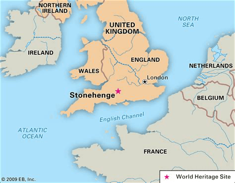
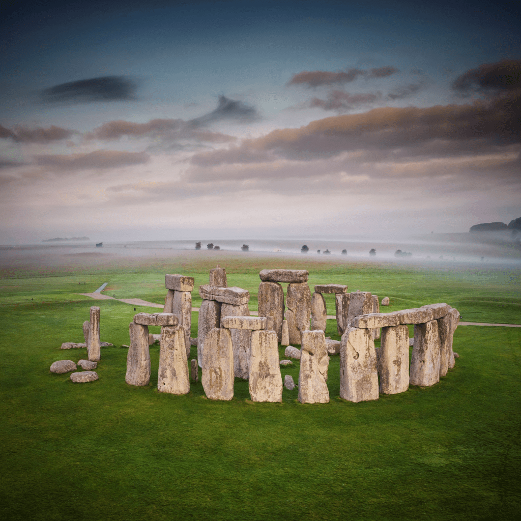
Prior to the increasing popularity of the history defining findings at Gobekli Tepe and aside from the enduring obsession with the perfection of the Pyramids at Giza, it is Stonehenge – located on Salisbury Plain in Wiltshire, England, eight miles north of the cathedral city of Salisbury – that is one of the most famous prehistoric landmarks in the world; perhaps capturing the fascination of people more than any other. Yet even so, this arcane monument remains one of the most mysterious.
The impressive feat of Stonehenge’s erection is incorrectly attributed to primitive man some five thousand years ago. While Stonehenge may not be as old as Gobekli Tepe or perhaps even the Great Pyramid (Article: The Pyramid Perplexity), its erection predates 3000 BCE by millennia. The size of the intricate set of stones belie a construction by the mysterious giants of the early epoch following the Younger Dryas event – refer articles: Nephilim & Elioud Giants I & II. The name of the monument may derive from the Saxon stan-hengen, which means ‘stone hanging’ or the more sinister ‘gallows’.
As Ancient Code note: ‘Not a single archaeologist has successfully explained how it was built. Interestingly, the how isn’t perhaps as mysterious as the why. Countless theories have tried explaining the real purpose of Stonehenge, yet experts have still failed to agree on one. Was Stonehenge an Astronomical observatory? Was it a religious temple? Was it [a] burial site? We still do not know.’ Of these options and if we follow the clues of the Cochno Stone, the Inga Stone and of Gobekli Tepe, then the first one is the most likely or foremost to consider – refer article: Monoliths of the Nephilim.
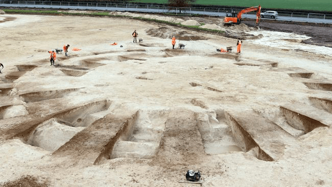
Graves have not been found at Stonehenge though a cemetery of Bronze Age burial mounds (above and below) has been unearthed less than ten miles distant. Live Science, June 15, 2023: ‘The cemetery includes more than 20 circular mounds, known as barrows, built between 2400 B.C. and 1500 B.C. on a chalk hillside near Harnham on the outskirts of Salisbury in southwest England. Other than the site’s proximity to Stonehenge, there’s no evidence that the cemetery was connected with the famous monument. One of the barrows was originally enclosed by an oval-shaped ditch that was replaced in prehistory with a nearly circular ditch. That suggests this barrow might have been built before the others, during the Neolithic period, which ended around 2400 B.C.; a mass grave near its center held the skeletal remains of adults and children…’
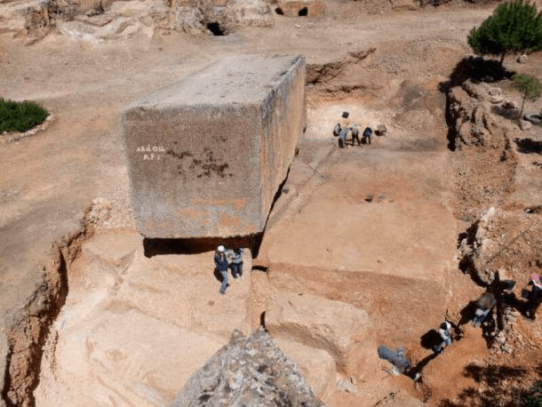
Whoever built Stonehenge, they were particular in the stones they chose. When restoration work was conducted in 1958, a rocky core was removed and kept as a souvenir. Robert Phillips was a representative of the drilling company assisting in the restoration of Stonehenge. He took the cylindrical core when it was drilled from one of Stonehenge’s pillars – coincidently, Stone 58.* Phillips later emigrated to the United States, taking the core with him. Due to Stonehenge’s protected status, it is not possible to extract samples from the stones any longer. Some sixty years later, the core was returned, providing ‘researchers the opportunity to perform unprecedented geochemical analyses of a Stonehenge pillar…’
The final stone is put in place during the restoration of Stonehenge on July 9, 1958,* with the giant lintel laid across the top of upright megaliths 57 and 58*
The results showed that the standing stones or sarsens – sandstone remnants of eroded Tertiary beds found in south-central England – were comprised of rock ‘containing sediments formed when the dinosaurs walked the Earth’.
According to an unconventional chronology, this would be far more recently than sixty-five million years ago. Similarly, other grains of rock in the pillar would date far later than the 1.6 billion years ascribed to them. English heritage: “Sarsens were erected in two concentric arrangements – an inner horseshoe and an outer circle – and the bluestones were set up between them in a double arc.”
Mindy Weisberger: ‘When the scientists peered through a microscope at thin slices of sarsen rock from Stone 58, they were surprised to discover that the stone was 99.7% quartz. A quartz “cement” held fine-to-medium quartz grains and formed “an interlocking mosaic of crystals”. That made the rock more durable, and it may have been why the builders chose that type of rock for their massive monument thousands of years ago.’ Author David Nash, a professor of physical geography at the University of Brighton in England: “These cements are incredibly strong. I’ve wondered if the builders of Stonehenge could tell something about the stone properties, and not only chose the closest, biggest boulders, but also the ones that were most likely to stand the test of time.”
Surely the condition of the Stonehenge stone slabs is a clue to their great antiquity; considerably older in construction than four to five thousand years ago. The error has been made in equating Stonehenge as just another stone circle. The construction of which is typically dated to beginning in 3000 BCE. What seems to have passed researchers attention is that Stonehenge is not just another stone circle and if it is the first, it set a precedent long before other cultures began following suit. The same scenario has occurred with the Pyramids of Giza setting a standard which granted was copied, but only millennia later and with workmanship incomparable to the originals.
English Heritage: ‘From the 1880s, various stones had been propped up with timber poles, but concern for the safety of visitors grew when an outer sarsen upright and its lintel fell in 1900. The then owner, Sir Edmund Antrobus, with the help of the Society of Antiquaries, organised the re-erection of the leaning tallest trilithon in 1901. This was the start of a sequence of campaigns to conserve and restore Stonehenge – the last stones were consolidated in 1964.’
It is interesting to note how English Heritage describe the site with such salient points as: ‘Stonehenge is the world’s best-known ancient stone circle… Built around the same time as the Great Pyramid in Egypt… the finished monument of massive and finely dressed sarsen stone was unlike anything ever seen across Europe. It is a powerful memorial… of… a time of transformations when landscape was being monumentalised in completely new ways…’ We will return to the significance of the circle formation.
This writer concurs with Stonehenge being unique and unlike anything else in Europe, because it was a monument from a far earlier millennia than is readily acknowledged. But perhaps still not within the earliest after the great flood. Mere mortals did not conceive or oversee the construction of either edifices. By English Heritage’s own admission, Stonehenge is utterly unique and a monument seemingly out of time and context in our world. A dating of only circa 2500 BCE is more incredulous than the accomplishments of the site itself.
‘The significance of Stonehenge itself can be summarised as follows:
Stonehenge is the most architecturally sophisticated and only surviving lintelled stone circle in the world.
The earliest stage of the monument is one of the largest cremations cemeteries known in Neolithic Britain.
The stones were brought from long distances – the [igneous] bluestones from the Preseli Hills, over 150 miles (250km) away [in South Wales], and the [Cenozoic silcrete] sarsens from West Woods, 15 miles (25km) north of Stonehenge on the edge of the Marlborough Downs.
The stones were dressed using sophisticated techniques and erected using precisely interlocking joints, unseen at any other prehistoric monument.’
An interlocking sarsen slab forming a circle
These points stand alone as vital clues to Stonehenge’s almost otherworldly design, but by putting them all together, is one not compelled to consider the possibly, that this monument was not formed by human hands alone, if at all? Even comparing the ancient decrepit Stonehenge with the modern complete Stonehenge II, there is no comparison. Stonehenge II ‘is a concrete sculpture in the Texas Hill Country, US, built in homage to the original… monument. Stonehenge II was conceived by Al Shepperd and built with the help of his friend and neighbor, Doug Hill. Originally located on FM 1340 west of Hunt, Texas, Stonehenge II now resides on the campus of the Hill Country Arts Foundation in Ingram, Texas.’
According to the signage at the site: ‘Stonehenge II is not a replica; it is about 2/3 the size of the original’ – so much for “everything being bigger in Texas” – ‘and it is not oriented to the sun, as is the original. Rather, it is Hill’s impression, in steel and concrete, of the nearly 5,000 year old circle of stones on the Salisbury Plain.’
Aside from Stonehenge II, there is a a full scale replica of Stonehenge in Maryhill, Washington. It was built by another Hill, this time Samuel Hill, who had visited the ancient monument during the war, and ‘was told it was used for human sacrifice by the Druids.’ Samuel Hill connected this story with the appalling loss of life during the Great War, building the replica as a reminder of those sacrifices and the “incredible folly” of war. It was dedicated in 1918 to Maryhill residents who had died in World War I.
In Sweden, there is as ancient megalithic structure shaped like a ship. It seems to have a similar geometry with Stonehenge, with one scientist saying it may have been used as an astronomical calendar.
There is a curious Stonehenge like structure located in Armenia, called Carahunge (or Karahunj). It is deemed a sophisticated astronomical observatory and oddly has beings with elongated heads and almond shaped eyes depicted on some of its rocks (above)… Other parts of the world also contain sites built on the principle of Stonehenge; such as Russia, the Sahara Desert, the Amazon, underneath Lake Michigan, Australia and even Stonehenge 2.0, about two kilometres from Stonehenge. Researchers discovered a massive stone arrangement of approximately ninety pieces of megalithic blocks of stone. The stones were discovered one metre beneath the surface and are around 4.5 metres in height.
English Heritage: ‘The earliest structures known in the immediate area are four or five pits, three of which appear to have held large pine ‘totem-pole like’ posts erected in the Mesolithic period [within 200m of Stonehenge’s future location], between 8500 and 7000 BC. It is not known how these posts relate to the later monument of Stonehenge.’ It is proposed that the true age of Stonehenge is within this time frame. Thus after Layer III of Gobekli Tepe, coinciding with Layer II and avoiding any conflict with the relationship of the posts in a non-different time.
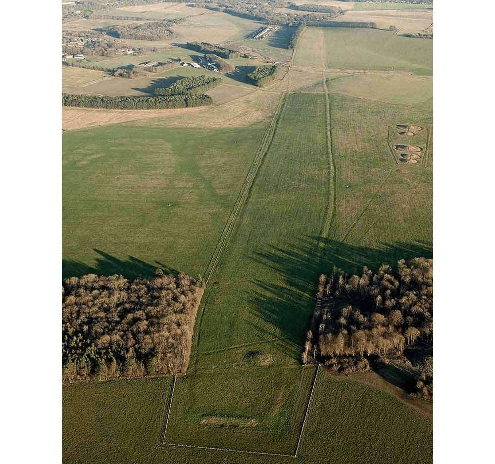
During this age, most of the rest of southern England was largely covered in woodland, so that the ‘chalk downland in the area of Stonehenge may have been an unusually open landscape.’ Explaining why it was chosen as the site for an early monument complex. The ‘complex included the causewayed enclosure at Robin Hood’s Ball, two cursus monuments or rectangular earthworks (the Greater, or Stonehenge, and Lesser Cursus), and several long barrows…’
The Greater, or Stonehenge, Cursus, a huge rectangular earthwork enclosure 1.7 miles long, seen from the air in 2000
The Normanton Down Barrows lie on the crest of a low ridge just to the south of Stonehenge. Excavation of these early Bronze Age barrows has produced several rich finds, including beads and other personal ornaments.
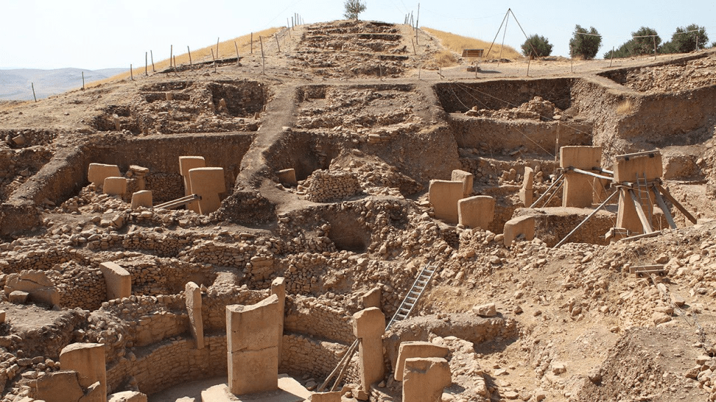
Stonehenge today is incomplete, with many of its original sarsens and bluestones having been broken up and taken away during Britain’s Roman and medieval periods. It was not until between 1874 to 1877 that Flinders Petrie made the first accurate plan of the stones and the first official archaeological excavation was conducted in 1901 by William Gowland.
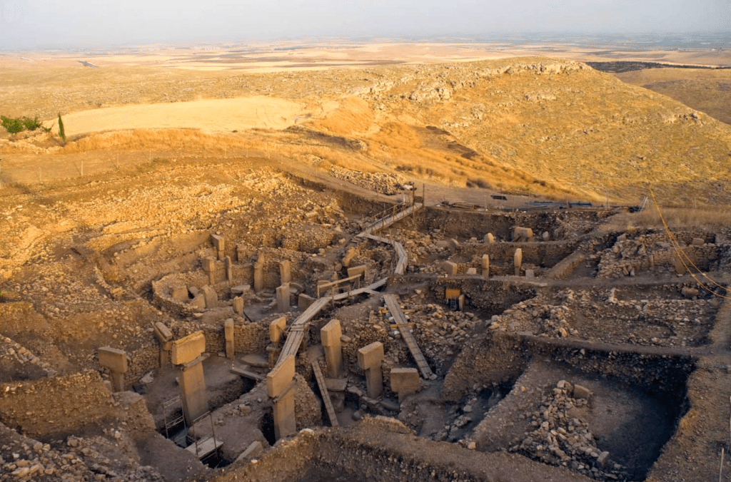
Stonehenge is thought to have been built in six stages. Britannica describe the enormous size of the individual monoliths:
‘They were then arranged inside the circle in a horseshoe-shaped setting of five tall trilithons (paired uprights with a lintel) – the central and largest of which is known as the giant trilithon – surrounded by 30 uprights linked by curved lintels to form a circle. The stones appear to have been laid out systematically in units and subunits of the long foot; the circumference of the sarsen circle is 300 long feet. The lintels, weighing some 7 tons each, are held on top of the uprights by mortise-and-tenon (dovetail) joints, and the ends of the curved lintels of the sarsen circle fit together with tongue-and-groove joints. All the joints were created using hammer stones, presumably in imitation of woodwork. Most of the sarsen uprights weigh about 25 tons and are about 18 feet (5.5 metres) high. The uprights of the giant trilithon, however, were 29 feet (9 metres) and 32 feet (10 metres) high, weighing more than 45 tons.
Only one of the giant trilithon’s uprights still stands, reaching a height above ground of about 23 feet (7 metres). Only six lintels (out of a total of 230) sit in place on the sarsen circle, with two more lying on the ground. Three of the five sarsen trilithon lintels are in place, with the other two on the ground. Four of the uprights from the sarsen circle are absent, and one is much shorter than the others. Although it is possible that the sarsen circle was never completed, the existence of a hole for an absent sarsen suggests that this stone and others were reused as construction materials for Roman buildings and medieval churches in the vicinity.’
‘Most of the surviving 45 original bluestones of Stonehenge are of spotted dolerite (also called diabase) from southwest Wales, specifically the Preseli Mountains. Other stones of rhyolite, rhyolitic tuff, volcanic ash, and dolerite are believed to be from the same region. A source for one of the rhyolites, however, was identified in 2011 as Pont Saeson, north of the Preselis. The Altar Stone (a toppled upright so called because it looked to the 17th-century architect Inigo Jones like an altar at the centre of the monument) and another two sandstone monoliths likely came from the Brecon Beacons, a cluster of mountains about 60 miles (100 km) east of the Preseli range. The bluestones weigh up to 4 tons each, and the taller ones are over 6 feet (2 metres) high. Most of them are unworked natural pillars.’
An important clue in the distinctiveness of Stonehenge is the fact that the ‘vast majority of Neolithic stone monuments throughout Western Europe were built less than 2km to 3km away from their stone quarries. So Stonehenge is a major exception to this rule, as its bluestones were dragged around 290km. This makes it unique for prehistoric Europe’, according to Mike Parker Pearson. He also makes the following claim: ‘I led the team of researchers that discovered that Stonehenge was most likely to have been originally built in Pembrokeshire, Wales, before it was taken apart and transported some 180 miles to Wiltshire, England. It may sound like an impossible task without modern technology, but it wouldn’t have been the first time prehistoric Europeans managed to move a monument.’ If such is the case, for the bluestones at least, this only reinforces the extraordinary capabilities of the designers and builders of Stonehenge.
Latest findings reveal that the Altar Stone was brought to the site from much further away than South Wales.
Mystery of Stonehenge deepens after ‘jaw-dropping’ discovery, David Keys, August 14, 2024:
‘Remarkable new scientific research at Stonehenge has revealed an extraordinary new mystery. Mineralogical tests on the massive six-tonne stone at the heart of the monument show that this central rock, known as the altar stone, was brought to Stonehenge from the far north of Scotland. The altar stone is arguably the most ritually important stone in Stonehenge, because it is the rock that marks the intersection of the prehistoric temple’s two most important celestial alignments – the winter solstice sunrise to summer solstice sunset alignment, and the summer solstice sunrise to winter solstice sunset alignment.
… moving a rock from northern mainland Scotland or Orkney would have involved a journey of well over 500 miles. The discovery has huge implications, and is likely to transform archaeologists’ perceptions around key aspects of life in prehistoric Britain. Dragging a six-tonne rock across mountains, hills, valleys and at least 30 rivers for well over 500 miles (in practice probably at least 700 miles) would have taken several years to accomplish – so it seems relatively unlikely that the rock was brought over land from northern Scotland to Wiltshire. It’s far more probable that it was brought by sea, a journey that would have taken just a few months. What’s more, the stone would almost certainly have been accompanied on its journey by a large team of mariners, priests and others – so it’s conceivable that it proceeded south as part of a substantial flotilla.
The North Sea is often far from calm, so the craft would have needed to deal with some relatively choppy waters, and of course the flotilla’s navigators would have needed to have prior knowledge of the coastline of at least eastern Britain. It’s likely, therefore, that the flotilla proceeded south, hugging Britain’s east coast for some 700 miles, and then turned west into the Thames estuary, along the Thames and part of the Kennet until Newbury or possibly Hungerford, where the rock would have been unloaded and then dragged (on a sledge or on rollers) for at least 30 miles to its final destination, Stonehenge.
But why did the… builders of Stonehenge want a northern Scottish (or Orkney) rock as the symbolic centre of their spectacular southern British stone temple? At present there is no way of knowing for certain the answer to that question. However, it is possible that the concept of stone circles was first developed in Orkney – and that somehow the builders of Stonehenge were aware of that. It is therefore conceivable that they wanted to ensure that the central feature of their new monument came from Orkney. Indeed, it is possible that the six-tonne rock had been chosen specifically for its religious significance – and that it had formed part of a major stone circle in Orkney.
No doubt, archaeologists will be investigating that possibility – not least because the great rock brought well over 500 miles to Stonehenge is roughly the same size and shape as some of those used in the construction of stone circles in Orkney. So perhaps the builders of Stonehenge were deliberately paying homage to what they might have perceived to be their great temple’s ideological/theological ancestor. It also suggests that the builders of Stonehenge viewed their great monument as a composite temple made up of components from across a much wider geographical and ideological landscape, symbolically and perhaps even spiritually incorporating several different parts of Britain (certainly including Wales and mainland Scotland or Orkney [with England]).
… it was a British geologist at Curtin University who did the crucial research, pinpointing a northern Scottish/Orkney origin for Stonehenge’s central stone. They identified the stone’s mineralogical fingerprint (and crucially, the geological ages of that fingerprint – ranging from around 3 billion to around 460 million years), which showed that the closest match by far was the extreme north of Scotland (including Orkney). “It’s been a two-year voyage of discovery for me and my colleagues. We collated more than 500 ages for the minerals within the altar stone, and it was those ages which, when correlated, gave us the crucial chronological fingerprint which revealed the northern Scottish origin of the rock,” said Anthony Clarke, the British geologist who carried out the crucial research at Curtin.’
The total number of sarsen stones that were needed for the completed site totalled eighty-two; comprising ten trilithon uprights; five trilithon lintels; thirty circle uprights; thirty circle lintels; four Station Stones; and three Slaughter Stones. Approximately eighty bluestones were required, of which sixty uprights formed the bluestone circle. Six bluestones were found to have distinctive shapes, with grooves and holes cut into them. Today there are 83 stones remaining at the Stonehenge site and 43 bluestones.
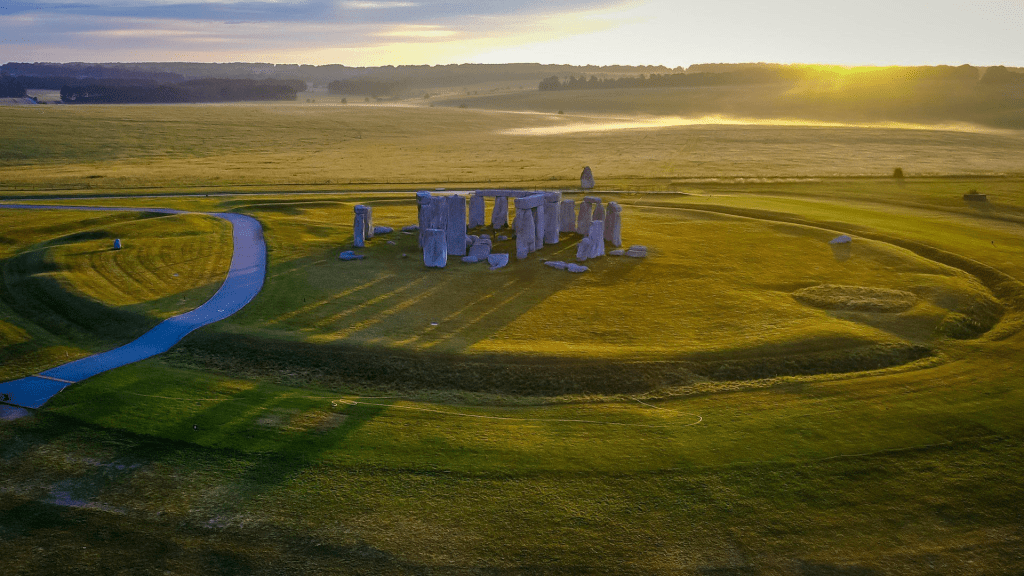
Stonehenge as the world’s most famous stone circle, is visited by more than a million people each year. ‘It stands as an icon for all that is mysterious and awe-inspiring about humanity’s prehistoric past.’ For over a century, people have gathered at the monument to celebrate the longest day of the year and watch the sun rise over the stone ruins on the summer solstice in June (above). The gathering was banned in 1985 after violent clashes with police, though was resumed in 2000 and draws more than 30,000 people.
People from all over the world attend, including ‘New Agers, neo-pagans, Wiccans and sun-watchers.’ Modern Druidic societies claim Stonehenge as their own temple, even though the identification of Stonehenge with the original Druid Order is unsubstantiated. The first notable society, the Ancient Order of Druids was formed in 1781. In recent years the number of Druidic and Neo-Pagan groups ‘has risen in tandem with the decline in conventional religious belief.’
We have a more accurate idea on when Stonehenge was begun and an evolving understanding on who was responsible for Stonehenge as well as the other megalithic sites around the globe – Article: Monoliths of the Nephilim. This leaves the most enigmatic question: Why was Stonehenge built?
English Heritage: ‘Stonehenge has perhaps been the focus of more theories about its origin and purpose than any other prehistoric monument. Today, the interpretation which is most generally accepted is that of a prehistoric temple aligned with the movements of the sun. It is the most striking example… [of] places to honour… ancestors and mark important moments in the calendar. At the centre of this belief system was the sun, with the solstice alignments enshrined within the fabric of the monument.’
This is a superficial answer at best, skimming only the surface. For an ancient race of mixed human and angelic genealogy were constructing monuments of not just great size and scale, but of intricate and complex design. It behooves us to question our interpretation of the purpose for not just Stonehenge, but every arcane site. A starting point in answering the enigma of Stonehenge is an article by Tia Ghose, where she lists seven reasons why Stonehenge may have been built.
There is some overlap with a few of them and applying Occam’s razor may just assist in eliminating the incorrect propositions. The area surrounding Stonehenge may have become a sacred hunting ground [1]. Archaeological evidence points to an auroch migration route thousands of years before the first stones were raised.
Ghose adds: ‘A site just a mile away from the Wiltshire… megaliths contains evidence of human occupation… including thousands of auroch bones, flint tools and evidence of burning.’ Tellingly, ‘the Stonehenge site itself bears evidence of construction as far back as 8,500 to 10,000 years ago… This archaeological evidence hints that the site was originally an ancient hunting and feasting site, and perhaps the megaliths were raised to memorialize the meaty bounty.’ While ‘hunting and feasting’ likely took place at Stonehenge, the building of a monument to immortalise that fact seems unlikely.
A similar though just as unlikely reason for Stonehenge put forward, is that its ‘construction may have been about more than primeval barbecue cookouts’ and that they ‘were erected to celebrate peace and unity.’ According to Mike Parker Pearson of University College London Institute of Archaeology:
“Stonehenge itself was a massive undertaking, requiring the labor of thousands to move stones from as far away as west Wales, shaping them and erecting them. Just the work itself, requiring everything literally to pull together, would have been an act of unification.” There is no doubting the extent of the collaborative effort required in constructing Stonehenge, but its purpose as a unity monument [2] or a symbol of a glorified team building exercise, remains unconvincing.
A third reason proposed for Stonehenge is that it was a healing site [3]. This is based on archaeologists Geoffrey Wainwright and Timothy Darvill, who in 2008 reported that a significant number of skeletons recovered from Stonehenge bore signs of illness and injury. Credence to this theory stems from finding that many of the bluestones had chip marks, highlighting people had taken chips away with them, perhaps as ‘talismans for protective or healing purposes.’ Though, people may have simply taken them as souvenirs in superstition of an auspicious site.
Stonehenge may have been a place for burial, but not just for anyone but an elite cemetery [4]. Remains which were deemed unimportant and reburied were re-exhumed by British researchers, comprising more than fifty thousand cremated bone fragments and representing sixty-three separate individuals including men, women and children from Stonehenge. Archaeologists found a mace head and a bowl possibly used to burn incense; suggesting the buried people in the graves were possibly religious or political elite. Though people were buried in the vicinity of Stonehenge, it does not stand as a viable reason for its construction.
An intriguing aspect of Stonehenge, is that of its acoustic qualities producing an illusory soundscape [5]. The theory proposed by Steven Waller, an archaeoacoustics researcher is that Stonehenge’s circular construction was created to mimic a sound illusion. For instance, if two pipers played bagpipes in a field, a listener would notice a strange effect, for in certain areas, the sound waves from the dual pipes would cancel each other out, creating quiet spots. In this case, it is the stone slabs which create a similar effect, on any sounds originating from the centre of the circle, instead of competing sound waves, blocking noise. Thus the megaliths might have been designed to augment the area’s natural sound cancellation; using the boulders to selectively block sound.
According to Waller, prehistoric circles are traditionally known as “piper stones.” Legend associates Stonehenge with pipers and tells of magic pipers who led maidens to the field and then turned them into stones. A study confirmed that the circle would have caused cavernous sound reverberations similar to those in a modern day cathedral or concert hall. Not everyone who has studied the acoustics of Stonehenge, subscribes to the belief there is any evidence ancient people designed the circle of stones with sound as its primary function.
A similar theory, after researchers had the ‘rare chance to thwack the giant megaliths’ postulates that the dolerites and sarsens at Stonehenge produce ‘unique, subtly different sounds similar to hollow wooden or metallic giant bells’ [6]. Therefore, as the sounds would have carried over a long distance, the monument may have once been an ancient ‘communication system’ or a ‘Stone Age church bell.’ The use of rocks to create music is not new. Numerous ‘cultures have employed lithophones – essentially giant Flintstones-like xylophones that produce unique sounds.’ As with the illusory soundscape, it seems likely that this musical quality is either an interesting byproduct of its construction or a secondary function of Stonehenge at best.
The final purpose proposed for Stonehenge is the one which not only makes sense, but also follows the pattern of the Cochno Stone, the Inga Stone and Gobekli Tepe. Until a better explanation is presented, the use of Stonehenge as anastronomical calendarand celestial observatory [7] is the most plausible and practical. It does not necessarily follow that the ancients observed the winter solstice in December, yet an avenue near Stonehenge – connecting the monument with the nearby River Aven – is aligned with the mid-winter solstice sunset and archaeological evidence ‘suggests that pigs were slaughtered during December and January – possibly for a mid-winter feast.’ Though this might be a later rite and not an early original ritual.
As the site also faces the sunrise during the mid-summer solstice in June, a connection with the Sun’s movements was obviously intended and planned by its designers and builders. Stonehenge’s alignment with the Sun and probable use for observing the Moon as well, may mean it had a role in working out the planting and farming seasons. When looking toward the sunrise, the entrance in the northeast points over a big pillar leaning at an angle, called the Heel Stone. Looking the other way, it points to the midwinter sunset.
In 1963, American astronomer Gerald Hawkins proposed that Stonehenge was constructed as a ‘computer’ to predict lunar and solar eclipses. Other scientists have attributed astronomical capabilities to the monument. As with Gobekli Tepe and other sites, most of these speculations have been intriguingly, rejected by experts.
In Gods of the New Millennium, 1997, Alan F Alford addresses the astronomical nature of Stonehenge:
‘On Salisbury Plain in Wiltshire, England, 80 miles south-west of London, stands [a] calendrical computing machine… made of stone… the most famous prehistoric monument in the whole of Europe… Centuries of study have been unable to solve the mystery of who built Stonehenge and why, but modern science has been able to lift the veil on many of its secrets. It is now generally accepted that, from its beginning, Stonehenge was an astronomical observatory, aligned exactly to the midsummer solstice.
Following extensive surveys of the site, archaeologists believe that the layout of the monument has been changed several times during its history. The earliest phase was a circular area, known as a “henge” more than 300 feet in diameter, with a ditch and a raised bank around its circumference. One of the most exciting features of Stonehenge occurred during this earliest phase. Four Station Stones, positioned on the edge of the circle so as to form a rectangle, marked out a sophisticated set of alignments to a 19-year cycle of the Moon! Possibly contemporary with the first phase is a series of 56 mysterious holes, which were made in a circle just inside the bank.
One of the most intriguing mysteries of Stonehenge is why these holes, known as Aubrey Holes after their seventeenth century discoverer John Aubrey, were filled in immediately after they were dug. The initial henge was left basically unaltered for 300 years, but then underwent a series of dramatic changes… 80 bluestones, each weighing 4 tons, were transported across a distance of 250 miles from Wales, and placed in a double circle of “Q and R holes” inside the henge. The introduction of these stones literally made the site a “stone henge” for the first time.
However, it is not clear whether the bluestone circles were ever completed, because… the builders adopted a radical new design. The bluestones were removed, and substituted by huge sandstone boulders, known as “sarsen” stones. These stones, weighing 40 to 50 tons each, were somehow transported over a river and steep gradients, from the Marlborough Downs, 12 miles to the north. They were then erected to form the Sarsen Circle, comprising 30 uprights, joined across the top by lintels. These lintels were carefully cut in a curved form to create a continuous ring when assembled, and stability was ensured by linking them to the uprights using the mortise and tendon joint which is familiar to carpenters.
When the Sarsen Circle was completed, the builders turned their attention to the construction of a giant causeway, known as the Avenue, which extended from the circle’s entrance as far as the River Avon two miles away. No-one has ever explained why such a long causeway was required. A 35-ton stone, known as the Heel Stone, was probably erected at this time. This stone, standing 16 feet high, and buried 4 feet into the ground, was erected 100 feet away from the circle, opposite its entrance, in order to create an axis which pointed to sunrise at the time of the summer solstice.
There then followed a 400 year hiatus, at the end of which, for some unknown reason, the builders decided to bring even bigger stones onto the site. Five pairs of enormous sarsen stones, joined across the top by lintels, were erected inside the Sarsen Circle, in the shape of a horseshoe. These 13-feet high trilithons, for which the site is most famous… remain in excellent condition today. It is believed that, around this time, the site was given a new axis, to realign it with the summer solstice. This involved the erection of a two-stone sight-line just outside the henge, and the shifting of the Heel Stone slightly to the east so as not to interfere with the new sight-line.
A short time later… the bluestones were reintroduced to Stonehenge. One, the 16-feet high Altar Stone, was set upright in the centre of the complex, directly on its axis with the midsummer solstice. Two concentric circles of bluestones were then erected between the Sarsen Circle and the trilithons. Finally… 19 bluestones were set up to form a horseshoe inside the trilithons. After this flurry of activity, all went quiet for around 500 years, followed by a minor addition of the so-called “Y… holes”. Then the site was abandoned.
Stonehenge is an unusual site in the sense that it is the astronomers rather than the archaeologists who have led the research from the beginning. As early as 1740, William Stukeley discovered that the central axis of the site from the Altar Stone through the Heel Stone and the Avenue pointed to the position of sunrise at the summer solstice. This alignment was confirmed unequivocally by Sir Norman Lockyer in 1901. The debate then shifted to other possible astronomical alignments, particularly since the site had many other features which could not be accounted for. In 1963, it was suggested that the site could have been used for observing and predicting the equinoxes as well as the solstices.
Then in 1964, Cecil Newham stunned the academic world with his proposal that Stonehenge was also used as a lunar observatory, based on the rectangle formed by the four Station Stones. His findings were confirmed by Professor Gerald Hawkins in various studies between 1963-65 using computer analysis, Hawkins proved that Stonehenge was not only aligned to certain key points in the cycle of the Moon, but also designed to predict lunar eclipses. These conclusions were simply too much for the scientific establishment, because lunar cycles are far more complex than solar cycles, and it was unthinkable that Neolithic people could have had such an advanced knowledge of astronomy’ – Article: The Calendar Conspiracy.
This would be an entirely valid argument and conclusion if Stonehenge had been designed by ‘Neolithic’ peoples but, if built earlier in the Neolithic era – yet after the construction of Gobekli Tepe (and perhaps prior to the Great Pyramid) – this would fit the time frame, the mind set and capabilities of the formidable race of Nephilim and Elioud giants who while ranging over the whole Earth, were constructing megalithic structures following the Flood cataclysm. Giants dwelling in the British Isles is well documented – refer Chapter XXXI Reuben, Simeon, Levi & Gad – the Celtic Tribes.
Alford: ‘Alexander Them published the most comprehensive survey of the site in the mid 1960s, which confirmed both lunar and solar functions for Stonehenge from its very beginning; it was clear, he said, that the site was in a unique location, for nowhere else would the lines formed by the rectangle of Station Stones point exactly to the eight key points of lunar observation. If the site had been positioned only a few miles further north or south, this geometrical relationship would not have worked.
When Sir Fred Hoyle concurred with these findings in the late 1960s, the lunar theory suddenly became respectable. Hoyle declared Stonehenge to be not just an observatory but also a predictor of astronomical events; he felt that the builders of Stonehenge might have come to the British Isles from the outside, purposely looking for this rectangular alignment… just as the modern astronomer often searches far from home for places to build his telescopes.’
‘The indisputable conclusion is that whoever designed Stonehenge must have known in advance the precise length of the solar year and the cycle of the Moon. Even more impressively, these ancient astronomers had the skill to identify a unique location for the measurement of the Moon’s 19-year cycle! Many reference books today are still, understandably, reluctant to cite the full evidence on Stonehenge, for conventional history simply cannot explain the advanced technology of the people who came here [thousands of] years ago.’
In endeavouring to understand Stonehenge, it is worth looking at a completely different topic, yet at the same time oddly related. And that subject is crop circles. Notice the word circle. Two of the most famous and important megalithic monuments in the world, Stonehenge and Gobekli Tepe are arranged in circular shapes – refer Gobekli Tepe, article: Monoliths of the Nephilim. This cannot be mere happenstance. Our very home, which teems with life is described as a sphere in the scriptures.
Isaiah 40:22, describes the relationship of the Creator with the blue-green orb we call Earth. “… the one who sits above the circle of the earth…” – Evangelical Heritage Version. The Expanded Version says: “God sits on his throne above the circle of the earth…” While The Message Bible describes it simply and more graphically as: “God sits high above the round ball of earth…”
A link exists between the roundness of the Earth and the cycle of life. The essence of life, an ovum, is a circular sphere. Call it the ‘circle of life’ if you will. Associated with this are astronomical observations and calculations of planetary bodies within the cosmos, whether it be the Sun, the Earth or the Moon. All are integral to life on this planet. Symbols, whether used as as good or for evil, such as the swastika; a cross; or the Ashoka Chakra; each represent a spinning motion which turns the shape into a circle and symbolises life, birth, regeneration and infinity. And life equals energy.
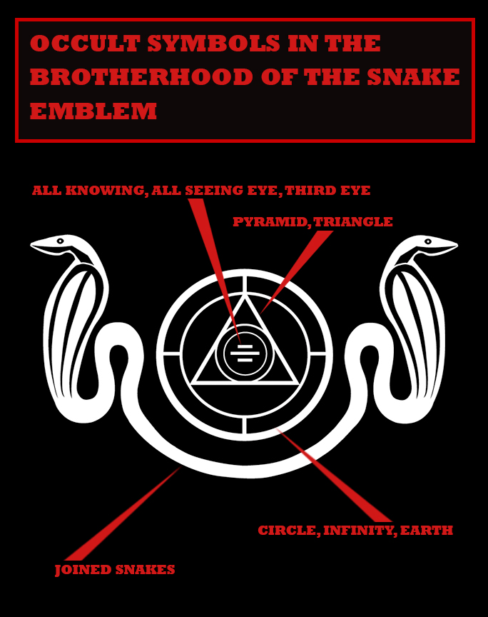
The Ouroboros snake is an image of a serpent (or dragon) eating its own tail. This symbolises its ‘continual devouring of itself and being reborn from itself’ as well, as the ‘unity of all things, material and spiritual, which never disappear but perpetually change form in an eternal cycle of destruction and re-creation.’ It is the ‘oldest allegorical symbol in alchemy’ and represents the ‘concept of eternity and endless return like the sun.’
The Ouroboros snake represents the Serpent in the Garden of Eden and so in turn is the founder and inspiration for the Brotherhood of the Snake, which interestingly ties in with the Atlantis city-state designed as a series of concentric circles – Chapter XXII Alpha & Omega; and article: Monoliths of the Nephilim.
The Richat Structure located in Mauritania, North Africa, has led some to believe that the naturally formed structure is in fact the residue of Atlantis – Article: Antartica: Secrets of the Lost Continent of Atlantis.
We see this pattern of concentric circles repeated in Gobekli Tepe, Stonehenge and yes, in various crop circles. A crop circle by definition is ‘an area of standing crops [such as wheat, barley or canola] which has been flattened in the form of a circle or more complex pattern. No general cause of crop circles has been identified although various natural and unorthodox explanations have been put forward; many are known to have been hoaxes.’
This topic is controversial and many people are dubiously sceptical. As with much unexplained phenomena, some causes are certainly entirely human inspired, or not so inspired as the case may be. Yet there is always a percentage of instances which remain in the realm of the inexplicable.
Perhaps some do not wish to contemplate what it might mean if extraterrestrial or invisible entities are using laser type technology to image intricate patterns on crops, presumably in the small hours of the night. But, what if the genuine crop circles are of just such an origin. What then?
As more crop circles are reported in the South of England than anywhere else in the world; with most crop circles created in Wiltshire – where Stonehenge is (coincidently) located – than in any other county; and as the original Stonehenge from above looked like, well… a crop circle, it is worth investigating the link.
Live Science, Stephanie Pappas: ‘The first report of a crop-related mystery now linked to crop circles was a woodcut chapbook, or small book containing ballads and poems and tracts, called “The Mowing Devil,” dating back to 1678. According to Oxford Reference, this chapbook tells the tale of a cheap farmer who refused to pay a laborer to cut his oats. Overnight, the devil did the job instead, “cutting them in round circles.”
Right from the reported beginning of this phenomena, a supernatural explanation is cited. It is not the intention to delve into whether occupants of UFOs are responsible or not for the formation of crop circles. This writer has addressed the subject of who are inside UFOs in other articles and may concentrate on UFOs specifically in a future article – refer article: Potentates & Principalities: What they want… Who they are; and Chapter XXII Alpha & Omega. What is the primary concern, is what the non-human crop circle formations signify and what if any correlation they may have with Stonehenge.
Britannica: ‘Beginning in the late 1970s, simple crop circles began to appear regularly in the fields of Wiltshire, Oxfordshire, Somerset, and Gloucestershire in southern England [but it was in the late 1980s that the phenomenon exploded – coinciding with the beginning of the Age of Aquarius (1990)]. They were made at night, and over the years they became more complex, growing into large patterns of geometric forms hundreds of feet across.’
The crop circles are invariably centred around highly charged electromagnetic ley lines – mystical seams of spiritual energy that intersect at sacred sites like Avebury and Stonehenge – refer Ley Lines, article: The Pyramid Perplexity.
‘Some people who studied crop circles were convinced that their intricacy and the fact that the plants seemed to be bent but not broken precluded a human creator, which meant that they were being produced either by some unknown natural phenomenon or by extraterrestrials.’ The elaborate designs surely suggest an advanced civilisation.
Dylan Thomas is a co-founder of the Atlas Obscura: A Compendium of the World’s Wonders, Curiosities, and Esoterica. In an article entitled, “Crop Circles” Reveal an Ancient Burial Site a Thousand Years Older Than Stonehenge, in 2009 it says:
‘… there is… another set of “crop circles,” [above] made… by the gravesites of prehistoric man… National Geographic “… older than nearby Stonehenge, the site includes the remains of wooden temples and two massive… tombs that are among “Britain’s first architecture,” according to archaeologist Helen Wickstead, leader of the Damerham Archaeology Project. Discovered during a routine aerial survey by English Heritage, the U.K. government’s historic-preservation agency, the “crop circles” are the results of buried archaeological structures interfering with plant growth”.’ While these images below the surface of the landscape are not crop circles per se, it is of note that they are circular.
England’s Crop Circle Controversy, August 21, 2021, Daniel Stables:
‘Although these mysterious formations have appeared worldwide, south-west England is the unlikely world capital of crop circles, baffling locals and farmers alike.’
One can only wonder regarding why the pre-occupation with the southwest of England. It is worth reminding the constant reader of the significance of this region in England – particularly Glastonbury in the county of Somerset – as once being the home and at that time, of a little known son of an unknown Judean carpenter whose name was Jesus (Yeshua) – refer Appendix VIII: When the Creator came to dwell with His Creation.
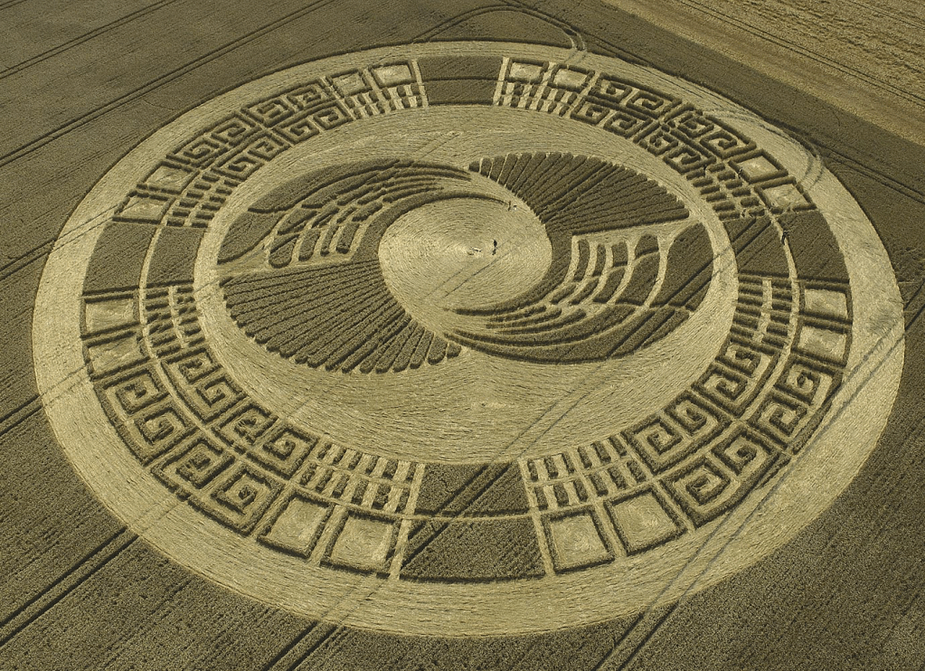
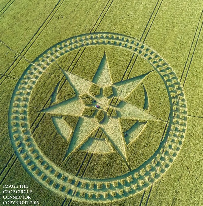
Stables: ‘The intricacy and size of the formations, coupled with the fact that they would appear overnight, seemingly out of nowhere, baffled locals and farmers alike. In 1996, a crop circle appeared opposite Stonehenge depicting a mathematical fractal called a Julia set – a similar formation that emerged on Milk Hill in 2001 was one of the largest ever, stretching 900ft’, comprising a script of Hebrew-like letters.
Benjamin Radford: ‘On Sunday, July 7, 1996, what has been called “one of the most complex and spectacular crop circle designs ever seen” appeared in England. It is unique in crop circle history for several reasons, including the fact that it appeared not far from the mysterious and world-famous Stonehenge monument in the English countryside – and that it allegedly appeared during daylight in less than an hour. The circle became one of the most famous and important crop circles in history and has been claimed to be one of the best cases for crop circles.
Indeed… [noted] researcher Colin Andrews expressed the sentiments of many when he said at several public conferences … “If these Julia Sets can be proven to be made by humans, then we can all pack our bags and go home.“
‘The circumstances surrounding its appearance are, at first glance, straightforward and impressive enough: A pilot flew over the field opposite Stonehenge late one afternoon and saw a normal, undisturbed field below; on his return flight less than an hour later, the pilot was stunned to see the spectacular 600-foot fractal crop circle below in that very same field. Soon word of the circle’s discovery spread, and it made international news. Yet there exists no photographs or video of it being made; it seemingly spontaneously appeared in minutes. The validity of this crop circle rests almost entirely on eyewitness testimony and a timeline of events suggesting that the crop circle must have appeared in between the two flights, approximately twenty to forty-five minutes apart.’
A Julia set is a ‘set of complex numbers which do not converge to any limit when a given mapping is repeatedly applied to them. In some cases the result is a connected fractal set.’ It is named after the French mathematician Gaston Julia who investigated their properties in 1915 and culminated in his famous paper in 1918: Mémoire sur l’itération des fonctions rationnelles. It is also known as the Fibonacci sequence, the Golden Ratio or the Golden Spiral.
Bitesize: ‘These mysterious numbers and shapes are all connected to each other. If you look closely, they can be found in the most unexpected of places, creating beautiful and pleasing patterns [such as in art, architecture and biology]. Put simply, the Fibonacci sequence is a series of numbers which begins with 1 and 1.
From there, you add the previous two numbers in the sequence together, to get the next number. This is a type of recursive sequence. So 1+1=2, 1+2=3, 2+3=5, and so on. This gives you a sequence that looks like 1, 1, 2, 3, 5, 8, 13, 21, 34, 55 etc. But what makes this sequence so special and interesting?
… Fibonacci numbers can be found in the natural world all around us. Most flowers, for example, will have a number of petals which correspond with the Fibonacci sequence. Irises have three petals whereas wild roses and buttercups have five petals. That is of course, until a petal falls off. No wonder rare four leaf clovers are seen as lucky! If you cut into a piece of fruit, you’re likely to find a Fibonacci number there as well, in how the sections of seeds are arranged. Bananas have three sections whilst apples have five.
The Fibonacci sequence even plays a role in the subtle spirals you can see in the seed head of a sunflower. This is because of something known as the Golden Ratio, the Golden Section or the Greek letter Phi. If you take a number in the sequence above 5, and divided it by the previous number, you will get an answer very close to 1.618. The larger the numbers, the closer you get to 1.618. The Golden Ratio is an irrational number, and so cannot be written as a fraction.
Take the sunflower. To be as efficient as possible, its seeds need to be closely packed together without overlapping. Now, if it simply grew seeds in a straight line in one direction, that would leave loads of empty space on the flower head. The best way of minimising wasted space is for the seeds to grow in spirals, with each seed growing at a slight angle away from the previous one. If the degree of turn was a fraction, like 1/4, that doesn’t help matters much because after four turns the seed pattern would be right back at the start again. There would be four lines of seeds, but that’s not much better than one when trying to cover a circular area. The perfect degree of turn needs to be an irrational number, which can’t be easily approximated by a fraction, and the answer is the Golden Ratio.
Another way of thinking about the Golden Ratio is as a spiral. This spiral gets wider by a factor of 1.618 every time it makes a quarter turn (90°). Drawing a perfect Golden Spiral is pretty tricky to do by hand, but just like with the Golden Ratio, you can get a close approximation with the Fibonacci Spiral. This is created by drawing an arc through a series of squares which correspond to the Fibonacci numbers, so 1², 1², 2², 3² etc.’
‘You might have seen these spirals superimposed over famous pieces of artwork, as experts try and explain why we find them so aesthetically pleasing. Often, the spiral draws in our eye so that the focus of the artwork is found in the centre of the spiral. Examples can be found in the works of Leonardo da Vinci and Salvador Dali. Fibonacci didn’t actually discover the sequence himself. Born Leonardo Bonacci in 12th-Century Pisa, Italy, the mathematician travelled extensively around North Africa. There, he learnt how the Hindu-Arabic numerals of 0-9 could be used to complete calculations more easily than the Roman numerals still in use across much of Europe.
Fibonacci explained his findings in a book called Liber Abaci, published in 1202, which had a section devoted to the intriguing sequence which would be named after him hundreds of years later. Indian poets and musicians had already been aware of the Fibonacci sequence for centuries though, having spotted its implications for rhythm and different combinations of long and short beats.
Mozart made use of the Golden Ratio when writing a number of his piano sonatas. A sonata can be divided into two separate sections, known as the exposition (where the theme is introduced) and the development and recapitulation (where the theme is developed and repeated). In Mozart’s sonatas, the number of bars of music in the latter section divided by the former is approximately 1.618, the Golden Ratio.
There’s even a style of poetry inspired by the Fibonacci sequence, known as Fib Poetry. Every line of the poem must contain the exact number of syllables that correspond with the Fibonacci sequence. So a six line poem would have syllable line counts of 1, 1, 2, 3, 5 and 8.’
Whomever hurriedly stencilled the Fibonacci spiral adjacent to Stonehenge was sharing their understanding of a simple sequence, yet complex structure replicated throughout nature as well as in human’s creative endeavours. Were they showing they were our equals in the least, or more likely, our superiors? Why did they break protocol and draw it in broad daylight instead of under cover of night? Is it a message of some kind or merely a simple statement of fact? Have we only scratched the surface? Is there more to the Fibonacci sequence than meets the eye? Would a deeper understanding assist scientific advancement?
Daniel Stables: ‘A 2008 formation near the Iron Age hill fort of Barbury Castle required decoding by an astrophysicist, who concluded that it was a geometric representation of the first 10 digits of pi.
The phenomenon peaked in the 1990s and early 2000s, but continues today; an average of 30 crop circles appear each year in the UK, around 80% of them in Wiltshire.’ There have been 380 crop circles recorded in the county since 2005. ‘Formations reported in 2021 have included a hexagonal pattern overlaid with spirals in Avebury, and a pattern of concentric “bubbles” in Tidworth Down. Crop circle season usually begins at the end of May, with the first ripening of the barley, and ends by September when the harvesting of the crops cuts away the circle canvasses.
Reports of cameras suddenly breaking and car engines turning themselves on in the vicinity of crop circles are common. “I’ve seen several orbs of light,” said [Monique] Klinkenbergh [crop circle researcher]. “I once saw a UFO; not a classic flying saucer, but a strange object hanging stationary in the air and eventually flying away with enormous speed. According to locals, these lights and strange objects have been witnessed for centuries.”
Regarding hoaxers, “Some of the formations are so intricate and so big that I can’t see two people doing them,” said Tim Carson, a farmer in the Wiltshire village of Alton Barnes. “Some of them are 300m long and they go over the brow of a hill. How would you know the other person’s doing the same thing you are?” Carson is more qualified than most to comment, having seen hundreds of crop circles appear in his fields – ravaging thousands of pounds worth of crops in the process. It all began in 1990, when a famous formation known as the Eastfield Pictogram appeared overnight in one of Carson’s fields. It caught the attention of the world’s press, and a photograph of the crop circle [below] was even used as cover art by Led Zeppelin.’
Some hoaxers have claimed to be behind the crop circles, but the intricacy and size of the formations continues to baffle many people
“Within days we had thousands of people turning up,” Carson said. “We charged people a pound a time, had keyrings and T-shirts made. It became probably our most profitable quarter of an acre ever. Some of the circles are mysterious, without doubt,” he said. “Sometimes the crops appear woven, lying one way and another on top of each other. That would take hours and hours to do by hand.” In a different article, Monique Klinkenbergh is quoted as saying she thought the reason for Wiltshire’s record number of crop circles was linked to the numerous ancient sites in the county. “The county is so famous for those sites of heritage, and I believe the crop circles are attracted to those places.”
Some of at the more notable examples of crop circles near Stonehenge include the following.
Silbury Hill, Wiltshire, 2005
Woodborough Hill, Wiltshire, 2009
Near Amesbury, Wiltshire, 2013
Near Amesbury, Wiltshire, 2016
Coneybury Hill, Wiltshire, 2018
Observing the series of crop circles, it can’t be helped being in awe of their intricacy and aesthetic appeal. Their circular commonality could be representative of planets, stars or constellations perhaps?
Another giant crop circle appeared next to Stonehenge in 2018 just before the Summer Solstice. Matthew Williams ‘captured the stunning formation, near Amesbury, Wiltshire, about a mile next to the world heritage site. The 180 ft formation [below] contains five spokes and five off-set petal-like shapes, as well as Aztec-style patterns.’ The 47-year-old crop circle expert said: “I think it’s quite timely that it appeared in the area right before the Solstice. To me, it kind of looks like a combination lock – but the flowers obviously represent the passage of time and the changing of the seasons. It’s very unusual to see offset shapes in these geometric designs, so that’s why I think this is a special formation.”
All these crop formations comprise and include circles; they are all located near Stonehenge and from a birds eye view, could easily have their inspiration from the ancient monument. Could the answer to the purpose of crop circles, be to point mankind to a practical process? Similarly, Stonehenge may have an overriding practical function rather than merely a ceremonial one. Recall, the shape of a circle symbolises life and life equals energy. Interestingly, an Italian inventor believes crop circles are models for generating free energy.
Ancient Code: ‘In 1991… “Crop Circles: Harbingers of World Change” by Alick Bartholomew… explored the idea that some crop circles could be messages from non-human intelligence… beyond this physical world. In the book, an English historian and psychic, Isabelle Kingston, suggested that crop circles… reveal a molecular structure or blueprint for a new form of energy that would one day be unraveled by scientists. One Italian inventor, Umberto Baudo, believes crop circles may be meant to impart secrets of new technology and free energy to humanity.
In 2008, Umberto Baudo decided to use crop circles as… a blueprint for a mechanism that he believed could deliver a source of free energy, similar to the ultimate goals of Nikola Tesla… among the hundreds of images found, he chose the formations he believes represent authentic energy generating systems. He demonstrates that those formations can operate like the gears of a machine.’
“SINCE 2008 I REALIZED THAT IT IS ABSOLUTELY POSSIBLE TO GENERATE FREE ENERGY TO ALL OF THE PLANET, AND INSTEAD OF HAVING TO PAY LARGE AMOUNTS OF MONEY TO HAVE IN EXCHANGE [FOR] A SMALL AMOUNT OF ENERGY.”
‘In Baudo’s first experiments, he attempted to create magnetic motors. The prototypes were arrays of circles based on crop circle formations. His work progressed from magnetic systems to systems using centrifugal force and tested using computer simulations. The simulations allowed him to find out what happens when the shapes are rotated at high speed, generating energy both with and without the variables of gravity and counterweight mechanisms: magnets, springs, and chains.
Baudo believes extraterrestrials chose to communicate with crop circles for a reason.’
“IT’S IMPORTANT TO UNDERSTAND THAT THE CROP CIRCLES ARE THE MAXIMUM EXPRESSION OF A MESSAGE BECAUSE THROUGH AN IMAGE YOU CAN COMMUNICATE MUCH MORE THAN WITH WORDS WITHOUT ANY DOUBT,” HE EXPLAINS. “… ESPECIALLY IF THE MESSAGE [IS ADDRESSED] TO SOMEONE THAT DOES NOT SPEAK OUR LANGUAGE.”
‘The inventor found that the rotating systems could whirl around an “eccentric core,” shapes he recognizes in many crop circle formations. Spinning around this core, the circular shapes generate momentum.
… Baudo is convinced that crop circles are meant as examples of using centrifugal force and that he has decoded their meaning. With modifications, including the addition of a spring, he says he has created perfect models that continue to build momentum even after the engine is turned off. All thanks to centrifugal force…’
“AFTER SOME YEARS STUDYING AND RESEARCHING, ALWAYS WITH THESE IMAGES IN MY MIND, FINALLY I THINK I’VE FOUND THE KEY TO UNDERSTAND THE [MAIN] PART OF THESE CROP CIRCLES. THE MAIN KEY TO UNDERSTAND IT IS FUNDAMENTALLY ONE: THE CENTRIFUGAL FORCE. JUST LIKE THAT!”
‘The circular gears rotate until the spring slowly reaches full extension.’
“THE SPEED WILL INCREASE, ALWAYS IN A CONSTANT WAY, UNTIL THE SPRING ACHIEVES ITS MAXIMUM. IN THAT MOMENT [IT] WILL STABILIZE.”
‘… he believes that these systems can work against the first principle of thermodynamics, that states the total energy of an isolated system is constant. Instead, the engine he simulates continues to accelerate, while the “eccentric core” of the disc appears distorted into an oval shape.
What happened to Umberto Baudo’s designs? If he had been successful, surely we would know about it, right? Yet delivering a source of free energy to the world would most likely be met with incredible resistance in a world where economies revolve around monetized methods of energy delivery. Finding a source of unlimited free energy would change the global economy, freeing people from the need to labor endlessly to pay energy bills. Are beings with higher intelligence trying to tip the odds in the common person’s favor, allowing us to finally have such technology distributed to everyone worldwide?’
An alternative method of generating free energy for the masses certainly wouldn’t sit well or be tolerated by the controlling Establishment and its oppressive aims – refer article: The Establishment: Who are they… What do they want? That aside, Baudo’s interpretation of crop circles is original and thought provoking. His explanation may be part of the equation and he has hit upon one important component.
Alick Bartholomew, who says genuine ‘crop circles could be messages from non-human intelligence… beyond this physical world’ is close. The entities responsible from a physical perspective could be seen as alien or extraterrestrial, though in reality, are dark demonic beings originating from spiritual dimensions – refer article: Potentates & Principalities: What they want… Who they are.
Crop circles are undoubtedly a form of communication. But what message if any is being said? Are they giving advice or delivering a warning? Are they pointing to a change in technology, or perhaps to other changes for humanity? One can’t help thinking that solving the enigma of crop circles may answer the primary function of Stonehenge and conversely, understanding Stonehenge may solve the cryptic puzzle of crop circles. Apart from paranormal explanations… earth energies and gravitational forces are offered as solutions. Yet, how could these alone account for the intelligent design of crop circle patterns?
Some researchers believe the circle formations are warnings about ‘climate change, nuclear war and similar existential threats.’ Do crop circles have an astronomical association or are they a calendrical calculation? Thus, do they catalogue in some way mankind’s evolution, a coming transformation or some other significant event? Matthew Williams said the 2018 crop circle near Amesbury marked ‘the passage of time’ and some researchers wonder if the authors of bonafide crop circles are in fact time travellers.
One source states: ‘These future beings are said to be behind the crop circle phenomenon, which are theorized to be a way of navigating between parallel time streams like someone leaving marks in tree bark, warnings and portents of future events, or even the secrets of time travel and parallel dimensions.’
What significance is there to the proliferation of crop circles since the late 1980s and peaking around the year 2000. Are crop circles hidden messages based on highly advanced mathematical equations and sacred geometry, and if so, are the messages really intended for humankind or actually between the makers of the crop circles themselves? Crop circles could be a signature, calling card or sigil (‘a pictorial symbol, seal or signet used in ritualistic magic and supposed to have supernatural power’) left by its creator.
Another source offers crop circles as representing an ‘esoteric form of communication’, akin to a ‘secret demonic language.’ A commentator noted, ‘most of these signs can only be seen from the air… Who is the Prince of the Power of the Air[?]’ – refer Chapter XXII Alpha & Omega.
Ephesians 2:2, RSV: “… following the course of this world, following the prince of the power of the air, the spirit that is now at work in the sons of disobedience.”
If crop circles are simply a communication between the beings drawing them, then we will probably never decipher the formations. If not, then they must be for humankind to ultimately decode, even retrospectively. Or perhaps with Stonehenge, they are a marker of a specific date or event from the past to be understood; or set in the future to be solved. Recall, Sir Fred Hoyle declared Stonehenge to be not just an observatory but also a predictor of astronomical events.
English Heritage: ‘Stonehenge is an icon of the past and a powerful image of ancient achievement. It has been the subject of many paintings and poems and featured in books, music and films… it is not simply a record of the past – it remains vibrant and compelling as an enduring place of belief and meaning that… inspires visitors and communities today.’
A final thought – as if Stonehenge, the ultimate crop circle wasn’t enough – there is a Stonehenge twin on the planet Mars.
Ancient Code, December 26, 2023:
Meet ‘Marshenge’, a mysterious rock formation that has been spotted on the surface of the red planet. The mysterious formation rests on a mound that rises from the ground and clearly seems to be surrounded by a ditch. I think we can agree that it is very unlikely that what we are seeing here is the result of Pareidolia‘ – “the illusory perception of meaningful patterns or images of familiar things in random or amorphous data.”
‘But is it possible that we are looking at an ancient monument on Mars? This mysterious rock formation clearly resembles the well-known Stonehenge in Britain and is very unlikely to be the result of Mars’ Mother Nature. People who have looked at the image and compared it to an aerial view of Stonehenge believe that these two have certain similarities that cannot be overlooked.’
Suggestions and contributions from readers regarding Stonehenge are welcome as we endeavour to unlock the riddle of Stonehenge, seeking enlightenment on not only its present past but also its forgotten future.
So early in the morning Jacob took the stone that he had put under his head and set it up for a pillar and poured oil on the top of it.
Genesis 28:18 English Standard Version
… Take twelve stones from here out of the midst of the Jordan, from the very place where the priests’ feet stood firmly, and bring them over with you and lay them down…
Joshua 4:3 English Standard Version
“Every age has the Stonehenge it deserves – or desires.”
Jacquetta Hawkes
“Anyone who has lived through an English winter can see the point of building Stonehenge to make the Sun come back.”
Alison Jolly
An original excerpt transferred from the article Monoliths of the Nephilim.
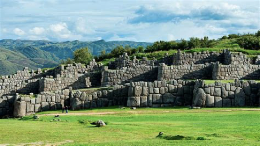
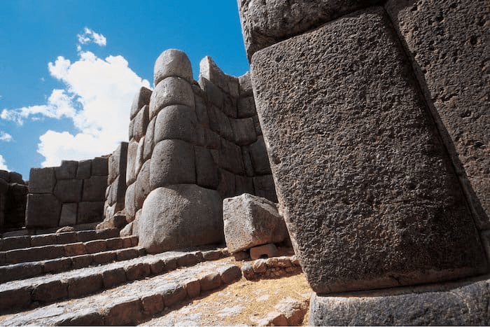
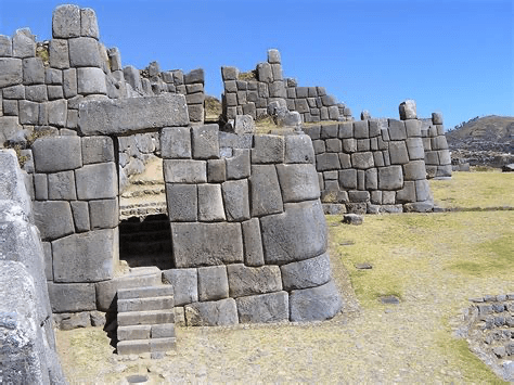
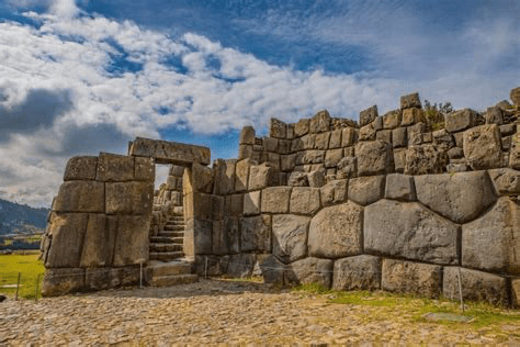
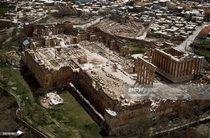
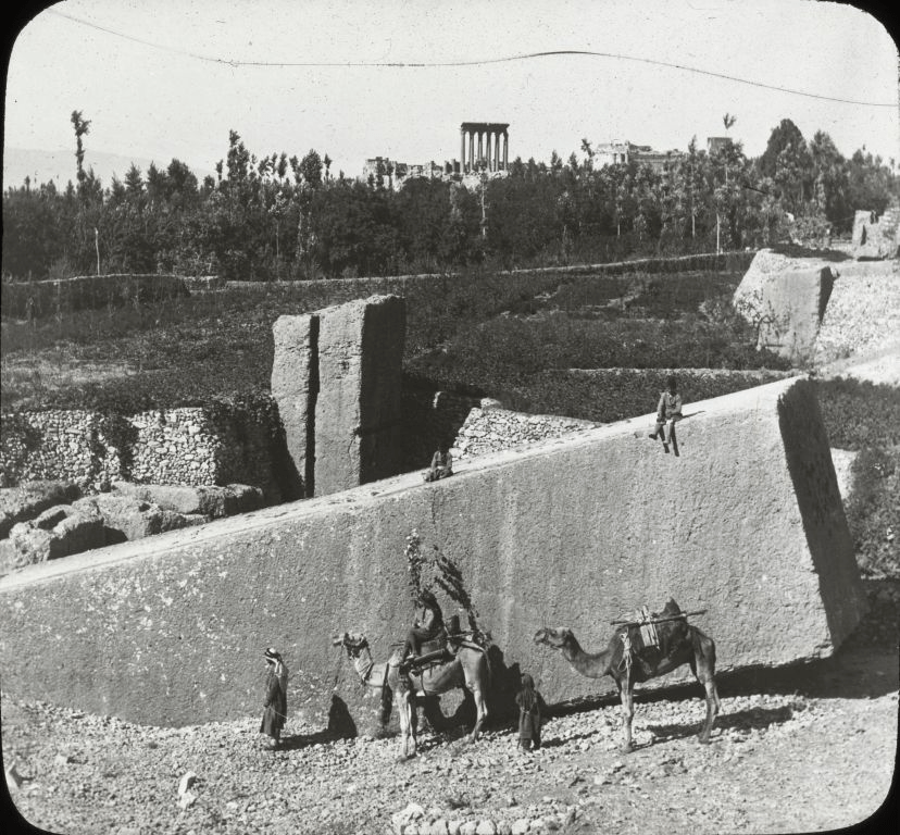
This writer particularly enjoyed researching a recent article concerning unexplained mysteries and was surprised at not only how much satisfaction was gained in putting it together, but also the level of interest shown by readers – Article: The Top Ten Unexplained Mysteries of all Time. In a similar vein, an article by Ancient Code, entitled: Five Archaeological discoveries no one can explain, April 2022, is the inspiration for this article. We will investigate the same five discoveries, of which three of them this writer wasn’t even aware. As with the previous article where two additional mysteries to the original ten were included; it is hoped to add two further discoveries of considerable interest to the five we will study – the equally intriguing sites of Sacsayhuaman in Peru and Baalbek in Lebanon.
We have touched upon the Giza Pyramids and the Sphinx previously, though it is the intention to write an in-depth article on both of these enigmas in the future – refer articles: The Pyramid Perplexity; and Appendix VII: Moses, the Exodus & the Red Sea Crossing – Fabrication or Fact? Like wise, briefly mentioned were the hidden settlement at altitude of Machu Picchu, or the ‘Lost City of the Incas’ situated high up in the Andes Mountains in Peru, as well as the giant buried statues on Easter Island – Chapter XXVII Abraham & Keturah – Benelux & Scandinavia.
What these structures have in common is an advanced intricacy of design, construction and purpose as well as being monuments of monolithic proportions, seemingly, or rather more pointedly, glaringly out of place within the orthodox paradigm presented for the world in which we live. This article logically follows Antartica: Secrets of the Lost Continent of Atlantis. As the legacy of the antediluvian epoch is reflected in the gigantic structures built in the age after the global cataclysm in 10,837 BCE according to an unconventional chronology – refer article; The Younger Dryas Stadial: Ending of the Earth… Beginning of the World.
Ancient Code: ‘All over the world, experts have found countless puzzling monuments, artifacts, and places that have remained a mystery ever since their discovery… these findings literally rewrite history as we know it. Countless theories have been proposed throughout the years trying to explain… them, however, not even the best scholars can agree on the purpose, reason and building process of… these… structures… we [will] take a look at FIVE discoveries that still continue to baffle experts.’
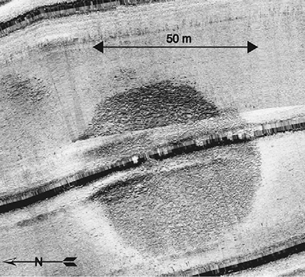
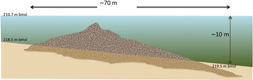
I. Massive Stone Mound beneath the Sea of Galilee
Beneath the Sea of Galilee in northern Israel lays a conical structure comprised of ‘unhewn basalt cobbles and uncut boulders.’ Its weight is estimated to be 60,000 tons (heavier than most modern warships), rising nearly thirty-two feet (10m), with a diameter of approximately two hundred and thirty feet (70) – longer than the length of a Boeing 747. Owen Jarus, Live Science, April 9, 2013, states: ‘To put that in perspective, the outer stone circle of Stonehenge has a diameter just half that with its tallest stones not reaching that height.’
A reoccurring theme in the structures we will investigate is the baffling question of how the builders ‘managed to transport the megalithic blocks of stone. The closest basalt outcrop was a few hundred metres from the site. The stones used are one to two metres in width and weigh up to two hundred pounds [90 kg].’
This shot of the Sea of Galilee was taken near the old city of Tiberias. The newly discovered structure is located just to the south
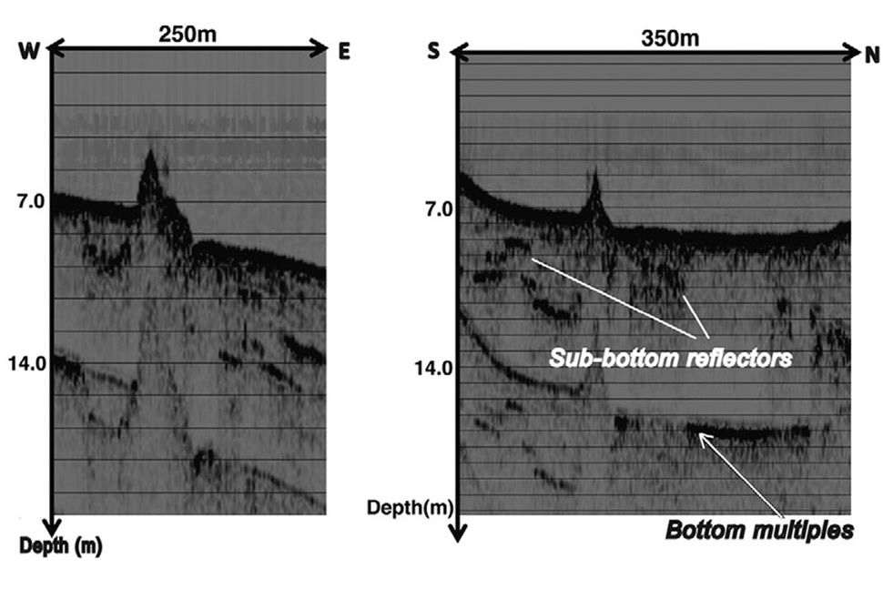
‘Archaeologists argue that judging by what they have been able to see, its builders belonged to a “complex and well-organized society”…’ The structure looks like a giant rock cairn (rocks piled on top of each other) used to mark burials. Whether this was its intended purpose is open to question. It was first detected in 2003 from a sonar survey off the southwest portion of the sea, located some five hundred meters (1600 ft) off the coast and nine meters under the surface. Divers who investigated the structure, wrote in the International Journal of Nautical Archaeology:
“Close inspection by scuba diving revealed that the structure is made of basalt boulders up to 1 m (3.2 feet) long with no apparent construction pattern,” the researchers write in their journal article. “The boulders have natural faces with no signs of cutting or chiselling. Similarly, we did not find any sign of arrangement or walls that delineate this structure.” Their opinion is that it was built on land and covered as the water level rose. “The shape and composition of the submerged structure does not resemble any natural feature. We therefore conclude that it is man-made and might be termed a cairn.”
The use of Compressed High Intensity Radar Pulse (CHIRP) provided researchers with additional information; indicating its “western face is somewhat steeper than the eastern part.”
Jarus adds: ‘Researchers list several examples of megalithic structures found close to the Sea of Galilee that are more than 4,000 years-old. One example is the monumental site of Khirbet Beteiha, located some 19 miles (30 kilometers) north-east of the submerged stone structure… It “comprises three concentric stone circles, the largest of which is 56 m [184 feet] in diameter.” This dating is conservative, with the cairn likely being far older. Underwater archaeological excavation is required in the hope of finding artefacts which could assist in determining the structure’s date and its purpose.
On our journey, there has been a mysterious common thread regarding circular monuments – where we can now add cones – which are ‘strangely, intriguingly, consistently and uniquely, replicated in the layout of Stonehenge; Plato’s account of the geographic configuration of Atlantis; crop circles; the rings of both Saturn; and the recently discovered, Super Saturn’ – Chapter XXII Alpha & Omega; and article, Antartica: Secrets of the Lost Continent of Atlantis.
During the third millennium BCE, the city of Bet Yerah (or Khirbet Kerak), was one of the biggest sites in the vicinity – located about a mile to the south of Galilee’s cone shaped mound – with researcher Yitzhak Paz saying: “It… [was] the most powerful and fortified town in this region and, as a matter of fact, in the whole of [ancient] Israel.”
A rock cairn comprises a human-made pile or stack of rough stones raised for a purpose. Either as a marker of some kind, such as a landmark; a memorial; a monument; a ceremonial ground; or as a prehistoric burial mound. Typically found on a hilltop or skyline, they can also be a navigational aid. ‘The word cairn stems from the Scottish Gaelic: càrn [ˈkʰaːrˠn̪ˠ] (plural càirn [ˈkʰaːrˠɲ] ).’
As this structure is sizeable, it may not be a burial ground, just as pyramids are not tombs. Its stature signifies a monument designed to be a. seen; b. remembered; and c. lasting. While the Galilee Mound is not as intricately sophisticated in its design, it still required considerable effort in its construction. Archeologists agree that the monument was of great importance to the people who built it.
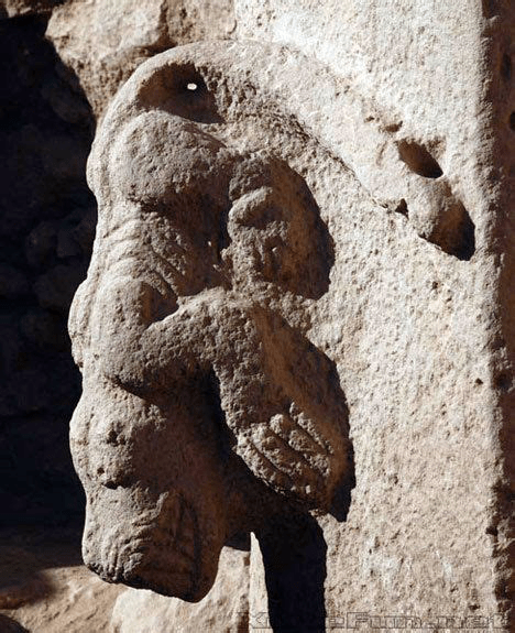
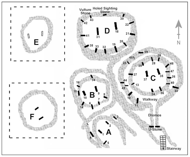
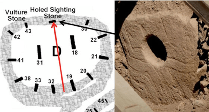
II. The Cochno Stone
A coincidence arises in that as the word cairn is from the Scottish Gaelic, the next unexplained archaeological mystery is the Cochno Stone in the foothills of the Kilpatrick Hills of West Dunbartonshire in Scotland. It is a short walk from the Faifley housing estate and a twenty minute drive from Glasgow.
The Cochno Stone is an enigmatic slab of sandstone discovered in 1887 by the Reverend James Harvey. When the stone was discovered, it remained buried for decades to protect it from vandalism.
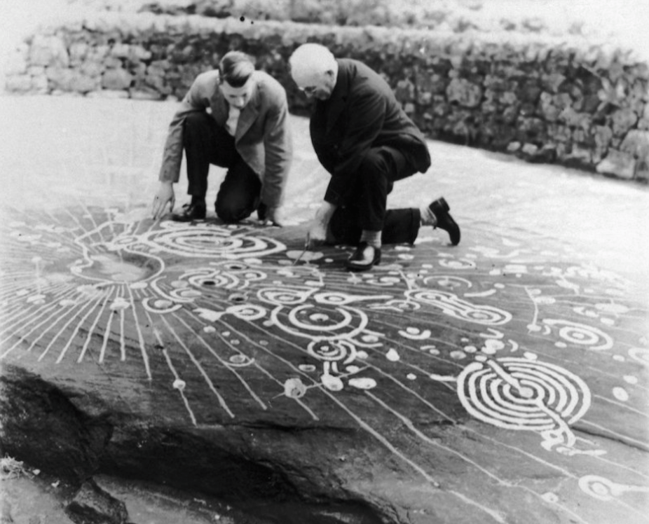
Interest in the site was ignited ‘in the 1930s when an account of the site in the Proceedings of the Society of Antiquaries of Scotland caught the attention of the eccentric and tireless amateur archaeologist Ludovic Maclellan Mann. He had already undertaken various excavations of Bronze Age sites in and around Glasgow and had a particular interest in the cosmological meaning of prehistoric rock art. In 1937, the profusion of weird symbols on the Cochno stone inspired in him a burst of well meaning but questionable creativity: he painted the rock surface in various colours. He picked out the cup-and-ring marks in white and covered the stone in a spectacular yellow linear grid of his own devising to try and capture its original cosmological and geometric meaning’ – The Conversation, September 14, 2016.
The huge gritstone outcrop is domed in the middle and features about ninety carefully carved indentations – consisting of domes, lines and rings across an area of almost 100 square metres – considered to be one of the finest petroglyph sets not just in Scotland, but in the world. ‘A petroglyph is an image created by removing part of a rock surface by incising, picking, carving, or abrading, as a form of rock art.’ The Cochno Stone has been conservatively dated to five thousand years old, though an older origin is probable. The name Cochno means ‘little cups’ in Gaelic and it is also known as ‘the Druid Stone’ or Whitehill 1.
Ludovic Mann [right] and a colleague studying the site in the 1930s
The Conversation continues: ‘Mann’s work brought media attention to the stone and soon visitors came flocking. Over the next couple of decades, their numbers kept increasing as urban Glasgow crept closer. By the early 1960s, the Cochno stone had become a popular place for local people and children to hang out. There was a growing fashion for visitors to carve marks and names into the soft rock, and lots of people were walking on the surface.’ It then became a well kept secret ‘… thanks to a decision in 1965 by the then Ministry of Works to bury it beneath tons of soil and stone.’
The stone was buried for conservation reasons, to protect it from further damage and to prevent people from adding their own carvings onto it; ensuring it would remain preserved and frozen in time. Fifty years later, beginning in 2015, the Cochno Stone was unearthed again. With the plan to ‘digitally and photographically record the stone and then create an exact replica [which could] be placed nearby. This [would] allow the real Cochno stone to be reburied and… rest in peace.’
Dr Kenny Brophy who specializes in urban archaeology, with a team of students from the University of Glasgow Archaeology Department, lead the excavation and ‘described the experience of seeing the stone for the first time in 51 years as a “once in a lifetime opportunity. The Cochno Stone is something I had heard about as a boy, historically it is well documented, but I was not able to see it until now.”
No consensus has been reached among archaeologists or scientists on the meaning of the intricate symbols found on its surface. Is the stone an altar where ceremonies were held, with the indented carvings acting as receptacles for liquids used in rituals? ‘Researcher Alexander McCallum proposed that the Cochno Stone is a map showing other settlements in the Clyde Valley.’ Or is it a map of the Earth or even the sky above? Some experts consider it a rendition of an ancient cosmic map, delineating planets and stars. The detailed markings are reminiscent of crop circles on a larger scale, which have been invariably ‘attributed to extraterrestrial civilizations’. Researchers have even suggested that the slab is in fact a portal; symbolising life, death and rebirth.
The hypnotic appeal of the carvings reminds the viewer of the geoglyphs in Peru, known as the Nazca Lines. Similar slabs have been discovered in the north of Spain, Greece, Mexico and in India. The scale of the stone’s carvings lends itself to being part of the legacy of the ancient enigmatic builders in our distant past.
If the stone slab is an elaborate map of the heavens, then deciphering the stone is a priority. The data could be fed into the applicable computer program and viewed against which time period the constellations match. This may not reveal the date the stone was crafted, but a significant event in arcane history. Conversely, what if the Cochno Stone actually marks a future event?
III. The Inga Stone
The third unexplained archaeological discovery in Ancient Code’s article, is the ‘mind-bending’ Inga Stone in the middle of the Inga River in the northeastern Brazilian state of Paraiba. It is believed to date to at least six thousand years ago, though it is conceivably far older. The Inga Stone or Pedra do Inga in Portuguese, is also known as Itacoatiara, do Ingá – meaning stone of Inga in the the Tupi language – and covers an impressive area of two hundred and fifty square metres. It is a horizontal construction one hundred and fifty-one feet (46m) long and up to twelve and a half feet (3.8m) high. The Inga stone displays myriad carvings yet to be deciphered, such as cryptic hieroglyphs of the more than four hundred engravings.
Researchers have identified several carvings as human figures, fruits, animals and geometric shapes; but of most interest, are engravings of the Milky Way galaxy and the constellation of Orion – Articles: Thoth; The Pyramid Perplexity; and Chapter XXI The Incredible Identity, Origin & Destiny of Nimrod. Archaeologists concur that the detailed engravings have been performed with minute precision and superb technique by skilled craftsmen. Raising serious questions whether the native Indians who lacked metal tools are the creators of the images.
Fertilization cycle of the flower of the angiosperm and the same cycle shown by the engravings on the stone
Ancient Code: ‘The Inga Stone is a geological formation from Gneiss (a common and widely distributed type of rock formed by high-grade regional metamorphic processes from pre-existing formations that were originally either igneous or sedimentary rock.) It is often foliated (composed of layers of sheet-like planar structures). The foliations are characterized by alternating darker and lighter colored bands, called “gneissic banding”).’
Brazilian researcher Gabriele D’Annunzio Baraldi has studied the encrypted messages in depth resulting in his theory that the carvings are proof of an unknown ancient technology. Baraldi opines the ‘rock represents the story of the universal flood, written in a language very similar to the Hittite, spoken in the second millennium BC in present-day Turkey.’
One source claims: ‘Many symbols of the Inga’s monolith are similar to those found in Turkey, in ancient Anatolia of the Hittites. A series of inscriptions speak of a “borders war” between two sovereigns of [Mesopotamian] origin. Another story tells about a terrible volcanic eruption. The ashes covered a stone city on the Atlantic coast, similar to what happened in Pompeii and Herculaneum.’
According to researcher Yuri Leveratto… ‘the message written in the Pedra do Ingá could be written in Nostratic – a large-scale language family, which includes many of the indigenous language families of Eurasia…’
The Inga Stone is an artistically designed complex, yet not unique for the geometrical style is replicated in other Brazilian engravings but admittedly, none are as famous and interesting as the Inga Stone.
Certain researchers have postulated that the engravings of the Inga stone were created by the Phoenicians, which is wholly incorrect – Chapter XXIII Aram & Tyre: Spain, Portugal & Brazil; and Chapter XXVII Abraham & Keturah – Benelux & Scandinavia. Others consider the aborigines of Easter Island, which has substance, as symbols of the Inga Stone show a degree of stylistic resemblance to symbols found at Easter Island with both of them representing curved style geometry. Researchers caveat that this is the only similarity found between them and does not necessarily mean a connection between the cultures. Alternatively, researchers have proposed the Inga Stone is evidence of ‘extraterrestrial contact.’
Tamas Varga: Could the horizontal line carved above the figures denote the water level of the river bed during a certain period of the year?
What is known is that the Inga stone is related to celestial phenomena as depicted by several constellations on its surface. Ancient Code: ‘In 1976 the Spanish engineer Francisco Pavia Alemany began a mathematical study… whose first results were published in 1986 by the Instituto de Arqueología Brasileira.
The author identified on the surface of the Ingá stone what he described as the most extraordinary known archaeological record of the variation of the solar orthography throughout the year. The symbols are materialized by a series of bowls or “capsular” and other petroglyphs engraved on the vertical surface, which by way of a graduated limb form a “Solar calendar”, on which a gnomon would project the shadow of the first solar rays of each day’ – Article: The Calendar Conspiracy. ‘The Safor Astronomical Association published in 2005 a synthesis of this work in its official bulletin Huygens Nº 53.
Later, F. Pavia continued the study of Ingá rock, focusing this time on the recording of a series of signs inscribed on the rocky surface of the channel itself, where a great number of “stars” can be observed that can be grouped into “constellations.” Both the “capsular” and the “constellation” records, in themselves, give Ingá great value, but the coexistence of both in the same reservoir gives Ingá an exceptional [archaeo-astronomical] importance, which is why many authors refer to the Inga Stone as one of the most under appreciated monuments on the surface of Earth’ and “an exceptional archeoastronomy monument, like no other in the world.”
As with the Cochno Stone, a deciphering of the constellations, for instance Orion, may provide a valuable date, which again may relate to an important occurrence and not necessarily to when the Inga Stone’s engravings were first carved. Though unlike the Cochno Stone, the Inga Stone may be recounting more than one story or significant event.
IV. Gobekli Tepe
The fourth unexplained archaeological discovery of the five listed in Ancient Code’s article is the potentially history changing site of Gobekli Tepe, located in the Germus mountains of southeastern Turkey. Göbekli Tepe (Go-Beck-Lee-Tep-E), is translated as ‘Potbelly Hill, Belly Hill’ or ‘Hill of the Navel’ in Turkish and ‘Girê Mirazan’ or ‘Xirabreşkê’ in Kurdish. The archaeological ruins atop a limestone plateau six miles from ancient Urfa, were first uncovered in the 1960s, though their significance was not truly realised until 1994.
The site has been brought to the attention of a wider audience, in large part to the program series presented by investigative journalist Graham Hancock on Netflix: Ancient Apocalypse. While Hancock continually divides opinion with his views on an alternate ancient history for human kind; Gobekli Tepe has opened Pandora’s Box for the archaeological evidence on arcane history. Causing an adamant re-writing of pre-history to press vigorously at the firmly locked door of mainstream historians and orthodox scientist’s explanation of mankind’s early ancestors.
Its re-discovery has raised countless questions about the actual evolution of civilisation and the existence of advanced and complex societies tens of thousands of years ago. Thus challenging the gradual ascent of an upward curve from the past till the present, by revealing a wave which goes up and down repeatedly in tandem with civilisations rising, falling and rising again.
Graham Hancock has invested special interest in Gobleki Tepe for good reason, as it is believed to be twelve thousand years old. This is meaningful to Hancock and researchers of a similar view, for it supports an advanced civilisation shortly after the global cataclysm approximately one thousand years earlier – Article: The Younger Dryas Stadial: Ending of the Earth… Beginning of the World.
By standard chronology, Gobleki Tepe predates Stonehenge by some 6,500 years and the Pyramids at Giza by 7,000 years. Of course, before Pandora’s Box even began to open ajar, the issue of the dating of Stonehenge and of the Great Pyramid has concerned this writer. For the Giza complex reveals a different degree of design and construction which does not remotely compare with the megalithic structures which are the subject of this article. Hence a future article will specifically address the Great Pyramid and its origin – The Pyramid Perplexity. Though the essence being, while the Giza pyramids are still younger than Gobleki Tepe, they are far older than currently dated.
As the Inga Stone and Cochno Stone are plausibly older than archaeologists have accounted for, so too is Stonehenge. Thus Gobleki Tepe being dated to between 9,600 for the oldest stratum to 8,200 BCE is not a surprise at all. The site merely fits in with Stonehenge, the Great Pyramid and other mysterious architectural monolithic buildings situated around the globe. As we have noted a circular pattern in ancient and modern anomalies previously, there are other commonalities to discuss as we progress, which link the ancient megalithic constructions to a single, related culture and time frame. Experts in their fields are left scratching their heads as to who designed and built all these mysterious structures, for they either ignore or reject, myth, legend, tradition, ancient texts and scripture for the missing pieces of the jig-saw puzzle that is humanities past.
The construction of Gobekli Tepe began circa 9600 BCE during the Würm Glacial Age, after the Great Deluge in 10,837 BCE which inundated the Earth – refer article: The Younger Dryas Stadial: Ending of the Earth… Beginning of the World. So it is ironic that the most recent widespread cataclysm to decimate portions of the planet, including the Black Sea Catastrophe occurred nearly nine thousand years ago circa 6,700 BCE. Causing the thriving Gobekli Tepe civilisation of three millennia duration to be mysteriously abandoned – refer article: Antartica: Secrets of the Lost Continent of Atlantis and Appendix IV: An Unconventional Chronology. It was at this time that Ireland and Great Britain once connected with Doggerland, became islands and with Scandinavia split off from the rest of Europe as part of the continental shelf sank under the sea.
Stephan Roget states that the structures that make up the site are incredibly well-preserved, allowing archaeologists to study them in something similar to their original condition. He says: ‘Part of the reason for the remarkable preservation of Göbekli Tepe is due to the climate in Turkey, but another major factor is… that many of the temple sites appear to have been backfilled before being abandoned.’
This is due to the fact natural burial through sediment building up is unlikely for the location; as hilltops do not collect sediment because they are places where the soil is lost and not where it is added. ‘This allowed the structures to remain protected from the elements as the centuries wore on…’ So much so that the megalithic structures have remarkably retained their original form, design, architectural elements and decorative craft works.
Christopher McFadden provides alternative reasons for burying the site aside from an ensuing catastrophe: ‘… the monuments on top of Gobekli Tepe were buried on purpose… it could have been buried to keep it safe for people in the future… [or] if a new religion or people replaced it, the site may have become seen as a place of sacrilege or taboo and was duly “memory holed”… If the place was a religious sanctuary, another… reason could be that the burial was part of a process to make the place less holy. In many cultures, things or buildings that are thought to have supernatural or divine power must be destroyed or changed in some way when they are no longer needed.’
Ancient code: ‘The main structures of Göbekli Tepe are a series of three rectilinear structures which are located below the surface, defined by dry-stone walls, and containing multiple decorated T-shaped pillars. The stones were used mainly as support for the roof, although it cannot be excluded that these had a symbolic purpose.’ Göbekli Tepe is considered the world’s first temple by archaeologists, historians and scholars alike. Most of this ancient site still remains buried.
‘Whoever built it, made sure the complex would survive… thousands of years, by backfilling the various sites and burying them deep under [ground]. So far, excavations and geomagnetic results revealed that there are at least 20 stone circles… on the site.’ Each circle site has been constructed with a similar design, but with slightly differing qualities.
‘All of the pillars at Göbekli Tepe are t-shaped and range in height from 3 to 6 meters [10-20 ft].’ The pillars weigh several tons, with estimates ranging between seven and ten tons; which would have made ‘bringing them to the central location a Herculean task. That’s to say nothing of placing large stone blocks on top of them.’
Today’s technology would have issues moving and positioning the pillars of Göbekli Tepe. It has been suggested a minimum of five hundred individuals would have been required to move and position the massive pillars. Yet in a world reeling in the aftermath of a global cataclysm, filled with chaos and consumed by self-preservation, how were these people organised and by whom? ‘Mainstream scholars argue that the building proves… Göbekli Tepe required quarrying experts, transport specialists, planners, and ritual overseers.’ The organisation required in building the site means its constructors possessed an already established society and hierarchy. Therefore, it remains a profound mystery how ancient man at this time, managed to accomplish the monumental feat of transporting and placing into position the massive stones at Gobekli Tepe.
The anthropomorphic pillars were carved from quarries in the adjacent limestone plateau. It is assumed that stone and bone tools were used, but only because of a rigid held paradigm for this period. For after ’13 years of digging’ according to Ancient Code, ‘archaeologists investigating the ancient site have failed to recover a single stone-cutting tool.
No one has been able to understand how ancient mankind, which was believed to be incapable of such [feats], erected some of the greatest stone-works on the planet… [and it] bothers mainstream scholars… they have failed to unearth a single stone cutting tool from the ruins of Göbekli Tepe.’
As the heat prevents archaeologists from digging in the summer months, only five percent of Göbekli Tepe has been unearthed. Imagine what finds may lay waiting within the fifteen metres of accumulated sediments, as more of the site is excavated? Geophysical surveys conducted in 2017, found more than two hundred obelisks and fifteen more ‘temples’ buried beneath the Earth. Gobekli Tepe is not alone either, for around a dozen other sites of similar age are under excavation in the ‘Stone Hills’ area, which extends for about one hundred square kilometres.
Roget: ‘The pillars, along with their top [stones]… might be hiding a design secret… Some of the stone blocks on top of the pillars have what appear to be human faces carved into them… [so] that the pillars are actually stylised depictions of human beings… the covering of the human form with depictions of [elaborate drawings of] animals [and intricate animal statues carved right onto the pillar’s surface] might be a clue into the belief system of the people who constructed Göbekli Tepe.
According to experts, foxes, snakes, wild boars, cranes, [and] wild ducks are the most commonly depicted animals’ – Article: Thoth. Andrew Curry adds: ‘… Gobekli Tepe’s pillar carvings are dominated not by edible prey like deer and cattle but by menacing creatures such as lions, spiders, snakes and scorpions. “It’s a scary, fantastic world of nasty-looking beasts.”
Roget: ‘The skilled architectural style seen in the construction of its many “temples” is seriously impressive, and would be in any era. The craftsmanship seen at Göbekli Tepe is thousands of years ahead of its time, and dates back… long before such construction should have been possible. The manpower, engineering, and project managing required for such an endeavor all seem unfeasible, given where human civilization was understood to be at the time’ [and] ‘shouldn’t have been possible without a sophisticated social structure already in place. Humankind may, unfortunately, never know who the brilliant minds behind Göbekli Tepe actually were.’
Yes, how could humanity so soon after the flood have been able to construct such an impressive site? In fact how did ‘they’ construct all the impressive buildings and monuments around the world, so quickly, so expertly and on such grand scales? Even more ironic then that the ‘potentially world-changing discovery of Göbekli Tepe’ during the 1960s was not recognised by University of Chicago and Istanbul University anthropologists. ‘In fact, it was wrongly assessed as being a “medieval cemetery,” and… subsequently ignored for half a century due to its apparent lack of potential. Klaus Schmidt, a German archaeologist, was the individual who decided to give it another look. Analysis of the site has been going on ever since, but archaeologists remain baffled by it…’
A temple or burial site is suggested for the apparent lack of a better alternative, even though no graves have been found; yet the site is so large – spread over an area of nine hectares – with palpable astronomical features, Gobleki Tepe likely had a more practical or meaningful function than a religious one, such as an observatory, a vault for knowledge, as well as a symbolic landmark.
Curry elaborates on the site’s function: ‘The site, Schmidt argued, was a ritual centre, perhaps some sort of burial or death cult complex, rather than a settlement. That was a big claim. Archaeologists had long thought complex ritual and organised religion were luxuries that societies developed only once they began domesticating crops and animals, a transition known as the Neolithic. Once they had a food surplus… they could devote their extra resources to rituals and monuments. Gobekli Tepe, Schmidt told me, turned that timeline upside down. The stone tools at the site, backed up by radiocarbon dates, placed it firmly in the pre-Neolithic era. More than 25 years after the first excavations there, there is still no evidence for domesticated plants or animals’ – refer Chapter I Noah Antecessor Nulla. ‘And Schmidt didn’t think anyone lived at the site full-time. He called it a “cathedral on a hill”. If that was true, it showed that complex ritual and social organisation actually came before settlement and agriculture. Ritual and religion, it seemed, launched the Neolithic Revolution.’
This is an extremely important point, for it is a clue to who the builders were and how and why they were able to perhaps place importance in constructing a non-essential for survival complex, ahead of domesticating crops and animals. More recent excavations have complicated Schmidt’s view who died in 2014; while not necessarily contradicting him.
Curry: ‘Work on foundations needed to support the site’s swooping fabric canopy required archaeologists to dig deeper that Schmidt ever had. Under the direction of Schmidt’s successor, Lee Clare, a German Archaeological Institute team dug several “keyhole” trenches down to the site’s bedrock, several metres below the floors of the large buildings. The digs revealed evidence of houses and year-round settlement, suggesting that Gobekli Tepe wasn’t an isolated temple visited on special occasions but rather a thriving village with large special buildings at its centre.
The team also identified a large cistern and channels for collecting rainwater, key to supporting a settlement on the dry mountaintop, and thousands of grinding tools for processing grain for cooking porridge and brewing beer. Clare said. “It was a fully-fledged settlement with permanent occupation”…’
McFadden: ‘In 2021, researchers from the German Archaeological Institute in Berlin learned over… four years that the people who built these old buildings ate vast pots of porridge and stew made from grain that the ancient people ground and processed on a nearly industrial scale. The clues from Gobekli Tepe show that ancient people used grains much earlier than was thought, even before there was evidence that these plants were domesticated. Rather than a centuries-long building project inspiring the transition to farming, Clare and others now think Gobekli Tepe was an attempt by hunter-gatherers [to cling] to their vanishing lifestyle as the world changed around them. Evidence from the surrounding region shows people at other sites were experimenting with domesticated animals and plants – a trend the people of “Belly Hill” might have been resisting.’
Thus Gobekli Tepe appears to have been originally built by those who were not reliant on domesticated crops and animals, but unlike the residents of nearby sites, were not transitioning to domesticated crops and farming. Coupled with this, there are a lot of animal bones within the ruins, confirming that the people who lived there were proficient hunters. If so, this adds support to the identity of the original builders and community which may have lingered at Gobekli Tepe.
Curry: ‘Joris Peters, an archaeozoologist from the Ludwig Maximilian University in Munich, specializes in the analysis of animal remains. Since 1998, he has examined more than 100,000 bone fragments from Gobekli Tepe. Peters has often found cut marks and splintered edges on them – signs that the animals from which they came were butchered and cooked. The bones, stored in dozens of plastic crates stacked in a storeroom… are the best clue to how people who created Gobekli Tepe lived. Peters has identified tens of thousands of gazelle bones, which make up more than 60 percent of the total, plus those of other wild game such as boar, sheep and red deer. He’s also found bones of a dozen different bird species, including vultures, cranes, ducks and geese.
“The first year, we went through 15,000 pieces of animal bone, all of them wild. It was pretty clear we were dealing with a hunter-gatherer site,” Peters says. “It’s been the same every year since.” The abundant remnants of wild game indicate that the people who lived here had not yet domesticated animals or farmed. But, Peters and Schmidt say, Gobekli Tepe’s builders were on the verge of a major change in how they lived, thanks to an environment that held the raw materials for farming. “They had wild sheep, wild grains that could be domesticated – and the people with the potential to do it,” Schmidt says. In fact, research at other sites in the region has shown that within 1,000 years of Gobekli Tepe’s construction, settlers had corralled sheep, cattle and pigs. And, at a prehistoric village just 20 miles away, geneticists found evidence of the world’s oldest domesticated strains of wheat…’ – refer Chapter I Noah Antecessor Nulla.
World History Encyclopaedia describe Gobekli Tepe’s enclosures in detail. The site is broken down into three chronological levels, I, II and III, which represent the main phases of construction and its use. Level I being the most recent and III the most ancient and deepest level.
Layer III is fascinatingly, the ‘most sophisticated level at Göbekli Tepe, a fact which poses some interesting questions: this is a site that in terms of artistic endeavour, construction, and concept seems to go backwards rather than progressing with the passage of time.’ So that Level II is far more basic and Level I represents thousands of years of abandonment and later agricultural use. Level I still produces relevant finds, though they have been affected by erosion and farming.
The overall size of the Göbekli Tepe site is considerable, yet the ancient core being excavated is modest in size and represented by four enclosures identified by lettering, A to D, designating the order of their discovery. ‘In level III, the oldest levels, each enclosure is characterised by different thematic components and artistic representations, and the early groups of enclosures are roughly circular in shape.’
The first area excavated was Enclosure A, also known as ‘the snake enclosure’ because depictions of snakesdominate the carvings on the T-pillars. ‘These are, in places, extremely intricate including one (pillar no. 1) which depicts a group of tightly packed snakes contained in what appears to be a net or wicker basket, set above a wild sheep or ram. The leading edge of the stele has three carved snakes moving downwards and one snake moving up. All the snakes carved at Göbekli Tepe are carved in a downward motion except for this single example [below].
The snakes are shown as short, thick creatures with broad flattened heads – typical of snakes which inhabit the Urfa region today, including the common Levantine viper’ – Chapter XXXIV Dan: The Invisible Tribe. ‘It is interesting to note that the snake holds a very powerful position in the mythology of Anatolia… Along with the snake, images of the fox are a consistent feature and possibly the fox has some totemic value for important members of this culture although, unlike the snake, the fox does not appear to have survived with a significant folkloric role in the wider region…’
‘Another pillar depicts a grouping of an auroch (a very large and now extinct bovine), a fox, and a crane, positioned one above the other in what may represent a narrative of some description. This is a thought-provoking narrative because the depiction of the crane is anatomically incorrect if the carver was depicting what he actually saw in the wild, as the knees of the crane articulate backwards in the same fashion that a human knee does. Any member of a hunting and gathering society would know from an early age that a bird’s knee articulates forward, and with a long-legged bird such as a crane, this forward movement is very marked indeed. What in fact may be depicted here is a human dressed as a crane. Could this be a hunting scene or possibly a depiction of a dance to invoke the attributes of the creatures being depicted?’
‘This anatomical puzzle is repeated elsewhere. The central pillars in Enclosure A do not have the anatomical features such as arms that we see on other pillars at this site and elsewhere but the animal depictions are particularly vivid. Nor do the pillars have any obvious structural purpose.’
‘Enclosure B is in the shape of a rough oval measuring about 10-15 m (north/south) and about 9 m (east/west) and has a constructed terrazzo floor. This enclosure is called the ‘Fox Pillars Building’ because the image of the fox predominates. The two central pillars [within the additional seven pillars shaped in a circular wall] each have a life-sized fox carved [in low relief] on them, both facing inwards and given their posture, in mid-leap. But interestingly on one of the stones, the fox appears to be pouncing upon a small rodent-like creature that was etched into the pillar at a later date [below].’
‘Enclosure C is dominated by superb renderings of wild boar and birds. Curiously, snakes are completely absent from this enclosure and appear to have been replaced in terms of use and positioning by images of the boar. Along with the two central pillars, there are 11 in the inner circle and, so far, eight in the outer circle; several may have been removed prior to the site’s burial. This construction is a little different in that the enclosure is built as a series of up to three concentric circles, one could even describe it as a sort of spiral.’
‘At some point after the burial of Enclosure C, a large 10 m diameter pit was dug in the central area of the enclosure and both standing central stones were smashed into several pieces. It is impossible to know the circumstances of this episode of iconoclastic vandalism and it is repeated elsewhere at Göbekli Tepe. It has been determined that the violence of this attack was considerable because the eastern pillar was cracked apart by an intense fire. The reconstruction of the western pillar from fragments of the original is adorned with a life-sized fox relief on the inward face in mid-leap southward towards the entrance. The eastern pillar, most of which is missing was adorned with a bull on its inward face. It is fortunate that the violence was only directed at the central pillars because around the perimeter wall of Enclosure C are to be found some of the highest quality stonework at Göbekli Tepe including an extraordinary high relief (Pillar 27) of a free-standing feline above a wild boar [below].’
‘The enclosure is built onto the plateau’s surface on the natural bedrock.’
‘Enclosure D is referred to as the Stone Age Zoo because of the wide variety of animal imagery. The dominating feature of this enclosure is the massive pair of central T-shaped stele, clearly intended to represent human figures and monumental in scope. They face south and are set on an ornamental pedestal, one of which is decorated with what appear to be ducks, and they stand at an impressive height of 5.5 m. Both standing pillars have arms clasped at the belly just above a decorated belt and a fox pelt loincloth with the tail hanging down at the front. The pillar standing eastwards has a life-sized fox in the crook of its right arm leaping to the south. But significantly there are no facial features. Apart from the belt and loincloth, both figures have what could be described as neck adornments which are clearly symbolic.’
‘This enclosure also has, as one of its perimeter stones, the most discussed, and possibly disturbing set of Göbekli Tepe images of all. This is pillar no. 43, the Vulture Stone [below]. The bizarre images on this pillar include, on the left-hand side, a vulture holding an orb or egg in an outstretched wing. Lower down there is a scorpion, and the imagery is further complicated by the depiction of a headless ithyphallic man. The enclosure is also built on natural bedrock which was levelled and smoothed to construct the central pillars’ pedestals and floor.’
‘There is [a] further enclosure, Enclosure E, which is about 100 metres east and slightly south of this grouping of enclosures. Nothing remains except the floor plan and foundation sockets for the central pillars. The floor is carved directly from the bedrock. Just adjacent to the enclosure there are some carved depressions which may be small cisterns carved from the rock; there are other larger examples found along the ridge of Göbekli Tepe. There are no springs in the vicinity, so water supply would have been a problem. There is also a grouping of cup-like depressions carved into the rock which are replicated at other Neolithic sites in the regions, but there are no real theories as to what they may have been for.
All the enclosures at Level III were filled in prior to the constructions on Level II. It is unclear why this was done, but there seems to be a conscious ‘decommissioning’ of the structures at Level III because some pillars were damaged or moved in an organised and controlled manner, while some pillars seem to have been removed entirely. Small artefacts remained, and statues were left in situ but toppled. Some of the tops of the pillars in Enclosure C are completely broken off. The tops of the intact central pillars have carved, cup-like depressions. It appears that when the Level III structures were buried, just the tops remained above ground and these cup-like depressions were carved once burial was complete.
Once again, the purpose of this is speculative, but receptacles for votive offerings or candles are a reasonable suggestion. With the construction and use on Level II, people were clearly using the site and would have been aware of the buried enclosures, the tops of which were protruding just above the surface, evidence of the convocation of standing stones just below. It is also reasonable to conclude that, although buried, the ancient enclosures still played a role of sorts in the ritual life of the people who continued to build and gather here.
One cannot be absolutely precise but it would seem that Level III, original construction around 9,500 BCE, was buried in phases after hundreds of years of use. The content of the material used to fill the enclosures in is a huge source of hard data. The composition of the in-fill material is simply refuse produced by hunting, food preparation, and consumption mixed in with in-fill material which included the residue of construction, stone working, thousands of flint tools, and the remnants of tool manufacture. The spoil tells us some important things about these people. The tools themselves, in the absence of the archaeologist’s basic dating tool, pottery, can be used to produce a broad cultural and chronological context in which data from other sites can [be] used to produce rough dates.
Level II is a different environment both conceptually and artistically. It is evident that the society and the culture are undergoing an important series of changes while important cultural markers remain. The enclosure spaces are far smaller and much more modest while decorations are simpler and are executed with less skill. They are also far more numerous and are constructed, almost in a jumble of competing floor plans, on top of Level III and sometimes cutting into Level III. They are certainly considerably less ambitiously monumental than before. This is possibly a society that has exhausted itself both economically and spiritually with Level III. It may be evidence of a transitional period before the abandonment of Göbekli Tepe and the evolution of more settled societies, such as the one at Çatalhöyük in the Konya Plain which is dated from about 7,500 BCE.
However, speculation aside, the most elaborate of these now more modest rectangular enclosures is the so-called Lion Building, identified by the carving on one of its principle stones. While probably still a purely cult or religious site with no evidence of domesticity, the enclosures are small and in many respects resemble the domestic buildings in other places such as Nevali Çori. It could be that economic and cultural changes are reflected in construction patterns here.
Over the 2013/14 CE season, archaeologists were uncovering another enclosure, Enclosure ‘H,’ about 250 m away from the original Level III excavations and on the other side of the hill towards the northwest. This is referred to as the ‘North West Depression’ and, at first glance, looks almost to mirror the original existing excavation. Also built on Level III, this enclosure possesses good-sized central stele set in an oval-shaped structure. As with Enclosure C, representations of wild boar seem pre-eminent. The enclosure, like all the others, was buried after its useful life. However, somebody, as with Enclosure C, took the time and effort to excavate a pit, locate the central standing stones…and destroy one (the other one still awaits investigation). Why?
Clearly what connects Enclosures C and H, and possibly enclosures yet to be discovered, are design (oval and with an accessing staircase), level (age), and artwork, but above all, these two enclosures are connected by identical acts of desecration carried out long after the enclosures were buried!
‘These acts of desecration would suggest a number of possible scenarios none of which necessarily exclude the others. Clearly the act of burying enclosures on Level III and the evolution of the structural design changes seen on Level II indicate a conclusion of a lifecycle for these structures, and a change of political and economic, although not cultural or religious, fundamentals. The question of deliberate, targeted, and heavy destruction in enclosures but continued site use suggests a continuity of belief for a considerable period of time but with major changes in the power dynamics of the society represented at and by this extraordinary site.
… theories contributed by non-academic and ‘alternative’ writers of popular books about the origins of Göbekli Tepe and its builders… are understandably concerned with the amazing and very photogenic remains on Level III… [and] range from an ancient civilisation of amazing complexity via vaguely biblical references to, quite literally, the stars.’
In an article entitled, Gobekli Tepe – Temples Communicating Ancient Cosmic Geography, March 8, 2013, Paul Burley comments: ‘The sacred relationship between Earth and the cosmos is expressed by the circular architectural form as well as the chiseled ornamentation found at Gobekli Tepe. The structures at Gobekli Tepe are generally devoid of subdivided space other than what appear to be few peripheral hallways or storage areas. Rather than a temple of worship with a common area separated from a sacred space such as an alter or place of offering, the temples at Gobekli Tepe have the appearance of undivided open, circular structures except for two T-shaped pillars placed off center within each structure and aligned generally in a northeast-southwest direction. The open, rounded shape is similar to a modern day arena or even the Roman coliseum where spectators observed games from peripheral seating while participants were located on the central floor area of each structure – like theatre in the round.
The temples are located on a prominent hill overlooking a broad valley. The site provided unobstructed views of both Earth and the heavens. Yet the site lacks a source of water. This fact alone shows that the development served a function of greater importance than mere secular comfort. The circular shape of the temple buildings reflects a natural, organic form. The arena-like structures would have been intended for ritual or ceremonial purposes, observation of the cosmos, and allowing a relationship to build between the human occupants and the world.
Essentially the sidewalls of the temples are like mid-sections of spheres in contact with Earth below and the cosmic dome above. Standing at floor level in one of the temples we place ourselves symbolically at the center of the world. At night we can look up and see the moon, planets and stars. We might perceive constellations that help us orient ourselves with the night sky. We can envision the paths of the planets, Moon and Sun crossing the sky. Those paths form a band extending across the cosmos. It is a pathway we call the ecliptic. We can also observe the Milky Way stretching across the night sky, its bulge of stars surrounding the galactic center in the vicinity of the well-known constellations of Sagittarius and Scorpio. However, different cultures perceive different constellations. It is reasonable to assume that builders of Gobekli Tepe did not necessarily envision the same constellations as Sumerians did thousands of years later, or the Greeks who were responsible for many of the constellations we think of today. It is fortunate that the temples were buried so soon after construction, for the cosmology developed by their builders is preserved and communicated to us today, eleven millennia later.’
World History Encyclopaedia: ‘The site is clearly orientated… [as] the Level III enclosures are orientated southwards… down the Plain of Harran from where the people might have approached…’ – Chapter XXVI The French & Swiss: Moab, Ammon & Haran. ‘Even today, the most logical approach is from the south. It is possible that this southern alignment faces a processional approach. After the abandonment of Level II, we see nothing happening at Göbekli Tepe other than the slow evolution of Level I, which represents the establishment of a rugged agricultural and semi-nomadic life across the environment we see today, with minor contributions during the Roman, Byzantine, and Islamic periods and which hid the drama of the numerous and silent convocations of monolithic beings just below the surface.’
Andrew Collins discusses proposed orientations for the twin central pillars in the key enclosures. Collins is one of the world’s foremost experts on Göbekli Tepe; first visiting the site in 2004. Collins has been investigating its Pre-Pottery Neolithic culture for over twenty years and is the author of various books which feature the subject. He comments: “… directly between the T-shaped heads of the pillars, is a very distinct pecked hole. Left and right of this hole are short vertical lines that make the image resemble the rectangular holed standing stone positioned centrally behind the twin central pillars in Göbekli Tepe’s Enclosure D.”
“This was something pointed out by my colleague Hugh Newman moments after Matthew Smith’s own dramatic discovery in Sanliurfa Museum in September 2015. A similar holed stone is seen in exactly the same position next door in Enclosure C. Yet this example (officially designated Pillar 59) is on its side and fractured across its circular aperture. In both cases the holed stones are located in the north-northwest section of the enclosure’s retaining wall at a position that reflects the exact alignment of its twin central monoliths.
This suggests that these standing stones, with circular apertures around 25-30 centimetres in diameter bored centrally through their widest faces in order that someone standing within the structure could gaze through their openings, had formed a key role in the religious beliefs and practices of the Göbekli builders. Indeed, their positioning would indicate they acted as the structure’s altar or holy of holies, forming a bridge or point of connection between the liminal space created by the enclosure’s interiors and the otherworldly realms and supernatural forces thought to exist beyond the physical world” – Article: Belphegor.
“Although the late Professor Klaus Schmidt… never commented on these holed stones seen in two of the most accomplished enclosures so far uncovered at Göbekli Tepe, he did pass comment on the fragments of strange stone rings found at the site (one of which is now on display at Sanliurfa Museum. These, he suspected, had been placed in the walls of now lost enclosures and acted as seelenloch, a word in his native German language meaning “soul hole”.
Seelenloch are found in connection with a large number of megalithic dolmens of Neolithic and later Bronze Age manufacture from Ireland in the West across to India in the East, with by far the greatest concentration existing in the North Caucasus region of southwest Russia. These take the form of circular apertures centrally bored through the structure’s entrance façade. Generally, these openings, which like the examples at Göbekli Tepe are usually between 25 and 40 centimetres in diameter, are too small to enable a person to pass through easily.
Shamanistic practices in various parts of the world incorporate the idea of a symbolic hole, either in a rock, in the ground, within a tree, or in the roof of a yurt or tent, that enables their soul to leave their physical environment and enter the Upper or Lower Worlds while in altered states of consciousness. Very likely the soul holes in megalithic structures, like those seen at Göbekli Tepe, acted in a similar capacity.
That a pecked soul hole should appear between the twin pillars on the carved bone plaque found at Göbekli Tepe is a revelation, as it intensifies the already heated debate over the direction of orientation of its main enclosures. The existence of the soul hole stones, the fact that the carved relief on the twin central monoliths faces the entrant approaching from the south, along with the southerly placed entrances into the main enclosures, all strongly indicate that these prehistoric cult structures were aligned towards the north.
Some researchers of the ancient mysteries field have chosen to ignore these data and announce that the twin central pillars of key enclosures at Göbekli Tepe are directed south, their twin central monoliths aligned to target the rising of either the three belt stars of Orion (Schoch, 2014, 54-55) or the bright star Sirius (Magli, 2014). However, not only have these alignments been shown to be either dramatically flawed or, in the case of Orion, non existent (Collins, 2014, 77-80; Collins and Hale, 2014), but there are far better reasons to assume northerly orientations of key enclosures at Göbekli Tepe.
Both the mean azimuths of the twin central pillars in Enclosures C and D, along with the positioning of the soul hole stones, target the setting of the bright star Deneb in the constellation of Cygnus on the north-northwest horizon during the epoch of their construction, ca. 9500-8900 BC (Collins, 2014, 80-82).
The [cross-like formation of the] stars of Cygnus sit astride the Milky Way, exactly where it bifurcates or forks to create two separate streams known as the Dark Rift or Cygnus Rift. This area of the sky has been seen as an entrance to the sky-world [the source of life and creation] for many thousands of years, and seems even to be depicted within the ice age cave art at Lascaux in Southern France, created by Solutrean artists ca. 16,000 BC (Rappenglück, 1999). It thus makes sense why the Göbekli builders might have orientated key enclosures north towards this already ancient entrance to the Upper World, where access to the Milky Way – long seen as the river, road or path along which souls reached the afterlife – was located. From this constellation souls emerged into incarnation and here they would return in death” – refer article: DEATH: A Dead End or a New Beginning? “The route to Cygnus taken both by the souls of the dead and by shamans in trance states is known in North America as the Path of Souls death journey.
A northerly orientation towards the soul hole stones in the main enclosures at Göbekli Tepe is now supported by the discovery of the bone plaque displayed at Sanliurfa Museum. The manner in which its carved imagery clearly implies that the entrant’s eyes are drawn towards the soul hole, like those seen in Enclosures C and D, bears out this supposition, and supports the likelihood that the Milky Way, and in particular the Dark Rift and Cygnus stars, were of primary importance to the beliefs and practices of the Göbekli builders.”
Working with British engineer Rodney Hale, Andrew Collins established that the three main Pyramids of Giza not only reflect the astronomical positions of the three wing stars of Cygnus, but are aligned to them on the ground as well. The three pyramids are locked into the setting of these three Cygnus stars in the horizontal and vertical planes of all three dimensions.
The visual alignment of the same three stars, as seen from a vertical perspective, their astronomical positions corresponding with the geographical locations of the Giza pyramids.
Collins’ deduction that Gobekli Tepe was aligned with or focusing on a Northern orientation is of particular interest and ties in with this writer’s research on the Great Pyramid – Article: The Pyramid Perplexity. Collins is also correct in realising the positioning of the Giza pyramids do not align (entirely) with the stars in Orion’s belt as popularly taught amongst alternative history and New Age authors. Yet Collins’ proposal with the constellation of Cygnus may not be wholly correct either – refer article: The Pyramid Perplexity.
The theory that Gobekli Tepe was one of the earliest astronomical observatories in history as Andrews Collins hypothesises is gaining support outside of the mainstream. McFadden: ‘The rationale for this hypothesis tends to distill down to two critical pieces of evidence. The first is based on the fact that the location appears aligned with the night sky, notably [though perhaps incorrectly] with the star Sirius. Another contends that Gobekli Tepe’s carvings document a comet impact that occurred at the end of the Ice Age.’ The construction of Gobekli Tepe began after the Last Glacial Maximum and may explain why many of the images at Gobekli Tepe seem to indicate struggle and death.
Eric Betz: ‘Most of the pillars feature ornate carvings of animals, like snakes, foxes, wild boars, birds… Individual rooms… usually have one particular animal as its theme, which is why researchers suggested that the ancient hunter-gatherers were so-called [animists]. They believed all living creatures had spirits… [worshipping] them.’
It may not be a sign of worship per se, but of veneration instead. All physical life had been wiped out in the great Flood, accept those animals and DNA samples aboard the Ark – Chapter I Noah Antecessor Nulla. Therefore, after the disaster in 10,837 BCE, it would have naturally taken some time for animal life to flourish again – Article: The Younger Dryas Stadial: The Ending of the Earth… Beginning of the World. If Gobekli Tepe was initially constructed circa 9,600 BCE, it would make sense that while animal and bird species were breeding exponentially, they were still not as widespread as they are today. Their existence would not be taken for granted by those who lived after the Flood and had observed the slowish regeneration of the Earth.
The fact that wild animals in particular, were revered or remembered on the pillars and enclosures is not hard to fathom. An alternatively more plausible reason for their inclusion on the stonework, is the astronomical connotation of their images and symbolism relating to the constellations in the night sky.
‘Although many of the pillars focus on… a single animal, other carvings combine their art into a more complex motif. Gobekli Tepe’s Pillar 43 is the most prominent of these. This captivating pillar appears to feature a large vulture, other birds, a scorpion, and additional abstract symbols.’
Curry: ‘Danielle Stordeur, an archaeologist at the National Center for Scientific Research in France, emphasizes the significance of the vulture carvings. Some cultures have long believed the high-flying carrion birds transported the flesh of the dead up to the heavens. Stordeur has found similar symbols at sites from the same era as Gobekli Tepe just 50 miles away in Syria. “You can really see it’s the same culture,” she says. “All the most important symbols are the same.”
Pillar 43 or the Vulture column (lower left above), may serve as a kind of ‘smoking gun’ that the Earth underwent worldwide destruction. Phys.org and researchers with the University of Edinburgh: “The pillar was created by the people of Gobekli Tepe and now appears to have served as a means of commemorating a devastating event – perhaps a comet breaking up and its remnants crashing into the Earth, causing an immediate environmental impact around the globe and possible loss of life.”
It was in 2017, when two chemical engineers from the University of Edinburgh, caught the media’s attention, claiming they were able to connect the animal carvings on Gobekli Tepe’s Pillar 43 to the positions of various groups of stars in Earth’s sky many millennia ago. They had published a paper in the journal Mediterranean Archaeology and Archaeometry, where they argued that the Vulture column is a ‘date stamp’ [an asterism – meaning: a familiar star pattern] for a catastrophic comet strike 13,000 years ago.
This struck a cord, as scientists suspect a comet struck Greenland around this time, triggering the Younger Dryas Stadial. One of the engineers, Martin Sweatman: “It appears Gobekli Tepe was, among other things, an observatory for monitoring the night sky. One of its pillars seems to have served as a memorial to this devastating event – probably the worst day in history since the end of the Ice Age.”
A future article on the Younger Dryas event is planned, where we will return to Gobekli Tepe and the incredible significance it has with that remote epoch – refer article: The Younger Dryas Stadial: Ending of the Earth… Beginning of the World. Graham Hancock considers Gobekli Tepe to be a “profoundly astronomical site” and that it is an ancient constellation diagram which ‘shows the winter solstice against a backdrop of today’s modern sky.’ Hancock remarks:
“This is spooky and eerie, because it appears there’s overwhelming evidence that the people who made Gobekli Tepe had a profound knowledge of precession” – Chapter XXII Alpha & Omega. “And it appears that they deliberately sent forward into time – in this time capsule – a picture of the sky in our age.”
Paul Burley is of the same opinion: ‘From the archeological evidence gathered to date there can be little doubt that Gobekli Tepe symbolizes an ancient cosmology, with the architecture representing the world and the carved figures symbolizing important aspects of the sun, stars and other features of the night sky. One of the limestone pillars includes a scene in bas relief on the upper portion of one of its sides. There is a bird with outstretched wings, two smaller birds, a scorpion, a snake, a circle, and a number of wavy lines and cord-like features. At first glance this lithified menagerie appears to be simply a hodgepodge of animals and geometrical designs randomly placed to fill in the broad side of the pillar.
The key to unlocking this early Neolithic puzzle is the circle situated at the center of the scene. I am immediately reminded of the cosmic Father – the sun. The next clues are the scorpion facing up toward the sun, and the large bird seemingly holding the sun upon an outstretched wing. In fact, the sun figure appears to be located accurately on the ecliptic with respect to the familiar constellation of Scorpio, although the scorpion depicted on the pillar occupies only the left portion, or head, of our modern conception of that constellation. As such, the sun symbol is located as close to the galactic center as it can be on the ecliptic as it crosses the galactic plane.
What is important here is for some unknown reason the builders of Gobekli Tepe constructed a temple apparently highlighting a time 11,600 years in their future. Yet this scene is intentional. The symbolism is clear and in keeping with many mythologies describing this very same event – occurring at the very time we live in today!’ The figure below ‘illustrates the ecliptic crossing the galactic plane of the Milky Way near the center of the galaxy, with several familiar constellations nearby.’
Sky graphic using Stellarium 0.10.61
While the figure below ‘is the same view with the addition of the ancient constellations represented on the pillar.’
‘Note that the outstretched wings, Sun, bird legs and snake all appear to be oriented to emphasize the sun’s path along the ecliptic. Detailed analysis of the architecture at Gobekli Tepe is needed to further evaluate the scene carved onto the pillar. However, the similarity of the bas relief to the crossing of the ecliptic and galactic equator at the center of the Milky Way is difficult to reject, supporting the possibility that humans recognized and documented the precession of the equinoxes thousands of years earlier than is generally accepted by scholars at this time. Gobekli Tepe was built as a symbolic sphere communicating a very ancient understanding of world and cosmic geography. Why this knowledge was intentionally buried to ground level soon afterward remains a mystery.’ Unless the inhabitants had advance warning of an impending disaster.
Paul D Burley is an archaeo-engineer, geologist, researcher and the author of the The Sacred Sphere – where he explores sacred ‘concepts and cosmic consciousness through universal symbolism’. The book details many facets of circular pictographic symbols and ancient architecture representing the sphere. The book highlights ‘all sacred circular symbols throughout time have represented relationships between humans, the world, the cosmos, and the Creator as defined by each culture around the world. The book also defines the unique geometric structure from which all sacred geometries and sacred circular symbols are derived.’
There are weird aspects at Gobekli Tepe. The first, involves a strange fascination with collecting and modifying human skulls. While there are no human graves on the site, pieces of human remains have been discovered in the fill of buildings and the areas around them. Included in these piles were a series of partly preserved human skulls. The alterations are unique in that they have not been observed on sites from the same time period or location.
This was unexpected for researchers, to say the least and could point to the emergence of a skull cult in Anatolia and the Levant during the Early Neolithic which has never been documented before. Was Gobekli Tepe an important ritual centre or something more sinister?
The skulls have been removed after death and appear to have been given both exceptional care and special status in that decorations were added to their skulls, while being displayed around the site. It is not clear if these treatments were done as part of rituals within the monumental buildings themselves or if they were brought to the ritual centre from settlements in the region.
A. Intentionally decapitated human statue. B. A “gift bearer” holding a human head. C. Pillar 43 (“Vulture stone”) with low relief of an ithyphallic headless individual, one arm raised.
McFadden states: ‘The discovery of the human skulls in 2017 is fascinating enough… more evidence for the use of the site may be extracted by studying the actual columns and other artifacts… the T-shaped columns on the site famously have various animal-human hybrid depictions… more crucially… some of the reliefs… indicate the ritualistic decapitation of human bodies. One particular case (image C) shows a headless individual in the bottom right of the pillar (below the scorpion and [to] the right of the “bird’s head.” Other artifacts from the site… support the inhabitants’ fascination with heads. One small statue appears to show what has been interpreted as a “gift-bearer” carrying a disembodied head… another… [indicates] a human statue that has, at some point, been intentionally decapitated… it is clear the people at this site were very different from us today.’
Eric Betz: ‘Klaus’ team believes that one thing is clear about the pillars in general: They were built in a T-shape as a kind of stylized human form, like a person without a head. (… [and] like later peoples in the region [they] removed heads from buried bodies to employ them in rituals.) “This T-form is really some unique phenomenon of this culture of Gobekli Tepe and the surrounding settlements, and it’s not repeated anywhere else on our Earth and in any other culture,” Schmidt said… So, unlocking their meaning could help explain the entire site.’
A further creepy aspect is a nearby site called Karahan Tepe, which shares numerous characteristics and is referred to as Gobekli Tepe’s ‘sister site’. Hancock describes his impression: “I found this place eerie, unsettling and powerful.”
The undulating body of a serpent coils across the base of a water-channel
Karahan Tepe was discovered in 1997, though the first systematic survey was carried out later in 2000. The study ‘revealed basin-like pools carved in bedrock, and a considerable number of chisels… adzes, beads, stone pot fragments, grindstones, and pestles. The fact that arrowheads, scrapers, perforators, blades, and other stone tools made from flint or obsidian were [also] found… suggests that most people… hunted, gathered, or raised animals for food’ according to McFadden. This is in contrast with Neolithic settlements, which were based on farming.
Findings show that the site was used during the Pre-Pottery Neolithic period [from 10500-6500 BCE], the same period as Gobekli Tepe. Studies show Karahan Tepe resembles the Gobekli Tepe II layer and ‘both sites have 266 pillars with T-shaped architectural elements and animal reliefs…’
‘Karahan Tepe has more depictions of human beings than… at Gobekli Tepe, which might show that people were starting to see themselves as separate from animals… the people who lived there [also] buried the site and left it. Even more astounding is that Karahan Tepe is… not alone as a “sister site” to Göbekli Tepe. It is… considered part of a constellation of contemporaneous settlements that extends for more than 100 km and includes… at least [eleven]* other un-excavated sites.
Circular homes are part of a large ritual complex on the site. Structures for ceremonies have… been found cut into the bedrock. One of these structures is a rock-cut chamber with [eleven]* giant phalluses and a [striking humanoid] head with a snake’s body…’
Hancock: ‘The enclosure itself is entirely cut down into and carved out of solid bedrock. Ten of the pillars within the enclosure are also directly carved out of the bedrock to which they remain connected at their bases. The eleventh, notably curved, pillar is freestanding and rests in a shallow groove. Some of the archaeologists working on the site speculate that it might have been used to produce tones, like a tuning-fork or musical instrument – a suggestion that is enhanced by evidence that the enclosure once contained water (which could perhaps have been used to modulate tones) to a depth of up to a metre. There is a general assumption that the other pillars in the enclosure are phallic symbols and this may very well be true. However, consideration might usefully be given to an alternative possibility. Nearby Gobekli Tepe… has a very distinctive name, often translated “Potbelly Hill” but more accurately rendered as “Hill of the Navel.”
‘This invites us to consider the possibility that Gobekli Tepe was recognised as an Omphalos or “Navel of the Earth”, a notion found at other ancient sites around the world (Delphi in Greece, Cuzco in Peru, the Temple Mount in Jerusalem and Easter Island in the Pacific to name but a few) that are connected in myths and traditions to geodesy – the science of accurately measuring and understanding the Earth’s geometric shape and orientation in space. Could Karahan Tepe also have been one of these “navel” sites, and could the rock-hewn pillars represent not phalli but omphali?’ Hancock raises an interesting and valid point. It is worth noting that omphali look like phalluses. They could be one and the same thing, just as menhirs, obelisks, church steeples, skyscrapers, towers and even serpents all carry phallic symbolism.
‘Immediately visible from the entrance the most compelling mystery of Karahan Tepe is this inscrutable human face. Mounted on a sinuous, serpent-like neck it seems to thrust itself forward out of the bedrock.’ The face or rather head is human like, yet somehow inhuman and sinister beyond description. Is this head linked with the preoccupation with severed heads and skulls in Gobekli Tepe?
A disturbing coincidence is the Karahan Tepe face while not a dead ringer for the face on Mars (below), does instil a similar uncanny preternatural aura and one which is definitely not friendly – Article: The Pyramid Perplexity.
The persistence of snake imagery at both sites is indicative of a serpent cult, or perhaps a brotherhood of the snake. While the Brotherhood of the Snake has become a catch-all term to embrace just about any conspiracy one cares to mention and no tangible evidence supports its existence; the truth is that its does exist. It began when the Adversary rebelled; continued in the Garden of Eden; again when the Watchers descended to Earth; and its torch is carried by Establishment subsidiaries of a Luciferian nature such as the Illuminati – Articles: Principalities & Potentates: What they want… Who they are; and The Establishment: Who are they… What do they want?
The essence of the Brotherhood of the Snake is the seeking of the overthrow of the Eternal One’s rule as well as the destruction of the human race. In the interim, in the continued war against mankind, humanity is kept enslaved through corrupt governments, political systems and conflicting beliefs, whether religious or scientific.
Ascension Glossary states – emphasis mine: ‘The Brotherhood of the Snake secretly and methodically infiltrated the Atlantan Mystery Schools and [their] Great Libraries in order to acquire all of the Law of One and human… knowledge for themselves [and] intentionally confiscating the records… in their planned takeover of the earth… they were stealing knowledge crystals and meticulously copying over the… ancient written translations that contained the original… Founder… records, in order to use that knowledge as a consciousness weapon against humanity.
The Snake Brotherhood Kings during Atlantis made a secret pact called the Luciferian Covenant for the purpose of the total annihilation of the historical timelines and cellular memories of humanity, to wipe out all records of highly technological human civilizations that were naturally evolving and advancing human consciousness and authentic human culture. The eradication of all of the technology, memories, histories and identities during the advanced civilization of the Atlantian colonies on the earth, is a conspiracy enacted through a blood covenant made with the Illuminati hybrid humans that make up the Power Elite and answer to the Thothian Luciferian groups’ – Article: Thoth.
‘The goal was that the Thothian group behind the Brotherhood of the Snake would continually maintain control over how, what and when particular knowledge from the Founder Records would be disseminated to the masses and to slowly package it as a worldwide religious control mechanism. Essentially taking the Founder records and weaponizing them into a fear-based narrative that would be enforced by threats or shaming by some externally created authority, hidden behind the religious or dogmatic structure.’
Organised and militarised style of Psychological Warfare tactics are used ‘to further prey upon the spiritual and emotional desires of a primarily western Judeo-Christian population, to lead them into the False Ascension Matrix on the Astral Plane for soul capture during the death passage. The Luciferian Thothian groups currently transmit a range of twisted half-truths in ancient esoteric teachings of ascension to guru and seeker archetypes, that are purposely geared towards the consciousness enslavement of its audience. Many of the channeled transmissions are based in the information that was disseminated in the timeline of the Atlantian Mystery Schools, the Brotherhood of the Snake, which had acquired ancient written translations of stolen coded information in the Law of One records.
These records were accessed and translated by Thoth and then subsequently repackaged through the release of the EmeraldTablets. The Emerald Tablet transmissions into the New Age movement are heavily hijacked and embedded with Artificial Intelligence and mind control programming in order to attract those spiritually awakening with Atlantian or Mystery School memories, and then tag and track these groups for Mind control and spiritual oppression’ – refer articles: 33; Antartica:Secrets of the Lost Continent of Atlantis; DEATH: A Dead End or a New Beginning? and Chapter XXI The Incredible Identity, Origin & Destiny of Nimrod.
For anyone doubting the validity of this secret and invisible agenda, the primary plot of the Bible’s New Testament, is exactly this. A warning of its escalation and the Way of escaping its ramifications, was proclaimed when the Mediator between the Creator and humankind was sent to this Earth a little over two thousand years ago – Appendix VIII: When the Creator came to dwell with His Creation. The truth is truly stranger than fiction; the truth is really out there; and only the truth, will set one free – John 8:32.
Andrew Collins poses the following questions in May 2014 regarding Gobekli Tepe: Who built it, When and Why: ‘… Göbekli Tepe was constructed by a… population still in fear following a devastating cataclysm that nearly destroyed the world… it seems unlikely that those who came up with a plan to counter the innate fear of another cataclysm (something that visionary and writer Barbara Hand Clow so aptly calls catastrophobia) were the indigenous population. This appears to have been orchestrated by members of an incoming culture, composed of groups of shamans, warriors, hunters and stone tool specialists of immense power and charisma. Their territories, across which they traded different forms of flint, as well ashematite used as red ochre, stretched from the Carpathian Mountains in the west to the Russian steppes… in the east. More incredibly, anatomical evidence points to them being of striking appearance – tall, with extremely long heads, high cheekbones, long faces, large jaws, and strong brow ridges… So who were these people?’ – refer Nephilim & Elioud Giants I & II.
Collins states that the builders of Gobekli Tepe possessed a legacy of knowledge, where they believed in a ‘cosmic tree [refer article: Asherah] supporting the sky world [entrance] via the Great Rift – the fork or split in the Milky Way caused by the presence of stellar dust and debris – corresponding to the position in the northern heavens occupied by the stars of Cygnus, the celestial swan (a.k.a. the Northern Cross).’ As birds were symbols for astral flight, this was the manner in which a shaman could reach the sky world. The birds typically associated with this process in Europe, were the swan and in Southwest Asia, the vulture. The vulture being a primary symbol for death and transformation in the early Neolithic age; with both birds identified with the Cygnus constellation, according to Collins.
Thus the shaman could enter the sky world and aim to counter the actions of the ‘supernatural creature… responsible for cataclysms… This cosmic trickster was seen to take the form of a sky fox or sky wolf, embodied perhaps in the leaping foxes carved in relief on the inner faces of key pillars at Göbekli Tepe [such as in enclosure B]… All across Europe, and into Southwest Asia, accounts exist of supernatural foxes and wolves that have attempted to endanger the sky pillar supporting the starry canopy, an act that if achieved would have brought about the destruction of the world… whenever this supernatural creature returned to the heavens in the guise of a comet… it would be the shaman’s role to enter the sky world and counter its baleful influence, a primary motivation I see as behind the construction of Göbekli Tepe.’
In the context of numerology, the word fox – a symbol used prominently throughout Gobekli Tepe – comprises the letters f, o and x. There are only three out of the twenty-six letters in the (English) alphabet which have a numerical value of six. They are f, o and x, which thus equates to the number 666. Revelation 13:18, ESV: ‘This calls for wisdom: let the one who has understanding calculate the number of the beast, for it is the number of a man, and his number is 666.’
This is a misleading translation. The Greek word for beast is G2342 – therion, and can refer to a ‘wild, venomous’ or ‘dangerous animal’, as well as a ‘bestial man.’ It is more than a reference to a wild animal and implies one which is ‘brutal, savage’ and ‘ferocious.’ Importantly, the context of Revelation thirteen with chapter nine, reveals the beast to be of supernatural origin, such as an angel.
The word for ‘man’ is G444 – anthropos, and while its literal meaning is ‘man-faced’, that is a ‘male’ or ‘female human being’, it can be a reference for ‘animals, plants, God, Christ’ and yes, ‘angels’. In the context of an angel, it includes ‘the added notion of weakness, by which man is led into a mistake or prompted to sin with the adjunct notion of contempt or disdainful pity.’ The word for ‘his’ is G846 – autos, meaning: ‘him, he, his, her, she, they’ and ‘it’. Its usage includes: ‘himself, herself, themselves’ and ‘itself’.
Thus the use of the male noun and pronoun is perhaps not accurate. The verse could just as easily be written as: “… calculate the number of a monster [according to the New Testament For Everyone], for it is the number of an angel, and its number is 666.”
The number 666 is interesting in the context of the Beast deceiving the world, for the first two digits contain the prefix hex and the third number is the primary numeral six and hex in the Greek – G1803. The definition of hex in English includes ‘to bewitch, practice witchcraft on, a ‘spell’ and to ‘charm’ – Revelation 18:23, 2 Thessalonians 2:9-11.
Collins: ‘Yet there were clearly other reasons for the construction of Göbekli Tepe. Its stone enclosures served, most likely, as womb chambers, places where the shaman entered into a primal state, like that experienced before birth, after passing between the enclosures’ twin central pillars. These enormous monoliths… acted as otherworldly portals to invisible realms – true star gates in every sense of the word.
And their target: the setting down on the local horizon of Deneb, Cygnus’s brightest star, which marked the start of the Milky Way’s Great Rift, a role played by Deneb as early as 16,500-14,000 BC. At this time Deneb acted as Pole Star, the star closest to the celestial pole during any particular epoch. Even after Deneb ceased to be [the North] Pole Star around 14,000 BC, due to the effects of precession (the slow wobble of the earth’s axis across a cycle of approximately 26,000 years), its place was taken by another Cygnus star, Delta Cygni, which held the position until around 13,000 BC’ – refer pole star, article: The Pyramid Perplexity.
Collins: ‘After this time the role of Pole Star went to Vega [Alpha Lyrae, circa 12,000 BCE] in the constellation of Lyra, the celestial lyre. When around 11,000 BC Vega moved out of range of the celestial pole, no bright star replaced it for several thousand years. This meant that when Göbekli Tepe was constructed, ca. 9500-9000 BC, there was no Pole Star. It was for this reason that Deneb, and the Milky Way’s Great Rift, retained their significance as the main point of entry to the sky world, making it the primary destination of the shaman.’
Note that circa 9000 BCE Iota Herculis of Hercules was the North Pole Star.
Collins: ‘Standing stones erected in the north-northwestern sections of the walls in two key enclosures at Göbekli Tepe bore large holes that framed the setting of Deneb each night, highlighting the star’s significance to the Göbekli builders, and showing the precise direction in which the shaman should access the sky world.
Everywhere you look at Göbekli Tepe there is confirmation that its builders shared a sense of connection with the cosmos. From the strange glyphs and ideograms on the various stones, which include symbols resembling the letters C and H, to the twelvefold division of stones in the various enclosures, there is powerful evidence that these 11,000-year-old temples resonate the influence of the celestial heavens.
The H glyphs seem to relate to the shaman’s journey from this world to the otherworld, while the C glyphs are almost certainly slim lunar crescents signifying the transition from one lunar cycle to the next. Even the design of the enclosures appears to have cosmic significance. Invariably the structures are ovoid in shape, with a length to breadth ratio of 5:4, numbers that could hint at the Göbekli builders’ profound awareness of cosmic time cycles not usually thought to have been understood until the age of Plato.
Over a period of around 1,500 years twenty or more major enclosures were constructed within the gradually emerging occupational mound at Göbekli Tepe. Old enclosures were periodically decommissioned, deconsecrated and covered over, quite literally “killed,” at the end of their useful lives. New structures were built to replace them, but as time went on they became much smaller in construction, until eventually the cell-like buildings were no larger than a family-sized Jacuzzi with pillars no more than five feet (a meter and a half) in height. Somehow the world had changed, and the impetus for creating gigantic stone temples with enormous twin monoliths at their centers was no longer there.’
Rather the people had changed. The grandeur and sophistication of layer III was performed by the original builders and inhabitants, whereof Collins describes. Layer II is evidence that the original inhabitants had likely departed and for the want of a better description was constructed by Homo sapiens sapiens. For the original designers and inspiration for the works at Gobekli Tepe were not entirely human.
Collins: ‘Sometime around 8000 BC the last remaining enclosures were covered over with imported earth, stone chippings and refuse matter, and the site abandoned to the elements. All that remained was an enormous belly-like mound that became an ideal expression of the fact that the stone enclosures had originally been seen, not just as star portals to another world, but also as womb-like chambers, where the souls of shaman, or indeed the spirits of the dead, could quite literally journey to the source of creation, located somewhere in the vicinity of the Cygnus constellation. It was a concept dimly remembered in the name Göbekli Tepe, which in Turkish means “navel-like hill”.’
The final abandonment may have taken place later than Collins supposes during the early period of Peleg’s lifetime circa 7000 to 6700 BCE – refer Appendix IV: An Unconventional Chronology. This was an epoch of immense upheaval which coincided with the demise of Nimrod; the destruction of the Tower of Babel; and the global cataclysms such as evidenced in the Black sea and the Hudson Bay – Article: The Pyramid Perplexity.
Collins: ‘Even after Göbekli Tepe was abandoned, its memory, and those of the ruling elite behind its construction, lingered on among the Halaf and Ubaid peoples who flourished during the later half of the Neolithic age, ca. 6000-4100 BC.’ When civilisation and culture seemingly suddenly sprung up out of nowhere in Lower Mesopotamia and in Egypt. ‘Like their predecessors, they gained control of the all-important obsidian trade at places such as Bingöl Mountain and Nemrut Dağ, close to Lake Van.
Their elites, who would appear to have belonged to specific family groups, artificially deformed their already elongated heads, not only to denote their status in society, but also quite possibly to mimic the perceived appearance of great ancestors, seen to have possessed extremely long heads and faces. It is very possibly these great ancestors who are perhaps represented by the snake-or reptilian-headed clay figurines found in several Ubaid cemeteries [as shown below].’
Collins dances close to the truth regarding the mysterious identity of the Gobekli Tepe architects and its builders – refer article: Principalities & Potentates: What they want… Who they are; and Chapter XXII Alpha & Omega.
Collins: ‘The elite of the Halaf and Ubaid were… the forerunners of the god-kings who ruled the first city-states down on the Mesopotamian plain, which eventually became the civilizations of Sumer, Akkad, Assyria and Babylon. Their scribes preserved in cuneiform writing the ruling dynasties’ mythical history, in which the original founders… are known as the Anunnaki, the gods of heaven and earth. Their birthplace was said to have been the Duku, a primeval mound located on the summit of a world mountain called Kharsag, or Hursag…’ Collins equates the primeval mound with Gobekli Tepe and Bingöl Mountain which while not literally correct, could well be in a symbolic sense. ‘The Anunnaki are occasionally likened to serpents, reflecting the snake-like appearance of Göbekli Tepe’s ruling elite, as well as those of the later Halaf and Ubaid cultures.’
Credit is given to Andrew Collins for being closer to the truth than any other researcher in aiming to unravel the identity of the creators of the Gobekli Tepe compound. Though not a criticism of his excellent research overall, there are errors in the details. It has to be considered that the architects of sites such as Gobekli Tepe and its builders are two different entities or not the ones Collins supposes. Collins focuses on the Annunaki (or Watchers) as responsible for both enterprises and in the process inadvertently mixes their antediluvian exploits as described in the Book of Enoch with those after the great deluge such as at Gobekli Tepe. The answer to Gobekli Tepe’s construction may lay in a collaboration between these dark angels and their offspring, or entirely in the endeavours of their children (the formidablerace), who were the giant Nephilim – refer articles: Nephilim & Elioud Giants I & II.
Collins describes the Watchers as human angels, an oxymoron and as being ‘extremely tall, [wearing] coats of feathers, [possessing] visages like vipers (that is, extremely long facial features), and… [being] described as Serpents…’ Collins concludes that the serpent like Annunaki could be ‘Neanderthal-human hybrids’ – an incorrect juxtaposition. The Annunaki were akin to the Watchers, yet decidedly inhuman, fallen angels – 2 Peter 2:4-5. Their offspring, the result of unlawful relations with human women were angel-human hybrids – Genesis 6:1-4. Homo neanderthalensis was an earlier creation than Homo sapiens, but nether-the-less very much human – Genesis 1:26-31; 2:7-8, 15-25.
It is of note that Collins mentions the Anunnaki – which literally means: “Those who from Heaven to Earth Came” – in relation with Gobekli Tepe for it may strongly link the obsession of its architects and builders with animal symbolism; as prior to the Flood, the Anunnaki and or the Nephilim had experimented with interbreeding with animals. This had resulted in mixed breeds of creatures upon the planet to whom a soul would not stay. It is these beings who were the soulless ones often written about in channeled materials. Creatures such as minotaurs (body of a man, head of a bull), centaurs (upper body of a man, lower body of a horse), werewolves (human transformation into a wolf) and a great number of other examples. There was a necessity for these to be destroyed so that the whole of creation would not be fouled by their presence on the planet.
Collins continues in stating that ‘local tradition asserts that Bingöl was… the source of the fourth river [the Pison] of Paradise [in the biblical Eden]… [and] ancient writers record that the true source of the Tigris was in the same region. Armenian tradition… speaks of Bingöl Mountain being the place of the gods and the summit of the world from which emerge four great rivers that carry the waters of life to every part of the world. [This] points toward Bingöl Mountain being not only the “birthplace” of the Anunnaki, but also the site of the mountain of Paradise, and the place of descent of the Watchers in the book of Enoch.’ Though in reality, the Annunaki did not originate on this Earth; the Garden of Eden was not in Anatolia and the Watchers did not originally descend on Bingol Mountain – refer Chapter XXII Alpha & Omega.
Hancock and Collin’s ideas on Gobekli Tepe’s astronomical potential and importance are pertinent. Whatever other uses the site builders intended, such as a ritual centre of death for instance, a cosmological gallery and observatory seems glaringly obvious, weighed against the vehement arguments of orthodox scientists, astronomers and archaeologists to the contrary. Could the circular enclosures and specifically between the two central pillars have been used as portals of some kind in aligning the physical realm with the spirit dimension as Collins alludes? Could the site have been a doorway for spiritual entities to cross. These questions cannot be dismissed out of hand.
Credence should be given to this line of reasoning as following the Flood, the Sumerian King Lists describe kingship being lowered from heaven: “… after the Flood had swept over the Earth, when Kingship was lowered from heaven…” The Anunnaki gods now found themselves living in a different dimension from humans, unlike prior to the Flood. So that a merging was required between the fourth dimension in which they resided with that of the third dimension where humans now found themselves.
The focus of temples changed to match the fact that the gods were not present in person to walk and talk with, as the earth plane was now only three dimensional. Just as humans usually cannot see fourth dimensional beings such as ghosts or astral entities unless they are psychically gifted – or whom have momentarily slowed their vibration to become visible – so too could ordinary men not see the gods their ancestors had once been able to interact with. Other forms of communication became necessary. Temples ceased from being the literal house of a god and became houses of worship. Man and his gods met in the temples, but in a different way so that the knowledge, rituals and beliefs which resulted are now called Religion.
As the gods in the post flood world still desired sex with human females, the uppermost levels of the temples – atop ziggurats – became twilight zones, an area where the third and fourth dimensions intertwined and mingled in order for the gods to be able to ‘descend’ again and have intercourse with third dimension human women. The god’s appointed women – the temple virgins or vestal virgins – who were kept in special houses adjoining the temple area. These virgin priestesses were chosen when very young; their diet was monitored; they were isolated from other polluting influences; they were guarded by eunuchs so there would be no temptation for them; and their degree of spirituality was carefully gauged to ensure their vibration could be kept high for their passage into this mixed dimensional zone.
The Anunnaki needed the use of wormholes to travel the great distances across space from planet Earth to their home world (originally) in the constellation of Taurus. The gods would leave and so the priestesses burned eternal fires at their altars, waiting for the next return. The possibility of that return became less and less real to each succeeding generation, setting up an archetype of waiting for the gods to come back, which various cultures still carry till today. As the Flood became a distant memory so too did the gods; becoming only legends and then myths because they were no longer present physically as they had been in the ancient past.
Jon Landseer in a series of lectures delivered at the Royal Institute of Great Britain to the society of Antiquarians in 1822, called those early post flood times an era “when Astronomy was religion” and vice versa. He asserted that the calendar was related to the zodiacal “mansion” of the Bull, [home of the Anunnaki’s own planet] and that the transition to Aries was associated with “a mystifying conjunction of the Sun and Jupiter in the sign of Aries, at the commencement of the great cycle of intricate (celestial) revolutions” – refer article: The Calendar Conspiracy.
Landseer believed Greek myths and legends connecting Zeus or Jupiter with the Ram and its golden fleece, reflected the transition into Aries, of which he calculated that such a determining conjunction of Jupiter and the Sun in the boundary between Taurus and Aries had occurred in the year 2142 BC. Landseer’s dating accords with an unconventional chronology; where the age of Taurus lasted from 4490 BCE to 2330 BCE, with the age of Aries following from 2330 BCE to 170 BCE.
Was it precisely at this moment when the Anunnaki left for the last time to catch the next wormhole home? The reason they went was not just because it was time to go home. Nor just because they got burned out on inter-dimensional sex. Though this does relate to the actual issue: did they really leave?
The density of this planet traps souls or spirits here with its net of sexual lust and desire and so the endless pursuit of sexual fulfilment has degraded the vibrational status of the Earth until it can now really go no lower. This is it for the planet, the bottom of its moral descent. So for these sub-space entities from the fourth dimension, having relationships with third dimensional partners takes its toll, depleting their energies. Logically, if partners are not on the same frequency or energy band, it will lessen the higher energy of the two.
While this type of relatively direct contact ended, the Anunnaki did not leave and have instead maintained a continuous relationship with humanity. Brinsley Le Poer Trench, the editor of Flying Saucer Review, detailed that an otherworldly message appeared for the first time in a 1947 issue of Fanatic Stories written by an author under the pseudonym ‘Alexander Blade.’
The ‘Anunnaki’ begin with the claim:
“We are already here, among you. Some of us have always been here, with you, yet apart from, watching, and occasionally guiding you whenever the opportunity arose. Now, however, our numbers have been increased in preparation for a further step in the development of your planet: a step of which you are not yet aware…”
“You will find records of our presence in the mysterious symbols of ancient Egypt, where we made ourselves known in order to accomplish certain ends. Our principal symbol appears in the religious art of your present civilization and occupies a position of importance upon the great seal of your country” – the all-seeing eye atop the Great Pyramid of the United States of America” – refer article: The Pyramid Perplexity.
“We have left you certain landmarks, placed carefully in different parts of the globe, but most prominently in Egypt where we established our headquarters upon the occasion of our last… public appearance. At that time the foundations of your present civilization were ‘laid in the earth’…”
Marcus LiBrizzi expands on the Anunnaki’s mode of operation and their agenda:
‘The latest incarnation of the vampire… reveals the critical, revolutionary heart of the vampire legend. The Anunnaki form of the vampire… has moved… from the cloak of darkness to the light of day.
… according to [David] Icke, the Anunnaki have been ruling earth in different guises and from different dimensions. Through genetic engineering, the Anunnaki have manipulated the evolution of humans as a slave race. “The Anunnaki created bloodlines to rule humanity on their behalf,” he writes, “and these … are the families still in control of the world to this day.”
‘The interbreeding of the rich and powerful (primarily… the European aristocracy and the Eastern Establishment of the US) is not done for reasons of snobbery but rather, “to hold a genetic structure that gives them certain abilities, especially the ability to ‘shape-shift’ and manifest in other forms.”
Working with these crossbreeds are full-blooded Anunnaki, some physically present on earth, others influencing individuals and events psychically from… “the lower fourth dimension”. Forming a “Brotherhood” or secret society network, the Anunnaki have effectively “hijacked the planet”.
The recurring motif in the discourse on the Anunnaki is vampirism. “While vampire beliefs are varied,” writes James Craig Holte, “certain elements of the vampire myth are consistent. The most important are the inability to experience death, the importance of blood, and the sexual connection between vampire and victim.”
‘Other structural similarities between the traditional vampire and the Anunnaki include shape-shifting, hypnotism, and links to secret societies. The Anunnaki, like traditional vampires, enjoy eternal or extenuated life spans. Icke claims that, “the fourth dimensional reptilians wear their human bodies like a genetic overcoat and when one body dies the same reptilian ‘moves house’ to another body and continues the Agenda into another generation.”
One type of creature Icke describes is a reptilian “inside” a human physical body; “it seems that … the Anunnaki need to occupy a very reptilian dominated genetic stream to do this, hence certain bloodlines always end up in the positions of power. Other less pure crossbreed human-reptilians are those bodies which are possessed by a reptilian consciousness from the fourth dimension and these are people who psychics see as essentially human, but ‘overshadowed’ by a reptilian”. Crossbreeding to infuse reptilian genetics into human bloodlines, the Anunnaki gain the means to defy death, as we conceive it.
In respect to blood drinking… The Anunnaki drink blood, which they need in order to exist in this dimension and hold a human form. Embedded in this need lies another parallel between the Anunnaki and the figure of the vampire – the power to shape-shift (from reptilian to human form for the Anunnaki, and usually from vampire form to that of bat or even mist for the traditional vampire). But the Anunnaki also feed off fear, aggression, and other negative emotions’ – Article: Principalities & Potentates: What they want… Who they are.
Holte: ‘Thus, while blood is needed as a vital life force, the Anunnaki are also addicted to “adrenalchrome,” a hormone released in the human body during periods of extreme terror. Rather than sucking the blood directly from the necks of their victims, the Anunnaki apparently slash the throats of their victims from left to right and consume the blood out of goblets… the origin of the vampire stories are the blood drinking and “energy sucking” rituals of the Anunnaki.
In the sexual connection between slayer and victim, the Anunnaki also share another similarity with the traditional vampire. However, depictions of the Anunnaki… contain none of the erotic allure and seductiveness that distinguish many vampire texts. Instead, the sexual bond between the Anunnaki and their victims is characterized by violence – rape, murder, and Satanic ritual.’
“Satanism at its core is about the manipulation and theft of another person’s energy and consciousness… sex is so common in Satanic ritual because at the moment of orgasm, the body explodes with energy which the Satanists and the reptiles can capture and absorb.”
‘For Icke… the demons honored or appeased by satanic sex rituals are none other than the reptilian Anunnaki. Sex is also a fundamental tool of the Anunnaki mind control program and, more prosaically, it figures prominently as a means of blackmail. The picture that emerges is one involving vast networks of sexual abuse and ritual murder – graphic accounts of satanic practices at the playgrounds for world leaders, such as the Boemian Grove, a 2,700 acre compound north of San Francisco – mass graves for victims drained of their blood and libidinal energies – and the cultivation of sexual crimes to create an energy field that nourishes these rapacious ETs’ – article: Lilith.
‘There are other shared traits between the traditional vampire and the Anunnaki, for example, the role of secret societies. One of Icke’s chief contributions to the discourse on the vampire lies in his immersion of this figure into a vast web of clandestine organizations, from ancient mystery schools and cults like the Brotherhood of the Snake to the Knights Templar and the Masonic Order, from global entities like the UN, the Trilateral Commission and the Council on Foreign Relations to drug cartels, satanic churches, and the Black Nobility. A keystone in this architecture of conspiracy is the Order of Draco, which conjures up the most famous of all vampires – Count Dracula – and underscores his demonic, draconian, and reptilian associations.’
“According to Laurence Gardner, the name Dracula means ‘Son of Dracul’ and was inspired by Prince Vlad III of Transylvania-Wallachia, a chancellor of the Court of the Dragon in the 15th century. This prince’s father was called Dracul within the Court” – refer KingCharles, article: The Life & Death of Charles III.
‘Finally, the Anunnaki share with the traditional vampire the capacity to hypnotize: Icke writes that reptilian bloodlines, “have the ability to produce an extremely powerful hypnotic stare, just like a snake hypnotizing its prey and this is the origin of giving someone the ‘evil eye.’
The pattern of circular enclosures in Gobekli Tepe reinforces the theme already noted and as observed for example on the Cochno Stone. It is central to the fifth discovery to be discussed next.
V. Stonehenge
Nota Bene
The original section which followed concerning Stonehenge has been removed. The material is reproduced in its entirety in the article ‘Stonehenge’ and is now available there for the interested reader.
VI. Sacsayhuaman
Ancient Code describe Sacsayhuaman – pronounced as sexy woman – as ‘one of the greatest archaeological mysteries on our planet.’ Ancient Code: ‘While mainstream scholars firmly believe [ancient megaliths were] created without the use of advanced technologies, millions of people around the globe maintain that not only were sites like Sacsayhuaman built thousands of years ago by advanced civilizations, but they also had in their possession now lost technologies that allowed them to build some of the most incredible ancient sites on the planet.’
‘The intricate, MASSIVE, interlocked walls of Sacsayhuaman are the ultimate evidence of advanced technology. Creating something like this today is nearly impossible, even with all of the [modern] technology that engineers and architects have at their disposal. The megalithic boulders of Sacsayhuaman were placed together with such precision that the site cannot be compared to any other similar complex on Earth.
In fact, the stones at Sacsayhuaman are so closely spaced that not a single sheet of paper could fit between the boulders. The precision at Sacsayhuaman, in addition to the size and weight of the rocks and their unmatched shapes, and the general design of the walls have puzzled scientists and experts for years. Sacsayhuaman remains one of the greatest archaeological mysteries of all time.’
Unlike Gobekli Tepe and Stonehenge which while incorrectly, could be attributed to a huge concerted effort by human manpower alone, Sacsayhuaman simply does not allow the luxury of denial for the palpable truth. Either entities clearly not from this world, possessing unknown and godlike technology constructed the site, or beings of extraordinary size and capabilities who have ceased to exist in our physical world, designed and built Sacsayhuaman.
The rule book concerning ancient history urgently requires rewriting, yet mainstream historians and scientists will continue to contend against this correction. Researchers such as Graham Hancock are paving the way as early pioneers for a reconstruction of mankind’s prehistory and in time the trickle of the stream of truth now, will become a surging river of greater acceptance and eventually an undeniable ocean of understanding.
In Gods of the New Millennium, 1997, Alan Alford describes the enormity of the undertaking in constructing the walled fortification: ‘The ruins of Sacsayhuaman occupy a ridge overlooking the city of Cuzco [in Peru]. The main feature of the site is a set of three parallel, zigzagging walls [measuring 1,500 feet long and 54 feet wide. The walls surround a paved area containing a circular stone structure that could be a solar calendar].’
‘These walls, when combined with the natural sheer drop on the opposite side, [create] a completely fortified area… The largest stones at Sacsayhuaman occur in the lowest wall, a magnificent 20 feet in height. where one stone in particular is estimated to weigh 130 tons. These zigzagging walls, more than 1,200 feet long, have rightly been called “one of the most astounding megalithic structures of the ancient world and have repeatedly amazed all that have seen them.”
‘The Spanish historian, Garcilaso de la Vega, recorded his impressions that the walls were: “… erected by magic, by demons and not by men, because of the number and size of the stones placed in the three walls… which it is impossible to believe were cut out of quarries, since the Indians had neither iron nor steel wherewith to extract and shape them.”
‘Leaving aside the enormous efforts which would have been involved in dragging more than a thousand stones several miles from the nearest quarry, let us [turn] to the theory of “scribing and coping”. In order to match the joints of the Sacsayhuaman stones in this way, many stones weighing 10-20 tons would have had to be propped up in mid-air while the scribing and coping was performed against the stone positioned below. Faced with such a dangerous and painstaking operation, the question which arises is not whether the Incas could have done it, but why did they bother? Why did they not use stones half the size? I… [am] forced to conclude that an advanced construction technology must have been available.’
Elizabeth Lunden explains the origin of the scribing and copying theory. How an architect sought to answer how the megalithic stones were intricately and perfectly aligned together: ‘[A]… plausible theory… submitted was developed by a man named John McCauley… a retired architect and construction manager, [who] researched ancient construction techniques for over 40 years. His theory states that the Inca probably used a system called “scribing”, or basically, “template-making”, to create the interlocking system of megalithic stones we see at Sacsayhuaman.’
‘… the Inca [would have] moved the huge pieces of rock up to the site and carved and polished them… on the hill. In order to create stones that fit so perfectly together, they would carefully measure the space they needed and create a wooden template.’
Lunden: ‘This template would then be applied to another stone… and the stone would be shaped and polished to match the template… this means that the Inca would have to be extremely accurate stonemasons. We know that they possessed a lot of knowledge of mathematics and science, and that they were very accurate at stone carving. Still, this theory seems… a little too far-fetched [for the Inca].
The stones at Sacsayhuaman are huge. The precision needed to create a wall, with no mortar, where [one] can’t even slip a piece of paper in between the cracks at any point, even with templates, chiseling, and polishing, would have been extremely difficult and taken an inordinate amount of time. The… problem with this theory is that the stone has been vitrified. Even with the cutting and polishing, the builders still would have had to fit these huge… stones into an equally megalithic furnace and vitrify them at temperatures upward of 1100 degrees. This, of course, would have messed with the precise carving… if the stones had been carved after being vitrified and polished… [one] would see obvious tool marks on the stone where the glass-like surface was cut away. Still, it’s the best theory… so far, and… the only one that doesn’t sound like a… conspiracy theory. Does that make it correct? Not at all.’
Alan Alford: ‘A similarly advanced technology seems to have been used on a rocky knell at Sacsayhuaman, opposite the zigzag walls. Here, we find the so-called “Inca’s Throne” where, for no apparent reason, a platform and series of steps have been carved with great precision into the hillside. The “experts” claim that the perfect angles and edges of the Inca’s Throne were finished off using small stones as precision tools.
However, when one sees the accuracy of this work first-hand, it seems ludicrous to suggest that such primitive methods were actually used. The smooth, polished faces of these steps, together with numerous other enigmatic niches around Sacsayhuaman, appear instead to have been machined using twentieth century technology.’
Sacsayhuaman’s cyclopean dimensions and colossal boulders inspire awe at the sheer scale and audacity of the unbelievable stone architecture. Ancient Code confirm: ‘The stone masonry present at Sacsayhuaman is incredible, with huge walls composed of rocks over 50 tons, squeezed together in such a way as if the rock literally melted, placed together like a puzzle, perfectly fitting into place.
Ancient Code: ‘This image [above] is incredible, observe the corner of this construction, the stone blocks seem bent, yet everything fits together perfectly, and there is not a chance that a single sheet of paper would fit between these incredible blocks of stone… [the] image [demonstrates] Sacsayhuamans’ stonemason abilities to shape these huge stones in a unique manner, creating bent corners… [also] seen in other places on the Planet, Egypt being one of those. Did ancient stonemasons from Sacsayhuaman really have the ability to soften rock?’ By ‘using a mysterious liquid derived from a plant’ and mineral disaggregation from the heat generated from a ‘series of complex mirrors and lenses to harness the sun’s rays to create enough heat to melt the stone…’
Due to the impressiveness of the site it is easily one of the most astonishing archeological complexes ever discovered. With its beauty and grandeur it has become an ‘all-but-compulsory’ must-see destination in Peru. The complex is located two kilometres north of the main square of the city of Cusco and is 3701 metres (12,140 feet) above sea level. It forms the highest part of the city of Cusco, covering an area of more than three thousand hectares, situated on a hill surrounded by huge mountains.
These thirteen slabs are called thrones or at least that is what tour guides explain them to be. The flat surfaces have been carved from extremely hard stone with exacting precision and detail.
According to Peru Hop: ‘Sacsayhuaman (also known as Saksaywaman or Saqsawaman) is a Quechua word that can be translated as: “Saqsay” – “Satisfy”, and “Huaman” – “Hawk”, meaning “the place where the hawk is satisfied”. It is believed that the complex was given this name due to the presence of the hawks, and legends tell of the Inca who fed a hawk that landed on his shoulders. Current theories argue that the complex served as a fortress as well as a ceremonial center but the truth is that no one is really sure exactly what Sacsayhuaman was before the Spanish invaded, at which point it was used as a fortress.’
‘There is another theory about the name of the structure. This theory claims that all of Cusco was laid out to form a puma shape when seen from above, this is plausible as the puma was a very sacred animal to the Inca people. If this is the case, Sacsayhuaman was in the place of the animals head. One of the translations of the word Sacsayhuaman is Puma, and that this animal is the one who [watches] and [takes] care of everything.’
Apparently, Inca ruler Pachacutec (1438-1471) after successful victories against the expanding Chanca Confederation, commanded his architects to redesign the entire urban trace of Cusco City to resemble the figure of a puma. Curiously shaped stones are found throughout the complex. For instance, the “paw” is a set of stones that resemble a mountain lion’s paw.
The different shapes which compose the wall fit together in such a way as if the stones were deliberately cut for one another.
Viewed as a fortress of the Inca, the site has three different terraces laying one behind the other. The walls reach an intimidating height of 18 metres (60 feet) and stretch over 540 metres. Each wall has up to 40 segments which allowed defenders to ambush attackers in a crossfire. Yet because of the many different kinds of architecture exhibited in Sacsayhuaman, the function of its enclosures and great walls is still up for debate amongst historians. Some scholars argue it was a sanctuary comprising – historians fan favourite catch-all explanation – temples. As there is one dedicated to the main Inca god, the Sun god Inti. There is also an area of ‘stepped terracing cut into the side of the Rodadero Hill, which is thought to have been a religious shrine, perhaps dedicated to the Pachamama (the mother earth).’
Breathtaking images of Sacsayhuaman blocks of stone weighing well over one hundred tons and which are pressed firmly together, perfectly fitting into place. How did the ancient stonemasons achieve this type of precision, let alone managing to quarry these blocks of stone and expertly putting them into place?
The amazing styles of construction defy todays engineering and construction skills. The precise placement of these walls and the incredible shapes these blocks of stone have is truly a wonder of ancient construction.
There is evidence that the Incas used the site ‘as a storage depot… [perhaps for] arms, armours, foodstuffs, valuable textiles, ceramics, metal tools and precious metals. Of course these explanations are used for the Incas, including a fortress, and do not answer what the original builders used Sacsayhuaman for. It may simply have been a city of settlement for its earliest inhabitants. After the Inca Empire was defeated, the conquering Spanish partially dismantled Sacsayhuaman and then covered it entirely with earth. It was in 1934 that it was rediscovered during excavations.
Puma Puncu
Peru Hop: ‘[Today], the complex is very important for [its] residents, as it is the place where the annual Inca festival takes place: the Inti Raymi or “the party of the Sun”, which is held every 24th of June at the winter solstice [in the Southern Hemisphere]. In the time of the Inca, this was a ceremony where a sacrifice was offered to the Sun god “Inti”.
The Towers of Sacsayhuaman… are called Muyuccmarca, Paucarmarca, Sallaqmarca, and are located on the top of the walls. There was plenty of water here thanks to aqueducts that can still be seen today. The remains of the Paucarmarca tower are located at the east of the complex. It is believed that this tower was dedicated to the stars. In Quechua “Sallaq” means rough, rocky and “Marca” means population.’
‘Currently, just the foundations of the Sallaqmarca tower can be seen as the building was destroyed in the early days of the colony. The chincanas are the tunnels and underground caves of Sacsayhuaman. There are [two], the smallest of which is short in length… The larger one is further north, under a large limestone rock, and… is not easily accessible.’ The system of tunnels are evidence of the advanced hydrology of the site and continue to amaze specialists with their design.
Javier Puente adds: ‘The [Muyuccmarca] tower is often mistaken for a solar calendar due to its circular shape, but in fact this was once the political core of the entire [Inca] complex. This structure had multiple functions, serving as a defensive tower, a reservoir for water and food, an arms depot, and a temple. It complemented the Paucamarca tower, devoted to religious purposes, and the Sallacmarca tower, devoted to logistics.’
Sacsayhuaman contains numerous ponderable anomalies. Andrew C Katen describes one of the features: ‘I found a feature that I recognized from my research. Carved into a large boulder are what appear to be upside-down steps. The precision of these cuts is extraordinary. But how does one explain their inverted orientation? Several nearby boulders – many of which are the size of a house – appear to have been violently overturned. Various edges and rails have been carved into them, but at all angles and without any apparent regularity. Why was this done? Are the carvings purely symbolic, and the seemingly random arrangement actually purposeful and intended? Or is this disjointed appearance the result of some massive cataclysm that overturned the earth, depositing these features in their current, haphazard manner?’
The dating for Sacsayhuaman is completely out of kilter, being ascribed to the Killke culture between 900 to 1200 CE prior to the arrival of the Incas. Though Inca legends go far beyond that in time; stating that the ancient megalithic site was ‘built by gods who descended from the heavens.’
A Sutherland reminds the reader: ‘But as D. H. Childress points out in his book ‘Ancient Technology in Peru and Bolivia’ “Sacsayhuaman may still be hundreds or even thousands of years older than the Killke culture. There seems to be no reason why building in the Cuzco and Sacsayhuaman area would have only begun in 1100 AD when the megalithic building had begun much earlier in other areas”…’
‘The stonework of Sacsayhuamán is not the only enigma… [according to] Dr. Derek Cunningham, a published author, and researcher. While studying how the massive stone blocks are connected revealing [the] remarkable precision-fitting of stones, the researcher discovered that the Sacsayhuamán stone angles reveal something extraordinary. As a result of his analysis, Cunningham presented a highly unorthodox theory that our ancient ancestors developed ‘writing’ at least 30,000 years ago from a geometrical form of text that is based on the motion of the moon and the sun’ – a date which coincides with the period between Homo neanderthalensis and Homo sapiens based on an unconventional chronology. ‘According to the researcher, this mysterious astronomical ‘writing’ has been also found in prehistoric places on other continents.’
Andrew C Katen concludes: ‘When I left Sacsayhuaman, I had more questions than answers. Today [in 2018], as I write these words, I have even more questions. This site, like so many in Peru, contains riddles that have yet to be solved by archaeologists. Whoever built Sacsayhuaman did so with great intention, reverence, and engineering brilliance. It is a must-see for lovers of history and mystery, and I hope to return someday with more answers than questions.’
VII. Baalbek
As if the colossal stonework at Sacsayhuaman is not impressive enough, the ancient site at Baalbek in modern day Lebanon contains monoliths of unimaginable size and weight which completely dwarf those of Gobekli Tepe, Stonehenge and even by a distance, those of Sacsayhuaman. Careful readers will have noticed a date was not offered for the city of Sacsayhuaman. The reason for this will be explained later as we delve into Baalbek.
There are two components of interest in Baalbek, the actual remains of the monuments and the monolithic stones they are built upon. As Sacsayhuaman is incorrectly attributed as Incan (or pre-Incan); Baalbek is invariably described as a Roman ruin, due mainly to later architecture and construction by the Roman Empire. Yet its true history stretches considerably further back in time.
Baalbek has been a cornerstone for a number of civilisations and a holy ground for Mesopotamian, Roman, Christian and Islamic worship. The ruins of the sacred monuments ‘stand tall as an archaeological wonder with towering monuments and impressive columns.’ A good place to begin, is with Alan Alford’s comprehensive synopsis of Baalbek:
‘The imposing ruins of Baalbek in Lebanon are situated in the fertile Bekaa valley at the foot of the Anti-Lebanon mountains, 53 miles north-east of Beirut [and at an elevation of roughly 3,700 feet]… two thousand years ago… Roman emperors would journey 1,500 miles to this remote location, to make offerings to their Gods and receive oracles on the destiny of their empire. Indeed, it was here that the Romans built their grandest ever temples, crowned by the magnificent temple to their chief God, Jupiter. Only six pillars from that temple have survived the series of earthquakes which have laid the site to ruins, but these pillars… still form a spectacular sight today, rising to a commanding height of 66 feet [20m].’
‘The size of this temple literally dwarfs the Parthenon of Athens. However, as magnificent as the Temple of Jupiter certainly is, it stands on a pre-Roman terrace of colossal stones which is even more impressive.’
The entire complex is located on this immense raised plaza which is erected 5m (16 ft) over an earlier T-shaped base consisting of a podium, staircase, and foundation walls. These walls were built from about 24 monoliths. Running through the foundation there are three enormous passages the size of railway tunnels.
Alford: ‘At the bottom… can be seen a row of nine blocks in the south-east wall of the terrace, each measuring approximately 33 by 14 by 10 feet, and thus weighing more than 300 tons apiece.’
‘At the same level in the adjoining south-western wall, we find six further 300-ton stones, above which are situated three enormous megalithic blocks, referred to as “the Trilithon” or the “Marvel of the Three Stones”… the three granite blocks of the Trilithon (the light colored course), forming the sixth visible layer of the wall. Each of these stones measures an amazing 64 feet in length (on average). with a height of 14 feet 6 inches and a thickness of 12 feet. They are estimated to weigh a staggering 800 tons each.
Michel M Alouf, the former curator of the ruins, notes that: “… in spite of their immense site, [the Trilithon stones] are so accurately placed in position and so carefully joined, that it is almost impossible to insert a needle between them. No description will give an exact idea of the bewildering and stupefying effect of these tremendous blocks on the spectator.” The workmanship of the original foundational layers of stone at Baalbek, remind of the same precision exhibited at Sacsayhuaman.
Alford: ‘… a slightly larger block, known as the “Stone of the [Pregnant Woman]”… lies in a nearby hillside quarry, ten minutes walk to the south-west… [above and below] which measures 69 feet long by 16 feet wide by 13 feet 10 inches high. This block is estimated to weigh around 1,000 tons, the equivalent of three Boeing 747 aircraft.’
‘How were the [800]-ton stones of the Trilithon [below] moved from the quarry to the acropolis? The distance is not huge, no more than a third of a mile. Nor is the elevation very different between the two points. And yet, when one considers the size and weight of these stones and the fact that the route from the quarry to the acropolis is not entirely flat, transportation via any conventional means presents a seemingly impossible dilemma. Furthermore, an even greater mystery surrounds the manner in which the Trilithon stones were then fitted more than 20 feet high into the wall, without mortar and with perfect precision.
Some experts would have us believe that the Romans constructed this vast stone terrace at Baalbek as a foundation for their temples. However, it is a fact that no Roman emperor ever claimed to have accomplished this fantastic achievement, and as one authority has noted, there is a hugecontrast in scale between the Roman temples and the size of the terrace on which they stand. In addition, we have no evidence of any Roman technology that could have moved stones weighing 800 tons. In fact, there is no evidence of any known civilization having the technology to erect the colossal stones which we see in the terrace at Baalbek!’
‘The [Scottish] traveller, David Urquhart… suggested that the builders used mastodons – huge extinct elephant-like mammals – as mobile cranes to help them move the stones! It is sometimes claimed that modern cranes cannot lift stones as heavy as Baalbek’s 800-ton monoliths. This is actually incorrect. I posed the problem of the Baalbek stones to Baldwins Industrial Services, one of the leading British crane hire companies. I asked them how they might attempt to move the 1,000-ton Stone of the [Pregnant Woman] and place it at the same height as the Trilithon.’
A model at Jungfrau Park in Interlaken, Switzerland, which demonstrates the number of modern cranes needed to lift the Stone of the Pregnant Woman
Alford: ‘Bob MacCrain, the Technical Director of Baldwins, confirmed that there were several mobile cranes currently available that could lift and place the 1,000-ton stone on a support structure 20 feet high. Baldwins themselves operate a 1,200 ton capacity Gottwald AK912 strut jib crane, whilst other companies operate cranes capable of lifting 2,000 tons. Unfortunately, these cranes do not have the capability to move whilst carrying such heavy loads. How then might we transport the Stone of the South to the acropolis? Baldwins suggested two possibilities. The first would use a 1,000-ton capacity crane fitted with crawler tracks. The disadvantage of this method would be the need for massive ground preparation works in order to provide a solid, level roadway for the crane to move. The alternative to a crane would be a series of modular hydraulic trailers, combined to create a massive load carrying platform.
These trailers raise and lower their loads using hydraulic cylinders built into their suspension. The initial lift at the quarry would be achieved by the use of a cut-out section beneath the stone, which the trailer would drive into. The final positioning in the wall, at a height of 20 feet, would be achieved by using an earth ramp. There is, of course, one slight problem with Baldwins’ solution. None of this twentieth century technology was supposedly available when Baalbek was built! What happens if we fall back on non-technological methods?
The usual suggestion is that megalithic stones were moved using a system of wooden rollers. However, modern experiments have shown such rollers being crushed by much lighter weights than 800 tons. Even if such a system was possible, it has been estimated that it would take the combined efforts of 40,000 men to move the Stone of the [Pregnant Woman]. It remains completely unproven that an 800-ton stone could have been moved using such primitive methods.
Another major weakness of the conventional explanation is why the builders should have struggled with such a large weight, when it would have been far easier to split the giant monolith into several smaller blocks. According to my engineer friends, it would actually have been very risky to use large blocks in the Trilithon. This is because any vertical defects running length-wise through the stone would have led to a severe structural weakness. In contrast, a similar fault in a smaller block would not have affected the overall construction.’
‘It therefore makes no sense at all to imagine tens of thousands of men attempting to move and lift three 800-ton stones. How can we resolve this apparent dilemma and what can we deduce concerning the motivations of the Baalbek designers? On the one hand, it seems as if they were supremely confident their material had no defects. They might thus have favoured large stones for a specific structural reason, namely to provide a more stable platform which could withstand enormous vertical forces. An intriguing idea. On the other hand, it is possible that the builders were simply in a hurry, and it was therefore expeditious to cut and move one large stone rather than two small ones. This does of course presuppose a high level of construction technology being available.
Although the first of the above alternatives is the more enticing, in my opinion it is the latter alternative which provides the more likely explanation. My impression of the Baalbek platform, shared by others, is that it is incomplete. The Trilithon layer for instance, rises above any of the other megalithic stones and does not form part of a level terrace. It thus appears to form part of an unfinished defensive wall. This theory is reinforced by the Stone of the [Pregnant Woman], which is still attached at one point to the rocky floor of the quarry. The physical evidence indicates a sudden abandonment of the construction project. However, if the Trilithon layer represents a later addition, erected using high technology at an unknown time, then the layers below it must take us even further back into prehistory.
These lower layers in the south-western wall, have been carefully constructed of smaller stones, topped by a layer of 300-ton stones which have been shaped with an outward taper. If we now move to the same level in the adjoining south-eastern wall, we see a layer of megaliths, which although of similar size, are ill-matched: some are tapered, others are not, and the cut of the tapering does not match, even on adjacent blocks. The unavoidable conclusion is that this upper layer of the original platform has been reconstructed having once sustained serious damage.
Let us now return to the sacred importance of Baalbek. Michel Alouf comments that “nowhere is it clearly stated to what cause the religious importance of this town ought to be attributed”. However, the Romans did leave us a clue with their temples to the Gods Jupiter, Mercury and Venus. Why did the Romans, and indeed earlier civilizations of the Near East, worship this triad of Gods? A major clue comes from the Greeks who called Baalbek “Heliopolis” – the city of Helios [Greek for Sun City]’ – Chapter XXXIII Manasseh & Ephraim – the Birthright Tribes.
‘According to ancient legend, Helios was a Sun God who could traverse the skies in his “chariot”, and Baalbek was the alleged resting place of that chariot’ – Article: Thoth. ‘Could this legend explain the need for such massive foundations in the original platform at Baalbek?’
This writer concurs with Alford’s observations and particularly with the obvious layers of stonework at Baalbek, in that the foundation has been built by a culture far older and technically superior than the Romans; as impressive as their buildings built later on top were. We shall return to the question regarding the original purpose of the enormous foundational terrace, as well as who built it.
The block of stone referred by Alford as the Stone of the South is in fact the Stone of the Pregnant Woman. Not his fault as ‘… some sources (incorrectly) identify “Stone of the South” as an alternate name of the Stone of the Pregnant Woman.’
Aside from the Trilithon of stones underneath the Temple of Jupiter as part of its podium, there are three other gigantic monoliths not part of the structure. The Stone of the Pregnant Woman or the first monolith; the Stone of the South or second monolith; and the Forgotten Stone or third monolith. An online encyclopaedia states: ‘These are, in reverse order, the first, third, and tied fifth largest known stones ever quarried in human history. They are believed to have been intended for the nearby Jupiter Baal complex, possibly as an addition to the Trilithon; but, perhaps due to their size, they were never removed from their quarry. They have not been used since their extraction in ancient times.’
The Stone of the Pregnant Woman still lays in an ancient quarry, some nine hundred metres from the Heliopolis temple complex. It is the smallest of the three monoliths, though the most famous because of its excellent condition (below).
In 1996, a geodetic team from the Austrian city of Linz conducted topographical measurements at the site. According to their calculations, the block weighs 1,000.12 tonnes. There are different stories behind the name, including the monolith being named after a pregnant woman ‘who tricked the people of Baalbek into believing that she knew how to move the giant stone if only they would feed her until she gave birth. Others say the name comes from the legends that pregnant jinn [In Islam, an intelligent spirit of lower rank than the angels, able to appear in human and animal forms and to possess humans; in Christianity, a demon; in reality a disincarnate spirit of the Nephilim] were assigned the task of cutting and moving the stone, while others say that the name reflects the belief that a woman who touches the stone experiences an increase in fertility.’
The Stone of the South (Hadjar el Gouble), was rediscovered in the same quarry in the 1990s. Its weight is estimated at 1,242 tonnes and slightly surpasses the dimensions of the Stone of the Pregnant Woman (below).
The Forgotten Stone was also discovered in the same quarry in 2014 by archaeologists from the German Archaeological Institute. Its weight is estimated at approximately 1500 tonnes (1650 Tons), making it the largest stone ever quarried. It is 19.6 metres (64 ft) long, 6 metres (20 ft) wide and around 5.5 metres (18 ft) high.
The Third Monolith in situ at Baalbek quarry, on the right (above); beside the excavated Stone of the Pregnant Woman, above on the left
The sheer size and weight of these blocks of stone are beyond comprehension. In the mind of this writer, there is no orthodox explanation for their existence and only one which predates our conditioned understanding of history can truly answer the contradiction presented.
The same two stones from the opposite angle
Little is known about Baalbek prior to the Greco-Macedonian conquest of Syria by Alexander the Great in 332 BCE. In 64 CE it came under Roman control. Later it passed into Byzantine hands and then eventually Arab domination in 637 BCE. Emperor Wilhelm II of Germany and his wife visited Baalbek November 1, 1898 on their way to Jerusalem. Subsequently during 1898 to 1903 a German expedition excavated the two huge Roman temples and began to reconstruct the ruins. There is some irony in this, considering the connection between Rome and Germany* – Chapter XXVIII The True Identity & Origin of Germans & Austrians – Ishmael & Hagar.
One of the principal structures on the site mentioned earlier is the Temple of Jupiter, commonly believed to have been constructed between 16 BCE and 60 CE – only a portion of which remains – though Jiri Mruzek states Roman Emperor Augustus began the project in 27 BCE and Zechariah Sitchin offers as early as 63 BCE.
Note the frieze work in the foreground and the swastika pattern*
It was a massive building and dedicated to three deities: the Syrian thunder god Ba’al Haddu equated with Zeus or Jupiter; the Syrian nature goddess Atargatis (or Aphrodite), equated with Venus; and a youthful god, equated by the Greeks with Hermes (or Dionysus) and hence by the Romans with Mercury – refer article: Thoth. During the Canaanite period, the temples were largely devoted to the Heliopolitan Triad: a male god, Ba’al; his consort, Astarte; and their son, Adonis.
The Temple of Bacchus is also Corinthian and its symbolic decoration shows that it was dedicated to the same agricultural gods as the great temple. The temple is credited as being commissioned by Roman Emperor Aelius Antoninus Pius (138-161 CE). Julius Capitolinus wrote the annals of Antoninus Pius and enumerated the buildings which he erected. He offers no material support for the assertion linking Pius with the Jupiter or Bacchus temples.
Though Antoninus Pius did build in Baalbek, evidenced by his inscriptions found there, ‘his activity was restricted to reparation of the temples or the construction of one of the edifices in the temple area.’ The Romans were meticulous in recording their constructions and buildings, yet strangely enough, no information was ever recorded about the site. The temple is 66m long, 35m wide and 31m high, making it slightly smaller than the Temple of Jupiter, yet boasts a huge megalithic entrance.
Other ruins include a round Temple of Venus; the lesser known Temple of the Muses; remains of the town walls; traces of a temple dedicated to Hermes; and important Roman mosaics from private homes.
The etymology of Baalbek is uncertain and includes: Baal (Lord [of the gods]) of the Beka and Ba’al Nebeq (Lord of the Sources [of the Litani River]). According to Maghie Ghali: ‘Baalbek was not an important city… it became a home to the gods because of its natural setting, including Ras al-Ain [‘head of the source’], an abundant source of freshwater. Waters from the Ain-Juj spring nine kilometres away were drawn into Baalbek by canal.’
Baalbek curator, Vali Mahlouji: “Baalbek commanded these two big sources that feed into the Litani and Aassi rivers, which flow in opposite directions in the Bekaa.” Majhlouji adds: “There are even still large blocks lying around as though they are going to be used – prepared blocks for the foundations of a new podium around Jupiter Temple… like an on-going project with bits lying around the city.”
Hugh Newman is a world explorer and in his own words – a ‘megalithomaniac’ – and author. Newman offers a couple of interesting points. He refers to Graham Hancock’s visit to Baalbek, quoting Hancock on the unlikelihood that Baalbek’s foundation was constructed by the Romans, for if they did build the site, why did they not reuse the stones from the quarry?
Hancock: “… the fact that these gigantic, almost finished blocks remain in the quarry and were never sliced up into smaller blocks and used in the general construction of the Temple of Jupiter, suggests to me very strongly that the Romans did not even know they were there. Most probably they had been buried under many metres of sediment for many thousands of years when the Romans appeared on the scene. They made use of the megaliths that were already in place on the already remotely ancient sacred site that would become the Temple of Jupiter – a handy, massive and convenient platform upon which they could build their temple – but they knew nothing of the fully cut and shaped but unused megaliths lying deeply buried in the quarry.”
Newman has his own thoughts on why the monoliths were left in the quarry: ‘As with many other sites around the world, I propose that these mighty monoliths were left there for a reason. It was part of the ancient tradition to leave the largest stone in the quarry, itself a sanctified zone, a place from where the temple was birthed’
If so, why leave three?
Elif Batuman writes that ‘one of [the] previously discovered megaliths, known as the Hajjar al-Hibla, or Stone of the Pregnant Woman, turned out to have a crack that would have impeded its transport.’
Jiri Mruzek: ‘Elsewhere in the Roman empire, just a little over 300 metric tons seemed to be the limit for the transport of big blocks, achievable only with the greatest difficulty. Transport of the 323 ton Laterano obelisk to Rome spanned the reigns of three emperors. At Baalbek Rome had found a fabulous ready made foundation, a mighty platform to add a suitably majestic structure to, stamping the Roman eagle upon the whole for the perception of future generations.’
Baalbek – Lebanon’s Sacred Fortress, New Dawn Magazine No. 43, July-August, 1997, Andrew Collins:
‘A similar situation prevails in Egyptology, where in the late nineteenth, early twentieth centuries megalithic structures such [as] the Valley Temple at Giza and the Osireion at Abydos were initially ascribed very early dates of construction by archaeologists before later being cited as contemporary to more modern structures placed in their general proximity.
As has now become clear from recent research into the age of the Great Sphinx, there was every reason to have ascribed these cyclopean structures much earlier dates of construction. So what was it that so convinced early archaeologists and travellers that the Trilithon was much older than the rest of the temple complex? The evidence is self apparent and runs as follows:
One has only to look at the positioning of the Trilithon and the various courses of large stone blocks immediately beneath it to realize that they bear very little relationship to the rest of the Temple of Jupiter. Moreover, the visible courses of smaller blocks above and to the right of the Trilithon are markedly different in shape and appearance to the smaller, more regular sized courses in the rest of the obviously Roman structure.
The limestone courses that make up the outer podium base – which, of course, includes the Trilithon – are heavily pitted by wind and sand erosion, while the rest of the Temple of Jupiter still possesses comparatively smooth surfaces. The same type of wind and sand erosion can be seen on the huge limestone blocks used in many of the megalithic temple complexes around the northern Mediterranean coast, as well as the cyclopean walls of Mycenean Greece… it could be argued that the lower courses of the outer podium wall at Baalbek antedate the Roman temple complex…
Other classical temple complexes have been built upon much earlier megalithic structures. This includes the Acropolis in Athens (erected 447-406 BC), where archaeologists have unearthed cyclopean walls dating to the Mycenean or Late Bronze Age period (1600-1100 BC). Similar huge stone walls appear at Delphi, Tiryns and Mycenae.
The Phoenicians are known to have employed [though not necessarily the originators of] the use of cyclopean masonry in the construction of their citadels.
These are important points in favor of the Great Platform, as in the case of the inner podium, being of much greater antiquity than the Roman, or even the Ptolemaic, temple complex. Yet if we were to accept this possibility, then we must also ask ourselves: who constructed it, and why?’
Further evidence of the dichotomy between the terraced foundation and a construction designed by the Romans is discussed in the article, Baalbek – A Colossal Enigma, Gian J Quasar: ‘… [the Jupiter] temple was built on a “tel” or ruin mound, indicating a place that had long been held sacred, though what had caused this area to be significant or “sacred” is unknown.
To further increase [the Trilithons] mysterious origin and original use, these megaliths are not “foundation stones” as they are always declared. They represent the top course of stones of the original edifice, whatever that may have been. Whatever its purpose, it was essential that the greatest stones had to be on top, not on the bottom. The whole edifice is inverted in concept, fact and layout. Below them at least 3 tiers of stones can be found, much smaller though still monumental in size.
Another example that they are separate to the Roman temple, is that while the Romans built the back of their temple wall flush with 3 of these stones, on one of the sides of the temple of Jupiter the perimeter clearly falls short of the width of the original megalithic structure, allowing a tier of megaliths to protrude obtrusively from the temple foundation – incongruous if they were simply foundation stones for the Roman temple. But it seems the Romans could not extend the building far enough to cover the layout of megaliths.’
What the original edifice must have looked like – a massive platform
Quasar: ‘But… the huge stones next to the break in the wall… are as big as the Bimini stones and cut flush with the other, rather than neat squares. This architecture, “Cyclopean,” is the oldest we know of, yet it appears sloppy and small compared to the great megaliths below them.
This evolution in stonework is remarkable. From the small Roman and Turkish blocks, we go further down to monumental blocks identical with our earliest cultures. Yet lower than this, we come not to primitive mud bricks or shanty-hut foundations, but to the greatest stones worked by man. They are not clumsy artifacts, crude and compromised cuts like Stonehenge. They are perfectly fitted 1,500 ton stones forming a foundation not even a huge Roman temple could encompass.
Our own science and engineering today cannot explain them, let alone what their function was. It would seem some unknown culture could move these great stones, place them on top of others, in perfect fit and alignment, before the dawn of our most ancient cultures. What caused them to pass away without leaving a clue as to who they were and to what purpose they built such a stupefying platform?’
Newman: ‘… the style of masonry employed [at Baalbek] is similar to what we find on the Giza plateau, an area that was also once called Heliopolis. Baalbek’s connection to Giza is also interesting, as the wooden boats that were found buried on the Giza plateau are made from Cedar-wood, from trees that potentially comes from the famous Cedar forests that once thrived on the slopes that Baalbek sits upon.
Baalbek also sits 5 degrees east of Giza, and 4 degrees north, suggesting it may have been a major marker on an ancient survey of the Earth, that also revealed an interesting anomaly that was spotted by Alex Whitaker: “This very specific separation of both longitudes and latitudes between the two sites has a secondary significance in that the angle created is 51° 51′, which is the same angle as that of the exterior faces of the great pyramid at Giza” – refer article: The Pyramid Perplexity.
The connection between Giza and Baalbek is noteworthy for it may be a clue to the age of Baalbek.
Biblical archaeologists propose the association of Baalbek with either the town of a. Baalgad listed in the Book of Joshua; b. the town of Baalath, one of King Solomon’s cities recorded in First Kings; c. Baal-hamon where Solomon had a vineyard; and d. the Plain of Aven in the Book of Amos. Of these, Baalath, a town re-fortified by Solomon stands out for it confirms both its sanctity to Baal and its strategic importance on the road to Damascus, the capital of the Aramaens – refer Chapter XXIII Aram & Tyre: Spain, Portugal & Brazil.
What is very interesting is a series of collected essays by Immanuel Velikovsky, which establishes a link between the northern city of Dan with none other than… Baalbek. We have addressed the city of Dan previously, so will stay with the pertinent points on the two cities association as much as a digression would be interesting regarding the specific aspects relating to the city of Dan – refer Chapter XXXIV Dan: The Invisible Tribe.
Velikovsky explains the link between Beth-Aven – the House of Sin – and with possibly the temple of Dan – mentioned in the books of Hosea and Amos. He also highlights the connection between the Plain of Aven with Baalbek further north from Damascus.
Velikovsky: ‘The Septuagint, the Greek translation of the Bible… renders [Amos 1:5] as “the valley of On,” written the same as On (or Heliopolis) in Egypt’ – refer Joseph, Chapter XXXIII Manasseh & Ephraim – the Birthright Tribes. ‘The Hebrew spellings of Aven and On do not differ in consonants; and vocals were inserted in the texts by the Masoretes in a late period. On is the Hebrew name of Heliopolis in Egypt, pronounced also as Aven, as in Ezekiel 30:17; Bikat Aven is the name of the plain of Baalbek in Amos. Tradition has it also that the cult of Baalbek was brought there from Heliopolis in Egypt.
Hosea, however, called by the name of Aven (Beth-Aven) the cities of Bethel and Dan; and he spoke of “high places” there, and in the instance where he referred to “the sin of Israel” he obviously meant Dan. Amos, who in the eighth chapter speaks against the worshippers at Dan, in chapter one speaks against the plain of Aven – and thus, comparing Hosea and Amos, one wonders whether Amos 1:5 speaks of Baalbek or of Dan.
The expression Bikat Aven, or the Valley (Plain) of Aven in Amos impelled the exegetes and commentators to refer the place to Coele-Syria, and this because Bi’qa is the specific name of the Coele-Syrian plain – still in use today. The very name Baalbek is generally explained as the Baal of Bi’qa or Bekaa – of the valley. Baalbek is situated in the valley between Lebanon and Hermon. Of Dan it is also said that it was situated in a valley: “… And it was in the valley that lieth by Beth-Rehob. And they built a city, and dwelt therein.”
Velikovsky draws attention to Benjamin of Tudela’s belief that Baalbek is the scriptural Baalath. “And Solomon built… Baalath, and Tadmor in the wilderness.” Tadmor is Palmyra, far to the northeast of Baalbek’ and ‘Baalath is said to have belonged to the tribe of Dan.’ Baal Gad is described as being “in the valley of Lebanon under mount Hermon” and in the valley of Lebanon under mount Hermon, lies Baalbek. ‘If this identification is correct… Baalbek was inside the Israelite kingdom… against this supposition of Baal Gad in the valley of Lebanon… [is] that the Israelite kingdom never embraced the area of Coele-Syria, or the valley between Lebanon and Hermon (Anti-Lebanon).’ Thus Baalath and Baal Gad could be the same place and in turn, both located at Baalbek.
Velikovsky elaborates on the scholarly conflict of equating these places with Baalbek north of the city of Dan. ‘If Solomon built in Palmyra in the desert between Syria and Mesopotamia, the region of Coele-Syria[,] between Lebanon and Hermon could certainly be in the area of his building activity… But placing Baal Gad in Coele-Syria, where would [be]… Dan, the northernmost point of the Kingdom of Israel? To keep Dan in Galilee and to place Baal Gad, an Israelite city, one hundred fifty kilometers farther to the north will not stand up against the indisputable fact that Dan was the northernmost city in Israel.
Some scholars, looking for Baalbek in the Scriptures, identified it with Baal-Hamon, referred to in the Song of Songs. And again, Baal Hamon is supposed to be another name for Baalath and Baal Gad. Also Baal Zaphon, or Zeus Cassius, was proposed as Baalbek. In this connection it can be said that, according to the Talmud, Gad was the name of the planet Jupiter; and Zeus Cassius signifies Jupiter of Lebanon; and Hamon was supposed to be a Syrian form of the name Amon who, according to the Greek authors, was Zeus-Jupiter. All this together, if correct, points toward the cult of Jupiter in Baalbek… Besides Baal Gad, Baal Zaphon or Zeus Cassius, Baal Hamon, and Baalath, one more name is identified as Baalbek: Baalmelech, or “the royal Baal.”
Velikovsky discusses the Trilithon stones: ‘The question arises whether they are not the survivals of the original cyclopean structure – that which carried the name Rehob, or Beth-Rehob, and which served as a landmark for the scouts dispatched by Moses in their survey of Canaan, and for the emissaries of the tribe of Dan in their search for the territory in the north. Like Stonehenge in Great Britain [Article: Stonehenge]… it may have originated in an early time – not necessarily Neolithic, since it appears that these stones are subjected to hewing by metal tools.
In the quarry a mile away is found another stone of comparable size, cut out of the rock from all but one side; it appears that this stone of more perfect cut was quarried in a later time, possibly in the days of Jeroboam, or even later; but, for probably mechanical considerations, the work was not finished and the stone not removed, and the emulation of the early builders not completed.’
While this writer does not consider the site at Baalbek an original construction of King Solomon, it would seem his involvement in later modifications is substantiated. ‘Aside from the incased trilithon, the attention of the visitor to Baalbek who inspects the wall of the acropolis is drawn to stones of a bossed shape with an indented rim on all four sides of the face of the stone. O. von Richter in 1822 and S. Wolcott in 1843drew attention to the fact that the quaders of the wall of the temple area of the acropolis of Baalbek have the same form as the quaders of the Temple of Solomon, namely, of the surviving western (outer) wall, or Wailing Wall.
The Roman architects, wrote Wolcott, never built foundations or walls of such stones; and of the Israelite period it is especially the age of Solomon that shows this type of stone shaping (chiseling). The… outer wall of Baalbek’s temple area illustrates that the same art of chiseling was employed in the preparation of stones for its construction. Whatever the time of construction of other parts of Baalbek’s compound – neolithic, Israelite, Syrian, Greek, or Roman – this fundamental part of the compound must have originated in the same century as the surviving (western) wall of the area of Solomon’s temple.’
Local tradition confuses additional building work during Solomon’s reign from 970 to 930 BCE with the original foundation. As modern scholars have done the same with attributing all of Baalbek’s layers at the hands of the Romans. ‘Ildrisi, the Arab traveler and geographer (1099-1154), wrote: “The great (temple-city) of astonishing appearance was built in the time of Solomon.” Gazwini (d. 1823) explained the origin of the edifices and the name of the place by connecting it with Balkis, the legendary Queen of the South, and with Solomon.
The traveler Benjamin of Tudela wrote in the year 1160 of his visit to Baalbek: “This is the city which is mentioned in Scripture as Baalath in the vicinity of the Lebanon, which Solomon built for the daughter of Pharaoh.” Robert Wood, who stayed at Baalbek in the 1750’s, and who published an unsurpassed monograph on its ruins, wrote: “The inhabitants of this country, Mohomedans, Jews and Christians, all confidently believe that Solomon built both, Palmyra and Baalbek.”
The case for Dan and Baalbek being one and the same is strengthened by the discovery of calf worship. The golden calf worshipped by the Israelites shortly after the Exodus and the twin calves set up by King Jeroboam in Bethel and Dan have been previously addressed – refer article: The Calendar Conspiracy; and Chapter XXXIV Dan: The Invisible Tribe.
Velikovsky: ‘It was almost a common feature in all places where pilgrims gathered to worship at a local cult that diminutive images of the deity were offered for sale to them. Also small figures of the god or of his emblem in precious or semi-precious metals were brought by worshippers as a donation to the temple where the large scale figure had its domicile. In Baalbek archaeological work produced very few sacred objects or figures that could shed light on the worship of the local god. “It was a disappointment, next to the brilliant success of so rich an excavation, that nothing was learned of the nature of the deity and the history of its worship.”
Figures of Jupiter Heliopolitanus standing between two bullocks or calves have been found at Baalbek, dating from Roman times. In addition, an image of a calf was also found. The only figure of an earlier time found in Baalbek is an image of a calf. Since it is to be expected that images found in an ancient temple are reproductions of the main deity worshipped in the holy enclosure, it is significant that the holy image in the temple of Baalbek was that of a calf, and of no other animal’ – Article: The Calendar Conspiracy.*
‘The name Baal-Bek (Baal-Bi’qa) is sometimes transmitted by Arab authors as Baal bikra, or Baal of the Steer or Calf, which is the way of folk etymology to adapt the name to the form of the worship practiced in the temple. This, together with the finding of the images of the calf in the area of the temple, strengthens the impression that the god of Baalbek was a calf.’ Of note, is that one of the prominent symbols for Baal Hadad the storm god, is in fact a Bull.
Further compelling evidence for the cities of Dan and Baalbek being one and the same place include the fact that ‘Baalbek or, as the Romans called it, Heliopolis, was venerated in the Roman world as the place of an old cult of an ancient oracle, and… [rivalled]… other venerated temples of the Roman Empire. It is known that the Emperor Trajan, before going to war against the Parthians in the year 115, wrote to the priests of Baalbek and questioned its oracle.
The oracle remained in high esteem at least as late as the fourth century of the present era, when Macrobius in his Saturnalia* wrote of Baalbek: “This temple is also famous for its oracles.” Was it the ancient oracle of Micah? In the words of Jeremiah, shortly before the Babylonian exile of 586 in which he spoke of “a voice… from Dan”, we had the last biblical reference to the oracle of Micah. In the days of Jeremiah the oracle must have been seven or eight hundred years old. Did it survive until the days of Trajan and even later, until the days of Macrobius?
In the Tractate Pesahim of the Babylonian Talmud is written the following sentence: “The image of Micah stands in Bechi.” Bechi is known as the Hebrew name for Baalbek in the time of the Talmud… in the Book of Exodus [Judges 17 and 18] it is recounted that the Danites, migrating to the North, took with them Micah and his idol, and that it was placed in Dan of the North’ – Chapter XXXIV Dan: The Invisible Tribe. ‘This passage in the Tractate Pesahim is a strong argument for the thesis of this essay, namely that Baalbek is the ancient Dan.’
The television program Ancient Aliens, claims the following about Baalbek: “Archaeological surveys have revealed that the enormous stone foundation that lies at the base of the site dates back tens of thousands of years… what was originally there before the Roman temple was [a] space-board platform that was… used for extra-terrestrials coming and going on planet Earth… it’s always been known as the landing place. There’s an actual text from Sumerian times known as the epic of Gilgamesh. Gilgamesh… claims to have seen rockets descend and ascend from Baalbek…”
In contrast, an online commentator states that these claims ‘come directly from the writings [of] Zechariah Sitchin, and they are totally untrue. Baalbek was not called the “landing place”, and the Epic of Gilgamesh never speaks of rockets ascending and descending anywhere in it.’
The monolithic stones of Baalbek’s platform foundation weighing between 300 to 800 tons must have been chosen for a specific reason. Sitchin does suggest there is a connecting line between the Epic of Gilgamesh’s the ‘Landing Place’ and rocket ships with Baalbek. Though whether this is stated directly, inferred or not at all in the thirteen tablets of the Epic, does not alter the fact that Baalbek may have been built with that in mind. Leaving aside this point for the time being.
Referring to Zechariah Sitchin’s The Stairway to Heaven, 1980:
‘Modern scholars have tried to shed more light on the age-long worship at… [Baalbek] by studying the archaeological evidence from neighboring sites. A principal one of these is Palmyra (the biblical Tadmor), an ancient caravan center on the way from Damascus to Mesopotamia. As a result, such scholars as Henry Seyrig (La Triade Heliopolitaine) and Rene Dussaud (Temples et Cultes Heliopolitaine) have concluded that a basic triad had been worshipped throughout the ages. It was headed by the God of the Thunderbolt [the Storm god, Baal Hadad] and included the Warrior Maiden [Lilith^] and the Celestial Charioteer.
They and other scholars helped establish the now generally accepted conclusion, that the Roman-Greek triad stemmed from the earlier Semitic beliefs, which in turn were based upon the Sumerian pantheon. The earliest Triad was headed, it appears, by Adad, who was allotted by his father Enlil – the chief God of Sumer – “the mountain lands of the north.” The female member of the Triad was Ishtar.^
After he visited the area, Alexander the Great struck a coin honoring Ishtar/Astarte and Adad; the coin bears his name in Phoenician-Hebrew script. The third member of the Triad was the Celestial Charioteer, Shamash – commander of the prehistoric astronauts [Azazel]. The Greeks honored him (as Helios) by erecting a colossal statue atop the main temple, showing him driving his chariot. To them, its swiftness was denoted by the four horses that pulled it; the authors of the Book of Enoch knew better:
“The chariot of Shamash,” it says, “was driven by the wind.” Examining the Roman and Greek traditions and beliefs, we have arrived back at Sumer; we have circled back to Gilgamesh and his Search for Immortality in the Cedar Forest, at the “crossroads of Ishtar.” Though in the territory of Adad, he was told, the place was also within the jurisdiction of Shamash. And so we have the original Triad: Adad, Ishtar, Shamash.’
Shamash is an important character and closely linked with Baalbek. New World Encylopedia: ‘In Mesopotamian religion Shamash was the Akkadian name of the sun god, corresponding to Sumerian Utu. In mythology, Shamash was the son of the moon god Sin (known as Nanna in Sumerian), and thus the brother of the goddess Ishtar (Sumerian: Inanna), who represented the great “star” of Venus. In later Babylonian astral mythology, Sin [Samael], Shamash [Azazel], and Ishtar [Lilith] formed a major triad of divinities, which still today plays an important role in astrological systems, though under different names.
Shamash is depicted as overcoming darkness and death. In the Epic of Gilgamesh he assisted the hero’s victory over the monster Humbaba, guardian of the deep forests of Lebanon. Like the later Apollo [Apollyon], he made his daily journey through the heavens, either on horseback, in a chariot, or on a boat. His main cult center in Sumer was the city of Larsa, and in Akkad his primary temple was in Sippar. In Canaanite tradition, the sun god was Shemesh, the “torch of the gods,” but was described as female. The name Shamash simply means “sun.” Both in early and in late inscriptions, Shamash is designated as the “offspring of Nanna,” the moon god. In the Mesopotamian pantheon, Nanna (known as Sin in Akkadian) generally takes precedence over Shamash, since the moon was both the basis of the calendar… As farming came to the fore, the sun god came to play a gradually increasing role.
The two chief centers of sun worship in Babylonia were Sippar, represented by the mounds at Abu Habba, and Larsa, represented by the modern Senkerah. At both places, the chief sanctuary bore the name E-barra (or E-babbara) meaning “Shining House” in allusion to the brilliance of Shamash.
The temple at Sippar was the most famous, but temples to Shamash were erected in all large population centers, including Babylon, Ur, Mari, Nippur, and Nineveh. Together with Sin and Ishtar, Shamash formed a triad of gods which completed the even older trinity of Anu, Enlil and Ea, representing the heavens, earth and water, respectively. The three powers of Sin, Shamash, and Ishtar symbolized three great forces of nature: The sun, the moon, and the morning star (or love and fertility).
At times, instead of Ishtar, one finds Adad, the storm god [Samael], as the third person of this triad, and it may be that these two sets of triads represent the doctrines of two different schools of theological thought in Babylonia.’
Flying Serpents and Dragons, R A Boulay, 1997 & 1999 – emphasis mine:
‘Utu or “The Shining One” was a grandson of Enlil and with Inanna was a twin born to Nannar. Utu’s city in antediluvian times was the space platform at Sippar, from where the freighters laden with metals shuttled to and from the orbiting space ship.
After the Deluge, Sippar remained his sacred city, although he moved his space activities to the west to the land of Lebanon, where Baalbek became the new space platform. In the Western Lands he was known by his Semitic name of Shamash. The city of Baalbek was called Beth-Shamash in the Old Testament, or in other words the “House of Shamash.” The symbol of Shamash was the four-pointed star against a disk with rays. Later, the winged solar disk became associated with Shamash.
Shamash was worshiped as the Sun God who daily traversed the skies and the “one from whom no secrets were hid,” probably because his space craft surveyed all that went on below. In this tablet two horned gods in “heaven” hold divine cords which connect with the altar of Shamash below. The cords represent his connection or shuttle flight between heaven and earth. As the divine cordholder, it was said he traversed the skies and “measured the bounds of the Earth.”
Shamash was often depicted with wings indicative of his role as Chief Astronaut of the Anunnaki. An Assyrian relief from the palace of Asshurnazipal II at Nimrod shows him in a winged wheel hovering over the symbolic tree of life. It is flanked by two nobles and two winged astronauts each bearing the symbols of immortality – the pine cone and the “situla” or water bucket.’
Roberto Solàrion comments: ‘Drunvalo Melchizedek talks about the fact that the pine cone forms in the perfect Fibonacci Sequence [refer article: Stonehenge]… if the Fibonacci Sequence is indeed incorporated into the mathematical structure of the Great Pyramid of Egypt, as Drunvalo suggests, then this symbol of a pine cone relating to Utu could indicate this as well, because the Great Pyramid and Sphinx were constructed in the first place to be “landing beacons,” so to speak, for Space Commander Utu’s Sinai Spaceport’ – refer article: The Pyramid Perplexity.
As fantastical as all this sounds for the casual reader – gods, jetting around in spacecraft especially during the age of righteous Enoch and Noah – bear with this line of thought and reasoning. There also appears to be more than one link between the Giza Pyramids and Baalbek. A switch from Sippar’s prominence in the antediluvian age to Baalbek after the flood, as a key command centre on Earth for interstellar flight, does not preclude Baalbek from being a site of importance before the deluge, as we shall learn.
Constant readers will glean perhaps why we have laboured on the point of a trinity of gods.
First, is that it is a very ancient form of false worship, designed to lead believers from the truth of the One true God – refer article: Arius, Alexander & Athanasius.
Second, the triad of gods associated with Baalbek has included different entities over time, yet the three key personalities shine through, albeit under differing names. They are: Baal, Ishtar and Apollo. These titles and names provide clues to their true identities while at the same time, cleverly hiding them in the shadows.
The true identity of Baal has been exposed and discussed in length under a different name; that of Samael – refer Chapter XXII Alpha & Omega. The identity of Baal’s children, the twins Ishtar and Apollo – have been previously discussed in length regarding their real identities as mentioned in the scriptures, the Book of Enoch and in ancient texts – equate to Lilith and Azazel – refer article: Lilith; and Chapter XXI The Incredible Identity, Origin & Destiny of Nimrod.
Sitchin in The Stairway to Heaven, describes Baalbek’s fascinating foundation and intriguingly, its association with the quest for immortality. A directive a certain demigod known as Nimrod was dedicating himself, with the construction of the Tower of Babel – Article: The Pyramid Perplexity.
‘Henry Seyrig, who as Director of Antiquities of Syria devoted a lifetime to the study of the vast platform and its meaning, found that the Greeks used to conduct there “rites of mystery, in which Afterlife was represented as human Immortality – an identification with the deity obtained by the ascent (heavenward) of the soul.” The Greeks, he concluded, indeed associated this place with Man’s efforts to attain Immortality.
Was then this place the very place in the Cedar Mountains to which Gilgamesh had first gone with Enkidu, the Crest of Zaphon of Ba’al? We… find that the Romans and Greeks… built their temples upon a paved platform which existed from much earlier times – a platform constructed of large, thick stone blocks so tightly put together that no one – to this very day – has been able to penetrate it and study the chambers, tunnels, caverns and other substructures that lie hidden beneath it. That such subterranean structures undoubtedly exist is judged not only from the fact that other Greek temples had secret, subterranean cellars and grottoes beneath their apparent floors. Georg Ebers and Hermann Guthe (Palastina in Bild und Wort, the English version is titled Picturesque Palestine) reported a century ago that the local Arabs entered the ruins “at the southeast corner, through a long vaulted passage like a railway tunnel under the great platform.”
“Two of these great vaults run parallel with each other, from east to west, and are connected by a third running at right angles to them from north to south.” As soon as they entered the tunnel, they were caught in total darkness, broken here and there by eerie green lights from puzzling “laced windows.” Emerging from the 460-feet-long tunnel, they found themselves under the north wall of the Sun Temple… The German archaeologists also reported that the platform apparently rested upon gigantic vaults; but they concerned themselves with mapping and reconstructing the superstructure. A French archaeological mission, led by Andre Parrot in the 1920s, confirmed the existence of the subterranean maze, but was unable to penetrate its hidden parts. When the platform was pierced from above through its thick stones, evidence was found of structures beneath it.
The temples were erected upon a platform raised to thirty feet, depending on the terrain. No one has yet attempted to calculate the quantity of stone hewn, cut, shaped, hauled and imbedded layer upon layer upon this site; it could possibly dwarf the Great Pyramid of Egypt. Whoever laid this platform originally, paid particular attention to the rectangular northwestern corner, the location of the temple of Jupiter/Zeus. There, the temple’s more than 50,000 square feet rested upon a raised podium which was certainly intended to support some extremely heavy weight. Constructed of layer upon layer of huge stones, the Podium rose twenty-six feet above the level of the Court in front of it and forty-two feet above the ground on its exposed northern and western sides’ – Article: 42.
Sitchin offers an answer to Baalbek’s distant beginning saying: ‘Local traditions hold that the place had existed from the days of Adam and his sons, who resided in the area of the Cedar Mountains after the expulsion of Adam and Eve from the Garden of Eden. Adam, these legends relate, inhabited the place which is now Damascus, and died not far from there. It was Cain his son who built a refuge upon the Cedar Crest after he had killed Abel. The Maronite Patriarch of Lebanon [Estfan Doweihi] related [to French archaeologist, Michel Alouf] the following tradition: “The fastness [or fortress of Baalbek] on Mount Lebanon is the most ancient building in the world. Cain, the son of Adam, built it in the year 133 of Creation, during a fit of raving madness. He gave it the name of his son Enoch, and peopled it with giants who were punished for their iniquities by the Flood.”
The physical land of Eden encompassed part of the promised land conquered by the Israelites under the leadership of Joshua; from Galilee in the North, extending southwards to the smaller area of the Garden of Eden, where Jerusalem is located today – refer article: The Eden Enigma. It was conjectured that the Land of Nod east of Eden where Cain dwelt, was in Mesopotamia and connected with Babylon. Whereas Baalbek was north of Eden and northeast at a stretch. Cain named his first city after his evil son Enoch, yet the oldest city in Mesopotamia is deemed Eridu, likely named after Enoch’s son, Irad – Genesis 4:17-18.
But, we learn that Cain was to become a ‘restless wanderer’, thus it is plausible he later departed from Nod and built a city at Baalbek. Support for this is in Genesis 4:17, where it states Cain knew his wife, she gave birth to Enoch and later, ‘Cain was then building a city’… [naming] ‘it after his son Enoch’, NIV. The Hebrew word then is hayah [H1961] meaning, ‘come to pass.’ Cain’s son’s name Enoch, means ‘dedicated’, from the Hebrew word, chanowk [H2585].
Coupled with this, is the fact that Babel (or Babylon) appears to have already been in existence in Nimrod’s time and not a city he actually built – Genesis 10:10. Hence the Tower of Babel may not have been where Babylon was, though does not rule out the possibility that the Tower of Babel was built in the existing city of Babylon.
Cain himself carried Nephilim DNA and so his line of descendants were likely tall, even before the Watchers descended to the Earth – refer Chapter XXII Alpha & Omega. If Cain did build Baalbek I in 133, then according to an unconventional chronology, this would have been in the year 27,264 BCE. To put this in context, Adam and Eve were created in circa 27,397 BCE; they were banished from the Garden of Eden, not Eden, seven years later according to legend, in 27,390 BCE (Genesis 3:23-24); Cain was born the same year; Abel a little later circa 27,385 BCE (Genesis 4:2); Abel was then murdered in 26,129 BCE; and Cain was banished from Eden the same year (Genesis 4:14-16); about nineteen years before building Enoch (Baalbek I) after his son’s birth circa 26,119 BCE.
The endurance of Baalbek, even today, with being associated with Baal is intriguing, for the true father of Cain was not Adam but rather the Serpent of the Garden of Eden – none other than the former archangel Samael – the same being who later would be known and venerated as Baal: the chief or Lord of the gods. Not only that, a later etymology for his name included Beelzebub (from Ba’al Zebul) and this name is significant in that it does not mean the commonly mis-interpreted, ‘Lord of the Flies’ but rather, Lord of the Fliers, or Lord of those who Fly. Therefore, Sitchin equating Baalbek with space craft and space travel, particularly during the antediluvian age isn’t to be scorned without due consideration.
Elsewhere, Sitchin offers an alternative beginning for Baalbek, saying: ‘I found the answers in the ancient Sumerian texts… The great stone platform was indeed the first Landing Place of the Anunnaki gods on Earth, built by them before they established a proper spaceport. It was the only structure that had survived the Flood, and was used by Enki and Enlil as the post-Diluvial headquarters for the reconstruction of the devastated Earth. It is the only structure on Earth from before the Flood…’
While doubt is cast on who first built Baalbek – though the Annunaki may well have added upon Cain’s efforts – the devastation inflicted on the Earth at the time of the Flood was all-consuming in its total annihilation of the globe’s surface. It cannot be ruled out entirely that the foundation could be the remains from before the flood, surviving due to their absurd enormity – Chapter I Noah Antecessor Nulla. This writer’s opinion is that while the site had significance in remote antiquity, it was rebuilt after the destructive power of the deluge. The ostensible dating for the Giza Pyramids – to be discussed in a future article (The Pyramid Perplexity) – appears to have been as soon as land was stable and dry enough to build after the global cataclysm in 10,837 BCE – perhaps as early as 10,500 to 10,000 BCE.
Nota Bene
Research for the article, The Pyramid Perplexity, led to a surprise result on the who, why, what, when and how regarding the Great Pyramid of Giza – with a date considerably closer to circa 6700 BCE instead.
Gobekli Tepe likewise, has been dated to relatively shortly after this disaster in 9600 BCE. The site at Sacsayhuaman seems it may have had an early construction by the Elioud, using gigantic boulders and then later additional smaller stones, supplied during human settlement. Sacsayhuaman may originally date to a similar time frame as Gobekli Tepe, or perhaps less likely to that of Stonehenge, equating to the time frame not associated with the immediate post-flood world but later during the age of Peleg (and the Great Pyramid) from 7727 to 4737 BCE.
This leads to the dating of Baalbek. It is possible that Baalbek I, formerly the city of Enoch before the Flood, was forgotten about until considerably after the event, or not utilised heavily. The question then, is why titanic monoliths were used as a platform in Baalbek II? Stones which dwarfed those used at Giza, Gobekli Tepe and in Sacsayhuaman. Even the largest statues on Easter Island made from tuff – compressed volcanic ash – measuring some 33 feet (12m) are an impressive, yet paltry 90 tons in weight compared to the 800 ton Trilithon stones at Baalbek.
The flummoxing question on the properties of Baalbek were recorded in the diary of Scottish traveller David Urquhart in 1860, ‘whose mental capacities’ were “paralyzed” by “the impossibility of any solution.” Urquhart writes several pages regarding the “riddles” posed by the giant stones, saying “so enormous, as to shut out every other thought, and yet to fill the mind only with trouble.” Baalbek was not a port or a prestigious capital city, so why cut enormous blocks of stone in a relatively remote region. What building structure would warrant stones the strength and size as seen at Baalbek? Why was there no other comparable sites in antiquity like Baalbek, for it is utterly unique. Why was the work underway there, apparently interrupted and abandoned?
Urquhart surmised that the site was built by contemporaries of Noah’s epoch, utilising the same technological prowess that enabled the construction of the ark – refer Chapter I Noah Antecessor Nulla. Thus he conjectured that work was halted because of the ensuing Flood, which swept away any similar sites, leaving behind the enigma of Baalbek alone on the face of the earth. Urquhart’s questions are valid, though it is proposed the epoch is too early and that it was sometime after the flood cataclysm and during the life of Peleg that Baalbek was re-constructed and then interrupted.
Mark Twain too, was entranced with Baalbek after visiting the site: ‘Such grandeur of design, and such grace of execution, as one sees in the temples of Baalbec, have not been equaled or even approached in any work of men’s hands that has been built within twenty centuries past. A race of gods or of giants must have inhabited Baalbec many a century ago. Men like the men of our day could hardly rear such temples as these.’
Zechariah Sitchen: ‘The Maronite Christians who for generations deemed themselves custodians of the site (before they were displaced by the Shiite Moslems) told legends of the “giants” who had built the colossal platform.
Alan Alford: ‘… local Muslims… believed that it was beyond the capability of humans to move the enormous stones of Baalbek. Instead of giants, however, they credited the work to demons or djinn.’ Ironically, the original Nephilim are synonymous with demons though not their giant descendants, the Elioud – articles: Nephilim & Elioud Giants I & II.
Immanuel Velikovsky: ‘The marvelous site in the valley on the junction of roads running to Hamath is a work of anonymous authors in unknown ages. It is as if some mysterious people brought the mighty blocks and placed them at the feet and in front of the snow-capped Lebanon, and went away unnoticed. The inhabitants of the place actually believe that the great stones were brought and put together by Djenoun, mysterious creatures… Another traveler who visited Syria in the eighties of the eighteenth century recorded: “The inhabitants of Baalbek assert that this edifice was constructed by Djenoun, or genies…”
The Stairway to Heaven: ‘After the Deluge, the place was rebuilt by the biblical Nimrod, in his efforts to scale the heavens. The Tower of Babel, according to these legends, was not in Babylon but upon the great platform in Lebanon. A seventeenth-century traveler named d’Arvieux wrote in his Memoires (Part II, Chapter 26) that local Jewish inhabitants, as well as Muslim residents, held that an ancient manuscript found at the site revealed that, “After the Flood, when Nimrod reigned over Lebanon, he sent giants to rebuild the Fortress of Baalbek, which is so named in honor of Ba’al, the God of the Moabites, worshippers of the Sun-God.”
The association of the God Ba’al with the place in post-Diluvial days rings a bell. Indeed, no sooner were the Greeks and Romans gone than the local people abandoned the Hellenistic name Heliopolis and resumed calling the place by its Semitic name. It is the name by which it is still called to this day: Baalbek.
There are differing opinions as to the precise meaning of the name. Many believe that it means “The Valley of Ba’al.” But from the spelling and from Talmudic references, we surmise that it has meant “The Weeping of Ba’al.” We can hear again the closing verses of the Ugaritic epic, describing the fall of Ba’al… The Prince, Lord of Earth…’ – Ephesians 2:1-2.
‘All these local legends… contain a kernel of age-old recollections of actual events, [and] agree that the place is of extreme antiquity. They ascribe its building to “giants” and connect its construction with the events of the Deluge. They connect it with Ba’al, its function being that of a “Tower of Babel” – a place from which to “scale the heavens.”
Andrew Collins: ‘… Baalbek’s first city was built before the Great Flood by Cain… The citadel… fell into ruins at the time of the deluge and was much later re-built by a race of giants under the command of Nimrod, the ‘mighty hunter’ and ‘king of Shinar’… the Nephilim, were half-mortal, half-Watcher, and there is tentative evidence in the writings of Sumer and Akkad to suggest that the accounts of great battles being fought between mythical kings and demons dressed as bird-men might well preserve the distorted memories of actual conflicts between mortal armies and Nephilim-led tribes’ – Article: Thoth.
‘In Greek mythology the Nephilim are equated directly with the Titans and gigantes, or ‘giants’… stories concerning the Nephilim, or gibborim, ‘mighty men’, of biblical tradition are [fused] with the legends surrounding the Titans and gigantes… and not perhaps without reason. The giants and Titans are said to have helped Nimrod, the ‘mighty hunter’ construct the fabled Tower of Babel which reached towards heaven.
On its destruction by God, legends speak of how the giant races were dispersed… stories of giants exist right across Asia Minor and the Middle East, and these are often cited to explain the presence of either cyclopean ruins (such as the Greek city of Mycenae, the cyclopean walls of which were said to have been built by the one-eyed cyclops – hence the term ‘cyclopean’ masonry) or gigantic natural and man-made features.
… the Titans were said to have been born of the same loins as Cronus [Article: The Calendar Conspiracy], and in alliance with their half-brother, they waged war against their father Ouranus. Yet family alliances of this type can go wrong, for… after the fall of the Tower of Babel and the dispersion of the tribes, a war broke out between Cronus (Saturn) [Samael] and his brother Titan… the Titans were eventually defeated by Jupiter and his fellow Olympian gods and goddesses. As punishment, they were banished to Tartarus, a… region of hell enclosed by a brazen wall and shrouded perpetually by a cloud of darkness’ – Chapter XXII Alpha & Omega. ‘The giants, too, were linked with this terrible place, for they are cited by the first-century Roman writer Caius Julius Hyginus (circa 40 BC) as having been the, ‘sons of Tartarus and Terra (ie the earth)’ – 2 Peter 2:4, Jude 6.
It is the opinion of this writer that the construction of Baalbek II may have occurred at the behest of Nimrod and that fellow giants were responsible for the great platform’s construction. Its purpose as being the foundation for the Tower of Babel is tenuous at best for two reasons.
First, the people involved had ostensibly travelled eastwards to a plain in Shinar located in Southern Mesopotamia – Genesis 11:1-2. They built a city and a tower, which was then abandoned – Genesis 11:3-8. Though, there was no evidence of any rubble or collapse of a very high tower just like in Baalbek – Chapter XXI The Incredible Identity, Origin & Destiny of Nimrod; and article: The Pyramid Perplexity.
Second, the city and tower were called Babel. Babel which purportedly became known as Babylon is located in Shinar (refer article: The Pyramid Perplexity) not Baalbek in present day Lebanon – Genesis 11:9 – though there is similarity between the words Ba–be–l and Ba-a-l–be-k. A similarity we shall discover that supports a link between Lebanon and Egypt, rather than with Sumer…
Is the foundation at Baalbek an overkill for use merely by landing space craft. Was it a foundation for a very tall building instead? One like the failed tower of Babel perhaps? Did the disasters at the time of Peleg cause a cessation of activities before the project even properly began? The huge monoliths left in the quarry surely indicate an interrupted and unfinished building endeavour.
Even so, Zechariah Sitchin persists with his belief in a landing site: ‘The designation of Baalbek as “the Crossroads of Ishtar” implies that, as she roamed Earth’s skies, she could come and go from that “Landing Place” to other landing places upon Earth. Likewise, the attempt by Ba’al to install upon the Crest of Zaphon “a contraption that launches words, a ‘stone that whispers’,” implied the existence elsewhere of similar communication units: “Heaven with Earth it makes converse, and the seas with the planets.” Were there indeed such other places on Earth that could serve as Landing Places for the aircraft of the Gods? Were there, besides upon the Crest of Zaphon, other “stones that whisper”?
… the Greek historian Herodotus… wrote of an “Immortal whom the Egyptians venerated as Hercules.” He traced the origins of the worship of this Immortal to Phoenicia, “hearing that there was a temple of Hercules at that place, very highly venerated.” In the temple he saw two pillars. “One was of pure gold; the other was of emerald, shining with great brilliancy at night.” Such sacred “Sun Pillars” – “Stones of the Gods” – were… depicted on Phoenician coins following the area’s conquest by Alexander.
Herodotus provides us with the additional information that of the two connected stones, one was made of the metal which is the best conductor of electricity (gold); and the other of a precious stone (emerald [Brotherhood of the Snake]) as is now used for laser communications, giving off an eerie radiance as it emits a high-powered beam’ – Articles: Thoth; and The Ark of God. ‘Was it not like the contraption set up by Ba’al, which the Canaanite text described as “stones of splendor?”
… Roman historians… stressed that the “sacred stones” worshiped by the “Assyrians” and the Egyptians were of a conical shape. Quintus Curtius recorded that such an object was located at the temple of Ammon at the oasis of Siwa. “The thing which is worshipped there as a God,” Quintus Curtius wrote, “has not the shape that artificers have usually applied to the Gods. Rather, its appearance is most like an umbilicus, and it is made of an emerald and gems cemented together.” The term omphalos in Greek or umbilicus in Latin means a ‘navel” – a conical stone which, for reasons that scholars do not understand, was deemed in antiquity to have marked a “center of the Earth.’ Remember the multiple omphali of Karahan Tepe, discussed by Graham Hancock.
Sitchin: ‘The temple of Ammon at the oasis of Siwa… was the location of the oracle which Alexander rushed to consult on his arrival in Egypt. We have the testimony of both Callisthenes, Alexander’s historian, and the Roman Quintus Curtius that an omphalos made of precious stones was the very “object” venerated at that oracle site. The Nubian temple of Ammon where Reisner discovered the omphalos stone was at Napata, an ancient capital of the domains of Nubian queens; and we recall the baffling visit of Alexander to Queen Candace, in his continuing quest for Immortality.
Was it mere coincidence that, in his search for the secrets of longevity, the Persian king Cambyses (as Herodotus has reported) sent his men to Nubia, to the temple where the “Table of the Sun” was enshrined? Early in the first millennium B.C. a Nubian queen – the Queen of Sheba – made a long journey to King Solomon in Jerusalem. The legends current at Baalbek relate that he embellished the site in Lebanon in her honor. Did she then undertake the long and hazardous voyage merely to enjoy the wisdom of Solomon, or was her real purpose to consult the oracle at Baalbek – the biblical “House of Shemesh?” – Chapter XIII India & Pakistan: Cush & Phut.
‘There seem to be more than just coincidences here; and the question that comes to mind is this: if at all these oracle centers an omphalos was enshrined – was the omphalos itself the very source of the oracles?
The construction (or reconstruction) upon the Crest of Zaphon of a launching silo and a landing platform for Ba’al… was his clandestine attempt to set up a “Stone of Splendor.” This device could communicate with the heavens as well as with other places on Earth… the apparent dual function of the Stone of Splendor… becomes clear: the same device which the Gods used to communicate with each other was also the object from which there emanated the Gods’ oracular answers to the kings and heroes!
In a most thorough study on the subject, Wilhelm H. Roscher (Omphalos) showed that the Indo-European term for these oracle stones – navel in English, nabel in German… stem from the Sanskrit nabh, which meant “emanate forcefully.” It is no coincidence that in the Semitic languages naboh meant to foretell and nabih meant “prophet.” All these identical meanings undoubtedly harken back to the Sumerian, in which NA.BA(R) meant “bright-shiny stone that solves.”
Delphi, the site of Greece’s most famous oracle, was dedicated to [the sun god] Apollo (“He of Stone”)… There too, as at Baalbek, the sacred precinct consisted of a platform shaped upon a mountainside, also facing a valley that opens up as a funnel toward the Mediterranean Sea and the lands on its other shores. Many records establish that an omphalos stone was Delphi’s holiest object. It was set into a special base in the inner sanctum of the temple of Apollo, some say next to a golden statue of the God and some say it was enshrined all by itself. In a subterranean chamber, hidden from view by the oracle seekers, the oracle priestess, in trance-like oblivion, answered the questions of kings and heroes by uttering enigmatic answers – answers given by the God but emanating from the omphalos.
The original sacred omphalos had mysteriously disappeared, perhaps during the several sacred wars or foreign invasions which affected the place. But a stone replica thereof, erected perhaps in Roman times outside the temple, was discovered in archaeological excavations and is now on display in the Delphi Museum.’
The quest for immortality and Nimrod’s endeavours are inextricably linked. The purpose for the Tower of Babel, as is Nimrod’s association with Apollo for example, is discussed in Chapter XXI The Incredible Identity, Origin & Destiny of Nimrod; and article: The Pyramid Perplexity (refer Chapter XXIV Arphaxad & Joktan: Balts, Slavs & the Balkans). Sitchin puts forward a case for Baalbek being linked, whether it was another attempt at Babel or not. The Phallic-ness of the omphalos is perhaps also represented in the over stated grandeur of the Babel Tower – Genesis 11:4.
Like Zechariah Sitchin, Rene Boulay subscribes to Baalbek being a ‘spaceport and launch facility’, for space craft. According to Boulay, the Phoenix was a fabled bird which arose from its own ashes and was a symbol of regeneration. It resembled an eagle in size and shape and had gold and red plumage – Article: Thoth. The phoenix was connected to fire and associated with sun worship in Egypt. ‘The inner sanctum of the Sun Temple at the City of Annu was the most sacred of all places. It was the home of the Sun Stone which the Egyptians called the “Ben-Ben.”
Boulay: ‘Mounted on a truncated pyramid, the “Ben-Ben” was a square stone platform upon which was set a pyramid-shaped stone or pyramidion, giving the appearance of [a] stubby obelisk. It was on this stone that the Phoenix or Benu bird alighted.’
The Sun Stone was revered as the ‘dwelling of the Sun God.’ Not only pictured as a ‘stubby obelisk but… [also] as an upright conical stone. At Byblos, the oldest of the Phoenician cities… the Egyptian gods were worshiped side by side with those of the Canaanite pantheon. The Sun Stone was called a “baetyl” or “betyl” by the Semitic peoples, and its functions are similar to the pyramid-shaped stone found in Egypt. “Betyl” is a Semitic version of the Hebrew term “Beth-el” meaning the dwelling or abode of God. Digging in the ancient ruins of Jericho, archaeologists found at its lowest level, carbon dated to… about 7000 BC, a temple where at its center an oval stone stood upright on a stone pedestal.’
Regarding Baalbek: ‘Such a massive stone platform was obviously designed either to hold an immense weight, or for some operation that must have applied tremendous pressure on the ground, such as that exerted by a large rocket motor. The… Sun God Shamash who made [his] home base at Baalbek was… similar to the Egyptian sun god. Like the Egyptian Ra who appears with the sun disc over his head, Shamash is always shown with a sun disc, containing a four-pointed star and four radiating spokes. And just like Ra, he is often depicted with the head of an eagle. Some scenes also show him holding the symbols of immortality.
When Utu or Shamash left Baalbek, one of his destinations was ostensibly the City of Annu in Egypt where his bright arrival and departure in flames became the core of the legend of the golden and red Phoenix bird. For thousands of years throughout the whole Middle East, the betyl or Sun Stone became a sacred fetish revered as the physical dwelling of the sun god. Its conical or pyramidion shape was their attempt to represent the dwelling of the sun god, that is, the command or personal capsule of the first stage of a composite rocket.
In Egypt, the origin of the Sun Stone is partially remembered in the ancient hieroglyphic sign used to represent the City of Annu or Heliopolis. It is shown as a bolt aimed at the sky.’ The god Apollo was not the only god represented by the Sun. Baal’s symbols extended from not just the lightening bolt as the storm god and a Bull, but also the Sun.
According to the Greek mythologist Robert Graves, the half-egg stones or omphalos were [pine] cone-shaped pillars… It was the residence of a god… fallen from heaven. (In Greek mythology, Baetylus was a son of the Sky God Uranus.) While the term “omphalos” means the human navel in Greek, its use… seems to be that of “the navel of the Earth.” Besides being the residence of the Sun God, the omphalos was also a geodetic marker. It is interesting to note and pertinent to this subject, that if a line is drawn through the oracular sites of Dodona, Delphi, and Delos, and continued towards the mainland it runs right through Jerusalem.
Like the Greek sites, Jerusalem has often been referred to in ancient documents as “the navel of the Earth,” such as in Jubilees 8 as well as Ezekiel. It seems that there was some sort of geodetic grid connecting sacred places in ancient times. Shamash was also known as the god of justice and measurements. He is shown in one instance with two gods overhead holding cords connected to an altar which bears his sacred symbol. Therefore, it seems that the term “omphalos” was applied to the conical stone for its geodetic meaning, that is, as the geodetic point of a master grid. On the other hand, the term “baetylos” was used to mean the residence of a god and referred to in use as an oracular device.
In summary, the Phoenix bird rising in flames became symbolic of the lift-off of the rocket craft of the ancient astronauts. Originally shown in conical configuration, an imitation of the command capsule, it later became angular-shaped under the Egyptians who used it as a capstone on pyramids and obelisks. Baalbek… appears to be the original home of the Phoenix bird where a gigantic stone platform is all that remains of what was probably the main base for the chariots of the gods.’
Sitchin and Boulay both describe the eventual destruction of the infrastructure atop Baalbek’s platform, albeit with differing explanations – see The Wars of God and Men and Flying Serpents and Dragons respectively.
Science and scientists are not favourable to the concept of humankind undergoing epochs of advanced technology preceding the great Flood, or immediately following. In their view, in order to uphold an erroneous evolutionary upward curve, mankind has only ever been advanced once and that is now. Nor do they entertain any evidence which supports a race of giants who not only existed, but who were responsible for the arcane monuments and cyclopean buildings erected all over the ancient world. For example the Basque legends which state that ‘the giants are held accountable for the creation of many stone formations, hills and ages-old megalithic structures…’
Thus the discovery of Elioud skeletons are not welcomed and are either ignored or written off as false. Fake photos on the internet also deflect attention from this missing piece of mankind’s true history. Yet, skeletons and bones are discovered often by accident and have been for some time – refer article: Nephilim & Elioud Giants II; and Chapter XXII Alpha & Omega.
A sample of the many finds too numerous to mention include the following. ‘The Giant of Castelnau: Estimated at 11 feet 6 inches (3.5 m) tall. Discovered by the anthropologist Georges Vacher de Lapouge at the Bronze Age cemetery of Castelnau-le-Lez, France in the winter of 1890.
1894 press accounts mentioned a discovery of bones of human giants unearthed at a prehistoric cemetery at Montpellier, France. Skulls “28, 31, and 32 inches in circumference” were reported alongside other bones of gigantic proportions which indicated they belonged to a race of men “between 10 and 15 feet in height.” The bones were reportedly sent to the Paris Academy for further study’ – Article: Rhesus Negative Blood Factor.
Pausanias, an ancient historian wrote in 200 AD about 5 meter (16.40ft) tall, humanoid skeletons found in modern Syria
Germanic mythology has numerous giants, living in Riesenheim
Don Antonio de Mendoza discovered giant skeletons in Peru, South America
The Dutch navigator Willem Cornelisz Schouten claims he had seen skeletons of at least 3.5 meters (11.48ft)
Giants are depicted on rock drawings in Ohio
There was a huge skeleton found in Minnesota in 1968. Radiocarbon dating could not continue because the skeleton vanished during its transportation
Statues in Egypt depict ‘gods’ as tall beings. Historians will tell you that this is to indicate that they were important, but it is also possible that they were representing their actual height. Often there is a man of normal height to create a context.
A giant footprint embedded in granite that is around [20,000] years old has been found in South Africa, near the town of Mpaluzi – Ancient Origins.
Archaeology Team recount that eighteen giant skeletons were found in burial mounds near Lake Delavan, Wisconsin in May 1912: ‘But the enormous size of the skeletons and elongated skulls found… did not fit very neatly into anyone’s concept of a textbook standard. They were enormous. These were not average human beings.
Their heights ranged between 7.6 ft and 10 feet and their skulls “presumably those of men, are much larger than the heads of any race which inhabit America to-day.” They tend to have a double row of teeth, 6 fingers, 6 toes and like humans came in different races. The teeth in the front of the jaw are regular molars. Heads usually found are elongated believed due to longer than normal life span.’
The New York Times on August 10, 1891, reported scientists from the Smithsonian Institute, discovered several large ancient “pyramidal monuments” on Lake Mills, near Madison in Wisconsin. Madison is described as being a centre of a population numbering 200,000 people. The site included an elaborate system of defensive works, named Fort Aztalan. The construction of “gigantic and mysterious monuments of the earth – erected we know not by whom, and for what purpose we can only conjecture.”
The article continues: ‘Giant skulls and skeletons of a race of “Goliaths” have been found on a very regular basis throughout the Midwestern states for more than 100 years. Giants have been found in Minnesota, Iowa, Illinois, Ohio, Kentucky, and New York, and their burial sites are similar to the well-known mounds of the Mound Builder people.’
The article also dares to admit a scholarly cover up, which is par for the course concerning skeletons of giants. ‘Has there been a giant cover-up? Why aren’t there public displays of gigantic Native American skeletons at natural history museums? The skeletons of some Mound Builders are certainly on display. There is a wonderful exhibit, for example, at the Aztalan State Park where one may see the skeleton of a “Princess of Aztalan” in the museum. But the skeletons placed on display are normal-sized, and according to some sources… the Smithsonian Institution has been accused of making a deliberate effort to hide the “telling of the bones” and to keep the giant skeletons locked away.
In the words of Vine Deloria, a Native American author, and professor of law: “Modern day archaeology and anthropology have nearly sealed the door on our imaginations, broadly interpreting the North American past as devoid of anything unusual in the way of great cultures characterized by a people of unusual demeanor. The great interloper of ancient burial grounds, the nineteenth century Smithsonian Institution, created a one-way portal, through which uncounted bones have been spirited. This door and the contents of its vault are virtually sealed off to anyone, but government officials. Among these bones may lay answers not even sought by these officials concerning the deep past.”
Many volumes of books could be compiled on the subject of unexplained enormous and enigmatic archaeological discoveries. There are countless other extraordinary examples that the reader can investigate should they desire. Have all of them been built by giants? Maybe not, though the line can be blurred between the original Elioud giants responsible and later human settlements as seen at Sacsayhuaman and Gobekli Tepe for instance. Structures such as dolmens and cairns are invariably of human origin. While many pyramids and mounds still hidden underneath the ground are the domain of giants alone; one notable exception are those of the Giza complex. A planned separate article will investigate pyramids and particularly the perfection surrounding the architecture and design of the Great Pyramid as perhaps being beyond the capabilities of just the Nephilim alone – Article: The Pyramid Perplexity.
In a previous article, an ancient technology consisting of sonic movement being utilised in the transporting of monoliths for megalithic structures was introduced – Antartica: Secrets of the Lost Continent of Atlantis. This technology carried over from the antediluvian world and the advanced societies of Lemuria and Atlantis; which ‘were highly evolved technological societies with “advanced knowledge of cymatics and systems of energy resonance.”
Cymatics is the science of visible sound, whereby “when sound meets a membrane, such as a water surface, it makes the sound visible.” For instance, the Great pyramid was built according to cymatic principles and geodetic knowledge from a legacy of Atlantean knowledge after the global cataclysm 13,000 years ago. Michael Tellinger explains that “Sound and resonance are responsible for everything in creation… [and] every frequency has its own specific shape.”
Andrew Collins elaborates: “In surviving folklore from both Egypt and Palestine there are tantalizing accounts of how sound, used in association with ‘magic words’, was able to lift and move large stone blocks and statues, or open huge stone doors. I was therefore excited to discover that, according to Sanchoniatho, Ouranus was supposed to have ‘devised Baetulia, contriving stones that moved as having life’.
By ‘contriving’ the nineteenth-century English translator of Philo’s original Greek text seems to have meant ‘designing’, ‘devising’ or ‘inventing’, implying that Ouranus had made stones to move as if they had life of their own. Was this a veiled reference to some kind of sonic technology utilized by the proposed Byblos culture? Could this knowledge help explain the methods behind the cutting, transportation and positioning of the 1000-tonne blocks used in Baalbek’s Great Platform? It is certainly a very real possibility.”
In conclusion, an important question arises whether anyone apart from Noah and his seven other family members survived the flood – 2 Peter 2:5. A careful reading of Genesis 7:21-23, reveals that all physical birdlife, animal life on the land – not the oceans – and humankind, that is, both Homo neanderthalensis and Homo sapiens which were composed of flesh and breathed, died. It does not state or include hybrid creatures such as Chimeras, Nephilim and Elioud giants.
The Genesis 6 Conspiracy, Gary Wayne, 2014, pages 200-201 – emphasis mine: ‘Even Gnostic gospels record Noah denying that he or his kin created the postdiluvian giants, even though his apostate descendants evidently intermarried with postdiluvian Nephilim… Nephilim are not listed in the Table of Nations that is limited to only Noah’s posterity… the Genesis flood account [is] a general accounting of events kept by saints descended from Noah for only the faithful, not a global, forensic accounting for cynical seculars and revisionist mystics.’
Page 169: ‘The Incorruptible* Race of giants is the mysterious race that… Cain [and his posterity] have all allegedly and eagerly connected themselves to in legend. Cain… claimed a more royal and divine legacy, void of Adamite impurity, which the posterity of Cain, in turn, pollinated into the people of day six [the Neanderthal]. The Gnostic gospels record that not only Noah survived the deluge but also many people from the Immoveable* Race did and that they were guided to a certain place within a luminous cloud to ensure they survived the flood. The Nephilim and the Immoveable Race survived because of the intercession of fallen angels saving them and their illicit legacy from utter destruction, all to poison the postdiluvian world…’
The Nephilim and Elioud unquestionably roamed the earth for thousands of years after the Flood cataclysm and it is they who were instrumental in arguably all the titanic building structures and otherworldly architectural feats around the globe.
In those days, and even later, there were giants on the earth who were descendants of human women and the heavenly beings. They were the great heroes and famous men of long ago.
Genesis 6:4 Good News Translation
“They say that the Giants aspired to the sovereignty of Heaven, and piled the mountains, heaped together, even to the lofty stars.”