The intention of this study was to investigate Antartica and the secrets it may hold. The lesser interest or perhaps lesser knowledge was in the mythical Atlantis. This writer like many, relied on Plato’s conviction that it sank somewhere in the Atlantic Ocean. And so, remained unconvinced that Atlantis could be a. an existing island in the world, such as Ireland or Greenland; b. the North American continent; or c. under the sea in the Bermuda Triangle. Yet, nor could one shake the feeling that such an important part of ancient history should remain illusive if it were in fact real. Thus it was with a measure of consternation and animation when research led to questioning whether the mysterious continent Atlantis of pre-history, was in fact not a sunken relic of the distant past but rather the once submerged yet not entirely invisible ice continent of Antartica. It perhaps had not been lost at all?
This theory is not new or unique to this writer and has been addressed by Charles Hapgood in his book, Maps of the Ancient Sea Kings, 1966, albeit ‘a great island’ and in When the Sky Fell: In Search of Atlantis, by Rand & Rose Flem Ath, 1995. The latter work was revised in 2012 as, Atlantis beneath the Ice, The Fate of the Lost Continent. Applying Occam’s Razor in logically unravelling the location of Atlantis would mean that identifying it with Antartica is not just a rational answer but ultimately the most obvious one. Of course, accepting this idea then puts scientists and historians in a quandary, for it requires a re-interpretation of mainstream history, ice ages, prehistoric climate change and mass extinctions.

Let’s consider Antartica is not the lost Atlantis – Antartica is still rather odd and worth an investigation, for it is both a winter wonderland and the most inhospitable habitat on the planet. Antarctica is the fifth biggest continent on Earth, larger than Europe and almost completely covered in ice – some 5.4 million square miles – covering the Earth’s South Pole. Antarctica is the world’s southernmost continent and with it, the ‘driest, windiest, coldest, and iciest continent… [as well as] the world’s highest continent, with an average elevation of about 7,200 feet (2,200 meters) above sea level.’
Antarctica is the coldest location in the world. According to NASA, the ‘average temperature in the winter is minus 34.4 Celsius (minus 30 degrees Fahrenheit). The temperature in the center of Antarctica is much lower than the temperature on the coasts. The lowest temperature ever recorded in Antarctica was minus 89.[2] C (minus [128.6] F) [also the world’s lowest recorded temperature, measured at Vostok Station on July 21, 1983]. The highest temperature ever recorded in Antarctica was 15 C (59 F).’ Antarctica has only two seasons, summer and winter; with six months of daylight during its summer and six months of darkness in its winter.

Encyclopaedia Britannica:
‘[Antartica] would be essentially circular except for the outflaring Antarctic Peninsula, which reaches toward the southern tip of South America (some 600 miles [or] 970 km away), and for two principal embayments, the Ross Sea and the Weddell Sea. These deep embayments of the Southern Ocean make the continent somewhat pear-shaped, dividing it into two unequal-sized parts. East Antarctica lies mostly in the east longitudes and is larger than West Antarctica, which lies wholly in the west longitudes. East and West Antarctica are separated by the approximately 2,100 [mile, or about 3,400km] long Transantartic Mountains.’
NASA:
‘The seasons are caused by the tilt of Earth’s axis in relation to the sun. The direction of the tilt never changes. But as the Earth orbits the sun, different parts of the planet are exposed to direct sunlight. During summer, Antarctica is on the side of Earth tilted toward the sun and is in constant sunlight. In the winter, Antarctica is on the side of Earth tilted away from the sun, causing the continent to be dark. Antarctica is considered… [one of the driest] desert[s in the world] because it receives very little rain or snowfall.’ As precipitation always falls as snow, the Antarctic atmosphere because of its low temperature, contains only about one-tenth of the water-vapour concentration found in temperate latitudes.
Antarctica’s interior is believed to receive only 50 to 100 millimeters (two to four inches) of water (in the form of snow) every year. The small amount of snow that does fall does not melt but builds up over hundreds and thousands of years to form large, thick ice sheets. Antarctica’s terrain is made up of glaciers, ice shelves and icebergs. Antarctica has no trees or bushes. The only plants that can survive the extreme cold are lichens, mosses and algae.’
As Antarctica is extremely cold, people cannot stay for a prolonged period. So while Antartica has permanent human settlements, it is a unique continent in that it does not have full-time human inhabitants. Scientists who go there to study the ice, rotate and tourists who visit Antarctica, travel in the summer. The largest urban area is the McMurdo Station operated by the United States Antarctic program, with one thousand people in the summer and two hundred and fifty in the winter. The oceans surrounding Antarctica are home to many types of whales and its coasts to seals and penguins. The waters surrounding Antarctica are quite deep, reaching 4,000 to 5,000 meters (13,123 to 16,404 feet) in depth.
NASA uses its satellites to study the ice on Antarctica and record how the continent changes. Scientists study how changes in Earth’s climate affect Antarctica’s ice sheets and conversely how changes in Antarctica’s ice affects the Earth’s climate. Unique to NASA, is the Ice, Cloud, and land Elevation Satellite, or ICESat. Using ICESat, NASA measures changes in the size of Antarctica’s ice sheets. ICESat helps NASA understand how changes in Earth’s atmosphere and its climate affect melting polar ice and global sea levels. Meteorites are common in Antarctica and equal the number of meteorites found in the rest of the world. In Antartica, the meteorites are easier to find on the white ice and meteorites that fall to Antarctica become preserved in its ice.

Interestingly, NASA scientists use the Antarctic environment to study Mars. The desert conditions in Antarctica are similar to those on the Martian planet and NASA tested robots in Antarctica which later landed on Mars. NASA scientists also studied astronaut nutrition there. People in Antarctica in the winter are like astronauts in space who are not in the sunlight. As the sun helps the human body make vitamins, scientists studied people in Antarctica to learn how to help astronauts obtain enough vitamins whilst in space.

The windswept ice of Victoria Land in Antarctica stretches for hundreds of desolate miles and receives less precipitation than most of the world’s hot deserts
Antarctica is encompassed by the Antarctic Convergence, which is an ‘uneven line of latitude where cold, northward-flowing Antarctic waters meet the warmer waters of the world’s oceans. The Antarctic covers approximately 20 percent of the Southern Hemisphere.’ According to National Geographic, the Antarctic Ice Sheet is the largest single piece of ice on Earth. It grows in size in the summer and diminishes in the winter.
The continental ice sheet contains approximately 7 million cubic miles of ice, which represents about 90% of the world’s ice and 80% of its fresh water. The average thickness is about 5,900 feet. The ice sheet grows mainly along the coastal ice shelves – primarily the Ross Ice Shelf and the Filchner-Ronne Ice Shelf. Ice shelves are floating sheets of ice connected to the continent. Glacial ice moves from the continent’s interior to the ‘lower-elevation ice shelves at rates of 10 to 1,000 meters (33 to 32,808 feet) per year.’ Along the Antarctic coast, ‘shelves, glaciers, and ice sheets continually “calve,” or discharge, icebergs into the seas.’
National Geographic:
‘Antarctica has a number of mountain summits, including the Transantarctic Mountains, which divide the continent into eastern and western regions’ The Highest Elevation in Antarctica is the Vinson Massif (4,892 meters/16,050 feet). ‘The elevation of the Antarctic Ice Sheet itself is about 2,000 meters (6,562 feet) and reaches 4,000 meters (13,123 feet) above sea level near the center of the continent. Without any ice, Antarctica would emerge as a giant peninsula and archipelago of mountainous islands, known as Lesser Antarctica, and a single large landmass about the size of Australia, known as Greater Antarctica.’
‘These regions have different geologies. Greater Antarctica, or East Antarctica [a high ice-covered plateau], is composed of older, igneous and metamorphic rocks. Lesser Antarctica, or West Antarctica [an ice sheet covering an archipelago of mountainous islands], is made up of younger, volcanic and sedimentary rock. Lesser Antarctica, in fact, is part of the “Ring of Fire,” a tectonically active area around the Pacific Ocean.’
While Antarctica is composed of two large bodies of land, Greater and Lesser Antarctica, specifically as a continent this refers to Greater Antarctica, which is about the size of the continental United States.

‘Tectonic activity is the interaction of plates on Earth’s crust, often resulting in earthquakes and volcanoes. Mount Erebus, located on Antarctica’s Ross Island, is the southernmost active volcano on Earth.’

Dormant volcano Mount Erebus, on Ross Island, Antarctica, is the southernmost location in the Ring of Fire and has a lava lake, which has been erupting fairly steadily since 1972.
‘The Antarctic region has an important role in global climate processes. It is an integral part of Earth’s heat balance. The heat balance, also called the energy balance, is the relationship between the amount of solar heat absorbed by Earth’s atmosphere and the amount of heat reflected back into space. Antarctica has a larger role than most continents in maintaining Earth’s heat balance. Ice is more reflective than land or water surfaces. The massive Antarctic Ice Sheet reflects a large amount of solar radiation away from Earth’s surface.
The waters surrounding Antarctica are a key part of the “ocean conveyor belt,” a global system in which water circulates around the globe based on density and on currents. The cold waters surrounding Antarctica, known as the Antarctic Bottom Water, are so dense that they push against the ocean floor. The Antarctic Bottom Water causes warmer waters to rise, or upwell. Antarctic upwelling is so strong that it helps move water around the entire planet. This movement is aided by strong winds that circumnavigate Antarctica. Without the aid of the oceans around Antarctica, Earth’s waters would not circulate in a balanced and efficient manner.’

Antartica is an important centre for scientific research, which includes Meteorologists, Climatologists, Marine biologists and Astronomers who make observations from Antarctica’s interior because it offers the clearest view of space from Earth. Astrobiologists study the possibility of life outside Earth’s atmosphere and in 1984, a meteorite allegedly from Mars was found on Antarctica. The markings on the meteorite were apparently similar to markings left by bacteria on Earth. The meteorite, supposedly millions of years old, had the remains of Martian bacteria. If so, it would be the only scientific evidence for life outside of our planet.
National Geographic explains daily life at Antarctica’s Research Stations:
‘Antarctica is a unique cultural place that is best defined by daily life at its diverse research stations. McMurdo Station is a U.S. research center on the southern tip of Ross Island, a territory claimed by New Zealand. McMurdo is the largest station in Antarctica, capable of supporting 1,250 residents. Most of these residents are not scientists, but work to support station operations, construction, maintenance, and daily life. McMurdo has more than 80 buildings and operates like a small city. It has world-class laboratory and research facilities but also a firehouse, dormitories, stores, and the continent’s only ATM.
Like all Antarctic research stations, McMurdo has a specific method of receiving necessary supplies. Once a year, cargo ships bring more than five million kilograms (11 million pounds) of equipment and supplies, ranging from trucks and tractors to dry and frozen foods, to scientific instruments. These cargo ships can only reach Winter Quarters Bay, McMurdo’s harbor, during summer, when the pack ice can be breached by U.S. Coast Guard icebreakers. Additional supplies and personnel are flown in from Christchurch, New Zealand, when weather permits.’

McMurdo Station
‘Base Esperanza, Argentina’s largest Antarctic facility, is located in Hope Bay on the tip of the Antarctic Peninsula. The station is known for a number of Antarctica “firsts.” It is the birthplace of Emilio Marcos Palma, the first person to be born in Antarctica. Base Esperanza also houses the first Catholic chapel (1976) and first school (1978) built on the continent. In 1979, Base Esperanza became the continent’s first shortwave radio broadcaster, connecting the research station with Argentina’s continental territory.
Davis Station is Australia’s busiest scientific research station. It is located in an ice-free area known as the Vestfold Hills. Like most research stations in Antarctica, food is very important at Davis Station. Residents live and work closely together in facilities and outdoor environments that are often very monotonous. As such, food plays an important role in providing variety to residents like those at Davis Station.
Food supplies are, however, very limited. The food supply for a year at Davis Station is rationed, per person per year. Residents live mostly on frozen and canned food. The chef is often thought of as one of the most important people at Davis Station. He or she must make sure to use all commodities in such a way that is both creative and sustainable. Some of the station’s most important events revolve around the chef’s creations, such as the Midwinter Dinner, a traditional, sumptuous feast first celebrated during the 1901-04 British Antarctic Expedition.
Like many of Antarctica’s research facilities, Davis Station has a hydroponic greenhouse. Hydroponics is the practice of growing plants with water and nutrients only. Hydroponics requires excellent gardeners because produce is grown without soil. Fresh produce adds variety and nutrition to Antarctic meals. The greenhouse also serves as a sunroom for sunlight-deprived residents, especially during the long winter months.’

Antarctica represented the last great frontier for human exploration since its official discovery in 1820 by Russian and British expeditions. Spurred by nationalist pride and supported by advances in science and navigation, explorers took part in the race for the Antarctic and specifically the ‘Race to the South Pole’ – successfully achieved by the Norwegian team led by Roald Amundsen on December 15, 1911 and not so successfully by the British team led by Robert Falcon Scott, who all lost their lives. Prior to this, the Spanish Empire had laid claim to Terra Australis from 1539 to 1555 in the Hispanic Hemisphere; while British explorer Captain James Cook sailed through the Antarctic circle (66.6° latitude) for the first time in 1773.
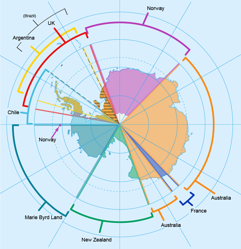
‘The International Geophysical Year (IGY) of 1957-58 aimed to end Cold War divisions among the scientific community by promoting global scientific exchange. The IGY prompted an intense period of scientific research in the Antarctic. Many countries conducted their first Antarctic explorations and constructed the first research stations on Antarctica. More than 50 Antarctic stations were established for the IGY by just 12 countries: Argentina, Australia, Belgium, Chile, France, Japan, New Zealand, Norway, South Africa, the Soviet Union [now Russia], the United Kingdom, and the United States [additional nations which have facilities within the original seven nation’s territorial claims include, China, India, Italy, Pakistan and Ukraine].
In 1959, these countries signed the Antarctic Treaty, which established that: the region south of 60°S latitude remain politically neutral; no nation or group of people can claim any part of the Antarctic as territory; countries cannot use the region for [mining], military purposes or to dispose of radioactive waste; and research can only be done for peaceful purposes. The Antarctic Treaty does support territorial claims made before 1959, by [the seven nations comprising] New Zealand [1923 Ross Dependency], Australia [1933 Australian Antarctic Territory], France [1840 Adelie Land], Norway [1931 Peter I Island, 1939 Queen Maud Land, 2015 Unclaimed Territory], the United Kingdom [1908 British Antarctic Territory], Chile [1940 Chilean Antarctic Territory], and Argentina [1943 Argentine Antarctica].
Under the treaty, the size of these claims cannot be changed and new claims cannot be made. Most importantly, the treaty establishes that any treaty-state has free access to the whole region. As such, research stations supported by a variety of treaty-states have been constructed within each of these territorial claims. Today, 47 states have signed the Antarctic Treaty.
The Antarctic also includes island territories within the Antarctic Convergence. The islands of the Antarctic region are: Orkney Islands and Shetland Islands, claimed by the United Kingdom; South Georgia and the South Sandwich Islands, administered by the United Kingdom and claimed by Argentina; Peter I Island and Bouvet Island, claimed by Norway; Heard and McDonald islands, claimed by Australia; and Scott Island and the Balleny Islands, claimed by New Zealand.
The Antarctic Treaty was an important geopolitical milestone because it was the first arms control agreement established during the Cold War. Many important documents have been added to the Antarctic Treaty. Collectively known as the Antarctic Treaty System, they cover such topics as pollution, conservation of animals and other marine life, and protection of natural resources. The yearly Antarctic Treaty Consultative Meeting (ATCM) is a forum for the Antarctic Treaty System and its administration. Only 28 of the 47 treaty-states have decision-making powers during these meetings. These include the 12 original signatories of the Antarctic Treaty, along with 16 other countries that have conducted substantial and consistent scientific research there.’
A subsequent treaty, the Madrid Protocol adopted in 1991, prohibited mining, required environmental impact assessments for new activities and ‘designated the continent as a natural reserve’. The Argentine and Chilean claims overlap with the British and have caused friction. Britain passed some of its claims to Australia and New Zealand after they achieved independence.
Encyclopaedia Britannica:
‘From the late 18th to the mid-20th century, whalers and sealers plied the rich seas that surround the continent. Science then replaced whaling and sealing as the primary year-round human activity in Antarctica. In addition, krill harvesting and other types of commercial fishing in the Southern Ocean expanded from the 1960s onwards. The new millennium saw tourism and (to a lesser extent) biological prospecting (the search for useful chemical compounds and genes in local species) become established sectors of the Antarctic economic landscape’ – Article: The Great Reset & the Fourth Industrial Revolution.
Organised commercial tourism in Antartica began in the mid-1960s and has grown substantially since 2000 with approximately 40,000 visitors coming to the region in 2010. The ATCM held meetings in New Zealand in 2009, discussing the impact of tourism on the Antarctic environment. The aim was to establish better practices which would reduce the carbon footprint and environmental impact of tour ships. Regulations and restrictions include: ‘numbers of people ashore; planned activities; wildlife watching; pre-[visit] and post-visit activity reporting; passenger, crew, and staff briefings; and emergency medical-evacuation plans. The ACTM recommended that treaty-states develop energy-efficient practices… and cut fossil fuel use from research stations, vessels, ground transportation, and aircraft. The Antarctic has become a symbol of climate change’ – Article: Climate Change & Global Warming: Looming Crisis or a New Equilibrium?
Antartica’s name means: “opposite to the Artic” and derives from Middle French, antarctique and the Latin, antarcticus meaning “opposite to the north.”
Online Encyclopaedia:
‘The Greek philosopher Aristotle wrote in Meteorology about an “Antarctic region” in c. 350 BCE. The Greek geographer Marinus of Tyre reportedly used the name in his world map from the second century CE, now lost. The Roman authors Gaius Julius Hyginus and Apuleius used for the South Pole the romanised Greek name polus antarcticus, from which derived the Old French pole antartike (modern pôle antarctique) attested in 1270, and from there the Middle English pol antartik, found first in a treatise written by the English author Geoffrey Chaucer. Belief by Europeans in the existence of a Terra Australis – a vast continent in the far south of the globe to balance the northern lands of Europe, Asia, and North Africa – had existed as an intellectual concept since classical antiquity. The belief in such a land lasted until the European discovery of Australia.
During the early 19th century, explorer Matthew Flinders doubted the existence of a detached continent south of Australia (then called New Holland) and thus advocated for the “Terra Australis” name to be used for Australia instead. In 1824, the colonial authorities in Sydney officially renamed the continent of New Holland to Australia, leaving the term “Terra Australis” unavailable as a reference to Antarctica. Over the following decades, geographers used phrases such as “the Antarctic Continent”. They searched for a more poetic replacement, suggesting names such as Ultima and Antipodea. Antarctica was adopted in the 1890s, with the first use of the name being attributed to the Scottish cartographer John George Bartholomew.’

A speculative representation of Antarctica labelled as ‘Terra Australis Incognita’ on Jan Janssonius’s Zeekaart van het Zuidpoolgebied (1657), Het Scheepvaartmuseum
The Encyclopaedia Britannica has some interesting comments regarding Antarctica and while not concurring with the elongated orthodox time frames presented (refer Appendix IV: An Unconventional Chronology); this writer is curious about the processes of Antartica’s evolution to its current formation. They state that Antartica was free of ice during most of its geologic history and that ‘there is no reason to believe it will not become so again.’
Britannica – emphasis & bold mine:
‘The geologic evolution of Antarctica has followed a course similar to that of the other southern continents. The earliest chapters in Antarctica’s rather fragmentary record extend far back, perhaps as much as 3 billion[?] years… Antarctica became isolated with the opening of the Drake Passage between the continent and South America… when land mammals diversified and flourished elsewhere, populating all the other continents of the world. Antarctica had long been thought to be a migratory path for marsupials moving between southern continents… But documentation for the theory was not discovered until 1982, when the first mammal remains, a marsupial fossil, were found on Seymour Island in the Weddell Sea.
Now bathed by polar ice, Antarctica has abundant fossil evidence that its climate and terrain at one time supported far more populous flora and fauna than today’s few seedless plants and primitive insects. Much of Antarctica was densely forested… dominated by southern conifers of podocarps and araucarias, with undergrowth of rainforest-type ferns. Angiosperm trees, particularly the southern beech, Nothofagus, appeared… According to some scientists, the discovery of Nothofagus pollen in the Transantartic Mountains… suggests that Nothofagus may have lingered as Antarctica drifted poleward, cooled, and became glaciated.
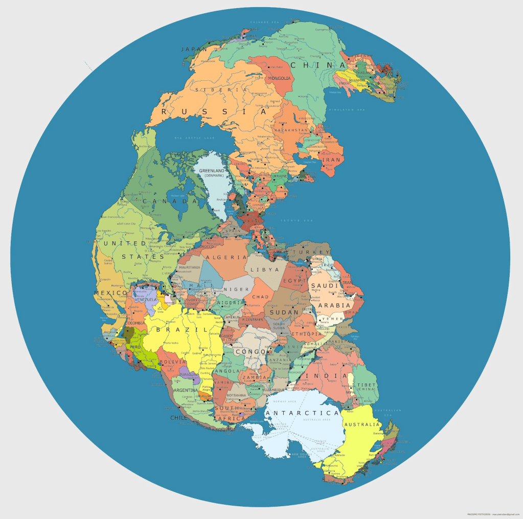
Remains of luxuriant extinct floras – as well as fossils of… reptiles, dinosaurs and amphibians – have been discovered, and these compare so closely to those of other southern continents that many geologists have postulated former contiguity of these lands in a single giant continent called Gondwana’ – refer Chapter XXII Alpha & Omega.
Britannica: ‘Modern theory ties mobile zones to the interaction and jostling of immense crustal [tectonic] plates… Modern plate boundaries may be far different from ancient ones presumably marked by old fold belts. Ancient Antarctic mobile belts, such as are followed by today’s Transantarctic Mountains, terminate at continental margins abruptly, as if sliced off, and seemingly reappear in other lands across young ocean basins.
Much research has been concentrated on attempting to match intercontinentally the detailed structure of opposed coasts, such as between Antarctica and Australia, in an effort to learn whether they had been actually connected before the latest cycle of crustal spreading from intervening mid-oceanic ridges. Similarities between ancient mobile belts now suggest to some geologists that Antarctica may even have been connected to southwestern North America… Antarctica provides the best available picture of the probable appearance 20,000 years ago of northern North America under the great Laurentide Ice Sheet.
Most of the Antarctic geologic record lies hidden beneath the vast regions of snow and ice that make up more than 95 percent of the continent’s surface terrain. No one knows what important segments of the record lie concealed in buried ranges such as the Gamburtsev Mountains, the topography of which has been mapped only by seismic reflections through the great East Antarctic Ice Sheet. The extraordinarily thick cover, the extremely difficult working conditions, and the tremendous expense of mounting expeditions into remote areas have long held geologic knowledge of Antarctica far behind that of other continents.
From results mainly of British expeditions early in the 20th century, the concept arose that Antarctica is made up of two structural provinces – a long, stable Precambrian shield in East Antarctica and a much younger Mesozoic and Cenozoic mobile belt in West Antarctica – separated by the fault-block belt, or horst, of the Transantarctic Mountains. East and West Antarctica have come to be known respectively as the Gondwana and Andean provinces, indicating general affinities of each sector with other regions; that is, the east seems to have affinity with the Gondwana region of peninsular India, and the west seems to represent a southerly continuation of the South American Andes. As new expeditions study and restudy each range in ever-increasing detail, concepts of the geologic structure are continually modified. Antarctica’s structural record is now known to be more complex than that implied in the past.
The average thickness of the terrestrial crust for both East and West Antarctica approximates that of other continents. Although it has been postulated that West Antarctica might be an oceanic island archipelago if the ice were to melt, its crustal thickness of about 20 miles indicates an absence of oceanic structure. This thickness is similar to that of coastal parts of other continents… Antarctica [is] the most seismically quiet of all continents, in which mostly minor activity is associated with surrounding oceanic ridges or volcanoes. However, the occurrence of one unusually large earthquake of magnitude 6.4 in the Bellingshausen Sea (an extension of the Southern Ocean that borders the western side of the Antarctic Peninsula) in 1977 suggests that the Antarctic Plate may have greater seismicity than generally believed. The ancient crust of Antarctica must have been highly mobile and the configuration of the continent many… years ago… far different from today’s.’
‘Tillites – rocks deposited by ancient glaciers – underlie Permian coal beds in numerous places in Antarctica just as they do in the other southern, including now tropical, continents. The widespread occurrence of glacial erratics, containing microfossils of Cretaceous and Cenozoic age, is an indication of the presence of rocks that are younger than the Beacon Sandstone lying underneath ice sheets near the Transantarctic Mountains.’
There are many ice-scarred volcanoes on Antartica, with ‘principal activity… concentrated in the volcanic Scotia Arc. Only one volcano, Gaussberg (90° E), occurs along the entire coast of East Antarctica. Long dormant, Mount Erebus, on Ross Island showed increased activity from the mid-1970s. Lava lakes have occasionally filled, but not overspilled, its crater, but the volcano’s activity has been closely monitored because Antarctica’s largest station (McMurdo Station, U.S.) lies on its lower flank. One of several violent eruptions of Deception Island, a volcanic caldera, in 1967-70 destroyed nearby British and Chilean stations.
Whereas volcanoes of the Antarctic Peninsula and Scotia Arc are mineralogically similar to the volcanoes typical of the Pacific Ocean rim, the others in Antarctica are chemically like those of volcanoes along the East African Rift Valley’ – refer Chapter XII Canaan & Africa.
Causal factors leading to the birth and development of [Antartica’s] continental ice sheets and then to their decay and death are… still poorly understood. The factors are complexly interrelated. Moreover, once developed, ice sheets tend to form independent climatic patterns and thus to be self-perpetuating and eventually perhaps even self-destructing’ – refer article: Climate Change & Global Warming: Looming Crisis or a New Equilibrium?
‘Cold air masses draining off Antarctic lands, for example, cool and freeze surrounding oceans in winter to form an ice pack, which reduces solar energy input by increasing reflectivity and makes interior continental regions even more remote from sources of open oceanic heat and moisture. The East Antarctic Ice Sheet has grown to such great elevation and extent that little atmospheric moisture now nourishes its central part.
The West Antarctic Ice Sheet (WAIS) has been the subject of much recent research because it may be unstable’ – Chapter I Noah Antecessor Nulla. ‘The Ross Ice Shelf is largely fed by huge ice streams descending from the WAIS along the Siple Coast. These ice streams have shown major changes – acceleration, deceleration, thickening, and thinning – in the last century or so. These alterations have affected the grounding line, where grounded glaciers lift off their beds to form ice shelves or floating glacier tongues. Changes to the grounding line may eventually transform the WAIS proper, potentially leading to removal of this ice sheet and causing a major rise in global sea level. Although the possibility of all this happening in the next 100 years is remote, major modifications in the WAIS in the 21st century are not impossible and could have worldwide effects.
Thousands of meteorites have been discovered on “blue ice” areas of the ice sheets. Only five fragments had been found by 1969, but since then more than 9,800 have been recovered, mainly by Japanese and American scientists. Most specimens appear to have landed on Antarctic ice sheets between about 700,000 and 10,000 years ago. They were carried to blue ice areas near mountains where the ancient ice ablated and meteorites became concentrated on the surface. Most meteorites are believed to be from asteroids and a few from comets, but some are now known to be of lunar origin. Other meteorites of a rare class called shergotties had a similar origin from Mars’ – refer Chapter XXII Alpha & Omega; and article: The Younger Dryas Stadial: End of the Earth… Beginning of the World.

An Antarctic meteorite, Allan Hills 84001 on display at the Smithsonian Museum of Natural History
Deposits of ‘coal, hydrocarbons, iron ore, platinum, copper, chromium, nickel, gold’ and other minerals have been discovered in Antarctica, though not in large enough quantities to extract.
The point raised about Antartica becoming free of ice again is fascinating and begs the question: how soon could this occur? The next three hundred years, two hundred years or even the next one hundred years? – Article: Climate Change & Global Warming: Looming Crisis or a New Equilibrium? If there is concern over the West Antartica Ice Sheet undergoing significant changes in the next one hundred years, it gives pause for thought. Apart from serious problems associated with rising sea levels, what might one find if layers of ice disappear from Antartica’s surface?
The admission of Antartica having drifted southwards towards the pole from a northerly position is enlightening as is the possibility that Antartica may not have been joined with South America or India, originally but rather with North America. Yet alternatively is the idea Antarctic volcanoes share commonality with those of East Africa and the Pacific Rim (Australia), showing perhaps volcanic formation on Antarctica occurred more recently in its history, after the island continent had repositioned further south. These factors support the claim that Antarctica’s ‘configuration’ was different when located further north.
The element of a ‘highly mobile ancient crust’ testifies to a disaster of some kind which impacted Antartica and resulted in a more rapid continental drift; particularly as it is an island. Likewise, realising that Antarctica’s structural record is more ‘complex’ than first thought and the formation and activity of Antartica’s ice sheets being ‘still poorly understood’ – reflects an unusual past.
While scientists have given themselves a very big time window to account for meteorite specimens having landed on Antarctica’s ice sheets ‘between about 700,000 and 10,000 years ago’; it is proposed that ten thousand years ago is the more accurate date. We will study this matter further, for this time frame is of interest for a number of reasons – Chapter XXII Alpha & Omega; and Appendix IV An Unconventional Chronology. As is the fact that meteorite samples include those originating from both the Moon and Mars – Article: The Younger Dryas Stadial: End of the Earth… Beginning of the World.
There is an intriguing map dating from 1513, by the Ottoman-Turkish Admiral and Cartographer, Ahmed Muhiddin Piri, known as the Piri Reis map – shown below. Only the western third of the map has been preserved, which shows the Atlantic coasts from France and the Caribbean on the north to what looks to be Antarctica, or Queen Maud Land on the south. The inference that any part of Antarctica could have been mapped prior to 1513 is astonishing.
Intensive studies led Charles Hapgood (1904-1982), an American College Professor to consider this and other late medieval maps to have derived from prototypes drawn in pre-Hellenic times and perhaps incredibly, as early as from the last Ice Age. According to John K Wright, these ‘older maps were based upon a sophisticated understanding of the spherical trigonometry of map projections, and… upon a detailed and accurate knowledge of the latitudes and longitudes of coastal features throughout a large part of the world.’ Charles Hapgood in his book, Maps of the Ancient Sea Kings, presents his belief that these maps provide ‘evidence of advanced civilisation in the Ice Age.’

The Piri Reis map with north on the left and south on the right. Thus Europe and Africa are shown on the top of the frame and the Americas on the bottom.
What is even more compelling about the Piri Reis map is that it apparently shows Antartica’s coastline ice free and the continent without its ice cap, which was only visible about six thousand years ago. When the Piri Reis map was rediscovered in 1929, ‘the remaining fragment – drawn on gazelle-skin parchment approximately 87 cm × 63 cm – garnered international attention as it [included] a partial copy of an otherwise lost map by Christopher Columbus.’

Translation of the Piri Reis Map
Hapgood discovered that the Piri Reis map had been created using the Mercator Projection, a method of creating maps which allows for a more accurate curvature when transferring maps from paper to a globe. Yet, European cartographers had not utilised this technique until 1569. The map seemed to defy the laws of time.
According to Dr Pat Hanratty, Hapgood wrote ‘to the United States Air Force, [and] asked if there was any correlation between various geographical details on the Piri Reis Map and results of seismic findings conducted by the Swedish-British-Antarctic Expedition of 1949. The report showed there was high correlation between Antarctica under the ice with large portions of the map. In fact, it corresponded with fifty-five specific geographical locations on the continent.’
Captain Lorenzo W Burroughs, a United States Air Force captain with a background in cartography, claimed that the depiction of Antarctica was in fact an accurate representation of what the continent had looked like before it was covered in ice. “The Princess Martha Coast of Queen Maud Land, Antarctica, appears to be truly represented on the southern sector of the Piri Reis map… [and] places beyond a reasonable doubt the conclusion that the original source maps must have been made before the present Antarctic ice cap covered the Queen Maud Land coasts”, he wrote in a letter to Hapgood.
Of interest is not just that the Piri Reis map shows Antartica ice free, but that the continent is connected to South America. Dr Hapgood claimed coastlines were exaggerated in size in the past in order to make details clearer to see and so coastal accuracies were then overlooked, resulting in continents seemingly being connected.
Paranormal researchers advocated extraterrestrial assistance, while others hypothesised the possible involvement of a civilisation based around the ‘Lost City of Atlantis.’ Though not everyone accepted Hapgood’s conclusions which were inspired by Captain Arlington H Mallery, author of Lost America, a civil engineer and amateur archaeologist who used a grid system to reposition the coordinates on old maps and claimed the accuracy of the reconstructed maps to be comparable to modern ones. Hanratty states: ‘… ancient maps were frequently accurate to within one half-degree of longitude – something Europeans didn’t achieve until the invention of the marine chronometer in the eighteenth century.’
First, there are a number of notable differences in the sizes of various coastlines on Reis’s map compared with modern maps, with some areas missing entirely. Hapgood merely attributed this to copying errors made by Reis and ‘took it upon himself to insert some of the ‘missing’ sections based on the source maps Reis had used.’ But after ‘filling in some of the empty areas and altering landmasses… Hapgood found that the map now had five separate equators.’
A further issue is that Antarctica on Reis’s map barely resembles the real continent. Though it is possible that over time the Antarctica landmass has altered.

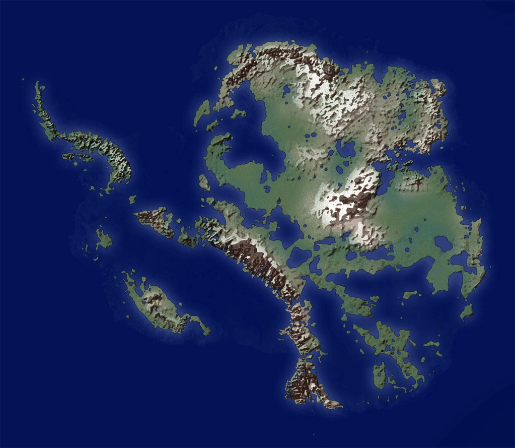
2001 image of the bedrock topography of Antarctica
What if the map does not represent Antartica at all? A possible explanation is in Reis’s sources. According to Joe Turner: ‘Classical Greek cartographers originally proposed the existence of a southern continent due to the belief that landmasses must be ‘balanced’ at either end. Therefore, one must exist in the southern hemisphere to balance the ones in the northern hemisphere. Due to this incorrect belief, many sixteenth-century cartographers included an invented landmass in the southern hemisphere, despite having any proof of the existence of one. As Reis used at least eight Greek maps and charts to draw up his own map, this was one possible solution.’
For example, the 1570 rudimentary map by Ortelius below, which shows the yet confirmed link between the proposed continent of Antarctica and South America. Note also the imagined landmasses surrounding the North Pole.

Plausibly, the theory that many believed to be an ice free depiction of Antarctica ‘is actually nothing more than the South American coastline. Some researchers hypothesized that Piri Reis simply ran out of room to draw on the gazelle skin. So he crammed as much of South America in as he could. Interestingly, Reis’s notes’ supports this theory. For Reis states this region is ‘very hot’ and ‘full of snakes’. ‘While these descriptions certainly wouldn’t fit in with what they knew about Antarctica at the time, it could very well describe the Amazon Jungle.’
Either the Piri Reis map depicts an ice free Antarctica of the distant past, inspired by an unknown or unrecognised advanced civilisation; or Charles Hapgood let his imagination lead him to misinterpreting a map, which simply shows either an imagined southern landmass or the South American coastline. Even if Hapgood was wrong, the fact Antartica was once ice free remains incontestable. Nor is its link with Atlantis necessarily negated. What is perhaps open to question is how tangible a rapid and recent pole shift is in relationship to Antartica’s drift southwards, as put forward by Hapgood.
Even considering these counter arguments, the support for Hapgood’s conclusions remain convincing. Dr Hanratty continues: ‘In 1959, while studying maps in the Library of Congress, Hapgood sat transfixed: “As my eyes fell upon the southern hemisphere of a world map drawn by Oronteus Finaeus in 1531, I had the instant conviction that I had found here a truly authentic map of the real Antarctica”.’

‘The mountain ranges shown were individualized, some being on the coast and others inland. The map showed rivers flowing into the sea, suggesting the coasts may have been ice free when the original map was drawn. The most interesting thing was that once Hapgood corrected the map for scale, he concluded that the size of the Antarctic Continent on the map of Oronteus Finaeus was correct by modern findings. Furthermore, the Hapgood team identified 50 geographical points on the Finaeus map, as re-projected, whose latitudes and longitudes were located quite accurately… some of them quite close to the pole…’
An enlightening article by Rand and Rose Flem-Ath in 2015, includes details of Mallery’s findings, as well as their communication with Charles Hapgood on the subject.
‘An amateur scientist by the name of Captain Arlington Mallery made it his mission to determine the age of the source maps used by Piri Reis. So radical were Mallery’s conclusions that he hesitated to reveal them. In August 1956, he finally decided to reveal his findings on a radio show sponsored by Georgetown University. He explained that in June 1954 he was working in the map room of the Library of Congress when his friend “… the Chief Engineer of the Hydrographic Office handed me a copy of a map which had been sent to him by a Turkish naval officer.
He suggested that I examine it in the light of the information we already had on the ancient maps. After making an analysis of it, I took it back to him and requested that the Officer check both the latitude and longitude and the projection. When they asked why, I said, ‘There is something in this map that no one is going to believe coming from me, and I don’t know whether they will believe it coming from you.’ That was the fact that Columbus had with him a map that showed accurately the Palmer Peninsula in the Antarctic continent.”
Mr. Warren, the host of the radio show, interviewed Mallery and M.I. Walters of the U.S. Navy Hydrographic Office:
HOST: You say that these maps have been checked by the Hydrographic Office of the U.S. Navy?
WALTERS: Yes.
HOST: As far as you are concerned, are they accurate?
WALTERS: Yes, they are.
HOST: How old are the maps?
WALTERS: These maps go back 5,000 years and even earlier. But they contain data that go back many thousands of years previous to that.
Walters remarked on the comparisons between the Piri Reis Map and the newly (1954) discovered sub-glacial features of the Queen Maud region of Antarctica: “We have taken the old charts and the new charts that the Hydrographic Office produces today and made comparisons of the soundings of salient peaks and mountains. We have found them to be in astounding agreement. In this way, we have checked the old work very closely. We put very much confidence in what Captain Mallery has disclosed.
HOST: Mr. Mallery, this must then lead to the conclusion that there were competent explorers and map makers along the coast of the Atlantic long before Columbus.
MALLERY: Several thousand years before. Not only explorers, but they must also have had a very competent and far-flung hydrographic organization, because you cannot map as large a continent as Antarctica as we know they did – probably 5,000 years ago.
It can’t be done by any single individual or small group of explorers. It means an aggregation of skilled scientists who are familiar with astronomy as well as the methods required for topographic surveying.’
One of Charles Hapgood’s students told him about the radio broadcast. The Professor was immediately fascinated and decided to: “…investigate the map as thoroughly as I could…”
Since Mallery had used the US Navy for his investigations Hapgood decided to get a second opinion from the Cartographic staff of the Strategic Air Command (SAC). The U.S. Air Force investigation came to the same conclusions as the US Navy. They determined that the southern part of the map did in fact depict portions of sub-glacial Antarctica.
USAF Lt. Colonel Harold Z. Ohlmeyer wrote to Hapgood on the 6th of July 1960.
Dear Professor Hapgood,
Your request for evaluating certain unusual features of the Piri Reis World Map of 1513 by this organization has been reviewed. The claim that the lower part of the map portrays the Princess Martha coast of Queen Maud Land, Antarctica, and the Palmer Peninsula is reasonable. We find this the most logical and in all probability the correct interpretation of the map. The geographic detail shown in the lower part of the map agrees very remarkably with the results of the seismic profile made across the top of the ice cap by the Swedish-British-Norwegian Expedition of 1949. This indicates the coast line had been mapped before it was covered by the ice cap. The ice cap in this region is now about a mile thick. We have no idea how the data on this map can be reconciled with the supposed state of geographic knowledge in 1513.
(signed)
HAROLD Z. OHLMEYER
Lt. Colonel, USAF
Commander
‘Our adventure with the study of ancient maps began in the summer of 1977 when Charles Hapgood replied to an article we wrote outlining our belief that Antarctica was once the site of Atlantis. We’d concluded that Hapgood’s theory of earth crust displacement was the missing link that could unravel the mystery of the lost island continent. Charles replied:
August 3rd, 1977
Dear Rose and Rand,
I am astonished and delighted by your article which arrived here today. Believe it or not, it is the first truly scientific exploration of my work that has ever been done. You have found evidence for crust displacement that I did not find.
However, it would seem that you are not aware of a book I published in 1966 entitled Maps of the Ancient Sea Kings. Since you are considering presenting your article to the Royal Geographical Society (of which I was a member until I stopped paying my dues), you should examine this book, and I am mailing a copy of it to you.
What I found, after long research, was that many maps considered of medieval or Renaissance origin are in fact copies of copies of maps drawn in very remote antiquity, and among them is one showing a deglacial Antarctica. I was able to solve the projections of these maps with the help of a mathematician, and have them confirmed by the Cartographic staff of the Strategic Air Command at Westover Air Force Base in Massachusetts. …

‘A week later a copy of Maps of the Ancient Sea Kings arrived. Far from dampening our enthusiasm for the idea that Atlantis may have once been Antarctica, the book had the opposite effect. We concluded that the ancient maps of sub-glacial Antarctica provided stunning evidence in support of our theory. After the publication of the first edition of When the Sky Fell in January 1995, we returned to the Piri Reis map to determine if there were grounds to support Mallery and Hapgood’s claim that the source maps used in the construction of the Piri Reis map were hundreds of years older than the 1513 date of its construction. One of the oddities about the Piri Reis map was that it had been drawn using an extremely sophisticated projection. An “equidistant projection” depicts the features of the earth from a single point on its surface. This projection can be calculated from any spot on the globe.
Perhaps the most familiar equidistant projection is the blue and white flag of the United Nations, centered on the North Pole.’

‘The equidistant projection was one that was very familiar to the cartographic staff of the Strategic Air Command at Westover Air Force Base in Massachusetts. It was used to target Soviet military and economic assets. For example, a map drawn using Moscow as its center allowed the military to calculate the quickest delivery time for a missile to travel from any NATO base to the Soviet capital. The closest NATO missile base to Moscow was in Turkey. In November 1962 when Soviet missiles were introduced to Cuba, an equidistant projection map centered on Castro’s island revealed in stark detail how much United States territory could be targeted. The “Cuban Missile Crisis” was only resolved when JFK (secretly) proposed a delayed withdraw of NATO missiles from Turkey in exchange for Khrushchev’s removal of the USSR missiles in Cuba.
Hapgood and his students (notably Frank Ryan) spent months trying to determine the exact center of the Piri Reis Map. At first, Hapgood was convinced that it was the city of Syene where Eratosthenes, the librarian and father of geography, had made his famous calculations about the size of the earth. Hapgood submitted this suggestion to the cartographic crew at Westover Air Force Base. Captain Burroughs concurred. He wrote: “…Piri Reis’ use of the portolano projection (centered on Syene, Egypt) was an excellent choice…” Charles Hapgood explained to Arch C. Gerlach (Chief of the Map Division at the Library of Congress) that the Piri Reis map: “… required more astronomy than was known in the Renaissance. The mathematics require that whoever constructed it had to know the linear distance from Syene to the North Pole to within a degree of accuracy. Piri Reis did not know that, neither did Columbus…”
We see below how the complete map must have looked based on the same projection used by Piri Reis in 1513. The chart Christopher Columbus carried on his voyage would have resembled this projection.’

The 1513 Piri Reis projection is just a fragment of the secret map that Columbus may have possessed. If the lost map is ever found it should depict the entire globe using an equidistance projection centered on the ancient Egyptian city of Syene. Despite the fact that professionals had verified Syene as the center of the map, Hapgood remained skeptical. He thought that the ancients would have been more likely to use the Tropic of Cancer which divides the tropical from the temperate climatic zones.
Hapgood was certain that such an important global marker would have been highly significant to the ancient navigators. Today, the Tropic of Cancer lies near Syene but not precisely over it. The difference in distance is small but Hapgood and his students wanted to be exact in their calculations. There was considerable debate whether or not to use the measurement from the ancient city or from the climatic marker. Hapgood mistakenly assumed that it had to be an either/or choice between Syene and the ‘Tropic of Cancer. It was a false choice because there was a time when the Tropic of Cancer lay directly over Syene. The clue to that synchronicity of time and place lies within the very projection of the Piri Reis Map. But first a critical question must be answered. When did the Tropic of Cancer and Syene last share the same latitude?’

The Tropic of Cancer
‘Astronomers have concluded that it takes a century for the Tropic of Cancer to drift 40 seconds off latitude. This gives us a formula for our calculations and enables us to bulls-eye the date when the original mapmakers were at work. Syene is 38 minutes and 30 seconds from today’s Tropic of Cancer. This is 2280 (38 x 60 to convert minutes to seconds) plus the 30 seconds give us a total of 2310 seconds difference. We then divide these seconds by 40 to find that the Syene was last on the Tropic of Cancer some 57.75 centuries ago. By calculating the difference in distance from the latitude of today’s Tropic of Cancer (23:27N) to that of Syene (24:05:30N) we discover the answer about 5775 years ago – that is, circa 3760 BC. It’s noteworthy that the Jewish calendar begins on this date.
The projection of the Piri Reis points like an arrow at a pivotal turning point in human history. Archaeology teaches that Egyptian civilization dawned circa 3800 BC. Can it really be mere coincidence that the Piri Reis Map looks to date from the dawn of Egyptian civilization? Far more likely that the sophisticated source maps used by Piri Reis are remnants passed on by the survivors of a lost Ice Age civilization – a seafaring civilization that had mapped the world (including parts of Antarctica’s coastline when it was ice-free)…’
According to an unconventional chronology, this period coincides with the Age of Taurus the Bull, lasting from 4490 to 2330 BCE, as well as the transitional period between the Dwapara Yuga and the Kali Yuga from 3976 to 3676 BCE. This period was ‘marked by a series of environmental cataclysms… [and] is referred to in geology as the 5.9 kiloyear event… it is considered one of the most intense aridification events during the Holocene period.
It occurred around 3900 BC, ending the Neolithic Subpluvial and initiated the most recent desiccation of the Sahara desert. At the same time, between 4000 BC – 3500 BC, the coastal plains of Sumer experienced severe flooding, which “was the local effect of a worldwide episode of rapid, relatively short-term flooding known as the Flandrian transgression – which had a significant impact not only along the shores of the Gulf but in many other parts of Asia as well.” This catastrophic flooding event led to the end of the Ubaid period in Mesopotamia, and triggered a worldwide migration to river valleys. This transitional period between the Yugas is recorded in many ancient calendars, as we find a clustering of important dates around this epoch.’
Other maps have been discovered depicting the Earth prior to the last ice age. One such map discussed by Ancient Code, April 20, 2022, ‘is the controversial cartographic chart created by a French geographer by the name of Philippe Buache de la Neuville.’

Ancient Code:
‘Many people claim that the Bouche Map… accurately positioned the Canary [Islands]. The map issued in 1737 [date of publication on map: September 3, 1739] also displays the correct outline of the underwater plateau on which the islands are located. This means that the source of the map used to create it is based on a survey of the shape before glaciers melted and ocean levels rose. Even more interesting is the fact that the Buache Map depicts the waterway which divides the continent of Antarctica into two landmasses. If we observe the map carefully, we will find that two important words are written on the map: conjecturée (conjectured) and soupçonnée (suspected) are located in the regions depicting the southern continent. This indicates, according to some, that the landmass was not seen on older maps, but that the continent was hypothesized by Buache himself.’
In support of this is that the Buache map has two versions. One of the charts is believed to accurately depict the ice free coastline of Antarctica before it was buried by thick layers of ice; ‘while the other chart makes no mention of the continent whatsoever.’
The latter map is said to be more common and is considered to have been an earlier version of Buache’s hypothesis, while the former is thought to incorporate Buache’s later thoughts on Antartica. Alternatively, it is suggested that the Buache Map with Antarctica included may have been issued fraudulently by another cartographer, or even be a more recent outright forgery.
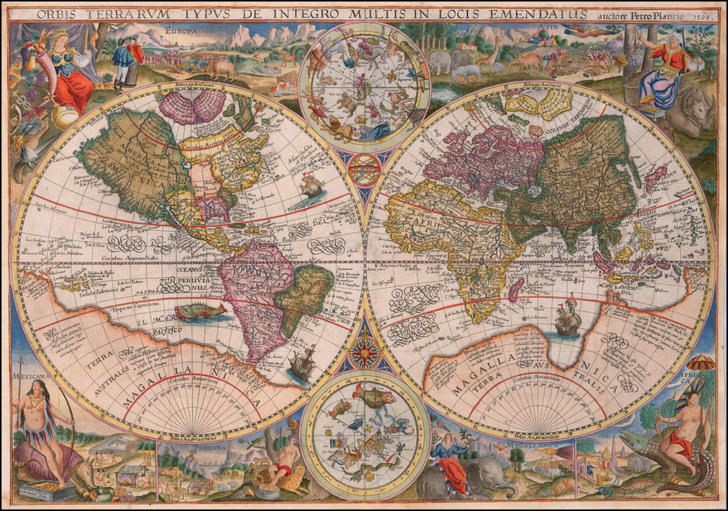
Terra Australis, or the Southern Land, is depicted on Petrus Plancius’s Orbis Terrarum of 1594 as a massive continent, spanning much of the southern hemisphere. Places discovered but little understood are depicted as the Northern edge of Terra Australis, including Tierra del Fuego south of the Americas and New Guinea.
Before we investigate an Antartica link with Atlantis, the various locations theorised for Atlantis are worth noting. The story begins so-to-speak with Greek philosopher Plato (424-348 BCE) and his dialogues Timaeus and Critias. In the former written in 360 BCE, Plato describes Egyptian priests in conversation with the Athenian lawgiver Solon (circa 630-560 BCE) describing Atlantis as an ‘island continent’ larger than Asia Minor and Libya combined and situated beyond the Pillars of Hercules – the Strait of Gibraltar.
About 9,000 years before the birth of Solon… Atlantis was a rich island city-state whose powerful princes allegedly conquered many of the lands of the Mediterranean until they were finally defeated by the Athenians and their allies. The Atlantians had become ‘wicked and impious’ and as result Atlantis was swallowed up by the sea after series of earthquakes. In the Critias, Plato provides a ‘history of the ideal commonwealth of the Atlantians.’
Due to the story originating from Egypt there are a number of locations in the mediterranean put forward, such as Helike, Thera, Santorini, Crete and Troy. Other proposed locations include: the island of Pharos, the Cyprus basin southeast of Cyprus, Israel, Sardinia, Malta, Turkey, the Black Sea, Andalusia and Morocco.
Outside of the Mediterranean, locations include the Azores Islands, Canary Islands, Madeira, Cape Verde, Northern Spain, Great Britain, Ireland, the Irish Sea, the North Sea, Denmark, Sweden, Finland, Bimini in the Bahamas, the Bermuda Triangle, far flung India, Indonesia and even the North Pole. As can be deduced, just about everywhere west of Egypt or Spain has been considered and subsequently refuted – particularly if it is not an island.

A map showing the supposed extent of the Atlantean Empire – from Ignatius L Donnelly’s Atlantis: the Antediluvian World, 1882
The North Pole is the first interesting suggestion, for it is ironically as far in distance opposite to Antarctica as one can choose and was touched upon in relation with Hyperborea – refer Chapter XXII Alpha & Omega. A proponent for this theory was William F Warren (1833-1929), a professor of systematic theology at Boston University. He wrote a book entitled Paradise Found: The Cradle of the Human Race at the North Pole in 1885. Where he promoted his theory, that the original centre of mankind once sat at the North Pole; placing Atlantis there, as well as the Garden of Eden, Mount Meru (centre of the physical, metaphysical and spiritual universes), Avalon and of course, Hyperborea. ‘Warren believed all these mythical lands were folk memories of a former inhabited far northern seat where man was originally created.’
The second interesting suggestion is that of the Americas, for the simple fact that until there is evidence from the discovery of a sunken island city-state in the Atlantic Ocean, America is quite a feasible and attractive option for Atlantis.
Encyclopaedia:
‘Until the discovery of the New World many scholars believed that Atlantis was either a metaphor for teaching philosophy, or just attributed the story to Plato without connecting the island with a real location. When Columbus returned from his voyage to the west historians began identifying the Americas with Atlantis. The first was Francisco Lopez de Gomara, who in 1552 thought that what Columbus had discovered was the Atlantic Island of Plato.
In 1556 Agustin de Zarate stated that the Americas was Atlantis which at one time began from the strait of Gibraltar and extended westwards to include North and South America and that it was as a result of Plato that the new continent was discovered. He also said it had all the attributes of the continent described by Plato yet at the same time mentioned that the ancient peoples crossed over by a route from the island of Atlantis.
This was also repeated and clarified by historian Pedro Sarmiento de Gamboa in 1572 in his “History of the Incas”, who by calculation of longitude stated that Atlantis must have stretched from within two leagues of the strait of Gibraltar westwards to include “all the rest of the land from the mouth of the Marañon (Amazon River) and Brazil to the South Sea, which is what they now call America.” He thought the sunken part to be now in the Atlantic Ocean but that it was from this sunken part that the original Indians had come to populate Peru via one continuous land mass. He says that South America was also known by the name of the Isla Atlanticus.
It first appeared as the Atlantic Island (Insula Atlantica) on a map of the New World by cartographer Sebastian Munster in 1540 and again on the map titled Atlantis Insula by Nicolas Sanson and son (1669) which identified both North and South America as “Atlantis Insula”, the eastern part of the Atlantic Ocean as “Oceanus Atlanticus” and the western part of the Atlantic Ocean plus the Pacific Ocean as “Atlanticum Pelagus”. This edition was further embellished with features from the Atlantis legend by his son Guillaume Sanson including the names of the ten kings of Atlantis with Atlas’ portion being in Mexico. Sanson’s map supposedly showed what the earth looked like 200,000 years before there were any humans on it. Francis Bacon [article: The Shakespeare Shadow] and Alexander von Humboldt also identified America with Atlantis; Janus Joannes Bircherod said in 1663 orbe novo non novo (“the New World is not new”).’
If it were not for the option of Antartica, then this writer would consider the Americas as a viable answer to the Atlantis mystery and not one to reject out of hand. Though for the purpose of this article, we will concentrate solely on Antartica as the missing Atlantis, for Plato records it was an island. As seen already, resistance to this being the solution for a mythical land mass is substantial. Yet, until a better explanation is provided, it cannot be summarily dismissed just because certain people supposedly lacking in academic credibility have jumped on its band wagon or associated the subject with aliens for example.

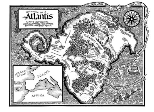
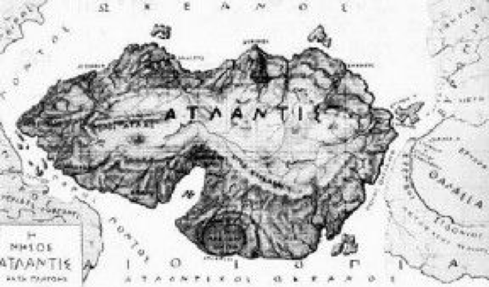
Above, is a depiction of Atlantis situated in the Atlantic Ocean, sandwiched between the continents of America, Africa and Europe. Notice the uncanny similarity of form, allowing for changes over time, with present day Antartica. The following two map drawings of Atlantis also square approximately with the geography of Antartica.
Encyclopaedia – emphasis mine:
‘The theory that Antartica was Atlantis was particularly fashionable during the 1960s and 1970s, spurred on partly both by the isolation of the continent, and also the Piri Reis map… Flavio Barbiero, Charles Berlitz, Erich Von Daniken and Peter Kolosimo are some of the popular authors who made this proposal. More recently Rose and Rand Flem-ath have proposed this in their book, When the Sky Fell; the theory was revised and made more specific in Rand’s work with author Colin Wilson, in The Atlantis Blueprint.
The second work theorized that Atlantis was to be found in Lesser Antarctica, near the coast of the Ross Ice Shelf. A geological theory known as “Earth Crust Displacement” forms the basis of their work. Charles Hapgood came up with the “Earth Crust Displacement” theory”. Hapgood’s theory suggests that Earth’s outer crust is able to move upon the upper mantle layer rapidly up to a distance of 2,000 miles, placing Atlantis in Antarctica, when considering the movements of the crust in the past. Albert Einstein was one of the few voices to answer Hapgood’s theory. Einstein [1879-1955] wrote a preface for Hapgood’s book Earth’s shifting crust, published in 1958.
This theory is particularly popular with Hollow Earthers, and can be seen as a mirror of the Hyperborean identification. In his book “Fingerprints of the Gods” author Graham Hancock argues for the Earth Crustal Displacement theory in general, and the Atlantis/Antarctica connection specifically, then goes on to propose archaeological exploration of Antarctica in search of Atlantis.’

We will turn our attention fully to Charles Hapgood’s studies and specifically regarding earth crust displacement. We will also investigate global cataclysms and particularly the work presented by Chan Thomas in his book: The Adam and Eve Story: The History of Cataclysms, 1993. First, a perusal of ideas written by leading exponents on the subject.
In When the Sky Fell, Rand and Rose Flem-Ath, explain how an earth crust displacement could happen again in the future, perhaps in connection with high solar activity – Article: Climate Change & Global Warming: Looming Crisis or a New Equilibrium? Their work contains scientific, genetic, and linguistic evidence in support of Antarctica as the location of the long lost island continent of Atlantis. The book also convincingly shows that Atlantis was not swallowed by the sea, but was actually entombed beneath miles of polar ice.
The Flem-Aths share their in-depth research, beginning in their introduction – emphasis mine:
‘The theory of earth crust displacement, which proposes that the earth’s outer shell catastrophically shifts over the planet’s subterranean layers, forms the scaffolding of our quest for the lost civilization of Atlantis… we detail our fresh research gleaned from three weeks of study at Hapgood’s long-neglected Yale archives. We delve in to his correspondence with President Dwight D. Eisenhower and visit the president’s archives in Abilene, Kansas.
These forgotten documents reveal how Christopher Columbus may have possessed a world map drawn by the survivors of Atlantis. Fragments of the map incorporate astronomical clues pointing to the date it was originally drafted, 3800 BCE, a date that coincides with the dawn of Egyptian civilization. We learn how Einstein urged that Hapgood be awarded a Guggenheim Foundation Grant because his earth crust displacement theory was “fascinating and important.”
The chronicle of Atlantis is properly called a legend, not a myth. A legend tells of events that took place in the real world at a specific time involving human beings. A myth, in contrast, is enacted on a supernatural stage where events are controlled by all-powerful gods and goddesses. Plato, the source of the Atlantis legend, tells us that the island continent perished at a specific time, some 11,600 years ago. He says that the vast island was located in a “real ocean” and was destroyed by earthquakes and floods of extraordinary violence. Gods don’t determine the unfolding events in this legend. Instead, it is the palpable forces of nature that prevail against Atlantis and end its rule. Atlantis is a legendary, but real, place that can be found.’
Investigative journalist Graham Hanock responded with a statement on November 22, 1999, following a BBC Horizon documentary on Atlantis. Aired as Atlantis Uncovered on October 28 and Atlantis Reborn on November 4, 1999. His comments regarding Atlantis and its link with Antartica having been misrepresented. As it is planned to write a specific and separate article about the cataclysm which led to the destruction of Atlantis (The Younger Dryas Stadial: End of the Earth… Beginning of the World), we will quote his comments only in relation to Atlantis and Antartica – capitalisation his.
‘One of the many gross misrepresentations of my work to appear in the recent BBC2 ‘Horizon’ documentary (‘Atlantis Reborn’, 4 November 1999) was the repetition of a most unfortunate error often made by other media as well since the publication of Fingerprints of the Gods in 1995. This is the error that I was somehow the originator or creator of the theory that identifies Antarctica with the lost continent of Atlantis.
I AM NOT THE ORIGINATOR OR CREATOR OF THIS THEORY. The full credit for it, as I explained in Chapters 50 and 51 of Fingerprints of the Gods, belongs to the Canadian authors Rand and Rose Flem-Ath who set it out in their book When The Sky Fell (1995) which I was privileged to read in manuscript form in 1993. I believed then, and believe still, that their theory is a ground-breaking one and that it is immensely important to any proper consideration of the possibility that there may have been a lost civilisation.
Nevertheless despite the fact that I made this clear at the outset, and have continued to make it clear at [every] opportunity thereafter when the Atlantis/Antarctica theory has been brought up, there have been numerous occasions in both the print and broadcast media when this theory has been wrongfully credited to me. These repeated errors have, I know, been a source of great distress for the Flem-Aths, which I very much regret. In the case of the recent ‘Horizon’ programme, however, the error was further compounded, through the use of extremely selective editing, to make it appear as though I have now withdrawn all support from the Atlantis/Antarctica theory. This is not correct.
… in Chapter 12 of my… book Heaven’s Mirror (1998)… I point out that: “The earth-crust displacement theory advocated by Hapgood, the Flem-Aths and others has not been well received by orthodox planetary scientists. Geologists in particular have poured scorn on the theory, linked it to the lunatic fringe, and failed to give it any serious peer-review. The impression has been successfully conveyed that it is simply an ‘impossible’ process, advocated by lunatics and therefore not worthy of consideration by genuine scientists. Yet behind the scenes the evidence has been slowly mounting up that displacements of the earth’s crust do occur from time to time and that there is no physical or geological reason why such a displacement should not have occurred around 12,000 years ago – precisely as the Flem-Aths allege.”
The Flem-aths provide further interesting comments on the Antartica-Atlantis connection in an article entitled, Atlantis in Antarctica? Tracking the Myths of a Lost Island Paradise, published in New Dawn, Special Issue 8, June 2009 – emphasis & bold mine.
‘The idea that Antarctica was home to Atlantis has at its root a radical rethinking of the geological history of our planet. Formulated by our mentor, Charles H. Hapgood the theory of an Earth crust displacement enjoyed the enthusiastic support of Albert Einstein. Hapgood and Einstein corresponded about Hapgood’s work for the last three years of the great physicist’s life.
The essence of the theory that piqued his interest lay within the physical dynamics of the Earth’s inner structure. The bulk of our planet’s mass consists of an inner core of solid iron surrounded by liquid iron. This core is encircled by the thickest part of the Earth which is composed of two mantles of solid rock. Covering the upper mantle lies the asthenosphere or “weak zone.” It is the asthenosphere’s mobility that allows the Earth’s crust (lithosphere) to shift.
An Earth crust displacement occurs when the entire outer shell of the planet moves leaving a devastating climatic legacy.
Because the Earth’s tilt (axis) is not affected, the planet’s climatic zones (polar, temperate and tropical) don’t change. However, vast areas of the crust (which includes ocean basins) do experience a catastrophic change in climate. Before the last Earth crust displacement, part of Antarctica lay outside the polar zone. This is the area that could have been the site of Atlantis.
The consequences of a crustal displacement are monumental. As the Earth’s crust ripples over its interior, the world is shaken by incredible earthquakes and floods. The sky seems to fall. The sun appears to rise and set over an altered horizon until finally the crust grinds to a halt. Beneath the ocean, earthquakes generate massive tidal waves that inundate coastlines. Some lands shift to warmer climates. Others, propelled into the polar zones, suffer the direst of winters. Melting ice caps, released from the polar areas, raise the ocean’s level ever higher. All living creatures must adapt, migrate or die.
In 2000, Rand and Colin Wilson published The Atlantis Blueprint, a book that explored the idea that over 60 of the world’s most sacred sites fit into a global pattern that suggests that they were positioned by a long lost, yet extremely advanced, civilisation. In 2001, the book appeared in the United States and Rand began a correspondence with Jared Freedman who suggested an answer to the mystery of the missing mechanism of Earth crust displacements. Jared is a computer professional and inventor who worked extensively with electromagnets. He was aware that the Earth is in effect a gigantic magnet surrounding a metal core. When magnets pass through an electromagnetic field heat is generated. Jared wrote:
“If the Earth’s magnetic field received such a tremendous distortion of its magnetic field, over a prolonged period of time, it would generate immense amounts of heat within the Earth’s core as the Earth spun through the force that was causing the magnetic field disruption. The only force that can collapse the Earth’s magnetic field is the Sun’s magnetic field.”
Jared noted that the Sun also experiences climatic variations but because of its immense size they happen over longer periods of time. Solar storms can theoretically last for “days, weeks or even more.” If the Earth passes through electromagnetic waves coming from the Sun then force would be applied steadily at one of the poles. That energy would be carried into the Earth’s core. Metal flowing to the Earth’s surface could transform the asthenosphere from a sluggish tar into a liquid. Jared wrote:
“Perhaps it is not the disruptions of the Earth‘s core that cause fluctuations in the Earth‘s magnetic field, but rather disruptions of the Earth‘s magnetic field cause fluctuations in the Earth‘s core.”
Einstein had doubted that the weight of the Earth’s ice sheets would be sufficient to dislodge the crust. He also doubted that an abrupt shift of the entire axis was the explanation because any force that could accomplish that would probably shatter the planet. What he sought was a steady force applied to the crust for a sustained period. Jared Freedman’s theory not only addresses all these problems but also provides a mechanism for stopping the displacements.
Once the Earth moves through the path of the electromagnetic storm, it cools, changing the liquid-like asthenosphere once again into a tarry substance which prevents the crust from shifting any further.
Bal Gangadhar Tilak forged the tactic of passive resistance as a means of overthrowing British rule in India. He was held in such esteem that Gandhi used the title “Lokamaya” (“Beloved Leader of the People”) when referring to him. Tilak earned his title while imprisoned in 1897 for seditious writings. Tilak had published a respected work on India’s oldest texts, the Vedas… Upon his release Tilak… [published in] 1903 his great work, The Arctic Home in the Vedas… In it he argued that the remains of an island paradise could be found beneath the Arctic Ocean: “It was the advent of the Ice Age that destroyed the mild climate of the original home and covered it into an ice-bound land unfit for the habitation of man.”
Tilak summarised a key passage in the oldest saga of Iran, the Zend-Avesta: “Ahura Mazda warns Yima, the first king of men, of the approach of a dire winter, which is to destroy every living creature by covering the land with a thick sheet of ice, and advises Yima to build a Vara, or an enclosure, to preserve the seeds of every kind of animal and plant. The meeting is said to have taken place in the Airyana Vaêjo, or Paradise of the Iranians.” Tilak chose the Arctic Circle as the location of the lost continent of Airyana Vaêjo after reading Paradise Found: The Cradle of the Human Race at the North Pole (1885), written by the founder of Boston University, Dr. William Fairfield Warren.’
A ‘dire winter’ reminds of the heraldic symbol of the Stark family clan in Game of Thrones, the dire wolf… and their motto: “Winter is coming” – and with it, death.

‘Warren had been impressed by how often the story of a falling sky and great flood was found intertwined with accounts of a lost island paradise. He also realised that the lost land had many polar features. In Warren’s view, the worldwide nature of these descriptions suggested a common physical explanation’ – Chapter I Noah Antecessor Nulla.
‘Warren conjectured that the island paradise myths and their dramatic accounts of a falling sky and worldwide flood were part of the actual history of traumatised populations who had lost their homeland in a geological upheaval. Again and again in the most ancient records Warren found evidence that the lost land was near the pole. Warren believed that… an original island homeland [was] located near the Earth’s axis.
Warren concluded that Onogorojima (“Island of the Congealed Drop”) was an island somewhere near the pole. The central “roof-pillar” represented, in his view, the Earth’s axis. A great palace was built on the island, a theme that reappears in the legend of Atlantis.
Warren believed that the polar paradise was destroyed when a critical temperature drop resulted in worldwide geological upheaval. A huge mass of the Earth’s interior collapsed inward, pulling sections of the planet’s crust with it. The ocean rushed to drown the sunken areas. The globe then cooled – suffocating the original island paradise in snow and ice.
Because he believed that the entire island had disappeared beneath a polar ocean Warren dismissed the South Pole as a possible location since the Antarctic continent still existed as land. Instead, he focused his attention on the Arctic Ocean, which to him represented the true “Navel of the Earth”… many ancient mythologies connect the cradle of the human race with this Earth-navel. Warren believed that the “Navel of the Earth” referred to the Arctic Ocean. His map of the location of the lost paradise depicts the Earth as it appears from the North Pole’ – Chapter XXII Alpha & Omega.
‘If Warren hadn’t been fixed on the northern view and had instead looked south he would have seen that Antarctica represents a far more natural “Navel of the Earth,” as we can see in a US Navy map of the world as seen from Antarctica.
Antarctica, like the Aztec‘s “Aztlan“ is “white.” Like Iran‘s lost paradise, it is covered “with a thick sheet of ice.” And like the “first land“ of Japanese mythology, it is close to one of the Earth‘s poles.
Even if Plato had never written about Atlantis, the mythology of the ancients has always cradled the memories that would have led us to Antarctica.’
The mention of the Aztecs is worth further consideration. Ancient Code: ‘Aztlan is the legendary ancestral home of the Aztec people… [and] mentioned in numerous ethnohistorical sources which date back thousands of years. While [there] are numerous interpretations of the meaning of Aztlan, many researchers agree that Aztlan means: “place of whiteness.” Others believe that the word Aztlan means the land to the north… Aztlan… has been described as an ISLAND.
An interesting painting – created by an unknown Aztek – from the 16th century and found in the codex Borurini illustrates how the ancient Aztecs depart in a boat from Aztlan towards their new home; Teotihuacan. What if Aztlan and Atlantis are the same, and they all are connected to the now-icy continent of Antarctica? According to legends, Aztlan was located to the south, on a white island and perished without warning as a result of natural catastrophic events.’
While Earth crust displacement is self explanatory, as is Jared Freedman’s answer to how it is caused and ceases; the legends of an island continent adjacent to a pole being covered in ice after a global cataclysm are worthy to be contemplated as based in fact rather than fiction. If Antartica is such a place, then we would expect it to hold many secrets. Whether any of these have been found or revealed to the public will be investigated.
Let’s look at how Antartica may be the long lost island continent of Atlantis, as well as a brief survey of what kind of disaster caused its destruction and present geographic location. A future article will endeavour to address this cataclysm in more detail – refer: The Younger Dryas Stadial: Ending of the Earth… Beginning of the World. Two chapters the constant reader will be aware, which also address this subject in lesser detail, are chapters one and twenty-two in The Noachian Legacy.
In Maps of the Ancient Sea Kings, Charles Hapgood discusses various ancient charts in detail including the Piri Reis map. He then concludes with the premise of an ancient civilisation wielding a worldwide influence which suddenly vanished. This interpretation of history certainly challenges modern historians and scientists but does not contradict the myriad legends and myths of a global cataclysm destroying an advanced civilisation much like our own. Hapgood admits his thoughts on this went through a paradigm shift:
“When I began this work I was aware of no definite evidence for the existence of an ancient advanced world civilization, though I was aware that others believed it had existed. Now that I have found, in the maps, evidence I accept as decisive in answering this question in the affirmative, I see additional evidence on every hand. The reader will quite naturally wonder how, if once a great civilization existed over most of the earth, it could disappear leaving no traces except these maps? For an answer to this we must cite one of the best known principles of human psychology: We find what we look for.
I do not mean by this that we never find anything by accident. But rather, we usually overlook, neglect, and pass by facts unless we have a motive to notice them. It was Darwin who said that to make new discoveries one had to have a theory (not a fixed dogmatic theory, of course, but an experimental hypothesis). Hitherto people have not seriously believed that an advanced civilization could have preceded the civilizations now known to us. The evidences have been, therefore, neglected.”
Hapgood recounts numerous ‘lost’ civilisations which have been discovered, yet some people ridiculed these discoveries at the time. As certain people who accept these discoveries of the past, yet reject the possibility of finding any more. It is in Hapgood’s earlier book in 1958, Earth’s Shifting Crust, that Albert Einstein wrote a forward endorsing the theory; and while the theory contradicts current science, it is the logical explanation for the legends and myths surrounding the geographical and geological realities of the continental land masses today, including Antartica. For those readers interested in reading Charles Hapgood’s work on ancient maps:
https://archive.org/details/HapgoodCharlesHutchinsMapsOfTheAncientSeaKings/mode/2up?view=theater
An extremely interesting and important book is that written by Chan Thomas (1920-1998). Thomas was an engineer, ufologist, writer and polymath. The Adam and Eve Story: The History of Catacylsms was published in 1965 with a further edition in 1993. Chan Thomas was allegedly part of a team employed by an aerospace firm connected to the US Air Force to research UFOs. Thomas was a contemporary of Dr Robert Wood, who became a prominent expert on UFOs with MUFON. In an article published in 2007, Wood names Thomas as one of his most important UFO researchers. He described Thomas as an ‘exceptional innovative’ man. Dr Wood confessed he almost ‘fired’ Thomas for his eccentric behaviour and described him as a ‘total out of the box thinker’. Chan Thomas was certainly a colourful writer and includes premises not endorsed by this writer. Even so, his logical theories and explanations for Earth’s cataclysms give pause for thought.
Thomas quotes Georges Cuvier, Theory of the Earth, 1812 – emphasis mine:
“Every part of the earth, every hemisphere, every continent, exhibits the same phenomenon… There has, therefore, been a succession of variations in the economy of organic nature… the various catastrophes which have disturbed the strata… have given rise to numerous shiftings of this (continental) basin…
It is of much importance to mark, that these repeated irruptions and retreats of the sea have neither been slow nor gradual; on the contrary, most of the catastrophes which occasioned them have been sudden; and this is especially easy to be proved, with regard to the last of these catastrophes… if anything in geology be established, it is, that the surface of our globe has undergone a great and sudden revolution, the date of which… cannot be… much earlier than five or six thousand years ago… (also), one preceding revolution at least had put (the continents) under water… perhaps two or three irruptions of the sea.”
Thomas states many have attempted to answer ‘sudden revolutions in the wrong direction’ such as Charles Hapgood and Immanuel Velikovsky. Thomas says: ‘Every time the cataclysmic concept has risen, the “beast ” has been stoned, burned at the stake, beaten to a pulp, and buried with a vengeance; but the corpse won’t stay dead. Each time, it raises the lid of its coffin and says in sepulchral tones: “You will die before I.” Thomas preceded to either verify or refute the cataclysmic concept and turned to: ‘stratigraphy, archaeology, radiology, anthropology, palaeontology… oceanography… cosmology… astronomy… seismology… oceanography… palaeo-languages… [and] Even evolution could not be ignored.’
His findings led Thomas to conclude there was evidence for the last five cataclysms spanning 35,000 years – refer Appendix IV: An Unconventional Chronology. His remaining question was the not so small matter of finding the cause or trigger for these disasters. Thomas asks: ‘What makes them start? And further, exactly what is it that happens after it starts? What is the process of a cataclysm? Finally, what is the timetable of cataclysms? It was obvious already from the data that it was non-linear. Was it a mathematical function that we could derive from the data? Or is it random and frustrating in its unpredictability?’
Thomas describes the important molten layer which extends sixty miles beneath the Earth’s crust and supplies the volcanoes which ‘spew forth’ molten lava. Thomas explains:
‘Inside the Earth, the electrical and magnetic structure of the interior makes these layers act as if they were near solid, or plastic. As long as the interior in magnetic and electrical structure of the Earth maintains its orderliness, this old Earth keeps on rotating on axis in a normal manner. If anyone doubts that Antarctica’s ice cap is growing, it has been proven that it is growing at the rate of a Lake Ontario per year. So is Greenland growing. Since they are not centered on the Earth’s axis of rotation, they develop centrifugal forces coupling with each other, in a direction perpendicular to the Earth’s axis.
It’s like swinging a bucket of water around yourself on a rope. The water stays in the bucket; if you did not have the restraining rope, the bucket and water would fly away. In the case of the ice caps, the restraining rope is gravity, which keeps these two ice caps landlocked. Since these ice caps therefore cannot fly away, they resolve their problem by trying to pull the entire shell of the Earth above the 60-mile thick molten layer around the interior of the Earth.
As long as the electrical and magnetic structure is maintained inside the Earth, the ice caps cannot pull the shell around to [let them]… go to the equator, and we maintain our orderly, daily, monthly, yearly rotation.’
Chan Thomas describes what happens when this orderliness is circumnavigated:
‘Right now we don’t know why, every few thousand years on a varying timetable, the magnetic and electrical orderliness in the shallow molten layer is disorganized. Further, it is not known by what means it is disrupted. It has to be a way which lowers those energies to the extent that the shallow molten layer is allowed to act as a free liquid, letting the molten layer act as a molten liquid which then serves as a lubricant for the ice caps to pull the shell around the Earth’s interior so as to have the ice caps shift about 90 degrees into the Torrid Zone.
In one quarter to one half a day, the geographic poles move to the Torrid Zone, and all hell lets loose. The atmosphere and the Earth’s oceans and lakes don’t shift with the shell – they just keep on rotating west to east – and at the equator that speed is about 1,037 miles per hour. It has to be, normally, to make one revolution per day. So, while the shell shifts with the poles going to the equator, the winds and oceans continue eastward, blowing and flooding across the earth at supersonic speeds, inundating continents with water miles deep, destroying everything with which man ever dealt, including himself. That’s a summary of the process.
Now what about the trigger! This turned out to be the most elusive piece of the whole puzzle. We couldn’t rely on some supernatural assumption – like sometime happenings in the heavens of a vague character which actually violated the laws of nature; no, it had to be something natural, a part of nature’s ordinary structure, which disrupts the Earth’s inner electrical and magnetic structure whenever a cataclysm happens. It also has to be a kind of happening which decreases the inner electrical and magnetic forces to the extent that they cannot support keeping the shallow molten layer acting as if it were plastic, or near solid.
The derivation of the process [gave] us a greater understanding of prehistoric events. For instance, you can see that ice ages are not a matter of advancing and retreating ice; it’s simply that different areas of the Earth are in polar regions at different times, for different durations of time; changes between positions take place in a fraction of a day, and the accompanying supersonic deluges deposit the various huge stratas we find in the walls of the Grand Canyon, Painted Desert, Monument Valley, the mountains around Mexican Hat, Canyon de Chelly, and the Moqui Dugway.’
Thomas states the second to last cataclysm was circa 11,500 years ago and equates to the time of Adam and Eve. This writer concurs this was the second most recent major global disaster, though the date for the event was closer to 12,500 to 13,000 years ago and that it was in fact during the time of Noah – refer: Chapter I Noah Antecessor Nulla; Chapter XXII Alpha & Omega; and article: The Younger Dryas Stadial: Ending of the earth… Beginning of the World. Thomas acknowledges the period between the previous cataclysm and this one extending from 18,500 to 11,500 years ago. Thomas also revealingly states – emphasis mine:
‘The continents, however, were not quite the same. There was a huge continent in the Atlantic Ocean, which stretched from England across the Atlantic to the Bahamas. The Caribbean Sea and possibly even the Gulf of Mexico did not exist; there is evidence of the Caribbean being land at that time. An ice cap on the globe’s opposite side from Hudson Bay covered western Australia, and eastern Australia was burgeoning with humans, animals, birds, vegetation, and rivers. There was another continent in the pacific – covering an area now ringed by the Hawaiian Islands, the Galapagos, Easter Island, Tahiti, the Solomons, and the Caroline Islands.’
Thomas describes the immense destruction of such a seismic event:
‘So the cataclysm of 11,500 years ago saw the Hudson Bay and the opposite area just southwest of Australia both roll to the equator on opposite sides of the Earth, and the Sudan basin roll to the North Pole, to remain there for about the next 4,500 to 5,000 years. While this shift was occurring, taking only 1/4 to 1/2 a day to complete itself, the Earth’s oceans and atmosphere, through angular momentum, kept rotating in their normal direction during most of the shift, with the oceans violently inundating most of the lands of the Earth at supersonic speeds, and the atmosphere bringing unimaginable hurricanes of supersonic wind velocities.
Whole continents were subjected to tremendous upheavals and earthquakes. Huge mountain ranges were created. The 60-mile thick molten layer below the 60-mile thick shell of the Earth broke through the shell in places all over the world, and was thereafter called “Earth-fire” by the pitiful few who survived. Pitiful Few? The whole Earth? Best estimates are less than one percent of all life on our Earth.
The oceans and winds took six days after the start of the cataclysm to resolve their holocaustic wars on the surface of the Earth, and on the seventh day began to settle down to about 5,000 years of normal activity and complacency. The two-mile thick ice caps of the Laurentian Basin and the Indian Ocean, having shifted from their polar homes and started a new course of revolving equatorially, proceeded to melt at tremendous speeds in the torrid heat, carving great grooves in the mountains as the rushing, gushing, swirling water and ice overwhelmed everything in their paths.
The great amounts of moisture being poured into the atmosphere were to shroud the Torrid Zone in a dark fog for many years during several generations. The oceans rose some 200 to 300 feet all over the world with the sudden melting of the ice caps as they do after each cataclysm.’
Where was Atlantis in all this? Was this event the one which completely iced it over? Thomas rightly says three cataclysms are recorded in the Bible, though he misnames them as Noah (3), Adam and Eve (2) and ‘the one before that’ (1) as related in Genesis chapters one and two.
The accurate identification for these cataclysms is that the most recent occurred during the time of Shem’s great, great grandson, Peleg – Genesis 9:16; 10:25 (3). The one before this was during Noah’s lifetime (2) and the first cataclysm was prior to Adam and Eve, when the angelic realm on the Earth rebelled (1). While Atlantis may have been destroyed during the deluge of Noah’s day in 10,837 BCE, it may not have been completely iced over until the cataclysm during Peleg’s lifetime between 7727 and 4737 BCE according to an unconventional chronology.
Chan Thomas says a Swedish physicist was instrumental in understanding what triggers these worldwide cataclysms caused by changes in the Earth’s crust. ‘Hannes Alfven lighted the tortuous path to the answer. In the 1950’s he discovered a kind of energy which nobody even thought existed, which he labeled “magnetohydrodynamic” energy. Abbreviated, it’s called mhd. Actually, it’s a combination of magnetic, electrical, and physical forces.’ To cut a long description short, ‘Alfven’s work… applies to any planet with only one each North and South magnetic pole.’ Thomas alarmingly confirms:
‘Now we know that the molten layers inside the Earth act just like the cylinder of mercury in Alfven’s experiment. As long as they are permeated with mhd energy, they act as if they were plastic, or near-solid. We also know that the shell of the Earth – which includes the oceans, the crust, and a teeny part of the mantle – is not dynamically balanced as it stands today. Rough computations show that there is a huge torque of 48.6×10,000,000,000,000,000,000 ton-miles tending to rotate the shell about the Earth’s interior; Greenland and Antarctica could move toward the equator in less than half a day were the shell free to make the shift.
As long as the inner mhd energy structure remains strong enough to make the molten layers act as near solids the shell will not shift its position about the Earth’s interior. To be sure, the shell is shifting ever so gradually; the subject is covered excellently in the paper Latitude and Longitude, and the Secular Motion of the Pole by Dr. Markowitz of the U. S. Naval Observatory in Washington, D. C.
However, at the time of a cataclysm the entire Solar System passes through a magnetic null zone in the Milky Way Galaxy. These null zones are sometimes popularly called “reversal zones”, and so they are, for the magnetic fields on either side of galactic null zones lie in opposite directions. Some physicists have found that we are heading into another null zone at an accelerating rate; it is a known fact of geophysics that the Earth’s magnetic field strength, now over 35% less than 300 years ago, is decreasing faster and faster; we are indeed approaching a null zone.
In any case, when going through a null zone, our planet’s inner mhd energy structure is diminished to the extent that the outer, shallow molten layer, 60 miles thick, is allowed to act as a free liquid. No longer does it bind the shell of the Earth to its interior which starts 120 miles deep, as the mirror was bound through the mercury to the agitator by mhd energy in Hannes Alfven’s experiment.
The shell of the Earth is freed to find a new dynamic balance about the Earth’s interior. It shifts in the direction the torque imbalance of the shell dictates it must go to find its new balance and the 60-mile deep, white-hot (2,500+ deg. F.) molten layer beneath the outer solid shell lubricates the shift all the way. The trigger, then, is our planet’s passage (along with the entire Solar System) through a galactic-scale magnetic null zone, diminishing the Earth’s inner mhd energy to so low a level that the shallow molten layer, starting at 60 miles deep and extending to 120 miles deep, is allowed to act as a free liquid lubricating layer between the Earth’s shell and solid interior.
During each cataclysm the shell finds its new dynamic balance, which is resolved when the shell has shifted to a position with the ice caps rotating equatorially and melting in the heat of the Torrid Zone. As they melt relatively fast, and they usually total around eight million cubic miles of ice (as they do today), the oceans the world over – after the ice melts – rise about 200 feet with the new-found water.
New polar ice caps form on the areas moved into the polar regions; they will not be centered with our axis of rotation, so a new, growing imbalance is created, to grow as the new ice caps grow, to be resolved when the Earth, with the entire Solar system, passes through another galactic null zone, 10,500 years later.’
We will look at the ramifications of this apocalyptic scenario in a different article, though the shifting of Antartica closer to the Equator could well be an ironic return to its former position some 13,000 years ago – Article: The Younger Dryas Stadial: Ending of the earth… Beginning of the World. Should all its ice melt as it surely would, its secrets would be impossible to hide as they are presently. An icy Antartica has been possibly an unwitting partner with world governments in keeping any secrets beneath its massive surface the size of the United States and Mexico combined, hidden up till now.
We have learnt that the displacement of the Earth’s crust is a viable explanation for the accelerated movement of land masses and pole shifts, whether by solar disruptions of the Earth’s magnetic fields or passing through a magnetic null zone. The third alternative as discussed outside of this article is the impact of an asteroid or meteorites from a passing comet or planetary body – refer Chapter XXII Alpha & Omega.
As one adopts evolution – even though human genetic code is deteriorating not advancing as evolution would dictate – or one accepts humanity has been the result of interference by someone or something; similarly, one either upholds the elongated time proposed for continual drift alone, or one entertains the interference of cataclysms in shaping the geography and geology of Earth’s continents.
While this writer leans towards the duality of Antartica plausibly being the remnant continent of Atlantis, it should not affect someone of a different persuasion in questioning the singular mysteriousness of Antartica. With that in mind, the concluding part of this article will entertain stories regarding Antartica, whether they be factual or fanciful.
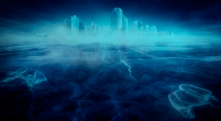
A persistent rumour is that a lost city and proof of ancient human settlement has been discovered beneath Antartica’s ice. This has stemmed from NASA’s information gathered from remote sensing photography taken by Operation Ice Bridge, the largest survey in 3D of its type. There is apparently evidence of Pyramids in formation typical of those in Egypt and around the world which resemble constellations of stars and aligning the same way as pyramids on Mars according to UFO researcher Lee Lewis.
Two of the pyramids were “supposedly” discovered about 16 kilometres inland, while the third was close to the coast. Little is known about the pyramids, with the team of explorers maintaining silence about the discovery. To date no official confirmation has been disclosed regarding if the structures are of synthetic or natural origin.

Grunge state: ‘Starting in 2016, news outlets across the internet picked up on the “pyramids in Antarctica”… And admittedly, from above – as so below – images do indeed look like they reveal unnaturally precise pyramidal structures along the Antarctic plains, such as those near the Shackleton Mountain Range… Their artificiality was purported by “satellite imagery expert” Joseph White… and have been the subject of debate ever since.’
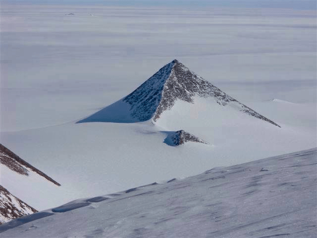
Dr Alfredo Carpineti counters:
‘… the first Pyramid (AKA mountain)… was discovered by the British Antarctic Expedition of 1910-1913. It was then kept secret from… the world by calling it “The Pyramid” and then [using the] name on every single geological survey of the area. These geologists thought they were clever with this double bluff, but they couldn’t imagine that 100 years later “truthers” would see through their ploy and discover that the Pyramid is actually a pyramid… Maybe. Now a second mountain has restarted the wheel of conspiracy theories. It can be found at the coordinates 79°58’39.25?S 81°57’32.21?W. It’s clearly a mountain.’

“The pyramid-shaped structures are located in the Ellsworth Mountains, which is a range more than 400 km long, so it’s no surprise there are rocky peaks cropping out above the ice. The peaks are clearly composed of rock, and it’s a coincidence that this particular peak has that shape,” Dr Mitch Darcy, geologist at the German Research Centre for Geosciences in Potsdam, told IFLScience.’
Lewis stated: ‘Conspiracy theorists went wild… when a video claiming to be from the lost city emerged. It appeared to show extensive ancient ruins hidden in the ice, and was a video supposedly ‘left behind’ by a California TV crew who have been missing since 2002.
Archaeologist Jonathan Gray claimed that the US government is trying to block the video from being seen because it reveals there is a “massive archaeological dig under way two miles beneath the ice”… several online websites [claim] that there is a city in Antarctica and Hitler knew about it, making it a secret Nazi base… [and it is why] the Nazis claimed an area of Antartica as German territory… [sending] an expedition there.’
Ancient Code:
‘It is known that during the Second World War, the Nazi’s carried out a number of strange experiments with alleged technologies unknown to the rest of the world in their attempt to rule the world. They searched the planet for mythical artifacts and otherworldly technology hoping to come across a supreme power that would allow them to conquer the unconquerable.
Curiously, one of the most interesting quotes about Neuschwabenland and Antartica comes from German Navy Grand Admiral Karl Dönitz who said: “The German submarine fleet is proud of having built for the Führer in another part of the world a Shangri-La on land, an impregnable fortress.” Interestingly, according to a number of rumors, ‘Station 211’ [New Berlin]’ did exist, and if it did, then it must have been (maybe still is) located inside the ice-free mountain range in the Muhlig-Hofmann Mountains of Neuschwabenland, aka Queen Maud Land.’
The Germans at this time allegedly mapped the area, discovering a network of rivers and caves, one of which led to a ‘large geothermal lake’. Geologists who participated in the German expedition, confirmed that the areas where vegetation was present were due to hot springs and geothermal sources.
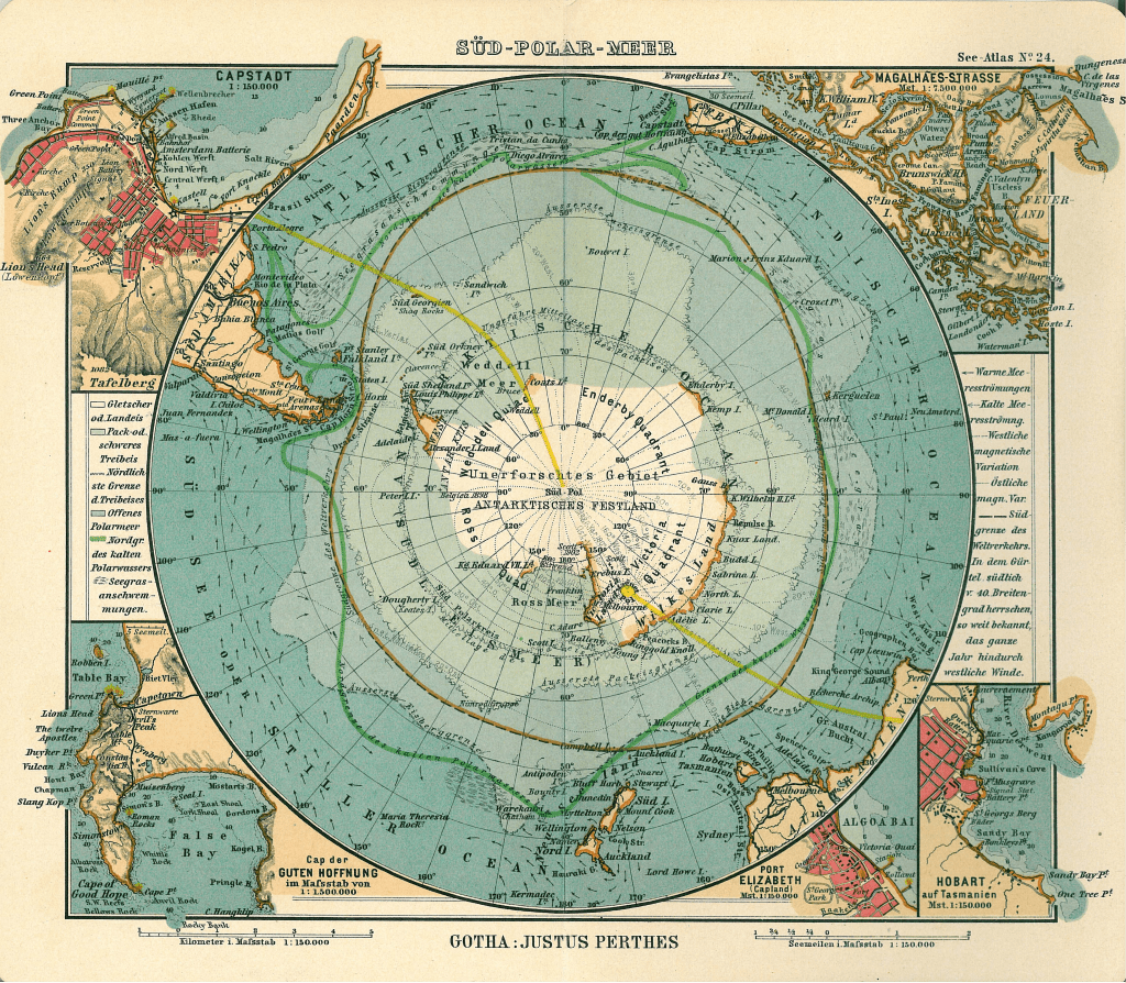
Conspiracy theorists claim the Germans discovered abandoned alien technology, had contact with aliens and endeavoured to make super weapons. Others think the rumoured base still exists, ‘with the Germans, aliens, and the Illuminati planning to launch a New World Order from it.’
It is rumoured that as many as 250,000 senior officers in the Nazi Party escaped in U-boats (submarines) from Germany during the closing days of World War II. Where did they go? Seemingly, they went to Argentina, protected by the sympathetic Juan Peron administration. The potential to escape to a secret base in Antarctica is an attractive alternative for many conspiracy theorists.
Strangely, after World War II had ended, the United States mounted a huge expedition to Antarctica called Operation Highjump. It wasn’t the first time the United States went to Antartica, though it exceeded all other expeditions. More than four thousand personnel (4,700 soldier) and dozens of aircraft (33) and ships (13) were part of the team led by Admiral Richard Byrd. The mission was intended to last six to nine months, yet it ended abruptly after just a little over one month.
One report is that the ‘contingent were being constantly bombarded by artillery, and the men sustained heavy casualties.’ But Byrd was quoted in the Chilean Press stating they were met by a new enemy that “could fly from pole to pole at incredible speeds,” ‘though the U.S. would not confirm his information’, according to Diana Brown. She says, ‘several reports exist of pilots seeing UFOs – flat, disc-like aircraft that chased, but never shot at, them. They also reported balls of light that followed their planes.’
‘The pilots called them “foo fighters”, and these UFOs were supposedly able to shut down their planes’ bombing capabilities. Did these UFOs come from Neuschwabenland, the secret Nazi base built in the 1930s, bragged about by German Grand Admiral Karl Dönitz in 1943?’

‘Did all the brilliant but twisted scientists involved in Nazi atrocities really hunker down in the frozen desolation of the South Pole to continue inventing new weapons, unseen by the world? Or to make contact with reptilian extraterrestrials who shared their advanced technology? The official story from the United States regarding Operation Highjump is that only one plane crashed, killing three pilots. And it’s true the Nazis did mount their own expedition to Antarctica in 1938, though they didn’t take enough personnel to build much of anything, let alone a technologically advanced base capable of creating UFOs.’
The truth may not be so glamorous. It is true Hitler sent a secret expedition to Antartica, in a hunt for margarine fat in case imported sources were cut off. Granted, it may have been the superficial reason if it was a cover for a different mission. At the time, Germans consumed a lot of margarine and a chief component was whale oil. Germany did not want to rely on Norway and thus looked to produce whale oil themselves. As German whaling ships were operating in the southern oceans far away from home, establishing an Antarctic base seemed a sound idea.
In August 1936, the German Foreign Office located unclaimed territory in Antarctica between the Norwegian and British zones, An expedition was sent to explore and claim the region between 20 degrees east and 10 degrees west – part of an area known as Queen Maud Land. The expedition was organised in the summer of 1938, led by Captain Alfred Ritscher (1879-1963), a decorated World War I naval commander and married to a prominent Jewish artist. He selected his crew for the secretive mission based on polar experience rather than membership in the Nazi party.
Eric Niiler comments: ‘After three months of repairs to turn the Schwabenland into an icebreaker, the captain sailed from Hamburg on December 17, 1938, with a crew of 82 scientists, officers and enlisted men, as well as two Dornier flying boats perched on catapults.’

‘There was one Nazi official on board, as required by the regime. The ship reached the Antarctic coastline a month later [on January 19], and began aerial reconnaissance using the flying boats.
The mountainous region had never been explored and the German scientists named it “Neu-Schwabenland” [New Swabia – between 10 degrees West and 15 degrees East] after the ship. These flights had two purposes, to photograph the area for scientific research and cartography, and also to claim it for Nazi Germany.’

‘But things didn’t always work out as planned. On one air flight, the crew [were] running low on fuel and was forced to throw out extra gear to lighten the aircraft weight. That included boxes of the tiny metal swastikas, which were supposed to be dropped across that part of Antarctica to cement the Nazi territorial claim. Those little swastikas were never recovered. The Schwabenland expedition didn’t last long, they completed their work and began the long trip home on February 5, 1939.
On the way home, the ship conducted scans of the seafloor along the Atlantic Ocean. The ship’s scientists detected seismic activity that they believed was a line of volcanoes running north to south along the middle of the Atlantic. Decades later, this line of volcanoes was found to be the Mid-Atlantic Ridge, a region where two of the Earth’s tectonic plates are pulling apart and forming new sections of the seafloor. Much of the expedition’s science was either lost during the war, or kept under wraps until it was finally published in 1958.
Although tales of secret Nazi bases or lost Antarctic colonies still populate the internet… there’s no evidence that Hitler had any further interest in the frozen continent after this expedition returned. Co-author Summerhayes wrote a 2007 journal article spelling out how people have been confusing other military activity after World war II in the region with the earlier Nazi-commissioned expedition.
https://ia600908.us.archive.org/0/items/HitlerAntarcticBase_201903/Hitler%20Antarctic%20Base.pdf
Germany would not set up its first permanent station in Antarctica until 1981.’
Yet in a further twist, purported evidence emerged in support of the United States military’s encounter with UFOs in Antartica in early 1947. The first, is the possible discovery of secret bases. Google Earth photos reveal two large rocky entrances which extend into and below Antarctica’s surface near its coastline. They do not look like natural caverns and according to Scott Waring, ‘they might be entrances to an alien UFO base or a secret facility of some kind.’

Thus claims that UFOs may have assisted ‘fleeing World War II Nazis escape a punitive U.S. Naval expedition, are not so far-fetched…’

The second entrance as shown above is approximately 30 meters high and 90 meters across.

The Google Earth coordinates: -66° 36′ 12.58″, +99° 43′ 12.72″ and -66° 55′ 32.17″, +99° 83′ 82.94″
One of the entrances looks as though it has a ‘metal canopy’ or dome covering it. This suggests that it is artificial. If the entrances are not natural, then who built them, why and when? Are they recent or are they ancient edifices from a bygone age? Whether there was a Nazi exodus or not, it does lend weight to a military confrontation between the United states Navy and UFOs based on or under Antarctica.
Yet there was an extraordinary admission in a 2006 Russian documentary about Operation Highjump during 1946 and 1947, which had access to classified files released by the KGB after the Soviet collapse in 1991. In 1947, a secret Soviet intelligence report was commissioned by Joseph Stalin regarding the Operation Highjump mission to Antarctica.
The intelligence report was gathered from Soviet spies embedded in the United States and revealed that the US Navy had sent the military expedition to actually find and destroy a hidden Nazi base. It was on the way, that they encountered a ‘mysterious UFO force that attacked the military expedition destroying several ships and a significant number of planes…’ suffering ‘many casualties as stated in initial press reports from Chile.’ There remains the possibility the report derived from ‘US disinformation fed to a known Soviet mole.’
Atlantean Gardens highlight mysterious circumstances behind Operation Highjump and events leading up to it. As well as known Nazi activity prior and during the War, ‘events after that date [suggest] something was happening that did not form a part of recognized world history… there are records of continued German naval activity in the area after the war had apparently ended. A book published in 1978, called Secret Nazi Polar Expeditions, relates how the Germans had taken a ship with a small airplane… But the book didn’t say anything about what it supposedly found or what the Nazi party elite believed was an entrance to the inner (hollow) earth.
An interesting document… surfaced… [from] a Joe Watson of Talkeetna, Alaska. Mr. Watson [claimed] it is a copy of a letter written on 2 March 1985 in the German language from a German submarine crewman who was on board. In it is given certain coordinates for their mission, which apparently was to travel to the center of the earth. Their submarine was called U-209 under Captain Heinrich Brodda. The image below is a copy of the original hand-written letter from Karl Unger, crew member of the German U-209, as well as an English translation. In it Karl confirmed that the earth was indeed hollow and that they had successfully reached the inner inhabited earth in the German U-209 submarine after World War II had destroyed Germany.’

‘The letter was sent to his friend… on the surface world who gave a copy of it to a Mr. Woodard, who [then] gave a copy to Joe Watson. Karl had sent the letter from the hollow earth through a German colony in Brazil that had found a cavern that reaches to the hollow earth many years previous. This German colony in Brazil is documented in Genesis For a New Age, having supposedly discovered the cavern entrance back in the 1500’s.
When one does a search at the German archive website looking for information on the missing U-209 German submarine, it shows that the submarine was indeed reported missing. On July 5, 1943 was it’s last reported position between Greenland and Iceland at coordinates 52°00’N-38°00’W. The report said the Commander of the submarine was Heinrich Brodda. In addition, documents obtained by the soviets at the close of WW2… surfaced which shows a 1944 map from the Third Reich detailing not only the direct passageway used by German U-boats to access this subterranean domain, but also a complete map of both hemispheres of the inner realm of Agharta [Agartha], the mythical name of the inhabited subterranean world.’

‘If that seems too unbelievable, compare with those maps, this map done by the famed Tyrolean cartographer and artist Heinrich C. Berann for the National Geographic Society beginning in 1966. The map… [below] clearly shows the continent of Antarctica without its cover of ice.’

‘The intriguing detail… is that there are underwater passageways that run nearly the entire length of the continent and seem to converge at the exact location identified as the opening into the deep inner or subterranean earth.

Agartha
Below is a translation of the Top Secret instructions and specific detailed directions left for the Nazi U-boat Captains to follow in order to reach the inner-world kingdom of Agartha.’

The concept of a hollow Earth is worth considering further, even though it is lumped in with those who argue for a flat Earth.
Ancient Code:
‘In the early 1970’s, ESSA, a project belonging to the Department of Commerce of the United States, gave media access to images of the North Pole taken by the ESSA-7 satellite on November 23, 1968. One of the photographs showed the North Pole covered by the usual cloud; the other one showed the same area without clouds, revealing a huge hole where the pole was supposed to be located.
Vice Admiral Richard E. Byrd of the US Navy… a distinguished pioneer aviator and polar explorer… flew over the North Pole on May 9, 1926 and led numerous expeditions to Antarctica, including a flight over the South Pole on 29 November 1929. Between 1946 and 1947, he… discovered and mapped 1,390,000 km² of the Antarctic territory. The famous Byrd expeditions first entered in dispute of the hollow Earth theories when several articles and books like Worlds beyond the Poles by Amadeo Giannini claimed that Byrd had not flown over the Pole but inwardly through large holes leading into the Earth.’
Allegedly, ‘Admiral Byrd radioed that he saw beneath him, not snow, but areas of land with mountains, forests, vegetation, lakes and rivers and in the undergrowth, a strange animal that looked like a mammoth… just before his death, Byrd had said there existed a land beyond the Pole that was “an enchanted continent in the sky, a permanent mystery of Earth.” That land, according to other theories, was the legendary Rainbow City, home to a fabulous lost civilization.
Leonard Euler, a mathematical genius of the eighteenth century, concluded that the Earth was hollow, containing a central sun and was inhabited; and Dr. Edmund Halley, discoverer of Comet Halley and Royal Astronomer of England also believed that the Earth was hollow on the inside with three “Floors”.
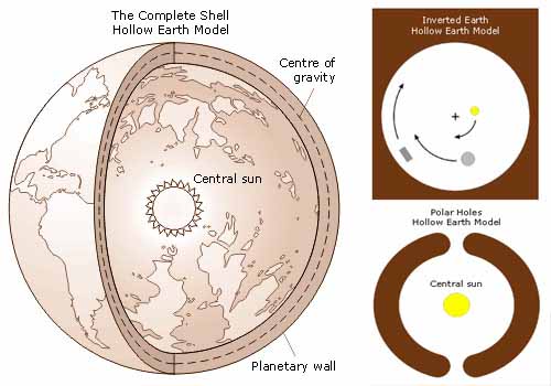
The Macuxi Indians knew about the existence of the Hollow Earth nearly one hundred years ago. The Macuxi Indians are indigenous people who live in the Amazon, in countries such as Brazil, Guyana, and Venezuela. According to their legends, they are the descendants of the Sun’s children, the creator of Fire and disease and the protectors of the “inner Earth.” Their legends speak of an entrance into Earth. Until the year 1907, the Macuxies would enter some sort of cavern, and travel from 13 to 15 days until they reached the interior. It is there, “at the other side of the world, in the inner Earth” is where the Giants live…
… There is a huge Ocean beneath the surface of our planet. Scientists have… discovered a large ocean of water inside the mantle of Earth, and they point out that it is a large water “tank” that could fill the oceans on Earth three times. This incredible discovery suggests that the surface water of the planet came from within Earth, as part of a “complete water cycle on the planet” instead of the dominant theory proposed that water arrived to Earth by icy comets that passed by the planet millions of years ago’ – Chapter I Noah Antecessor Nulla. ‘The existence of this ‘underground ocean’ would explain the great volcanic and tectonic dynamism of the planet.
David Wilcock… [claims] an alliance of ancient civilizations currently resides inside the Earth, and they may soon reveal themselves to the ‘outer’ world. During the formation of all watery planets in the universe… hollow cavities form below the surface of the crust and have their own biome that features bacteria which gives off natural light. “What this means is that you can actually live inside caverns in the Earth that have visible light… it appears that these cavities are used so that more advanced civilizations have a place they can live while they’re managing what takes place on the surface.”
Operation Highjump, led by Admiral Byrd may not have been a military exercise in preparation for a potential conflict with the Soviet Union. ‘There are all kinds of strong indications now suggesting that [Byrd] was sent to smoke out Hitler’s last stronghold there.’ It is decidedly peculiar that it ‘ended in failure and defeat in under 8 weeks, far short of the 8 months that was intended…’ It seems possible that ‘the story of the Third Reich’s advanced technology programs does not end with the collapse of the Third Reich itself.
Would it not have been painfully embarrassing to admit to the American [and] world public that “… here we were, having clubbed the Germans to a pulp in massive bombing raids, monkeying around with that outdated, old-fashioned, glorified fire cracker rocketry the departing Hitler regime left behind, along with Wernher von Braun – while a still-undefeated bunch of high-tech Nazis are hot-rodding it around the globe and maybe even through the universe, snugly ensconced in their never-captured, Antarctic based UFOs?”
Of course, if UFOs were involved in the defeat of the American forces, they may not necessarily be of Nazi origin. Added to the intrigue is the claim about remains of a UFO found on Lavoisier Island on Antartica’s Peninsula (below).
Waring says: “The triangle craft has a hump in the middle and a thicker edge with three sides. It looks metallic and its sitting in an area which appears to be the location of an ancient alien base. This craft was revealed after warm years had melted the ice and snow revealing the secret craft below.”
Meanwhile NASA and other sceptics consider the image an example of pareidolia – ‘a psychological phenomenon when the brain tricks the eyes into seeing familiar objects or shapes in patterns or textures such as a rock surface.’

The photo above is noteworthy, for the suspicious trail begins from what ‘appears to be the collapsed peak of a mountain.’ This suggests that a UFO hit the peak as it crash landed. Though geologists do not agree, insisting that the trail was caused by an avalanche. If so, the avalanche trail is the most uniformly straight line this writer has observed.
Even if these images are doubted, what is not are the events in the summer of 1965, when on June 7th, ‘meteorologist Jorge Stanich from the Argentinian base observed a bright yellow stationary object at a distance of 2,000 meters in the sky, which disappeared after remaining there stationary, a few moments. According to Stanich, the enigmatic object [had] a diameter of roughly 50 meters. Stanich witnessed the same object the following day.
On June 18th, another mass sighting occurred above the Chilean base, also on [perhaps appropriately named] Deception Island. A massive zigzagging light which changed colors from yellow to green and red was visible for approximately 15 minutes. On July 3, nine members of the same base observed for 20 minutes maneuvers of what they called “a luminous, lenticular-shaped mass” which occasionally changed color, and moved across the sky at high speed. Two minutes later the same object was seen by 17 people above the Argentinian base on the same island in a timeframe of roughly one hour’ – Ancient Code.

What makes these sightings credible is the fact that an official documenting of the event was conducted. In July of 1965, media around the world headlined that UFOs had been sighted over Antartica, specifically from the Orcadas Naval Detachment in Argentina as well as from three bases operating on Deception Island – Chilean, Argentinian and British. All three nations allegedly reported the event and four official reports surfaced; two from the FACh (Chilean Air Force); two released by the Argentine Navy; while the United Kingdom remained silent. The above letter which has only recently become available shows the sightings were reported and cataloged by the British Antarctic Survey.
The letter is certainly genuine, with the declassified document having no erasures or blackouts and clearly revealing the credentials of the British Antarctic Survey (BAS), signed by its director, the famous Antarctic expeditionary Sir Vivian Fuchs and addressed to R A Langton of the Ministry of Defence.
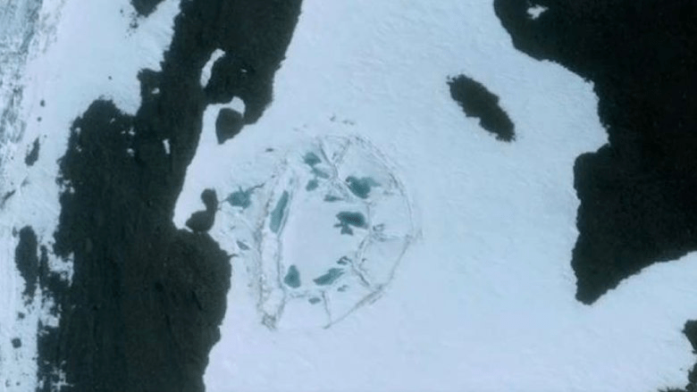
In January 2017, the photograph above emerged of an unexplained image of an oval structure in the ice. It is a few hundred feet across and has an oddly man-made geometric shape.
In January 2019, scientists from NASA and curiously the German Aerospace Center reported a crater deep under the permafrost of Antarctica. Yet the crater was first discovered during an analysis of satellite images of Antarctica, thirteen years earlier in 2006. Scientists consider the crater to have formed when asteroids hit the Earth, causing the extinction of the dinosaurs. This is interesting for the destruction of the dinosaurs may be far more recent than a staggering sixty-five million years ago. Perhaps at the end of the last ice age and as a consequence of the same cataclysm which destroyed Atlantis? Some researchers are not convinced this is the origin of the crater and think it is linked to a secret Nazi base; while others believe the crater was ‘discovered during a US Navy operation to find the entrance into the Earth. They think the crater is the entrance.’
In 2009, scientists found particles of pollen in the atmosphere. A discovery that would lead to the hypothesis that palm trees may have grown there, with summer temperatures reaching at least 21°C. Three years later in 2012, scientists at the Desert Research Institute in Nevada, identified thirty-two species of bacteria in water samples from Lake Vida in East Antarctica. Confirmation that Antartica was once warm enough to plausibly host an ancient civilisation.
Ancient Code state: ‘During Antarctica’s long history, the continent was at one time, located farther north enjoying a tropical climate. What we see now as ice and snow were in the distant past lush green forests inhabited by various ancient life forms. In fact, Jane Francis of the University of Leeds told the BBC in an interview:
“I still find the idea that Antartica was once forested absolutely mind-boggling, we take it for granted that Antartica has always been a frozen wilderness, but the ice caps only appeared relatively recently in geological history.”
‘Interestingly, according to researchers, the Antarctic Peninsula has warmed by an incredible 2.8 degrees Celsius, which is faster than any other part of the world. This means that if this warming were to continue unabated, it is very likely that in the future we could see a “tropical” Antarctica reappear.’
In 2018, enhanced satellite imaging revealed beneath all of Antartica’s ice ‘lies a geological jigsaw puzzle.’ Some of the rock resembles bedrock one would find in Australia and other rocky remnants resemble India’s geological foundations. Grunge state: ‘… lying beneath Antarctica’s icy cover are the torn-up remnants of an ancient supercontinent – a forgotten chunk of our planet before Pangaea’s drift doomed it to an icy grave.’

On Saunders Island which is about one thousand miles from the eastern edge of Antarctica’s coastline, researchers after analysing high resolution South Pole satellite imagery noticed something different about the largest mountain on Saunders Island. On the top of Mount Michael there was an unexpected orange glow on the mountain’s peak. They had found a huge seven hundred foot crater lake of bubbling lava – only one of seven other lava lakes in existence.
Perhaps of most interest is the fact that Antarctica is ‘swimming in oil.’ The South Pole is estimated to contain over ‘two hundred billion barrels of oil.’ Far more than the combined oil deposits in Kuwait and Abu Dhabi for instance. While the international treaty of 1959 came into effect in 1961 to protect Antarctica from ‘military activity or mineral extraction, a cynic would feel obliged to point out that a great majority of research carried out in Antarctica is geological in nature.’ Governments surely want to know what money making substances lay beneath the ice sheets rather than ‘proving or disproving theories about Atlantis.’
As Antarctica is not a country and without a government, it does not possess the ‘protective power of sovereignty.’ Thus the ‘greatest threat to Antarctica’s pristine state is politics…’ The treaty protecting Antarctica expires in 2048. Realistically, nations will begin to geopolitically jostle more vigorously for their slice of the Antartica pie, as that date approaches.
Perhaps the greatest conspiracy surrounding the ice content is that Antartica does not exist. Not as we believe anyway. The Flat Earth Society teach the Earth is flat or a plane – not a globe or sphere – and thus there is no South Pole. The North Pole is the centre of the world. Antarctica or the South Pole is actually composed of a thick wall of ice about 30 to 60 metres (100 to 200 feet) high which surrounds our planet.

The wall stops anything from falling off the edge of the Earth. Though confirmation of the existence of the wall isn’t possible because ‘world governments and the United Nations have strict no-fly and no-sail zones around Antarctica.’ While this theory does not negate the historicity of Atlantis it could certainly put a serious dent in Antartica being the lost content of Atlantis. It is not the purpose here to debate the Flat Earth theory or to either confirm or deny its validity. The following link is available for any reader wishing to investigate further: http://www.atlanteanconspiracy.com/2015/06/south-pole-does-not-exist.html

For a description of Atlantis, one has to rely on Plato. According to Plato the twelve Olympian gods divided the Earth amongst themselves, with Poseidon being apportioned Atlantis. Poseidon, also known as Neptune and god of the sea and storms, fell in love with a human woman named Cleito. Poseidon ‘protected’ her by placing her in a cave and then turned the island into a series of concentric circles of land and water.

Cleito gave birth to an incredible five pairs of twins. The eldest child was called Atlas. He was appointed rightful king of the island and the ocean that surrounded it. The island continent was named after him, with the Greek phrase Atlantis nesos meaning “island of Atlas.” The Atlantic Ocean is ostensibly named after the same king. This Atlas is not to be confused with the Titan Atlas who lost the war against the Olympians and as a punishment was forced to hold up the celestial spheres, not the terrestrial globe as mistakenly taught.
While Atlantis was an island and likely a continent to boot, its capital was a city described as: “(115d) For, beginning at the sea, they bored a channel right through to the outermost circle, which was three plethra (303 feet) in breadth, one hundred feet in depth, and fifty stades (5.7 miles) in length; and thus they made the entrance to it from the sea like that to a harbor by opening out a mouth large enough for the greatest ships to sail through.”
“(116b) And they covered with brass, as though with plaster, all the circumference of the wall which surrounded the outermost circle; and that of the inner one they coated with tin; and that which encompassed the acropolis itself (116c) with orichalcum which sparkled like fire.”
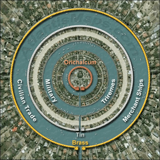
“(117d) And after crossing the three outer harbors, (117e) one found a wall which began at the sea and ran round in a circle, at a uniform distance of fifty stades from the largest circle and harbor, and its ends converged at the seaward mouth of the channel. The whole of this wall had numerous houses built on to it, set close together; while the sea-way and the largest harbor were filled with ships and merchants coming from all quarters, which by reason of their multitude caused clamor and tumult of every description and an unceasing din night and day” – Critias, Plato.
This record from Critias describes a wall which fully encircled the circular capital city, paralleling its outermost ring at a distance of 50 stades (5.7 miles – 9.2 km) with the ends of the wall converging at the sea. As the multi-ringed city had a diameter of 3.10 miles (5.0 km), this would put the wall at 14.5 miles (23.4 km) in diameter and over 45 miles (72.4 km) in circumference. This means ‘the total area of the royal city of Atlantis (443 square km) would have been so great that it exceeded that of today’s London with 303 square km… Atlantis – a city greater than today’s London?’ This is not hard to fathom or accept as the antediluvian age was technologically superior to ours today and Atlantis its symbolic and literal epitome of advancement – Chapter I Noah Antecessor Nulla; Chapter XXI The Incredible Identity, Origin & Destiny of Nimrod; Chapter XXII Alpha & Omega; article: Na’amah.
Grunge: ‘While Atlantis is pretty handily the most famous sunken lost continent, it’s hardly the only one. There are a pretty shocking number, really. To paraphrase Oscar Wilde, to lose one continent may be regarded as a misfortune; to lose a dozen looks like carelessness.’
Two of the most well known mythical lost continents of pre-history apart from Atlantis, are Lemuria and Mu (below).

Though this writer is undecided whether Le-Mu-ria and Mu are distinct or refer to the same land mass. The most common interpretation is to locate Lemuria (above) as a sunken continent in the Pacific Ocean.
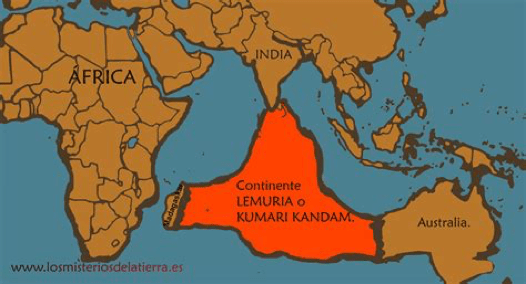
The next preferred location is in the Indian Ocean (above and below),
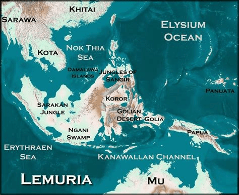
This writer would lean towards the Pacific Ocean basin, with the map below presenting a plausible size and shape formation for Lemuria – which uncannily is not unlike the shape given for Atlantis or present day Antartica. It may account for the islands of the Pacific which are but the tops of former mountains with their tips protruding above the sea’s surface.

For instance, scientists have found evidence that New Zealand is the surface remains of a recently lost eighth continent – Zealandia (below).

Another possibility, is that Lemuria did not sink and that it is actually Antartica.

Finally, the scenario exists as portrayed in the above map, that Atlantis wasn’t even near the Atlantic Ocean or the American and European continents at all. What if it was in a southerly location all along. This would mean its shift further south to its present South Pole location as Antartica is yet more plausible. It also opens up the question, whether Atlantis and Lemuria were actually adjacent to one another or even adjoined as Greater and Lesser Antartica are today.
Evidence to support this is the existence of the sunken continents of Zealandia and Mauritia with the Kerguelen Plateau in the Indian Ocean, but ‘no geological formation under the Indian or Pacific oceans is known that could have served as a land bridge between… [other] continents.’ Yet not so in the Atlantic Ocean, where according to one source, ‘samples taken from the floor of the Atlantic Ridge… revealed “freshwater plants dated to about ten thousand years ago” which indicates that the land at the bottom of the ocean now was above the surface a long time ago.’
It was James Churchwood who referred to Lemuria as Mu, a lost continent of the Pacific Ocean. Churchward himself ‘appropriated this name from Augustus Le Plongeon, who had used the concept of the “Land of Mu” to refer to the legendary lost continent of Atlantis.’
A further point supporting Atlantis and Lemuria/Mu being the same landmass, is where is the room for it in the Atlantic? When the existence of a sunken landmass bridging North America and Europe has been established. Whereas a former sunken continent in the vast space of the glaringly landless Pacific Ocean has not been confirmed.
The additional piece of the puzzle perhaps supporting Antartica as the descendant continent of Atlantis-Mu, is the likelihood of it having shifted position twice. Once after the global cataclysm which coincided with the sudden mass extinction of many life forms and again after the most recent cataclysm to engulf the world – refer Chapter XXV Italy: Nahor & the Chaldeans; and Chapter XXI The Incredible Identity, Origin & Destiny of Nimrod.
We have touched upon a proposed early history for Atlantis and Lemuria as two competing and waring factions – Chapter XXII Alpha & Omega. They represented an eternal battle between the forces of light and darkness which originated beyond our Solar System, yet spilled over here on an early Earth.
According to Susan Brunton, the Lemurians were highly advanced and had learned a way to unlock the pathway to the fifth dimension. ‘Not only were Lemurians able to unlock the fifth dimension, but they were also easily able to switch back to the fourth and third dimension at will.’ Hence ‘Lemurians performed unimaginable feats. Lumeria was the groundswell of spiritual knowledge and the spiritual prowess they possessed has never been paralleled in history.’ That is, until our foreseeable future. For this ability to transform is derived from a wicked source and these evil forces are currently at work in bringing this reality about again – refer articles: The Establishment: Who are they… What do they want? and Principalities & Potentates: What they want… Who they are.
Frederick Lenz: “We live in an age that’s repeating itself endlessly. We’re getting closer again to the techno-chic world we saw in Atlantis that occurs in countless planes. It’s indigenous to enlightenment.”
Brunton continues: ‘The Lemurian civilisation was the founding father of many other civilisations. It was known as the ‘Motherland’. Even Atlantis emerged years after Lemuria. And when it did, it constantly battled against Lemuria because of conflicting ideologies. Due to this disparity, they laid waste to each other’s land, bringing about an age of darkness and malice. Lemurians were insistent that there should be no compulsion in spirituality. People should be given the freedom to travel towards spirituality at their own pace. They didn’t want the less spiritually evolved cultures to be coerced into spiritual attainment. But, Atlantis wanted to abuse its power and control smaller civilisations.’
Lemuria had thirteen colonies – much like the genesis of the United States – Chapter XXXIII Manasseh & Ephraim – the Birthright Tribes. Atlantis was a Lemurian offshoot with a dark agenda for “genetic modification and [a] creation of a new form of being” – Revelation 13:16-18.
Lemuria and Atlantis were highly evolved technological societies with ‘advanced knowledge of cymatics and systems of energy resonance.’ Cymatics is the science of visible sound, whereby ‘when sound meets a membrane, such as a water surface, it makes the sound visible.’ For instance, the Great Pyramid was built according to cymatic principles and geodetic knowledge from a legacy of Atlantean knowledge after the global cataclysm 13,000 years ago – refer article: The Pyramid Perplexity.
Michael Tellinger explains that ‘Sound and resonance are responsible for everything in creation… [and] every frequency has its own specific shape.’ These tools of sound and frequency were allegedly used by alien beings to ‘manipulate our pineal gland and manipulate our DNA’ – refer article: 33.
The scriptures confirm this unsavoury reality: “And you he made alive, when you were dead… following the course of this world, following the prince of the power of the air, the spirit that is now at work in… disobedience…” – Ephesians 2:1-2, RSV.
The understanding that the world is heading into a transitional period is corroborated by those who channel spirits. The phase we are entering is a re-enactment of the civilisation in the antediluvian age. A time which the Bible predicts – Matthew 24:37. One such person is Christina, where she claims the following:
‘This present time is triggering a lot of energies from that time period [in Atlantis] from your soul level… “it’s our second chance at Atlantis. It’s our second opportunity we get to redo Atlantis and we can see if we are going to stay in a higher frequency or if we are going to fall to greed.” ‘There are two lost continents and civilisations [which were destroyed in a great flood]. Lemuria was the original civilisation on the Earth, which was at a very high frequency [of vibration] – a spiritually focused society – like Heaven on Earth.’
Christina sees visual memories of Lemuria, saying it was a colourful and vibrant place with lots of fruits and vegetables – perhaps like the Garden of Eden; refer article: The Eden Enigma. There is a strong connection with nature, crystal technology, energy and healing. The residents did not use money but bartered with one another – sharing, exchanging and collaborating with one another innocently. Life was ‘equal, loving, compassionate in Lemuria.’
When people today discuss a new Earth and any type of ascension or shift to a higher vibrational frequency on a higher plane it is described as having similar energies as Lemuria. But this is incorrect and a lie spread by the Establishment’s hidden and secret rulers. We are not ‘returning back to true collaboration, operating from love, compassion and forgiveness.’ Rather, the Adversary’s plan is to return humanity to an Atlantis agenda of domination, control, enslavement, paranoia and misery – Article: Asherah. The New Age program is nothing but a precursor of a mind-boggling con-trick – 2 Thessalonians 2:1-12, Revelation 13:1-18.
James Churchward: “Mu as the home of an advanced civilization, the Naacal… was dominated by a ‘white race’ that was superior in many respects to our own.” ‘He said that 12,000 years ago, at the alleged time of its demise, [sixty-four million] people inhabited Mu, in other colonies, continents, and many large cities.’ Eventually ‘Mu was completely obliterated in almost a single night after a series of earthquakes and volcanic eruptions.’ This description was based on “a set of ancient sunburnt” clay tablets, ‘supposedly in a long lost “Naga-Maya language” which only two other people in India could read. Having mastered the language himself, Churchward found out that they originated from “the place where man first appeared – Mu.” The 1931 edition states that “all matter of science in this work are based on translations of two sets of ancient tablets: the clay tables he read in India, and a collection 2,500 stone tablets that had been uncovered by William Niven in Mexico.”
Constant readers having read Appendix VIII: When the Creator came to dwell with His Creation, or The Adam and Eve Story by Chan Thomas, will recall that the last words uttered by Christ were in Naga, an ancient language of the Maya and spoken in Northern India at the time of Christ. While we showed that Christ probably learnt this language on his travels to Parthia, we did not know the significance of why he would use this language in his final words. If it was an original language in the antediluvian age or possibly even the pre-Adamic epoch, then this would be more than a mere coincidence.
The Numerologist website says the Lemurians originated from a number of extraterrestrial races who visited Earth from other planets. They principally originated from Alpha Centauri, Sirius and the Pleiades. The common thread is that the advanced civilisations of Lemuria and Atlantis were lost in a great flood or deluge. The Lemurians aware of their approaching demise, used their ‘expertise of crystals, energy… sound and vibrations to create an enormous subterranean city’, so as to ‘preserve their knowledge, culture, records of antediluvian Earth’s history, and treasures.’
The same source states the Lemurians live underground in a fourth and fifth dimension reality. If this is the case, then these beings are not human but what would be described as angelic (or alien) – and not the good kind, even though they are portrayed as such. Twenty-five thousand Lemurians were apparently able to migrate to this inner earth city. Any kind of future blurring between our third dimension and the fourth and fifth dimensions, means interaction between humans and Lemurians could be possible as they would become visible to humanity. This would not be a good state of affairs and one of great peril for humanity – Article: Principalities & Potentates: What they want… Who they are.
A recognised work is The New Atlantis by Francis Bacon – the illegitimate son of Elizabeth I and the identity behind the quill of Shakespeare and who was instrumental in helping to colonise the New World – which revived interest in the lost continent despite the book not really being about Atlantis – refer article: The Shakespeare Shadow. ‘However, at the time, European settlers were trying to uncover the origins of the Mayan people, and Bacon’s work helped spark the idea that maybe the Maya were from Atlantis.’
Grunge: ‘The work that really touched the match of Atlantis to the [powder keg] of the popular imagination was an 1882 book called Atlantis: The Antediluvian World by Ignatius Donnelly, who also wrote other works… on such topics as the secret real author of Shakespeare’s plays (he, perhaps coincidentally, attributes them to Francis Bacon…). Donnelly uses… science and linguistics… to propose that not only was Atlantis real, but that it was in fact the origin of all people in the Americas, Europe, and the Near East… his ideas became wildly popular, and people were soon looking for the real location of Atlantis.’

Ignatius Loyola Donnelly (1831-1901) was an American politician, Congressman and populist writer; while detractors would label him a pseudoscientist.
Grunge continue: ‘Artists and fiction writers weren’t the only ones to pick up the Atlantis ball and run with it. One person majorly influenced by Donnelly’s book was Russian circus horse rider turned religious leader Madame Helena Petrovna Blavatsky, who founded the Theosophical Society in the 1870s. One of the major works of theosophy is Blavatsky’s The Secret Doctrine, which Blavatsky claims was dictated in Atlantis itself. The Secret Doctrine has had a surprisingly enduring influence on later cultural depictions of Atlantis. Blavatsky claims there are seven root races of humanity… [the second were] the Hyperboreans, who lived at the North Pole but did not have bodies… Fourth were the Atlanteans… Fifth were the Aryans, which is to say, Blavatsky’s own race. The sixth and seventh races are still to come… Blavatsky’s version of Atlantis is… different from Plato’s. To her, they were heroic figures (contrasted with Plato’s warmongers)…’
An influential group who believe in the legacy of Atlantis are the Establishment. David Wilcock discusses this potential connection in his book, Awaken in the Dream: Contact with the Divine: ‘The Illuminati believed in Atlantis… They also felt they were the surviving descendants of the mighty civilization, and had retained many of its secrets that were lost to the general public.’ Wilcock explains that the global elite collaborate with non-terrestrial beings who are members of the Orion Confederation. Humans who are placed as leaders on the Earth in positions of power are initiated into this secret. He states: ‘As the years went by, I found that the secret Illuminati religion absolutely believes Atlantis is real and that there [were] gods on Earth in those days who withdrew and abandoned them.’
Grunge: ‘If [mentioning]… “enduring influence” and “super racist” and “Aryan” with regard to Blavatsky’s work set off any alarms, it should have, because guess which goose-stepping murder boys were big fans of The Secret Doctrine?’ We have come full circle so-to-speak, returning to the Nazis who were so intrigued with Antartica – Chapter XXVIII The True Identity & Origin of Germans & Austrians – Ishmael & Hagar.
‘The Nazis seeking out magical and occult items is not strictly the stuff of movies… The 1985 book The Occult Roots of Nazism describes how Nazi philosophy had many ties to ariosophy, a white nationalist occult philosophy with roots in Blavatsky’s theosophy. Foundational works of Nazi philosophy such as Alfred Rosenberg’s The Myth of the Twentieth Century are based around a racial theory that posits that modern white Europeans were descended from the Hyperborean people of Atlantis… based on ideas from Blavatasky’s work.’
Considering all the options for where Atlantis may have once been located only highlights the flaws in each individual argument. There are only two viable options regarding Atlantis.
First, there was no island continent of Atlantis in humankind’s pre-history. Any stories about it are not mythic legends of an actual place, but just a fantasy. Just as all the stories of a global flood from all around the world are just imaginative stories made up by bored people. Ignore the fact that they dovetail with each other, derive from every continent and have persisted to us today.
Second as the constant reader will be aware, we have good reason to believe there were humans before the ending of the last Ice Age and that their cultures and civilisations were destroyed in a cataclysm consisting of violent volcano eruptions; enormous earthquakes; and ferocious flooding during the Younger Dryas Stadial some 13,000 years ago. Therefore, it stands to reason that those lands had names.
As Atlantis and Lemuria have stood the test of time, it means for Atlantis in this case that it either sank beneath the ocean’s waves or still exists today. If it sank, reason enough, the search for it continues. If it did not sink but was flooded, shifting position and gradually icing over; then Antarctic is the only logical answer.
But cozy islands of escape He wipes right off the map. No one gets away from God.
Nahum 1:8 The Message
For this reason every one of your faithful followers should pray to you while there is a window of opportunity. Certainly when the surging water rises, it will not reach them.
Psalm 32:6 New English Translation
“Atlantis: Fabled. Mystical. Golden. Mysterious. Glorious and magical. There are those who claim that it never was. But then there are also those who think they are safe in this modern world of technology and weapons. Safe from all the ancient evils. They even believe that wizards, warriors, and dragons are long dead. They are fools clinging to their science and logic while thinking it will save them.”
Sherrilyn Kenyon
“Atlantis will rise again.”
Charles Olsen
© Orion Gold 2023 – All rights reserved. Permission to copy, use or distribute, if acknowledgement of the original authorship is attributed to orion-gold.com